The Nagoldtal cycle path starts at the source of the river at Urnagold (Seewald-Besenfeld) on the B294 ![]() . It follows the river downwards to its confluence with the Enz. The route between 1 Nagold
. It follows the river downwards to its confluence with the Enz. The route between 1 Nagold![]()
![]()
![]()
![]() and 2 Pforzheim
and 2 Pforzheim![]()
![]()
![]()
![]() is part of the Heidelberg-Black Forest-Lake Constance Cycle Route
is part of the Heidelberg-Black Forest-Lake Constance Cycle Route![]()
![]()
![]() .
.

.jpg/350px-Panorama_Nagold,_Stadtkirche_und_Enz_(1).jpg)
Route profile

Map of Nagoldtal-Radweg
- Length: Total length of the route approx. 90 km
- Signposting:
- Slopes: Downriver approx. 290 m gradient
- Path condition:
- Traffic load:
- Suitable bike:
- Family suitability:
- Inline suitability:
background
preparation
getting there
Public transportation
The Velobus brings riders and bicycles from May 1st to October 3rd on Saturdays, Sundays and public holidays 1 Pforzheim Central Station![]()
![]()
![]() to the starting point of the Enztal cycle path to the source of the Enz 3 Gompelscheuer
to the starting point of the Enztal cycle path to the source of the Enz 3 Gompelscheuer![]()
![]() and to the Nagold spring at Urnagold.
and to the Nagold spring at Urnagold.

By bicycle
In the street
Route description with sights
Urnagold - Nagold: 41 km
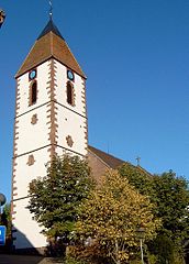
- Urnagold: The Nagold rises in the Seefeld district Besenfeld Urna Gold, the small St. John's Church is worth seeing here. The path goes from here about 1.5 km along the B294
 until after
 - Broom field. Most of the cycle path goes parallel to the K4774 K 4774 down the valley to
- Ore mine, also a district of Seefeld. Now the path goes about 3 km along the Nagold dam, a popular meeting place for anglers and water sports enthusiasts. The offer also includes information about the lake. We continue along the Nagold, past sawmills and fish farming basins
- 4 Altensteig


 in the Wikidata database") . The old castle and the Protestant town church are worth seeing here. Thanks to numerous well-preserved half-timbered houses, the city belongs to German half-timbered street. It goes on after
. The old castle and the Protestant town church are worth seeing here. Thanks to numerous well-preserved half-timbered houses, the city belongs to German half-timbered street. It goes on after - 5 Ebhausen And then to
- Rohrdorf. Worth seeing is the town hall, formerly a commandery of the Order of St. John. Finally one reaches
- 6 Nagold

Nagold - Calw: 30 km
- Nagold: Hohennagold ruins, medieval old town, the old tower are just some of the sights.
- 7 Wildberg: The city lies on a circular mountain, formerly protected by a city wall. The witch tower and the old town hall are witnesses of the past. Continue to
- Teinach station, the train station of the remote town 8 Bad Teinach-Zavelstein.
- Kentheim is a district, on the way is the Candiduskirche. You finally arrive along the Nagold
- 9 Calw
_-_Kernstadt.jpg/350px-Wildberg_(Wuerttemberg)_-_Kernstadt.jpg)


Calw - Pforzheim: 31 km
- Calw: The leather street in the old city of tanners and timber dealers
- Hirsau: Calw district, ruins of the monastery a little off the bike path,
- Ernstmühl, Part of Hirsau
- 10 Bad Liebenzell: Castle ruins, thermal baths, health resort and Paracelsus spring
- 11 Unterreichenbach
- 12 Dillweissenstein: Kräheneck and Rabeneck castle ruins
- 13 Pforzheim: Jewelry and watch industry, jewelry museum


Overnight locations
security
trips
References to literature and maps
Cycle guide
- Cycling map - Leporello Nagoldtal cycle path. Publicpress-Verlag, 2010, scale 1: 50,000, ISBN 978-3-89920-593-0