
The Oodnadatta Track is a non-asphalt runway that leads from Marree, South Australia to Marla, South Australia leads. The route runs approximately 200 km east of the Stuart Highways to Oodnadatta parallel to the route of the Old Ghan and the Overland Telegraph Line (OTL). It then turns to the northwest and reaches the Stuart Highway in Marla after 621 km.
background
The Oodnadatta Track follows an ancient trade route used by the indigenous people and in the footsteps of the explorer John McDouall Stuartwho was the first to cross the Australian continent from south to north on this line in 1862. Based on the detailed records, the Australian government planned a telegraph connection from 1870 Port Augusta to Port Darwinwhich was put into operation in December 1871. A rail link from Adelaide via Alice Springs to Darwin has begun. In 1884 the railroad reached Marree, and six years later Oodnadatta. Rail operations were discontinued in 1980 due to the repeated damage to the route caused by adverse weather conditions. Along the route there are many remains of the route that have not found any use in Queensland's sugar cane fields, as well as remains of equipment used to operate the OTL. The Oodnadatta Track also runs through a field of artesian springs that extend to the east from Lake Callabonna on the western edge of the Strzelecki desert in an arc to the north of Oodnadatta to the western edge of the Simpson Desert extend.
preparation
The Oodnadatta Track runs through the outback on the edge of the Great Artesian Basin. The largely flat landscape consists of very flat dunes and large scree and rock plains. The greatest distance between two refueling points is 207 km. The recommended travel time is April to October; it is extremely hot in the Australian summer. After heavy rainfall, the route is difficult to drive and mostly closed. The Oodnadatta Track is an earth and gravel road with corrugated iron sections. There are a few sandy stretches. There are many, mostly dry streams to be crossed on the journey. After rainfall there is a risk of sometimes considerable leaching.

The route can be driven by normal cars or mobile homes, especially after using a grading machine. However, these vehicles are not designed for the use of gravel roads, which does not rule out damage even in good road conditions. An off-road vehicle is recommended where high ground clearance is more important than all-wheel drive. The car should have basic equipment with tools and at least one spare wheel and small spare parts. A four-wheel drive vehicle is mandatory for side trips, for example to Lake Eyre. Then a HiJack jack and a compressor to regulate the tire pressure are helpful. If you don't have a satellite phone, don't want to rent one or don't have a radio with you, you should have at least one emergency beacon (Epirb) carry with you.
The traveler should be familiar with the use of a map and compass. GPS is not absolutely necessary. The map material published by Hema-Verlag is ideal Great Desert Tracks Eastern Sheet Map: Hema at. The map issued by the RAA (Royal Automobile Association of South Australia) office in Port Augusta Flinders Ranges & Outback is free for ADAC members.
No special permits are required to drive on the Oodnadatta Track. The Desert Park Pass - AUD 150.00 - from the South Australian National Park Administration (park administration email address: [email protected]) is required for the detour to Lake Eyre National Park. If you do not want to visit any other parks, there are also permits for overnight stays on a daily basis - AUD 20.00 / vehicle / day. The passport or permit is also in Marree at the Marree Telecenter (Tel .: (08) 8675 8222), in Oodnadatta at the Oodnadatta Hotel (Tel .: (08) 8670 7804) or in the Pink Roadhouse (Tel .: (08) 8670 7822) and in William Creek at the William Creek Hotel (Tel .: (08) 8670 7880).
getting there
Marree can be reached from the south Port Augusta Coming on the B83 after 368 km via Hawker and Leigh Creek. The tarmac ends at Lyndhurst and then it's 78 km on a well-maintained gravel road. Marree is also via the north from Birdsville, Queensland, 520 km away Birdsville Track There are accommodation, shopping and fueling facilities in Marree.
Drive

Marree
The first of many artesian springs is at Marree. After the junction of the Birdsville Tracks Following the Oodnadatta Track through Marree for 1300 m, after leaving the village a road leads to the right past the racetrack after 2200 m to Hergott Spring.
Detour Lake Eyre North
On the Oodnadatta Track, the traveler reaches the junction of Public Access Route 2 (PAR 2) after 1200 m. This slope leads to Muloorina station, a cattle and sheep farm that owns the Hunt Peninsula in Lake Eyre North gave to the South Australian government. This is the one today Elliot Price Conservation Park and part of Lake Eyre National Park. The Muloorina station is 50 km away; both at the farm at the Frome Creek waterhole and after another 44 km at the Post Bay level at the Lake Eyre North you can stay overnight. The owners donate the overnight fees for the overnight stay at Frome Creek to the Royal Flying Doctor Service (RFDS).
The drive to the farm can be risked in a normal car if the weather conditions are good and the path has been leveled shortly beforehand. It is advisable to use a four-wheel drive vehicle for the onward journey to Lake Eyre.
Marree - Lake Eyre South
Back on the Oodnadatta Track, the traveler reaches the remains of the after ten km Callanna siding, a water tower and a water crane for steam locomotives. Siding means something like siding. To the Sidings arose next to the supply facilities and workshops for the Old Ghan small settlements for the workers. The stop at the Callanna siding so shortly after leaving Marree was lodged because the water of the Callanna Creeks formed no scale during steam generation.
The Oodnadatta Track leads through stone desert (Gibber Plains) by Report (Old Man Saltbush) and bush plums (Native plum), as well as overgrown by the Coolibahs streams.
After another 17 km the piste reaches the Wangianna Creek and after crossing it on the left Wangianna Sidingof which an accommodation building is left. Now there are still six km to the dingo fence. The track then crosses three streams on one level. The flora becomes more varied: different types of acacia grow especially in the streams, the Coolibahs are joined by emus bushes. At the Alberrie Creek, the first of these three streams, are the remains of the Alberrie Creek Siding. A wrecked car was welded to the former water tower so that the sculpture looks like an oversized dingo. in the Mutonia Sculpture Park there are other works of art that can be seen from afar, such as two aircraft standing on the stern or a human sculpture made from car parts. When visiting the park, donations will be made in a Honesty box, asked.
After a total of 70 km, a slope branches off to the left Bopeechee borehole from. This borehole supplies the mining companies of Roxby Downs with water (33 million l / day). After another 500 m the Borefield Roadto the via Roxby Downs (122 km) and Woomera (198 km) Stuart Highway (205 km) leads.
Detour Hermit Hill Spring Complex
53 km from Marree, the road branches off to the left Innis Springs Homestead from. To the right of the Oodnadatta Track is the Hermit Hill Spring Complex. It consists of nine active artesian springs where plant species can be found that show a connection to the Gondwana rainforest. The area was formerly a burial place of the indigenous Arabana tribe living here and is still important for the belief of the Arabana today. The place is called Wibma-malkara (Initiation Ground of the Dreamtime). The area may only be entered after consultation with the Arabana tribe.
Lake Eyre
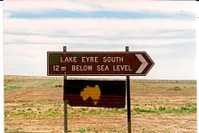
Five km west of the Borefield Road the Oodnadatta Track leads on a bridge that is at sea level over the Gregory Creek and after another ten km the slope reaches the junction to Lake Eyre South twelve m below sea level. Lake Eyre consists of two lakes that run through the Goyder Channel are connected. The lake is the largest in Australia and the sixth largest inland lake in the world. The lake almost always falls dry because of the rapid evaporation. In the past 160 years it has been completely filled with water three times. From 2009 to 2012 there was water in the lake every year, but not up to its peak. Then the lake is an Eldorado for water birds. Driving on the salt crust is not only a criminal offense, but also carries the risk of breaking in, resulting in costly recovery.
Lake Eyre South - Williams Creek
The landscape changes again after the junction of Borefield Road. The stone and scree desert become salt lakes and loam sinks. The vegetation is also becoming sparse. It now consists of Nitrariaceae (Nitre Bush) and Samphire, especially low shrubs found in very dry areas.
Curdimurka
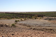
After ten km the Oodnadatta Track turns sharply to the southwest. Here is on the right of the route of the Old Ghan Curdimurka siding. The remains consist of a water tank, a tower-like water desalinator and a railway workers' accommodation with nine rooms as well as a restored short section of the Ghan route and the OTL. The Ghan Railway Preservation Society restored and maintained these ruins. In addition, it has restored four km of track and a corresponding section of the OTL. The reason was that until a few years ago, the Curdimurka Outback Ball took place. A large wooden floor was laid out for this purpose and up to 5000 people in evening wear streamed here from all parts of Australia with private planes and four-wheel drive vehicles. Overnight stays are allowed here. After two km after driving through Stuart Creeks, the driveway turns into Stuart Creek Homestead to the left. About two kilometers to the north are the remains of the railway bridge over Stuart Creek. With 433 m and 57 arches, this is the second longest bridge on the route of the Old Ghan.
Mound Springs
After about 13 km the piste reaches the Wabma Kadarbu Mound Springs Conservation Park. It was set up to protect the artesian mound springs that often emerge here. The driveway that branches off to the left to the most famous - The bubbler and Blanche Cup - reaches the track after another seven km. The springs are surrounded by a green dam and serve as a habitat for many water birds. They are home to unique crustaceans and snails. Hamilton Hill, which emerged from a dried up spring, is also nearby. Entry to the springs is AUD 10.00. A circular path leads through the park. As soon as this reaches the Oodnadatta Track again, after 700 m a lane turns off to Coward Springs. You can find some here too Mound Springs, the ruins of Coward Springs, a former small town, and a campsite.
- 1 Campground & Camel Tours and Safaris, Coward Springs, SA (135 km west of Marree). Tel.: 61 (0)8 8675 8336. Admission: AUD 2.00 pp, overnight stay: AUD 12.50 pp, contact form.Open: every day.
On the further course of the Oodnadatta Track, salt lakes and clay pans become increasingly rare and stone or scree fields come to the fore. At the same time, more acacia species are growing again. Six km after leaving Coward Springs is on the left of the slope Kewson Hill, a former hill spring. According to legend, seven sisters peeled onions here. They placed the dark outer skins on the south-western side, the light ones on the other side of the spring. This is how the different colors of the hill came about. 18 km further on there is another even larger hill on the left of the road, Beresford Hillwhich was also created from a dried up spring. Nearby are the ruins of the Beresford Siding, consisting of remains of railway systems, a telegraph station and a radar station used to control the missile test in the Woomera Prohibited Area was used. 2.5 km further to the northwest, a shady wood appears to the right of the track, a rare sight on the Oodnadatta Track, which was created by a small reservoir created to ensure the water supply for the locomotives. Today the lake is used as a cattle trough.
After a further 8 miles, to the left of the track, are the ruins of Strangway Springs 2.5 km away. One of the first sheep and cattle farms in northern South Australia was established here in the 1850s. The main building was built in 1872 Repeater station the OTL, because after about 200 km the signal in the OTL became so weak that it had to be repeated - and that was not yet automatic at the time. At that time Strangway Springs was a small settlement with a hotel, pub and police station. It is not allowed to stay overnight at the ruins.
The Oodnadatta Track now leads through flat dunes, which are barely recognizable because they are heavily overgrown. After 15 km you pass the on the left Irrapatana siding and after about 20 km the salt lake appears on the left Lake William on.
Detour Lake Eyre North
Seven km before the traveler reaches William Creek, PAR 13 branches off to the right Halligan Bay at Lake Eyre North. Overnight stays are permitted at a distance of 250 m on either side of the track. There is a distance of 500 m from cattle troughs and 1000 m from farm buildings. in the Lake Eyre National Park is overnight only in designated places around the Halligan Point allowed. Driving on the surface of the lake is prohibited; Rescue operations are time-consuming and costly. A four-wheel drive vehicle with very good equipment is required for the 62 km long slope. Drinking water for several days should be carried along. Travel to Halligan Bay is not recommended after rainfall or when it is forecast. If you are surprised by the rain, you should stop and wait for the track to dry - that only takes a few days. If you get stuck or have a breakdown, you should definitely stay with the vehicle. The track is usually closed in summer.
In the campsite on the Halligan Bay there are toilets and sun protection over the camping tables. There are no showers. Lighting fires is prohibited all year round.
About halfway along the way, a memorial commemorates the fate of the Austrian student Caroline Großmüller. In December 1998, her boyfriend got stuck in the sand at Halligan Bay. After two days, the couple decided to walk the 40 miles to the Oodnadatta Track at night. Next to the vehicle was a water tank with 300 l of water and food for several weeks in the vehicle. After the first night, her friend couldn't go any further and returned to the vehicle. Caroline Grossmüller went on. She was found by German tourists five days later near the monument. She had not died of thirst - she still had more than two liters of water with her and there were animal watering facilities nearby - she had died of utter exhaustion. The temperatures during these days were over 40 ° C in the shade during the day - but there is no such thing - and 35 ° C at night. Your friend was found on the same day in the vehicle in good condition and rescued.
Williams Creek - Oodnadatta
The landscape and flora do not change for the next 202 km to Oodnadatta; only the desert-like character intensifies. If you drive through dunes, it is worth stopping and taking a short walk into the dunes. The flora prevents the formation of shifting dunes. On the walk you can see a large number of tracks and caves of the animals living here; with a little luck one of the animals.
Five km after leaving William Creek, the gravel road branches off to the left to Anna Creek Station (12 km) and further on Coober Pedy (166 km). Anna Creek Station is not only the largest cattle ranch in Australia, but the world. She belongs to the Kidman Group and in 2012 had 14,000 cattle kept on 23,667 km².
After about 30 km you will find Mt. Anna on the right-hand side. After another 33 km you cross the Duff Creek with the ruins of the Duff Creek Siding. To the right there is a path to Nilpinna Homestead. After another six km there is another driveway to this farm on the right. After 16 km the Oodnadatta Track crosses the Edward Creek; 700 m to the right of the piste are the ruins of the Edward Creek Siding. Five km further on, the southern driveway branches off to the right and after another eleven km the northern driveway to Peake Homestead which is part of the Anna Station. Here are also the ruins of the to the right of the track Warinna Siding.
Detour to Peake Telegraph Repeater Station
After five km you will reach PAR 12, which goes to the right Peake Telegraph Repeater Station (28 ° 4 ′ 36 ″ S135 ° 54 ′ 21 ″ E) branches off. The path is a bumpy, partly sandy track that can only be driven by four-wheel drive vehicles. At its end after 16 km on the stony plateau above the wide and flat valley of the Peake Creek are the nine, partially restored ruins of the former telegraph station. The most impressive building is the seven-room administration building. You can stay overnight in the nearby Bachgrund. The telegraph station was built in 1871. A police post was added two years later. In 1891 the station was abandoned because from then on the tasks were carried out from Oodnadatta. In the hills behind the buildings there are shafts of a planned but never operational copper and gold mine.
The Oodnadatta Track crosses the after 17 km Peake Creek. Shortly after the passage, a track branches off to the right to the 800 m distant bridge of the Old Ghan over the Peake Creek. Another 800 m further from the track branches off a path to the right to the ruins of the North Peake Siding from. Now there are still 16 km to the Algebuckina Bridge, the longest bridge of the Old Ghan and all of South Australia over the Neales River. One km south of the river are the ruins of the river to the left of the road Algebuckina siding. At the north end of the bridge are the graves of three railway workers. Even before crossing the Neales River the PAR 19 branches off to the artesian Algebuckina waterhole 1.5 km away. Overnight stays are only allowed here in this area. The bridge was originally made in the UK for the Murray River built and shipped there in individual parts. There it turned out that it was too short for the Murray crossing. In 1892 she was commissioned to cross the Neales.

The Oodnadatta Track turns again to the northwest and crosses the route of the Old Ghan. After about 14 km a road branches off to the right to the ruins of the Mt. Dutton Siding from. Inexplicably, the landscape that the track now traverses is called Plantation Sandhills. Two km further you have from Cadnaowie Lookout to the right of the track wide all-round view of the stone and scree desert and the low dunes on both sides of the Oodnadatta track. After another 22 km the road goes through Duttons gap. Two km further the road branches off to Allandale Homestead from. Another 13 km further to the northwest, the Oodnadatta Track meets the Kempe Roadthat left after Coober Pedy (187 km) or to Cadney Homestead (166 km) on Stuart Highway and right to Oodnadatta (6 km).
Oodnadatta - Marla
At the crossroads at the entrance to Oodnadatta, the road leads to Macumba Homestead right off. This then runs as a Rocks Road further into the Simpson Desert. The Rocks Road may only be used in serious emergencies or with the permission of the police station in Oodnadatta.
This is reached seven km after leaving Oodnadatta Angle Pole Memorial. From here the Ghan route and the OTL led directly north. The memorial is intended to commemorate all of the people who were involved in the construction of the OTL from Darwin to Adelaide. After another ten km you will come to a fork in the road. The path branching off to the right is called Old Ghan Railway Heritage Trail and leads over Finches or Andado to Alice Springs or over Dalhousie Springs in the Simpson Desert.
The Oodnadatta Track now turns to the west and leads through little varied stone and gravel plains. The streams are lined with trees and often offer good overnight accommodation. The track itself is well entertained. After 41 km the track crosses the Wooldridge Creek. Here is that Murdarinna water hole. During a short stop, one can see remnants of earlier agricultural technology such as a wood-lined borehole, a small dam and wooden paddocks. The flora is also typical of this landscape. After another 18 km, the eastern driveway turns right to Todmorden Station off, the western one can be reached after another seven km.
After another 13 km, the track reaches the Alberga River, the main river course in this area, and runs parallel to it for a few kilometers. 22 km further on, the Oodnadatta Track turns left. That leads straight ahead Old Oodnadatta Track above Granite Downs to the Stuart Highway (117 km) 44 km north of Marla. The Oodnadatta Track now turns in a south-westerly direction and after 46 km reaches the junction to the left to Welbourn Hill Station. Now it is 47 km to the Stuart Highway, where the Oodnadatta Track ends at Marla.
security
- Driving style:
- - If possible, do not drive at night.
- - The land on both sides of the Oodnadatta Track is used extensively for agriculture. A lot of cattle gather, especially near waterholes, and they can unexpectedly cross the road.
- Breakdowns:
- - Be sure to stay with the vehicle.
- - The traffic density on the Oodnadatta Track is not so low that help cannot be on site within half a day.
- - On the public access roads, a car is more easily recognized from the air than individuals.
trips
From Marla the Stuart Highway leads north into the Red center or south to Port Augusta and Adelaide.