
The Stuart Highway is a trunk road in Australia. It crosses it in a north-south direction Northern Territory and South Australia and leads most of the time through the Australian outback with interesting stops like opal fields and the red center. Together with the approach from Adelaide, the route is also called Explorer's Way.
background

The highway takes its name from the Scottish explorer John McDouall Stuartwho was the first European to cross the Australian continent from south to north in 1862. Ten years later, the Trans-Australian Telegraph Line was built on his route.
The approximately 2,700-kilometer-long road itself has been drivable since 1907, was expanded and partially postponed during the Second World War, then straightened and asphalted in the 1980s, today it is easy to drive on with normal vehicles. On average there is a parking lot every 200 km, sometimes just a picnic table and rubbish bin, but sometimes a gas station with a corner shop (roadhouse).
Markings

from Port Augusta to Daly Waters

from Daly Waters to Darwin


preparation
Most of the route is through the outback, so there are a few precautions to take:
- Always have enough fuel in the tank, which means refuel at every (!) Opportunity.
- The trolley should be safe, well-maintained and reliable.
- Take enough water with you. Not just for a day with the air conditioning working, but really enough.
- Spare wheel, tool box, first aid equipment, tow rope and other utensils not only help with your own problems and breakdowns, but also help other road users who have broken down, which is still a living practice in the outback!
- Cellular devices do not have continuous reception, you may need to rent a satellite phone.
- Wildlife passes mostly from "Dusk till Dawn" (twilight and night) and then very massive, so plan the sections so that you only drive during the day.
- Query current road conditions: Road Conditions Australia, Outback Roads Conditions South Australia, Northern Territory road report
- While planning should be timely on the Ministry of Defense homepage Check when the Woomera area is closed to non-members of the armed forces.
getting there
Entry in the south from 305 km away Adelaide about the Port Wakefield Road (Princes Highway A1) or from cities further east such as Melbourne and Sydney. In addition, via the Eyre Highway from Western Australian cities such as Norseman or Perth.
Entry in the north via Darwin, for example the local international and national airport.
A popular variant is also a route with the tourist train The Ghan to travel and the other route with a rented vehicle.
course
The course is described as John Stuart traveled - from south to north. Kilometers are approximate values, in Australia one or the other more or less does not matter.
Port Augusta

In Port Augusta it goes Princes Highway in the Eyre Highway over, both belong to the National Highway 1that circles all of Australia near the coast. The Stuart Highway begins at this point.
Port Augusta is a port city on the Spencer Gulf with a long railway history, it was the starting point for the narrow-gauge railway to Alice Springs and later the transfer station from normal to narrow-gauge trains. The long-distance trains still stop today Indian-Pacific and The Ghan at the train station (on standard gauge lines). There is also the museum railway Pichi Richi Railway, which drives on old narrow-gauge lines from the city over the pass of the same name to Quorn.
About 40 km north of the city is the 950 km² large Flinders Ranges National Park in the Flinders range: rugged mountain ridges, deep gorges, sun-burned valley areas, eucalyptus type River Red Gum, various types of acacia, many birds, yellow-footed kangaroos.
174 km to Pimba
The route to Pimba goes in a north-north-westerly direction between large lakes, of which unfortunately you can't see anything, only in the east you can see the Flinders range as a panorama.
Pimba itself with its 50 inhabitants is less than a village, but has the "Spud's Roadhouse" founded by Spud Murphy in 1969, here you can refuel, shop and eat in an outback atmosphere. Spud himself died in 2007, but he lives on in his roadhouse.

In addition, the Borefield Road (B97) from:
- After only 7 km you are in Woomera, which was a restricted zone until 1982 as a test facility for aerospace and weapons experiments. Between 1955 and 1963 the site was a British nuclear weapons test area. Some parts of the facility and museums can be visited, others are still in operation or still closed (e.g. blasting sites for old ammunition), see Woomera on the Web. There are also overnight accommodations in the Womera.
- Then there is still further on the B27 Roxby Downs (City of the Miners of Olympic Dam), the opal fields of Andamooka and the Olympic Dam Mine (Uranium, copper, gold, silver).
- After 205 km the road reaches the Oodnadatta Trackwhich was once a traditional Aboriginal trade route (now a dirt road) and on its route too The Ghan should walk along: remains of the railway still visible, many springs, some campsites. The track can be driven as a loop by all-wheel drive vehicles, it joins the Stuart Highway again at Coober Pedy or Marla.
112 km to Glendambo
The route to Glendambo leads to the large salt lake Lake Gairdner (Third largest salt lake in Australia with an extension of 160 km by 48 km and an area of around 4350 km² with up to 1.20 meters thick salt layers) and along the national park of the same name.
In Glendambo there is a gas station, a motel, a campsite and the Woolshed Restaurant. Sydney Morning Herald to the location
Shortly after the village, an unpaved but easily passable road branches off to the left Kingoonya off, there is now one again hotel. In 1982 the highway was moved from here to Glendambo, and the small settlement has been a ghost town since then. Indian Pacific and The Ghan are still driving through, their route only separates a few kilometers behind them.
From Kingoonya there is an all-wheel-drive track to Lake Gairdner. Access to the salt lake is not easy to find, at best Mount Ive Station (large sheep breeding station) and turn right at the "Submarine", camping is also possible there. From the station it is another 30 km to the salt lake. It is also used for speed records of motor vehicles, which are more likely to be called rockets on wheels than cars (races take place in March when the lake is safely dry).
254 km to Coober Pedy


It continues to the north, the route is now very calm and drowsy, only a few resting places bring change, there are no more refueling options on the way.
Coober Pedy announces itself through small hills, or rather piles, which were created by the mining activities of the local opal seekers, the city describes itself as Opal capital of the world. The mines and the underground buildings (dogouts) are the main attractions of the place, you can of course also buy opals or dig for them yourself. The place has several places to stay and rest, a supermarket open 7 days a week and petrol stations.
Trips:
- to the Dingo Fence, the fence that is supposed to keep the wild Australian dogs away from the grazing grounds, about 10 km away on a dirt road
- the 18 hole golf course without grass, 3 km outside the village
- the Breakaways, a bizarre landscape 33 km north
- Mail Run - ride with the postman for a day
In Coober Pedy there are two streets that are only suitable for four-wheel drive vehicles. It goes to the east Oodnadatta Track, west across the Anne Beadell Highway to Western Australia.
154 km to Cadney Homestead
The path continues over the flat desert landscape, after 60 km the route of the Ghan comes back to the road. Otherwise there is no alternation until Cadney Homestead turns up as a nice surprise, an oasis in the desert, so to speak.
The roadhouse on the airfield parallel to the road offers a motel, a campsite with (from 25 AUD) and without electricity and tent sites (no shade), plus showers, a small swimming pool and BBQ areas. A restaurant and cattleman's bar complete the offer. The vehicles that stop or drive past the truck stop are also exciting, e.g. B. the long Roadtrains.
You can do that from Cadney Painted Desert reach (all-wheel track).
81 km to Marla
In Marla meets the Oodnadatta Track on the Stuart Highway.
159 km to the border between NT and SA


On the further route the landscape changes slowly, the earth becomes more and more reddish, the red center approaches. It also goes a little uphill imperceptibly.
The border between South and North Australia is marked by a rest area with a large marker stone. There are covered picnic tables, drinking water tanks, toilets and a few information signs. Since you are crossing an inner-Australian border here, you are also asked to dispose of fruits (e.g. bananas) and seeds (e.g. from grain) (import restrictions due to quarantine regulations).
20 km to Kulgera
Just over the border lies Kulgera with gas station, motel, campsite and roadhouse, as well as the Kulgera Pioneer Museumwhich is set up in the Kulgera Homestead built in 1920. In the immediate vicinity one can find drawings of the local Aborigines, the Pitjantjatjara People.
75 km to Erldunda
The drive to Erldunda is still marked by little traffic, which changes suddenly from the station. Here the branches Lasseter Highway to the Uluru Kata Tjuta National Park from. Self-drive and many tour buses come from Alice Springs, take a break here (or stay overnight) and continue to drive to Yulara (244 km) or to Kings Canyon (via branching off en route Luritjard Road, 250 km). Both routes are paved.
Erldunda consists of the Desert Oaks Resort (Tel .: (08) 8956 0984) and has a motel, backpacker accommodation and a campsite. A restaurant, a small supermarket and a gas station with a workshop complete the offer. Around 50 employees live in Erldunda, so the roadhouse is larger than the rest stops further south.
71 km to Henbury Airport
After crossing the Palmer River and shortly before Henbury Fugfeld branches off the unpaved Ernest Giles Road To the west. On it can be reached:
- the Henbury Meteorites Conservation Reserve, a protected park. After 8 km on the - according to the park administration - in dry weather also normal car-drivable Gravel Road there is a junction to the north, on which the park begins after 5 km. Picnic tables, very simple, locally payable campsite, information boards, 12 craters from 7 to 180 meters in diameter and depths of a few centimeters to 15 meters, formed by a meteorite impact 2,000 to 6,000 years ago.
- Further on the Ernest Giles Road, which is then only recommended for all-wheel drive vehicles, there is a branch to the north Finke Gorge National Park
- Ernest Giles Road meets the paved road at its end Luritjard Road, which leads to Kings Canyon, four-wheel drive vehicles can significantly shorten the route from Alice Springs, normal vehicles have to take the loop via Erldunda.
23 miles to Stuart Well
In Stuart Well There is a gas station and a small roadhouse, but the real attraction is the camel farm. Rides can be booked. Many tour buses from Alice stop here.
92 km to Alice Springs

On the piece after Alice you can see the MacDonnell Ranges slowly approaching before you go through the Heavitree Gap drives into town.
Alice Springs is the second largest city in the Northern Territory and has many resources and attractions, be it in the city itself or in the western and eastern MacDonnell Ranges. The airport is served by many other Australian cities. Many travelers use Alice as a starting point for tours to the Red Center.
68 km to the Plenty Highway junction
There is nothing at the branch itself, there is only that Plenty Highway in the direction Queensland (i.e. east) from, there it is then called Donohue Highway. The track, which is initially still passable but is only recommended for all-wheel drive vehicles, goes along the north side of the Harts Range, crossing the Plenty River and Marshall River. Later, potholes and other problem areas increase so that the route can be impassable after a downpour.
125 km to TiTree
TiTree or Tea tree is then again a small settlement with basic infrastructure: gas station, roadhouse, picnic tables, playground, but also airfield, police station, school and health station. There are several farms and Aboriginal communities in the vicinity; it used to be an important station in the construction of the telegraph line. TiTree advertises to be the "most central" settlement in Australia, 18 km north is the geographic center of Australia (there is a monument).
58 miles to Barrow Creek
The path leads close to Central Mount Stuart over, a landmark that can be seen from afar. There is also a small parking lot with the John Mcdouall Stuart Memorial and information boards. Shortly thereafter, a dirt road turns left from the highway, crosses the dry river bed and then leads back to Central Mount Stuart, from where you can climb to the summit without a path.
Barrow Creek is little more than a roadhouse and a few service facilities, but a lot of history has taken place here. At the former telegraph station (opened in 1872, keys for a tour are in the pub), two Aboriginal employees were killed in 1874, and their graves can still be viewed. In 1873 a large range of sheep from South Australia passed here and lost many sheep due to the poor groundwater. Barrow Creek also played a role in two Aboriginal massacres, Skull Creek in 1874 and Coniston in 1928. During the Second World War it was a camp for troops and material (No. 5 Australian Personnel Staging Camp).
You can spend the night in the hotel or on the campsite.
117 km to Devils Marbles

On the way to the Devils Marbles you pass after about 90 km Wycliff Well, the place with the most UFO sightings in Australia, therefore also called "UFO Capital of Australia". Two alien statues greet the large, well-equipped campsite, and there are some superheroes standing around on the site. There is also a restaurant, indoor swimming pool, games room and washing machines.
Only 18 km later there is with Wauchope (pronounced walk-up) the next overnight accommodation (hotel, motel and campsite).
9 km later the devil's marbles appear, now under the Aboriginal name Karlu Karlu as National park protected. A small road leads off the highway, which leads to the local, only minimally equipped campsite (fire places, outhouse, no water or electricity) and to two (day) parking spaces. Short hiking trails lead from the parking lots that lead to the most beautiful formations. Famous as a photo motif are e.g. the two spheres that are next to each other. There are always information signs along the paths explaining the origin of the granite spheres and their meaning for the Aborigines.
105 km to Tennant Creek
Tennant Creek is a small town with about 3000 inhabitants. It was founded in 1860, equipped with a telegraph station in 1872 and was nicknamed "Heart of Gold" in 1930 by the brief gold rush. Gold and copper are still mined today, tourists can visit old mines and processing plants (Battery Hill Mining Center). The Aborigines show their art and culture in the Nyinkka Nyunyu Culture Center. With the Mary Ann Dam there is an artificially created lake a little north of the city, where you can even practice water sports. Tennant Creek has numerous accommodation options.
15 miles to the Barkly Highway junction
The branches a little north of Tennant Creek Barkly Highway at the small settlement Threeways to the east. It is very well developed and connects the Northern Territory via Barkly Homestead, Camooweal and Mount Isa to Queensland.
78 km to Banka Banka Station
Banka Banka is a former cattle ranch, now a well-equipped campsite and roadhouse. The hospitality of Mary Alice Wardwho headed the station from 1940 to 1970.
60 km to Renner Springs
With every kilometer more it goes deeper into the tablelands, there are many farms - but that does not mean that it is green immediately or that cows can be seen regularly. But the landscape has more water available, such as the Mud Springs in the next town.
Renner Springs was named after the doctor who tended the workers on the telegraph line. He watches birds and followed you to the spring and the small lagoon. Today short hiking trails lead to the places, bird watching is still possible. There is a roadhouse, the Renner Springs Desert Inn and a campground.
73 km to the junction of the Barkly Stock Route
Again a crossroads in nowhere, this one goes eastwards Barkly Stock Route from. The legendary, former cattle track is a dirt road across the Barkly Tableland, it leads over 240 km to the Tablelands Highway. There is no refueling facility on the route. The nearest refueling facilities are on the Tableland Highway approximately 391 km north at Roadhose Cape Crawford and 464 km south at Barkly Homestead. Further east towards Queensland, the nearest refueling facility is at Doomadgee (686 km). The supply of water corresponds to that of operating material.
20 km to Elliott
Further north is Lake Woods on the left side of the street. The salt lake is particularly visible after rainfall and is visited by many birds.
Elliott is a long street village with maybe 400 inhabitants, two of which are Aboriginal communities at the beginning and end. There are shops, a primary school, a police and health station as well as a hotel and a campsite. Elliott is halfway between Darwin and Alice Springs, so there is probably the "Halfway Caravan Park" there. The 9-hole golf course is also noteworthy. The place was named after Captain "Snow" Elliott, who was stationed here during World War II when the place was a supply station for troop transports. A statue near the well that supplied the troops with water commemorates the time. There was also an important stop here for the cattle tracks at the beginning of the 19th century: the disinfectant bath.
A dirt road leads south to Lake Wood, where there are open water areas that can be used for swimming.
Another legendary cattle track, the Murranji Track. It leads over the Victoria River (ford, impassable after rain) to Kimberley in Western Australia and shortened the route otherwise leading via Katherine by 600 km, but was problematic due to lack of water (later improved by drilling) and the condition of the route. Only for four-wheel drive vehicles and drivers with experience, as some passages are very difficult.
14 miles to Newcastle Waters
Shortly after Elliott was the historic settlement Newcastle Waters at the watercourse of the same name, which then flows further south into Lake Wood. Today there is one further west Farm with that nameHowever, only a few buildings of the actual settlement have survived. It used to be a cattle farm as well, as well as the hometown of the drilling team for the water supply on the Murranji Track and airfield, and much more. There is a rest area on the Stuart Highway called "Newcastle Waters Rest Area", there are information boards. Immediately afterwards the only 3 km long detour to the interesting ghost town goes over to the left: cemetery, park, small museum, no accommodations.
80 km to Dunmarra
After 50 km the monument is on the highway Frew Ponds Overland Telegraph Line Memorial ReserveThe two teams that built the telegraph line from north and south met here on August 22, 1872. It consists of historic telegraph poles with a memorial plaque. Parking lot, information signs and a short hiking trail to other masts.
Dunmarra is little more than a roadhouse with a gas station, motel, campsite, restaurant and bar. It represents the border between the Barkly and the Katherine region. In the landscape, the increasingly increasing termite mounds are particularly noticeable.
The dirt road bends 8 km to the north Buchanan Highway towards the west, it leads into northern Western Australia to the Victoria Highway.
45 km to Daly Waters

After 40 km the branches off to the right Carpentaria Highway towards the east. The continuously paved road leads to the Savannah Way on the Gulf of Carpentaria. At the intersection there is a modern roadhouse: Daly Waters Hi-Way Inn and with the intersection the Stuart Highway also takes over the number of the Carpentaria, from here it is part of Highway 1, which circles all of Australia.
Daly Waters itself, a bit off the highway, has only 20-30 residents but a famous pub, in which the (under) laundry left there from the ceiling and foreign banknotes and other souvenirs hang on the wall. Outside there is a cactus from which beer bottles are made and wooden posts that flip-flops grow out of. For such a small place, there is surprisingly a lot going on in the pub and on the campsite.
After turning off the Stuart Highway, you first come to the historic airfield Daly Waters Airport past. It was Australia's first international airfield, refueling station for Qantas aircraft, station in the 1926 race from London to Sydney and also played an important role in World War II when bombers and combat squadrons were stationed here. The airfield and the hangar can be visited, there is a small exhibition with old photos.
A little further the road turns to the Stuart tree from, a now rather barren tree trunk in which John McDouall Stuart personally carved an "S". Fenced in with an information sign.
If you follow the road further, you will come to the Daly Waters Pub.
167 km to Mataranka
On the way to Mataranka there is in Larrimah another roadhouse. For a long time the highway runs along the Newcastle Waters River. If you are lucky enough to be there after one of the rare rains, you can see hundreds of water birds. The landscape is slowly changing to a more tropical one, the vegetation increasing significantly and becoming denser.
Mataranka is right on Elsey National Park where the Roper Creek flows into the Waterhouse River. It is known for two things:
- Termalquellen, the better known Bitter Springs, in the northeast at the end of Martin Road, framed like a chic outdoor pool, sometimes overcrowded, especially when a tour bus has just arrived and the Rainbow Springs, southeast at the end of Homestead Road, less built-up and less frequented, both around 30-35 ° warm
- "We of the Never Never", a famous autobiographical story by the early settler woman Jeannie Gunn, who tells everything from her everyday life at Elsey Station, albeit alienating the names of those involved. The book is available in German translation ("Wir aus dem Never"), was introduced to schools in Australia at an early stage and filmed on site in 1982. Many descriptions can still be found around Mataranka, the film replica of the house can be visited, as well as a museum and the cemetery.
There are also hiking trails, canoe rentals, boat trips and fishing trips, swimming in cooler water is recommended Stevie’s Hole possible. Accommodation in various hotels, resorts and campsites possible.
106 km to Katherine
The path initially leads along the increasingly smaller Roper Creek. Later you can see the first areas used for agriculture.
After 55 km the branches to the right Central Arnhem Road off, it leads to the very tip of Arnhem Land.
Another 26 km later you come to Cutta Cutta Caves Nature Park on, the cul-de-sac turns left for about 1 km. One of the limestone caves can be visited with a guide, very beautiful stalactites and stalagmites, small visitor center with exhibition, snack bar, hiking trails. During the rainy season from December to April it is sometimes closed due to flooding.
Finally in Katherine Once you've arrived, the city, which is a bit larger with several thousand inhabitants, offers a good selection of accommodations and restaurants, but relatively few attractions itself. In the southern area there is also a thermal spring that can be bathed in, and in the Katherine River at the Low level bridge swim (pay attention to local information on crocodiles). Otherwise: smaller museums (Katherine Outback Heritage Museum and Railway Station Museum), several parks and galleries as well as the historic one 8 km to the south Springvale Homestead with boat trips to crocodile sites.
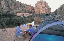
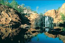
The main attraction is the one to the northeast Nitmiluk National Park With
- Katherine Gorge, Access from Katherine via Giles and Gorge Road, approx. 30 km, visitor center, helicopter tours, boat tours, canoe rentals
- Edith Falls, Approach via the Stuart Highway about 40 km to the Edith River, then 20 km to the east, swimming is possible directly at the campsite
The system of 13 gorges with corresponding pools invites you to swim and hike, the paths vary in length and difficulty. Best time to visit outside of the rainy season due to otherwise possibly flooded access roads, closed hiking trails and cloudy brown water in the pools. In the dry season, the national park is also a crocodile-monitored zone.
The Victoria Highway branches off to the west in Katherine and leads to Western Australia via Kununurra.
56 miles to Pine Creek
Pine Creek grew up through the gold rush, today it has around 250 inhabitants, previously there were over 1500, mostly Chinese prospectors. Can be visited: Museums (National Trust Museum in the telegraph station, Railway Museum at the old train stop), parts of the old mine area and the Enterprise Pit Mine Lookout with a great view of the full hole that the gold diggers dug in the 1870s. The Umbrawarra Gorge Nature Park is about 20 km southwest and offers a sandy beach at its water holes. Several hotels, motels and campsites.
Here goes the Kakadu Highway from, it connects the Stuart Highway on a southern route with the Kakadu National Park.
113 km to Adelaide River
The little place Adelaide River (200 inhabitants) was a stationing place for up to 30,000 Australian and American soldiers including a large hospital during World War II. A military cemetery with a lovingly tended garden has been preserved. There is a museum on the site of the former railway, and there is also an old railway bridge. Gas station, small shop, farm accommodation possible.
28 km to the junction for Batchelor
Shortly after Coomalie Creek, Batchelor Road goes left, which leads to the small town Batchelor and on to Litchfield National Park leads. As the gateway to the national park, Batchelor offers various types of accommodation, from B&B to hotels and bungalows. But that is also interesting Batchelor Institute of Indigenous Tertiary Education, a large college for Aboriginal and Torres Strait people - which means that there are many aboriginal cultural activities in the city, including this Coomalie Cultural Center with art market and cultural offerings.
41 miles to Palmerston
After 39 km there is another junction to the west that leads to Litchfield National Park, but on a later road it is only accessible with four-wheel drive and is often closed due to flooding during the rainy season.
The Stuart Highway is now becoming more and more "civilized", there are several streets to the right and left, compared to the outback it seems almost populated here. After 12 km goes to the right Armhem Highway from that to Kakadu National Park leads.
Palmerston is a young, rapidly growing satellite city of Darwin with appropriate infrastructure and only a few accommodations. Nevertheless, it is worth taking a detour there Howard Springs Nature Park: Picnic areas, also with BBQ areas, hiking trails, youth campsite, paddling pool for the little ones. There are bike paths all the way to Palmerston.
21 km to Darwin
As the capital of the Northern Territory with over 120,000 inhabitants from 75 nations, the international airport and large port Darwin also as Gateway to Asia designated. It offers numerous accommodations, restaurants, cultural offers and infrastructures that a traveler can use. However, there was always devastating destruction from cyclones, the last one - Cyclone Tracy - devastated almost the entire city. But tourists have to be less prepared for catastrophes than for a tropical climate with high humidity and heavy downpours from November to April.
security

- Roadtrains sind lang (bis zu vier! Anhänger), schnell (oft schneller als ein Camper) und können nur sehr schlecht bremsen. Auch auf den schnurgeraden Straßen im Outback kann ein Überholvorgang über die 60 Meter Fahrzeuglänge hinweg sehr lange dauern und der Roadtrain bedrohlich nahe kommen. Bei entgegenkommenden Wagen langsamer werden und an der linken Straßenseite kleben.
- Wildtiere - große wie Kängurus, Kamele, Wildpferde oder Emus zeigen keinerlei Respekt vor Fahrzeugen, insbesondere in der Dämmerung und Nachts queren sie einfach die Straße oder bleiben darauf hocken. Auch nett ist wenn man ein neben der Straße hockendes Tier erschreckt und es dann auf die Straße springt.
- Kleine Wildtiere wie Dingos, Schlangen oder harmlose Wallabees sind wild - egal wie süß sie aussehen. Bei einem vermuteten Angriff oder Unterschreitung der Fluchtdistanz beißen, boxen oder kratzen sie, im besten Falle sind sie auch noch giftig oder verpassen einem eine Infektion. Essbares wird gerne geklaut, füttern verbietet sich von selbst.
- Regengüsse behindern zunächst die Sicht, dann machen sie die Straßen zusammen mit dem darauf liegenden Sandfilm und Gummiabrieb glitschig und zuletzt kommen sie noch als Flutwelle quer über die Strecke. Überschwemmungen dauern zwar meist nicht lange (außer im tropischen Norden, da kann das sich auch über Tage hinziehen) aber wenn sie durchgehen sollte man weder im Weg stehen noch versuchen durchzukommen. Aus sicherer Position abwarten ist die beste Option. Die Schilder mit den Überschwemmungshöhen zeigen oft Skalen über zwei Meter Höhe - und das ist realistisch.
- Buschfeuer können jederzeit ausbrechen, wobei natürlich die Trockenzeit bzw. der heiße Sommer besonders gefährlich ist. Das Problem bei Buschfeuern ist sie aufgrund der wenigen Straßen nicht umfahren zu können und dass sie schneller sein können als ein Fahrzeug. Es gibt im Land ein wirklich gut ausgebautes Informationsnetz mit verschiedenen Warnstufen, das Beste ist sich vor Ort über Radio, Zeitung, Internet, Aushang und einen Smalltalk an der Tanke bzw. im Geschäft über die aktuelle Situation zu informieren. Und natürlich nicht in Bereiche fahren, in denen es brennt.
- Und bitte selbst kein Buschfeuer verursachen! Es gibt fast überall ausgewiesene Feuerstellen, die genutzt werden können (trotzdem danach vernünftig löschen) oder BBQ-Stationen, die kostenlos oder preiswert das Grillen des Steaks ermöglichen. Zeitweise herrscht totales Feuerverbot, auch das wird genügend ausgeschildert.
- The Sonneneinstrahlung ist nicht nur im Zentrum von Australien sehr stark, auch im Süden oder im tropischen Norden holt sich ein europäisches Bleichgesicht schnell einen Sonnenbrand. Das Tragen von schulterbedeckenden T-Shirts, langen Hosen, einem Hut und vor allem Sonnenschutz ab Stärke 30 aufwärts hilft.
- ...
literature
- Lonely Planet: Central Australia, Adelaide to Darwin. 2013 (6. Auflage), ISBN 1741046637 ; Taschenbuch, circa 340 Seiten (in Englisch). 17 Euro
- Hema.2.03 (Hrsg.): Adelaide to Darwin. Maßstab: 1 : 2 000 000. Dez. 2011 (2. Auflage), ISBN 1865003778 . circa 11 Euro