Plain of San Vittorino is a region of Lazio.
To know
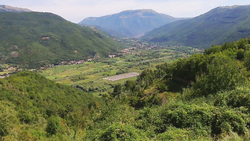
Piana di San Vittorino, Cotilia or Peschiera is a small plain ofcentral Italy in Sabina Rieti crossed by the Velino river. It is a humid area very rich in water and characterized by marked karst phenomena.
Geographical notes
La Piana is located along the course of the Velino, squeezed between the group of Terminillo to the north and the Monti del Cicolano South. It stretches east-west for four kilometers and is two kilometers wide. It constitutes a widening of the Velino valley, which narrows at the two ends of the plain: going up its course, towards the east, it narrows at Borgo Velino is Antrodoco, after which it enters the even tighter Gorges of the Velino, and to the west it narrows at Cittaducale and some hills south-east of Rieti, before entering the Piana Reatina.
Geological features
According to geographer Riccardo Riccardi, the grandeur with which karst erosion occurs in the plain of San Vittorino has no equal in all of Italy. In this area, sinkhole phenomena are common, which also involving houses and buildings can be very dangerous due to their suddenness. Currently 42 sinkholes are cataloged and monitored. The traces left by the sinkholes are called by the local canetre or canetroni, basins, wells, names that gave rise to their respective toponyms. The lakes of Paterno, Mezzo and Burino originated from sinkholes of this type.
The abundance of springs on the surface is an evident manifestation of a vast underground water circulation, which exerts a strong corrosive action on the travertine layer on which the entire plain rests, thinning it and forming underground caves inside it, which at times yield by making sink into the ground above.
Background
It takes its name from San Vittorino di Amiterno, who was martyred here in 96 AD by the emperor Nerva, hanging upside down on a sulfur spring. Historically, the plain was subject to frequent flooding by the Velino river, which caused serious damage agriculture and deposited stagnant water in the countryside which favored the spread of malaria. In the eighteenth century the problem was identified in the insufficient embankment of the river and in its tortuosity, but measures were taken only in 1839 when the Velino was removed from its historical site at the foot of the Terminillo and diverted to the center of the valley in a purpose-built straight artificial canal, 4.4 km long, 4.30 meters deep and 18.50 meters wide. But the encrusting power of the waters of the Velino made the bottom of its new bed rise rapidly, re-proposing the problem of overflows, and in the post-unification period the deforestation further worsened the situation due to the greater quantity of gravel that the mountain streams introduced into it. The problem was definitively solved through drainage works. [1]
Territories and tourist destinations
Urban centers
- Sant'Angelo castel - The Baths of Cotilia, an ancient Roman center, were frequented by the emperors Titus and Vespasian, who ended their days there.
- Cittaducale - Its historic center retains a beautiful medieval village; it was a bishopric from the early 16th century to 1818.
How to get
The plain of San Vittorino is served by important infrastructures; for those coming from Rieti and from Rome is the natural passage point to get around the Terminillo and reach theAbruzzo (climbing over the Apennines from Antrodoco via the Sella di Corno pass) or to reach the upper Velino valley (Posta, Amateur, Accumulate) and then pass the Apennines with the Passo della Torrita to reach Ascoli Piceno and the Adriatic Sea. For this reason, already in Roman times the plain was crossed by the Via Salaria, the consular road that connected Rome to the Adriatic via Rieti ed Ascoli Piceno.
By plane
- Rome Ciampino Airport
- Rome Fiumicino Airport
By car
- Today the plain takes advantage of the state road 4 Via Salaria, which like the ancient road connects Rome to the Adriatic; from it, to Antrodoco, the state road 17 departs for L'Aquila. In this section, the Salaria is still a road with a narrow carriageway, which follows a path that is not too different from that of the Roman consular, as the fast-flowing section ends in Santa Rufina and resumes only in Posta.
- Also to the west of the plain, between Rieti is Cittaducale, opens the Salto valley, which is crossed by the regional road 578, the main access road to Cicolano.
On the train
- The railway Terni-Rieti-L'Aquila serves the area with the stations of Cittaducale, Cotilia, Springs of Peschiera, Sant'Angelo castel and Canetra.
By bus
- Cotral bus lines [1]
How to get around
What see
The plain, which today is densely cultivated, was a center of attraction since ancient times, when the "mysterious" karst phenomena gave the area a strong religious value. Furthermore, since Roman times, the springs of sulphurous waters were used for therapeutic purposes.
- Remains of the ancient Cutilia, where it is possible to admire the archaeological excavations of Terme di Vespasiano and of the villa of Tito.
- Modern establishment of the Terme di Cotilia, open from June to October, allows you to take advantage of the therapeutic benefits of the waters and offers treatments such as baths, muds, inhalations and aerosols, as well as fountains from which to drink the sulphurous or ferrous waters.
.jpg/220px-Resti_della_Chiesa_di_San_Vittorino_(5870997830).jpg)
- Church of San Vittorino - Founded in the fourteenth-fifteenth century on the remains of a pagan temple dedicated to the water nymphs, enlarged between 1608 and 1613, it was once one of the most important churches in Cittaducale, but it had to be abandoned in the nineteenth century when the ground on which it was built began to sink. Even today the church continues to progressively sink; an underground spring gushes out in the middle of the central nave and the water flows through the door of the building into the surrounding countryside. Its suggestiveness meant that a surreal scene from the arthouse film was shot in this church Nostalgia by Andrei Arsen'evič Tarkovskij (1983).
- 1 Lake of Paterno (to Vasche di Castel Sant'Angelo). Basin of karst origin, originating from a sinking of the ground (sinkhole, of which it represents one of the most exemplary cases, has an oval shape and small dimensions (150x190 meters, diameter of 204 meters, but is very deep (almost 54 meters). from an underground water source; the water drains through cracks in the limestone rock.
- It is located in the hamlet of Vasche and takes its name from the hamlet of Paterno, which is located at 600 m a.s.l. upstream of the lake.
- A few hundred meters from that of Paterno there are two other smaller lakes, also of karst origins: Lake Mezzo and Lake Piccolo, also known as Pozzo di Burino.
- The lake is suitable for bathing, fishing and scuba diving. The shores are characterized on one side by woods and reeds, on the other by a small equipped beach. Nearby are the ruins of the Roman baths.
- The date of the sinking that gave rise to the lake is unknown and very ancient. The lake already existed in pre-Roman times, when the Sabines attributed a great religious value to it, so much so that they had consecrated it to the goddess Vacuna and made sacrifices there. : Even earlier, as handed down by Macrobius, the Pelasgians made peace with the Aborigines near the lake, dedicating a chapel to Dis Pater and an altar to Saturn.
- The religious value attributed to it was due to the occurrence of phenomena considered mysterious: it is hypothesized that the Pelasgians may have witnessed the sinking of the lake and gave rise to the myth. The Latin authors also report that in the middle of the lake stood a floating island (still visible at the beginning of the nineteenth century and now disappeared), covered by thick vegetation, which perhaps as a result of karst phenomena moved frequently, disappearing and reappearing:
- Also because of its symbolic and religious importance, the Rieti scholar Marco Terenzio Varrone placed theUmbilicus Italiae (the navel of Italy), an indication that is reported by other contemporary authors; in the following centuries the center of Italy was traditionally located in Piazza San Rufo a Rieti.
- A few days after the Marsica earthquake of 1915, on January 31, there was a sudden drop in the water level, of about four meters, and a series of landslides, which lasted about two months. At their end, the depth of the lake increased by ten meters.
What to do
At the table
Safety
Other projects
 Wikipedia contains an entry concerning Plain of San Vittorino
 Commons contains images or other files on Plain of San Vittorino