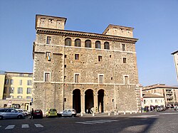
| Terni | ||
 | ||
Coat of arms | ||
| Salutation | Interamna Nahars | |
|---|---|---|
| State | Italy | |
| Region | Umbria | |
| Territory | Terni | |
| Altitude | 130 m a.s.l. | |
| Surface | 211.90 km² | |
| Inhabitants | 110.432 (2019) | |
| Name inhabitants | Terni | |
| Prefix tel | 39 0744 | |
| POSTAL CODE | 05100 | |
| Time zone | UTC 1 | |
| Patron | Valentine's day | |
Position
| ||
| Tourism site | ||
| Institutional website | ||
Terni is a city of Umbria.
To know
Geographical notes
Terni rises on the banks of the Nera and Serra rivers, in a vast and fertile basin surrounded by the Umbrian-Marche Apennines and the Sub-Apennines Lazio, in the southern part ofUmbria.
When to go
The city enjoys a typical Mediterranean climate, mild and comfortable in spring and autumn. The rainiest seasons are spring and autumn, mainly in the months of November and April. Summer is hot, humid, muggy and basically dry, while winter is cold and rainy, but with significant peaks of cold and interspersed snow phenomena of a certain consistency. In general, the climate is quite windy as the winds decrease in intensity as they meet the neighboring mountains.
Background
Terni has pre-Roman Umbrian-Sabine origins, as evidenced by the numerous finds preserved in the archaeological museum of the former Siri-Chaos area. In Roman times it became part of the municipality of Interamna Nahars and walls and a amphitheater, whose remains are still visible next to the cathedral.
During the first centuries of Christianity he became bishop of Terni Valentine's day, protector of lovers, whose remains are still venerated today in the basilica on the hill just above the city center.
The sanctuary of San Francesco and the church of San Salvatore.
In the years following the unity ofItaly Terni developed its industrial vocation by exploiting the waters of the Black he was born in Velino. In a few years the large steel mill, the Arms Factory and other impressive industrial complexes were built.
How to orient yourself
How to get
By plane
- 1 Sant'Egidio Airport (Perugia airport), ☎ 39075592141.
By car
Terni is 80 km from Perugia, about 100 km from Rome, about 240 km from Florence and about 530 km from Milan.
On the train
Terni has a railway station:
- 2 Terni station. On the lines Rome – Ancona, Terni - Sulmona, Terni - Sansepolcro
How to get around
What see
Events and parties
What to do
Shopping
How to have fun
Where to eat
Where stay
Safety
How to keep in touch
Around

- 3 Marmore Falls (seven km from the city center, they can be reached by bus 7 or 21), ☎ 39 0744 62982, fax: 30 0744 362231, @[email protected].
 9€.
9€.  Variable depending on the season. Roman work of hydraulics of the third century, commissioned by the consul Curio Dentato, is a controlled flow waterfall among the highest in Europe. The waterfall has a total height difference of 165 m, divided into three jumps.
 - 4 Piediluco lake (From Terni (~ Km 18): Statale 79 towards Rieti or Bus n.24), ☎ 39 0744 368225, @[email protected].
- 5 Mummies of Ferentillo.
- 6 Narni Underground.
- 7 Sant'Erasmo.
- 8 Cesi.
- 9 Stroncone meadows.
- 10 Monsters of Bomarzo.
- 11 Dun Wardrobe Fossil Forest.
- Carsulae, "U.Ciotti" Visitor and Documentation Center in Carsulae Strada di Carsoli, 8, ☎ 39 0744 334133. Carsulae was an ancient city from the Roman era.
- 12 Orvieto Underground.
Itineraries
- Via Carolingia - European itinerary that crosses the places traveled by the court of Charlemagne between the 8th and 9th centuries to travel from Aachen to Rome, where Pope Leo III crowned the Carolingian sovereign emperor of the Holy Roman Empire on Christmas night in the 19th century.

