
The Piton de la Fournaise (2631 m), easy for the locals "Le Volcan", is one of the most active volcanoes in the world and is located in the southeast of the island Reunion in the Indian Ocean. The mountain is part of the "Inner Zone" of the 2007 established Reunion National Park and has been part of the UNESCO World Heritage Site.
places
| location | ||
| ||

The volcanic region is as good as uninhabited. The closest places are 1 Le tampon and 2 La Plaine-des-Palmistes and are located on the plateaus of the interior of the island to the west of the volcano.
background
The French fournaise translates into German as oven or also Glutofen (Esse), where Piton stands for mountain peak.
The Piton de la Fournaise occupies the south-eastern third of the island of Réunion. The outer caldera of the volcano is called Rempart, the inner collapse crater with the volcanic cone is similar to the lunar landscape Enclos Fouqué. The inner caldera is open to the east in a horseshoe shape and measures approx. 13 km in east-west direction and 9 km from north to south. Their age is estimated to be around 5000 years. The "Enclos Fouqué" is clearly delimited from the surrounding area by an outer crater rim up to 200 m high and is almost completely free of vegetation. The landscape is shaped by the exposed volcanic rock and the volcanic ash from the most recent volcanic eruptions. In the center of the inner caldera, the summit cone of the volcano rises around 400 m above the crater floor of the "Enclos Fouqué". At the summit is the two-part main crater with the large and active summit crater "Dolomieu" and the smaller summit crater "Bory".
Volcanism
 Lava flows: AA lava over Pahoehoe lava | 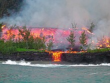 Outbreak 2005 |
 Pahoehoe lava |  AA lava ("Lave en gratons") |
 "Pele's Hair" |  "Lave cordée": Seillava (Pahoehoe lava) |
For general information on volcanism on the island, see also the articles Reunion and Piton des Neiges.
Geologically it is the island of Réunion with its active volcano Piton de la Fournaise and the extinct volcano Piton des Neiges around a single huge shield volcano. It owes its creation to that Hotspot volcanism similar to that of the island Hawaii. Characteristic of this type of volcanism is deep and stationary thin-flowing lava rising from the earth, which first cuts a hole in the earth's mantle like a welding torch and then creates a volcano from the sea floor.
The rise of the island of Réunion from the sea floor is estimated to have been around two to three million years ago, with the end of the volcanic activity of the neighboring volcano Piton des Neiges around 12,000 years ago. The only active volcano on the island is now the Piton de la Fournaise, the beginning of its activity is estimated to be around 500,000 years ago.
Due to the thin liquid lava from the deep interior of the earth, the eruptions of the Piton de la Fournaise are considered to be comparatively harmless and are therefore an extremely popular attraction for the locals and also for the volcano tourists who have come from all over the world. The eruptions essentially consist of lava emission accompanied by smaller explosions. Ash clouds rarely arise Pele's hair sometimes arises.
lava
The hotspot volcanic simus of the Piton de la Fournaise (similar to the one on Hawaii) there are several types of ejected lava:
- The Pahoehoe lava is extremely hot (around 1100 to 1200 ° C) and therefore thin and almost smooth on the surface. The name comes from the Hawaiian language and means something like "silky river": After cooling, the lava gets a shiny, satin-like surface.
- The Aa lava, also lava, is much cooler at a little over 1000 degrees Celsius and therefore tougher and it also flows more slowly. Often already solidified or slaggy pieces of rock are carried along on the surface, with sharp-edged blocks and clods the lava looks like plowed up arable soil on its surface after cooling. The name of the lava is traced back to the sound made by a person walking with bare feet over the solidified lava. The name is also of Hawaiian origin, but is also understood internationally.
- Pele's hair, the name is derived from the Hawaiian volcano goddess Pelé, is sometimes ejected from the volcano in the form of lava fountains or lava cascades, it is the name for hair-shaped volcanic glass. The very finest web is broken up by the wind and sometimes carried many kilometers away. The obsidian-like hard and extremely fine needle-like fibers, when deposited in the grass, are a threat to the stomachs of grazing cattle. The cows in the surrounding area are therefore locked in the barn in the event of an outbreak reported by the observation centers. The glass gets caught in the protected rock corners of the crater and can also be found later by the visitor, it has the grip of fine cactus spikes.
- Pele's tears are drops of lava frozen in the air.
Recent volcanic activity
The volcano often erupts several times a year, the last time in July 2017. Nevertheless, you still need a bit of luck to get the right time to visit and experience the fire spectacle:

- 1998: After a six-year period of complete rest, a new active phase begins in spring: the number of earthquakes increases from the beginning of the year, and the magma chamber under the volcano fills up. Shortly before the first eruption, more than 1000 earthquakes per hour are registered, followed by the first major eruption on March 9th. Since then, the volcano has been active two to three times a year, with an eruption in September 2004 being particularly spectacular.
- in the April 2007 After one of the largest eruptions of the last hundred years, the magma chamber of the main crater Dolomieu, which was filled up to then, empties completely, the crater floor sinks by more than 300 m below the crater rim, it is thus still below the area surrounding the crater floor of the inner caldera "Enclose Fouqué" ( approx. 2200 m). Because of the unstable conditions, the area at the crater rim is completely closed to visitors. The lava flows reach the sea, numerous dead fish on the sea surface arouse the interest of marine biologists, who are able to identify some previously unknown fish species.
- September 2008: A small lava pond forms on the floor of the Dolomieu crater, which is fed from a furrow on the west side of the crater, accompanied by several smaller earthquakes.
- October 14, 2009 a swarm of several hundred smaller earthquakes shook the summit.
- November 5, 2009: Renewed volcanic activity, the following eruption with several lava flows is now taking place south and east of the Dolomieu summit crater and further down near the coast, the lava flows are also clearly visible from the coastal road, the situation remains unstable.
- December 14, 2009 short six hour eruption accompanied by minor earthquakes.
- January 2010: 10-day volcanic eruption, the crater rim on the summit, which is now considered safe, will then be reopened for visitors.
getting there
In the street


The approach is via the als "Route du Volcan" signposted and approx. 35 km long volcano road, it branches into Plaine des Cafres from the RN3 (island crossing from Saint-Pierre to Saint-Benoît) from. The approach route, which has been largely tarred since 2004, was created from 1957 to 1968 and leads via Bourg Mourat (with the volcano museum Maison du Volcan) first through an almost alpine pasture landscape, before then the bizarre volcanic landscape of the Plaine des Sables (in the outer caldera) follows. The route then becomes a gravel road.
The car park is at the end of the Route du Volcan "Pas de Bellecombe" at the crater rim (21 ° 13 ′ 31 ″ S55 ° 41 ′ 4 ″ E) with a viewing platform over the inner caldera. There is now (as of March 2017) a small kiosk with a toilet at the parking lot.
Shortly before the parking lot, a road branches off to the left to the mountain hut Gite du Volcan from.
There are always worthwhile viewpoints along the entire route.
Until the completion of the "Route du Volcan", the Piton de la Fournaise could only be reached via a journey of several days, similar to an expedition.
Tourist Attractions


Enclos Fouqué (inner caldera)
- The 1 Bory Crater is the western and at 350 m long and 200 m wide the smaller and flatter of the two main craters on the summit cone. The highest point of the volcano is also on the western edge of the crater (approx. 2,631 m). The name is derived from the French naturalist and scholar Jean Baptiste Bory de Saint-Vincent ab, who carried out observations on the volcano in 1802 and made a first map of the lava flows. The crater already existed when the island was first settled.
- The 2 Dolomieu crater (cratère Dolomieu) is the eastern and active main crater on the summit cone and with a length of 1000 m (E-W) and currently (2010) about 700 m in diameter the significantly larger, deeper and also younger of the main crater, it is named after the French geologist and mineralogist Déodat ridge of the Dolomieu (1750-1801). The crater was created in 1791 and was at the beginning a 200 m wide and 40 m deep hole.
- There are numerous smaller secondary craters throughout the volcanic area.
- 3 Formica Leo (Ant lion), originated in the 18th century and near the descent on the crater rim.
- 4 Chapelle de Rosemont, an accessible cavity several meters in size, emerged from a gas bubble in the liquid lava. The cave is on the way to the crater rim.
All over the area there are various forms of frozen ones Lava flows (Fladenlava, Wulstlava, Seillava or Stricklava) to visit. The flowing of the still hot lava under the already cooled surface also resulted in numerous lava caves.
Rempart (outer caldera)
- Commerson Crater older crater, located on the access road and easily accessible from a parking lot.
- 5 La Plaine des Sables, also called "Plaine de Lune": a lunar-like desert made of volcanic ash and volcanic sand with dimensions of approx. three by five kilometers. The "Route du Volcan" approach road runs right through it.
activities

hike
Only access To the inner caldera "Enclos Fouqué" with the volcanic cone and the two summit craters, visitors can descend on the steep crater rim near the parking lot Pas de Bellecombe (at 2,311 m). With this only possible descent (approx. 100 mH, 20 minutes), the entire area is also easily controllable and, depending on the given hazard situation at the volcano, can also be easily blocked by the responsible authorities. Depending on the dangerous situation on the volcano, the circumnavigation of the two summit craters is released or not, the instructions on the signs on the descent must be observed. Access is free of charge.
The whole Ascent to the summit area of the volcanic cone runs on a technically not difficult route in pure hiking terrain without any particular risk of falling (with the exception of the immediate crater rim) and is provided with white markings on the stones every five meters. However, walking on the uneven volcanic rock is in large parts a bit "impassable". The walking time for the way to the edge of the volcanic cone (approx. 2,500 m) should be calculated at least four hours. Depending on the length of stay on the road, eight to ten hours should be planned for the total length of stay. Allow around two additional hours to go around the summit region. The tour ends after the way back from the volcanic cone with the counter-climb to the upper crater rim of the "Enclos Fouqué", which may be quite strenuous for one or the other.
At beautiful weather Pay attention to the strong solar radiation at high altitude and, as a result, strong heating of the dark volcanic rock. Sufficient sun protection and enough drinking liquid should be carried with you.

Particular attention should also be paid to: Rain and fog are easily possible all year round from the afternoon at the latest, the result is then a damp stretch of road and sometimes dangerously smooth basalt stones. In addition to the necessary sturdy footwear for the sometimes extremely sharp-edged, young basalt rock and a water-repellent anorak (xxx-Tex), a warm sweater should also be carried with you because the temperature drops quickly in rainy weather. Due to the usual worsening weather in the afternoon, a start as early as possible in the morning is recommended.
The difficult one can be the most dangerous for hikers Orientation in fog become: The whole route runs without any special landmarks in a vegetation and soil-free ascent path on rocky volcanic terrain. Since the route is often freely chosen by visitors in the area when the weather is good and visibility is good, there is no well-worn path for large parts of the ascent of the crater on the fresh volcanic rock and therefore no clear climbing tracks. In fog with a diffuse view and the white waymarks that are not always easy to recognize, orientation can quickly become difficult if you stray.
For more general information on hiking equipment, see the article Rockclimbing.
Sightseeing flights
The volcanic region is also an extremely attractive destination of one Sightseeing flight (Helicopter and ultralight), the prices are around two hundred euros per person. As a rule, the weather situation worsens significantly during the day, so the time of departure should be selected as early as possible in the morning. In the event of eruptions, particularly spectacular sightseeing flights in the helicopter at night are also offered.
Kitchen and accommodation
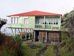
The only restaurant and accommodation in the volcanic region is the comparatively comfortable mountain hut "Gite du Volcan". It consists of the main building of the inn and a few adjoining buildings for overnight stays with a fairly generous room layout.
Prior reservation is mandatory in the Réunions mountain huts. This can be in Saint-Denis (also via the Internet):
During the main travel season, reservations must be made several weeks or months in advance.
Directions for the hut via the "Route du Volcan" see section In the street in front.
climate
| Brief information | |
| Phone code | 262 and the last 9 place digits |
|---|---|
| Time zone | UTC 4 |
| Emergency cell phone | 112 |
| Ambulance | (0) 262 20 20 33 |
| Cyclone warning | (0) 897 65 01 01 |
For general information on the island climate, see the article on Reunion.
The best season for a hike to the Piton de la Fournaise is the Winter on Reunion, those are the months from May to October with more moderate temperatures and less rainfall. The mornings usually start out sunny, but by noon at the latest it draws in from the east coast. The mountain regions in the interior of the island are often foggy in the afternoon and it rains until the evening. In the night it usually clears up again.
The approach to the volcano is from the west side, which is clearly favorable in terms of weather: the route lies in the lee of the mountain for the trade winds of the Indian Ocean that hit the island from the east. The mean daily precipitation in the west of the mountain is 200 mm per day, but there are daily extremes from 500 mm up to 1 meter per day possible. On the east side of the mountain, the rainfall is significantly higher, the annual rainfall here reaches around 12 meters.
With regard to the hazard from suddenly possible fog, see the explanations in section hikes. If you want to hike in the region during the wet season, you should definitely refer to the weather reports and severe weather warnings / Cyclones respect, think highly of.
The last snowfall at the summit was recorded on two days in August 2003.
literature

- Geographical University of Heidelberg (Ed.): Île de la Réunion (pdf). 2006, Final report on the big excursion; 149 pages; PDF (German). Current and comprehensive information on the history, geology, geography, volcanism, population and culture of the island.
cards
- Geographic National Institute (Ed.): Piton de la Fournaise 1:25 000 (for hikers), 4406 RT. Paris, Carte de Randonee topographique Top 25 (in French). Approx. € 11, available on site and at French airports
Web links
- The Réunion National Park on the Internet: www.reunion-parcnational.fr (only French)
- Official tourism site for the south of Réunion: sud.reunion.fr (currently only in French)
- Official tourism site for all of Réunion: www.reunion.fr
