 | |
 | |
| Puy-de-Dôme department | |
| Capital | Clermont-Ferrand |
|---|---|
| Residents | 659.048 (2018) |
| surface | 7,970 km² |
| no tourist info on Wikidata: | |
| location | |
 | |
Puy-de-Dôme is a department in the French former region Auvergne (since 2016 Auvergne-Rhône-Alpes with serial number 63. The department borders (clockwise, starting in the north) on the departments Allier, in the east Loire, in the south to the départements Haute Loire and Cantal and in the west Corrèze and Creuse.

Regions

places
- 1 Clermont-Ferrand


 in the Wikidata database") - Prefecture (administrative seat) of the department. City of art and history, cathedral, town hall, basilica, museums, parks, Place de Jaude, Amboise fountain, mansions of the old Montferrand, Chanturgue plateau.
- Prefecture (administrative seat) of the department. City of art and history, cathedral, town hall, basilica, museums, parks, Place de Jaude, Amboise fountain, mansions of the old Montferrand, Chanturgue plateau.

- 2 Besse-et-Saint-Anastaise - Green holiday resort, beautiful village, church, Pavin lake and winter sports resort

- 3 Ambert -


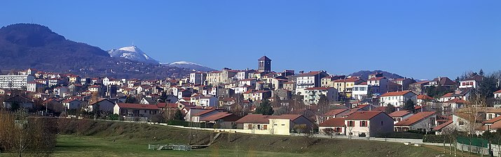
Clermont-Ferrand

Besse-et-Saint-Anastaise

Ambert


- 4 Beaumont -
- 5 Chamalières
 -
- - 6 Cournon-d'Auvergne -


Beaumont

Chamalières

Cournon-d'Auvergne


Issoire

Riom
Thiers


Other goals
background
geography
The department is characterized primarily by its volcanoes, including the Puy de Dôme, the summit of which reaches an altitude of 1,465 meters. It is the highest point of the Monts-Dôme chain.
In addition, Vulcania, the European Volcano Park, has been offering a playful opportunity to understand the history and functioning of volcanoes since 2002.
This volcanic relief also offers many lakes for fishing or other activities, such as the Pavin and Servière lakes. Because of its proximity to the regional prefecture, Lake Aydat is more the Sunday spot for Clermont residents. But it is also a place where you can practice water sports. In general, the department benefits from beautiful nature, especially the Sioule gorges.
The mountain Puy de Dôme. who gave the department its name, is known among cycling fans as a stage of the Tour de France.
language
getting there
By plane
Clermont-Ferrand has its own regional airport called Aulnat.
By train
There are rail connections to Paris, Lyon and the south of France.
mobility
Tourist Attractions
Castles and Romanesque churches are in abundance here, with the castles of Murol, Saint Saturnin and Parentignat (near Issoire) worth a visit, especially the churches of Saint Nectaire / Orcival are of historical importance.
activities
This region is the "paradise for outdoor enthusiasts", which is suitable for both summer and winter sports.
It is famous for its countless walking and hiking trails. The well-signposted hiking trails lead through the Puys chain, the Cezallier mountains, the Sancy mountains and the Livradois forest, where beautiful views are offered around every corner. The Vallee de Chaudfour and Saint Nectaire / Murol regions are of particular interest to hikers with a taste for wildlife and history.
Cyclists will also get their money's worth, and climbing and air sports enthusiasts will find information on numerous institutions dedicated to these sports in the local tourist offices in every major city.
Fishing, kayaking / canoeing is extremely popular in the departments with more than 7,500 km of river length. Especially the Allier at Issoire and Vic le Compte as well as a multitude of lakes such as Lac Chambon, Lac Pavin and Lac d'Aydat are particularly noteworthy.
For both downhill and cross-country skiers there are three interesting villages in the Sancy Mountains, Le Mont Dore (north side) and Superbesse (south side), both of which are around 1000 m high. The skiers are carried by gondolas to just below the summit of the Puy de Sancy at an altitude of over 1850 m. There is a connection between the two ski areas that will satisfy even experienced skiers. Outside the school holidays there are practically no queues for the lifts. La Bourboule and the surrounding landscape offer cross-country skiers excellent conditions with challenging trails.
The area is also famous for its thermal springs and spas that offer treatments and therapies for many ailments - three of which are Le Mont Dore, La Bourboule and Saint Nectaire.
Regular events
- In October, the town of Durtol hosts the apple pie festival
kitchen
- The one from the region of the Livradois-Forez Natural Park Fourme d'Ambert is a blue cheese made from cow's milk, with controlled designation of origin (AOC). The production can be traced back to the 8th century. In the house of the Fourme d'Ambert in the old town of Ambert you can find out about its history and the various production steps.
- The cheese Saint-Nectaire is a cow's milk cheese with a creamy, soft consistency and a slightly nutty taste. It has a controlled designation of origin (AOC) and is produced in the Sancy massif. In the House of Cheese in Saint-Nectaire you can taste the cheese, discover a maturing cellar and learn interesting facts about its history, production and aging.

Fourme d'Ambert

Saint-Nectaire


nightlife
security
climate
Due to its location within the continent and its rugged topography, perpendicular to the prevailing moisture flow from the west, it is an area with sharp climatic transitions, from mountain to plain and from oceanic to continental, creating diversity and contradictions.
The amount of precipitation varies from one of the driest to the wettest places. The mountains in the southwest (Sancy, Cézallier) are lush and snow-covered, while the Limagnes in the center is shielded by a strong blow-dryer effect. The share of storms in total precipitation is increasing. To the east, the foehn disappears while the other barrier formed by the mountains Livradois and Forez draws closer.
The Puy-de-Dôme is one of the stormiest departments in France: thunderstorms are very frequent in summer (heat thunderstorms), sometimes violent. This can be explained by the relief of the department, where plateaus such as hills, domes or volcanoes attract lightning. The geology of the Auvergne plateaus, the ferrous and volcanic plateaus of the department also play a role. Likewise, the influence of air masses: humid and continental air from the Auvergne, hot air from the south of the Massif Central, cool and slightly humid air from the Atlantic.
The average temperature difference between the warmest and the coldest place is 8 ° C, in winter the plains are sometimes colder than the mountains due to inversion weather conditions.
trips
literature
Web links
http://www.puy-de-dome.pref.gouv.fr/ - Official website of the Puy-de-Dôme department