| Resia | ||
 | ||
| State | Italy | |
|---|---|---|
| Region | Friuli Venezia Giulia | |
| Territory | Tarvisian | |
| Altitude | 492 m a.s.l. | |
| Surface | 119.31 km² | |
| Inhabitants | 1.021 (2016) | |
| Name inhabitants | Resiani | |
| Prefix tel | 39 0433 | |
| POSTAL CODE | 33010 | |
| Time zone | UTC 1 | |
| Patron | Santa Maria (August 15) | |
Position
| ||
| Institutional website | ||

Resia (Resije in Resian, Rezija in Slovenian, Rèsie in Friulian) is a scattered municipality of the Friuli Venezia Giulia.
To know
Resia is a town scattered in the homonymous valley; municipal seat is the inhabited area of Meadow.
Geographical notes
The municipal seat of Prato is 25 km from Tolmezzo, 27 from Pontebba, 28 from Gemona del Friuli, 51 from Tarvisio.
Background
The origins of Resia are linked to the settlement of its population in the valley, which dates back to the 7th century. The Resians are the descendants of those populations of Slavic lineage who came to Italy following the Avars and the Lombards and who, abandoning nomadism, took up residence here. Once isolated between the Musi mountains to the south and the imposing Canin massif to the east and north, Resia represents an island of language and traditions extremely important for culture. The singular language, the Resian language recognized by Unesco that is spoken there has been and still is the subject of many studies, thus preserving and handing down traditions (customs, songs, dances, ceremonies) of great interest.
From the historical point of view, being Resia subject to the jurisdiction of the Abbey of Moggio, it followed the events over the centuries. It was of some importance under Venetian rule for the defense of the Carnizza and Guarda saddles that allow you to reach the valley from the Isonzo in Slovenia. For this purpose there was the presence of a military garrison in the valley with fortifications in Stolvizza and San Giorgio. In 1976 the town was devastated by the Friuli earthquake, which caused enormous collapses and damage.
How to orient yourself
Neighborhoods
The municipal territory is made up of the centers of Gniva (Njiva), Oseacco (Osoane), Prato (Ravanca) (municipal seat), San Giorgio (Bila), Stolvizza (Solbica), Uccea (Učja).
The municipal seat is in the town of Prato.
How to get
![]()
- 1 Friuli-Venezia Giulia Airport, via Aquileia 60 (in Ronchi dei Legionari), ☎ 39 0481 773224.
- 2 Marco Polo Airport in Venice, viale Galilei (to Tessera), ☎ 39 041 2609260.
- 3 Verona Airport (Catullus), Boxes of Sommacampagna, ☎ 39 045 8095666, @[email protected].
By car
 The valley can be reached from the Carnia-Tolmezzo exit of the A23 motorway in the direction of Tarvisio arriving after about 10 km in Resiutta and following the crossroads for Val Resia.
How to get around
What see
The 1976 earthquake caused serious damage to the building heritage of the villages in the valley, mainly made up of the typical Alpine rustic houses. There are few examples of rural buildings with wooden arches and balconies in Stolvizza and in the locality of Coritis.
Characteristic are the ancient sundials located mainly in the mountain pastures. There are numerous external frescoes, among which the eighteenth-century one of the Lettig house in Stolvizza is noteworthy.
There are also furnaces and mills located almost everywhere along the watercourses of the Resia stream.
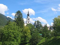
- Church of Santa Maria Assunta. It preserves a wooden statue of 1535, the work of Giacomo Martini. The church tower, which shows the characteristic onion terminal added in 1824, is probably of eighteenth-century origin.
- Church of San Vito (to Oseacco). It dates back to 1860; the apsidal part with the mosaic was saved from the earthquake Saints Vito, Modesto and Crescenzia made by the Mosaic School of Spilimbergo.
- Church of San Carlo Borromeo (in Stolvizza). The previous church was destroyed in 1746 by a flood and rebuilt further south in 1769. The building has a rectangular plan with three naves with ceiling frescoes, as well as the apse. The neoclassical facade has an oval rose window with a cross inside.
- The bell tower has a rectangular belfry with mullioned windows.
- Inside it preserves an altarpiece depicting Saint Valentine, Saint Bartholomew and Saint Anthony of Padua made in 1866 by the painter Domenico Fabris. In the apse the fresco Resurrection of Christ it is the work of 1924 by Giuseppe Barazzutti from Gemona. Other later works are due to Domenico Forgiarini.
- Chapel of Mount Kila (in the locality of Uccea). It is part of the tradition of the valley to build votive chapels, usually near intersections or forkings of the paths, in the mountain woods. It differs from other constructions of this type for its considerably larger dimensions. It stands in an inaccessible area and has a rectangular plan, a gable roof and stone walls, partly dry, partly blocked with mortar. Tradition has it that it was dedicated to Santa Barbara.
- Versa in a state of decay, and for this reason it is included in the number of historical memories to be protected, as part of a broader project of recovery of the local heritage.
Events and parties
What to do
Shopping
How to have fun
Where to eat
Moderate prices
- 1 Osteria Alla Speranza, Via Prato, 3, ☎ 39 0433 53057.
Where stay
Average prices
- 1 Alle Alpi hotel restaurant bar, via San Giorgio 2, ☎ 39 0433 553912.
Safety
How to keep in touch
Post office
- 4 Italian post, via Roma 15.
Around
- Tarvisio - It has the particularity of being part of the catchment area of the Danube and the Black Sea: in fact the river Slizza, which crosses Tarvisio, flows into the Gail, a tributary of the Drava which in turn flows into the Danube. Another peculiarity: on Monte Forno there is the triple frontier, where the boundaries of Italy, Austria is Slovenia The city is a center of summer and winter tourism, and is in fact the capital of the eastern area ofFriulian Alpine Arch.