
The Route Napoléon / "Nationale 85" leads from Grenoble above Gap and Sisteron to Cannes resp. to the French Riviera.
background

Already at the time of the "Ancien Régime" the traffic connection between the French Riviera above Grasse and Digne-les-Bains to Grenoble expanded. She became known because she was from Napoleon I. on the occasion of his return from exile Elba to Paris was mastered in a very short time at walking pace. Since this advance has been compared to the flight of an eagle, "from church tower to church tower", it is adorable Eaglesymbol the place-name signs of the Route Napoléon localities.
The road was paved in 1927/32, expanded to provide a year-round connection from the Alps to the Mediterranean, and was given the name Route Napoléon, meanwhile, the National 85 declassified over longer stretches and received new names in sections (D1085, D4085 and D6085). Out of the area Geneva - Grenoble the route is a popular route to the French Riviera through the mountains of Haute-Provence.
From the point of view of travelers from German-speaking countries, the route from north to south to the Mediterranean is described, knowing that Napoléon's route from landing at Golfe-Juan in the opposite direction to Paris was completed in an express march.
history
Landed with 1200 loyal followers Napoleon I. after his return from exile on the Mediterranean island Elba in Golfe-Juan at Antibes and marched north in a hurry to avoid skirmishes with his opponents.
On March 2, 1815, Napoléon broke off with his troops Cannes up into the mountains, in four daily stages the troops reached the friendly Sisteron and on the same day Gap. The village was already after the sixth day's stage Laffrey shortly before Grenoble reached, after a discussion with the opposing troop commander on the "Prairie de la Rencontre", the "field of encounter", his troops joined him and he was already on March 7th with jubilation in Grenoble move in.
After the advance into Paris and the invasion of the Tuileries on March 20, the broke Reign of the Hundred Days at. After the Emperor Napoléon made his personal Waterloo had experienced, his career ended in exile on the island Saint Helena in the South Atlantic a few years later.
preparation
Depending on whether the route is to be covered by bike, motorbike, car or mobile home, the travel preparations and the way forward are very different.
getting there
From the German-speaking countries, the journey is usually made via Grenoble, the city can be over Lyon and the A43 / A48 or from Geneva from over the A41 - Autoroute blanche and Chambery can be achieved.
Drive
On the connecting road from Grenoble to the French Riviera A very high volume of traffic must be expected, according to the good standard of construction it is best to use a motor vehicle, car, motorcycle or mobile home for the journey. Due to the heavy traffic, it is not advisable to ride a bike.
According to the route from the German-speaking countries, the route in north-south direction is compiled here, Napoléon and his troops made the route on his return from the island in the Mediterranean Elba in the opposite direction, of course.
Grenoble - La Mure - Corps


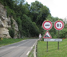
From the Grenoble southern bypass (Rocade Sud) the route initially leads on the feeder that has been developed as an expressway to Vizille, behind the village begins the slope, which is considered to be very accident prone. The 600 meters in altitude from Vizille (approx. 300 m) to Laffrey (910 m) are covered with inclines of 12 - a maximum of 18% for a short distance. The ascent in north-south direction is partly double-lane, which allows safe overtaking. The descent in the south-north direction is closed for cars and vehicles over 8t after several serious car accidents with brake failure, there is an altitude limit of 2.60m.
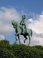
At Laffrey you get to the level with the 1 Prairie de Rencontre: This is where Napoleon's troops and those of his opponents met, Napoleon allegedly entered the royal troops with the words "If there is one among you soldiers who wants to kill his emperor, here I am!" across from. After some hesitation, shouts of "Vive l'Empereur - long live the emperor" made it clear that the opponents were joining Napoleon's troops. A large equestrian statue of Napoléon commemorates this episode.
At 2 Laffrey well worth a visit to the Quatre Lacs, the four lakes on a high plateau. The load from the north Lac Mort, the Grand Lac de Laffrey (actually the largest of them) who Lac de Petichet and the Lac de Pierre-Châtel for water sports and hiking (or in the privately owned Lac de Pierre-Châtel, swimming is prohibited by the owner). In the area of the lakes it is possible to spend the night in several campsites with lake access.
Next will be 3 La Mure crossed. The village is the terminus of the narrow-gauge railway Chemin de fer de la Murewhich of La Mure in countless hairpin bends and tunnels to the west via Notre-Dame-de-Commiers along the lake of the same name and the Drac river down to the Saint-Georges-de-Commiers SNCF train station. After a rock fall in 2010, the museum railway is currently no longer in operation, apparently the financing of the repair work is not secured.
In La Mure is this Château de Beaumont from the 15th century, the neo-Romanesque-Gothic 4 Notre-Dame de l'Assomption from 1890 and the imposing town hall from 1892.
At 5 Le Pont skin the route crosses the river on a bridge La Bonne. Now the route rises east of the i.a. Saint-Pierre-de-Méaroz dammed river Drac further to corps slightly on. Shortly before Comps you can see the dam Barrage du Sautetwho have favourited the Drac for Lacde Sautet accumulates.
Corps - Gap


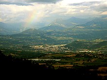
The locality 1 corps with its 500 inhabitants is located at 920 m, opposite the dammed river Dracwhich one here the Lac du Sautet forms, the mountain range of the Obiou. At the Lac du Sautet can be bathed and practiced water sports in 1 Camping du Lac du Sautet can be spent in the vicinity of the lake.
The road now continues along the upper reaches of the Drac and moves away at Saint Firmin from him to get on a bridge from the side valley Valgaudemar coming from Séveraisse to cross. The Valgaudemar pulls up to Massif of the Ecrins up to the northeast; this massif, known as the "Himalayas of France", is from the 4102 m high Barre des Ecrins dominates.
The medieval fortress is enthroned just north of the bridge over the Séveraisse 6 Château-Fort de Saint-Firmin .
The road leads back to Drac and runs for another stretch along its west bank.
A bridge leads to the Drac to the place at an altitude of 1025 m 2 Saint-Bonnet-en-Champsaur . In the Middle Ages, the Saint-Bonnet priory was founded there from the Saint-Victor Abbey in Marseille, which was of some importance until the Wars of Religion. The medieval walls around the town were built in the 16th century. demolished, the city center with the medieval houses with the arcade-like arcades of the main town of Vallée du Champsaur (on the upper reaches of the Drac) is worth seeing. At Saint-Bonnet-en-Champsaur Napoleon was welcomed by the population on March 6, 1815, which gave the place the favor of the ruler and the permission to use six of the surrounding Alpine passes Réfuges Napoleon to build, brought in. The Réfuge on the 7 Col du Noyer has been reconstructed.
At the 1 Col Bayard the Route Napoléon reaches the highest point: at 1248 m, it becomes the watershed between the one flowing northwards Drac (to the Isère) and the south to the Durance overcoming flowing Luye. Napoleon had to use a rather nasty mule track on the way from Gap to Saint-Bonnet. The road, which in numerous bends the 600 meters up Gap overcomes is more recent. The town of Gap has built an outdoor sports center on the partly wooded plateau Center d'Oxygenation set up: in summer the 1 Gap-Bayard golf course with 18 holes golf played. In winter it is Cross-country skiing possible on four different trails. Of the Tour de France became the passport Col Bayard defeated several times, the last time in 1991.
Gap - Sisteron - Malijai


The city 3 Gap with its almost 40,000 inhabitants is located at an altitude of approx. 750 m on the in the Durance outflowing Luye. When the northeasterly winds on the Bayard Plateau still bring clouds, so it is very often south of the cloud wall that prevails Barre de Bayard Mediterranean sunshine.
Gap is on the railway line Marseille - Briançon connected, a few kilometers south at Saulce begins the highway leading south A51. The traffic situation was already recognized in Roman times when the Via Cottia per Alpem was carried out, the Roman settlement was reinforced with walls up to the Middle Ages, the Catholic Gap suffered severe damage in the wars of religion from the Protestants moving in from the north. After the turmoil of the revolution, Gap came into the focus of world history when Napoleon stayed here on March 5, 1815 after a friendly reception by the population. As a thank you, the city was presented with Napoleon's personal standard made of green silk, which is still kept in the museum in Gap.
About the village La Saulce (currently here the north end of the A51) one arrives after Sisteron.
The town 4 Sisteron is in a strategic position where the river Durance cuts two mountain ranges. The Romans took part in the Via Domitia From northern Italy to Arles a settlement called Segustero was founded here in the 5th century AD Sisteron a bishopric and in the 11th century a fortress was built by the Count of Forcalquier, which secured the northern border of the county of Provence. Since that time the city has borne the name Gate of Provence. During the Huguenot Wars from 1562 to 1594, Sisteron was fiercely fought over and was besieged twice, the walls still existing today with five preserved city towers and the citadel, which is well worth seeing, date from this time. During the Second World War, the citadel was used again to accommodate "indésirables", "disliked elements", anarchists, communists and Jews (before they were abducted); after a bombardment on August 19, 1944, the city was ruled out by the Riez allied allies.
We continue via the town of Château-Arnoux-Saint-Auban. In the 16th century. originating 8 Castle of Château-Arnoux is now the town hall. The one built in 1667/68 is worth seeing 9 Chapelle-Saint-Jean. The local church is located a little outside on a mountain flank Jésus-Ouvrier. It dates from 1938/39. Of importance is the glider airfield with the flight school of Château-Arnoux-Saint-Auban and the chemical factory, which tells the history of the place in the 20th century. has shaped. While chemical weapons were still produced here in World War I, the chemical plant was also the target of acts of sabotage and armed conflict in World War II.
Napoleon and his troops still had to take the route on the western bank of the Durance (via L'Escale), as the Durance bridge was only built in the 19th century. and was replaced in 1959 by the bridge on the Durance dam.
The Route Napoléon now crosses the Durance 7 km further Malijai to reach.
Malijai - Digne - Barreme


The city 10 Malijai at the crossing over the river Bléone with its almost 2000 inhabitants was the scene of the overnight stay of the Napoleonic troops on March 1815. The officers were accommodated in the castle, the soldiers spent the night at the large campfires in the square in front of it and Napolon had half watched the night in an armchair because the next day the critical passage of Sisteron impending, the failure of which might have jeopardized the whole plan of the march to Paris.
In the area of the river crossing over the Bléone there was a fortified settlement on the right bank Castrum of Bézaudun but which in the 13th century was destroyed. The Saint-Bonnet church, built in the 12th century. from the Abbey of Saint-André of Villeneuve-lès-Avignon from was founded is no longer preserved. The lock 11 Château de Malijai![]()
![]()
![]() with its stucco work in the Louis XV / XVI style was built around 1760/70. In 1792 it was stormed by the peasants of the region, and in 1815 Napoleon's troops found shelter here. The castle can be visited from Mon-Fri 9 a.m.-12 p.m. / 1.30 p.m.-5 p.m. The parish church was built in 1839 in the classical style. At the end of the Second World War, the bridge over the Bléone gained strategic importance again when the Wehrmacht unsuccessfully tried to defend a bolt here on August 19, 1944 against the US troops advancing from Riez.
with its stucco work in the Louis XV / XVI style was built around 1760/70. In 1792 it was stormed by the peasants of the region, and in 1815 Napoleon's troops found shelter here. The castle can be visited from Mon-Fri 9 a.m.-12 p.m. / 1.30 p.m.-5 p.m. The parish church was built in 1839 in the classical style. At the end of the Second World War, the bridge over the Bléone gained strategic importance again when the Wehrmacht unsuccessfully tried to defend a bolt here on August 19, 1944 against the US troops advancing from Riez.

19 km further along the river Bléone one arrives after 12 Digne-les-Bains. The city with almost 19,000 inhabitants is located in the river valley of the Bléone and other tributaries were already at the time of the Romans as Dinia, later Digna inhabited and known as a thermal bathing resort. In the Middle Ages the city developed around the quarters of the Bourg, the center around the provost, and the Castrum around the episcopal palace. The 13 Cathédrale Saint-Jerôme![]()
![]()
![]() on the hill of Rochas was built in 1490/1500, after 1846 a new facade was built in the classic Gothic style. The second cathedral that 14 Cathédrale Notre-Dame-du-Bourg
on the hill of Rochas was built in 1490/1500, after 1846 a new facade was built in the classic Gothic style. The second cathedral that 14 Cathédrale Notre-Dame-du-Bourg![]()
![]()
![]() had to play the main role as a bishopric in the 16th century. hand over to its competitor: it was built on foundations from the 9th century. in the 13th century renewed in Romanesque style.
had to play the main role as a bishopric in the 16th century. hand over to its competitor: it was built on foundations from the 9th century. in the 13th century renewed in Romanesque style.


After bombing the bridge over the Bléone on August 19, 1944, the city was liberated by US troops with the support of units of the Resistance Route Napoléon to cut off the German supplies to the troops in Provence - that WWII museum shows the strategic relationships. in the 15 Museum of the Geological Reserve of Haute-Provence![]()
![]()
![]() On the one hand, fossil finds from a large ammonite field discovered in 1980 are shown, on the other hand are in 16 Jardin des Papillons to see numerous species of butterflies.
On the one hand, fossil finds from a large ammonite field discovered in 1980 are shown, on the other hand are in 16 Jardin des Papillons to see numerous species of butterflies.

Digne-les-Bains is by the meter gauge railway Chemin de Fer de Provence With Nice connected, the standard gauge connection to Château-Arnoux-Saint-Auban was closed in 1989. In the town there is a on Wednesdays and Saturdays Provençal market held.
The National 85 takes on the route of Digne-les-Bains to Barrême a slightly different course than the historical route traversed by the Napoleonic troops on the way north, the road built in 1772 had been badly damaged in the turmoil of the revolution and was impassable. Napoleon and his troops took the route over the Col de Chaudon. When he was halfway in the hamlet 17 La Clappe stopped, he was irritated by the high price of the snack. To the explanation eggs are rare here came the quick answer: No, it's not the eggs that are rare - but the emperors ....
The locality 18 Barrême With its population of less than 500 today, it was first mentioned in a document in 1040, plagues and revolutionary turmoil decimated the population repeatedly. On the night of 3rd / 4th In March 1815 Napoleon and his troops spent the night in the village. The opening of the continuous narrow-gauge railway line to Nice in 1911 was another important event.
Barreme - Castellane - Seranon


From Barreme the Route Napoléon leads through the valley of the Aces, this rather impassable area was a stronghold of the French Resistance during World War II. At the hamlet La Tuilère she turns away from the Aces towards the east and overcomes the Clue de la Roche percée at on Bivouac Napoléon passing over the pass Col des Lèques in tight bends the 400 m down to Castellane lead down.
The city Castellane lies at an altitude of 724 m on the river Verdon, between the reservoir Lac de Chaudanne and the upper access to the Gorges du Verdon. The small town with its 1,500 inhabitants is the starting point for the upper Verdon gorges and the Alpes-de-Haute-Provence and has numerous overnight accommodations with numerous campsites and guest houses.
Worth seeing in the town are the enormous rock cone of the Roc de Castellane (930 m above sea level) with the chapel 19 Notre-Dame-du-Roc![]()
![]() (with the oldest parts of the wall from the 12th century) and the bridge at its foot 20 Pont-du-Roc
(with the oldest parts of the wall from the 12th century) and the bridge at its foot 20 Pont-du-Roc![]()
![]()
![]() over the Verdon, which dates from the 15th century. originates. The origins of the Romanesque former parish church 21 Saint-Victor
over the Verdon, which dates from the 15th century. originates. The origins of the Romanesque former parish church 21 Saint-Victor![]()
![]()
![]() are in the 13th century, the building had to be damaged in the turmoil of the Reformation in the 16th century. to be renewed. The current parish church 22 Eglise du Sacré-Cœur
are in the 13th century, the building had to be damaged in the turmoil of the Reformation in the 16th century. to be renewed. The current parish church 22 Eglise du Sacré-Cœur![]()
![]() was built in 1868-1873.
was built in 1868-1873.
.jpg/162px-France-002901_-_Our_Lady_of_the_Rock_(15880309247).jpg)


.jpg/160px-France-002902_-_Church_of_the_Sacred_Heart_(15878896740).jpg)
Of the city fortifications of the lower town, built from 1359 onwards, there are still some 23 Tower and two city gates receive. You can also find ruins of the former upper town 24 Petra Castellana.
The Route Napoléon runs south along the Verdon upstream and then swings to the south, over the crossing of the Col de Luens becomes after a few turns La Bâtie achieved at Le Logis du Pin becomes the river Artuby crossed and to the east that at 1120 m above sea level. located Séranon reached.
Seranon - Grasse - Cannes


Napolon's next overnight stop on his way north was the village Séranon, which was reached after a ten-hour walk on miserable paths and partly in an icy creek bed on the evening of March 2nd. Napoleon had slept for a few hours in the Château de Broundet country estate, which had been owned by the mayor of Grasse.
The old Séranon with a priory, part of the choir of the Romanesque church from the 11th century. has as 25 Chapelle Notre-Dame-de-Gratemoine outlasts. The fortifications from the 12th / 13th century were replaced in the 18th century. leave. The ruins of 26 Vieux Séranon , the Gothic church of Saint-Etienne from the 15th century. are still recognizable.
Today the place has 475 inhabitants.
After this Pas de la Clue the route runs over the pass Col de Val Ferrière and reaches the village 27 Escragnolleswhich is worth mentioning through karst springs and streams where kanyoning is practiced. After crossing the Vallon de Nans the route follows a long loop Saint-Vallier-de-Thiey.
The city Saint-Vallier-de-Thiey with well over 3000 inhabitants lies on a plateau. On the grass 28 Grand Pré is held on Wednesday and Sunday market. It is worth mentioning that 29 church from the 12th century with the Romanesque tower reminiscent of a watchtower, which was built in the 19th century. got the typical Provencal wrought iron tower structure, which dates from the 17th century. originating 30 Chapelle St-Esprit and the one a bit out of the way 31 Chapelle Sainte-Luce.
- 32 Grottes de la Baume obscure. Tel.: (0)4.93.42.61.63, Fax: (0)4.93.42.69.19, Email: [email protected]. Pierre druidique, a dolmen balanced on a second rock, the natural rock arch Pont naturel Ponadieu and several bories, shepherds' shelters built of quarry stone.Open: 10 am-5pm high season, otherwise restricted, see website.
On the Col du Pilon is to the southeast the Perfume city of Grasse reached.
As the first larger city with over 50,000 inhabitants Grasse already in the catchment area of the Côte-d'Azur with bathing tourism. Historically, the city was known for the tanner's trade and has been around since the 17th century. through its emerging perfume industry. In addition to tourism, several perfumeries shape economic life.
Are worth seeing in Grasse next to three perfumeries and the Musée International de la Parfumerie the 30 m high watchtower Tour Sarasin, the town hall Hotel de Ville in the former bishop's palace and the 33 Cathédrale Notre-Dame-du-Puy with remains from the 13th century. The city, built on very hilly terrain with numerous serpentine streets connected by stairs, is best explored on foot.
The off Grasse meanwhile expanded to the expressway D6085 / D6185 Route Napoléon reached past Mouans-Sartoux twenty kilometers from the city on the Côte d'Azur Canneswhich has become a well-known travel destination on the Côte-d'Azur thanks to the get-together of celebrities and wealthy people at the marina and at the film festival.
Vallauris (Golfe Juan) - Cannes
.JPG/220px-Route_Napoléon_(Golfe_Juan).JPG)
The actual beginning of the journey from Napoléon to Paris was on March 1st at the point Golfe-Juan where his boat landed. Here you first had to get some horses and wagons and clarify the situation with the garrison of Antibes and make your way to the fishing village of Cannes, whose port was also used for the export of perfume products from Grasse. A plaque commemorates in Cannes to the nightly bivouac of the Napoleonic troops.
security
The security situation in this rural part of France is harmless, but valuables should not be left open in the locked vehicle.
Alternatives
An alternative route that is a little faster leads from the Rocade Sud, the southern bypass of Grenoble from the motorway slip road A51 and the D1075 (the ex National 75) a little west over the Col de la Croix haute also after Sisteron.
trips
- to the glamorous seaside resorts of French Riviera
- to the Canyon du Verdon and the Lac de Sainte-Croix