| Teulada | ||
 | ||
| State | Italy | |
|---|---|---|
| Region | Sardinia | |
| Territory | Sulcis | |
| Altitude | 50 m a.s.l. | |
| Surface | 246.19 km² | |
| Inhabitants | 3.459 (2019) | |
| Name inhabitants | Teuladini | |
| Prefix tel | 39 070 | |
| POSTAL CODE | 09019 | |
| Time zone | UTC 1 | |
| Patron | Our Lady of Carmel (July 16) | |
Position
| ||
| Institutional website | ||

Teulada is a citizen of the Southern Sardinia, in the province of Southern Sardinia.
To know
Geographical notes
Teulada is located in Sulcis, straddling the coast and the mountains. It borders with Domus de Maria, Masainas, Piscinas, Chaff (Cagliari), Sant'Anna Arresi is Santadi.
Background

_-_panoramio.jpg/220px-Capo_Malfatano_-_Teulada_(CA)_-_panoramio.jpg)

Prehistory and ancient history
The territory of Teulada has been frequented by man since the dawn of the Nuragic era (Bonnanaro culture), as the many nuraghi scattered throughout the municipal territory and the remains of a fortification on the Isola Rossa seem to testify. The Phoenicians and the Punic later settled on the coast as evidenced by the remains of the Punic tophet in Malfatano, on the islet in front of Tuerredda and the port of Melqart (now submerged), also in Malfatano.
The first location of the inhabited area should be assumed behind the ancient Kersonesus (Chersonesum Promontorium), or the isthmus of today's Capo Teulada, where a Roman military settlement seems to have existed to guard the two bays of Cala Piombo and Porto Zafferano. It is likely that this location lasted until Roman times, when the town took the name of Tegula, which probably documents the production of terracotta in Roman times, attested among other things by the recent discovery of a kiln near Tuerredda.
Medieval and modern history
In the Middle Ages Teulada, refounded near the church of Sant'Isidoro, in the plain of Tuerra, in a more internal area, became part of the Giudicato of Cagliari, in the curatoria of Sulcis, remaining in its sphere of political and cultural influence until mid-thirteenth century, when the territory was assigned to the della Gherardesca and in particular to Count Ugolino and his heirs. It then ended up being occupied by the municipality of Pisa. From 1355 the villa was incorporated into the Aragonese kingdom of Sardinia and granted as a fief to Bartolomeo Ces-Pujades.
When the Aragonese convened the first parliament in Cagliari in 1355, Teulada also sent his representatives there. Due to the barbarian incursions from the sea and epidemics, the town depopulated but was re-founded once again in the seventeenth century in an even more internal area, where there were some houses built around the rural church of San Francesco, and where the town is currently located . Precisely because of the pirate raids, coastal watchtowers were built along the entire coast of the Gulf of Teulada, as well as throughout Sardinia, which still exist today but cannot be visited (except for a small part that of the Budello). These are the towers of Malfatano, Piscinnì, Porto Budello, Porto Scudo and Cala Piombo. In 1568 the town formed a barony, granted as a fief to Antonio Catalan; subsequently, by means of marriage, the lordship passed to the Sanjust, to whom it was redeemed in 1839 with the abolition of the feudal system, for which it became a municipality administered by a mayor and a municipal council. The last feudal lord was Don Carlo Sanjust Amat.
Contemporary history
In the nineteenth and early twentieth centuries the town's economy was essentially agricultural, and there was a lot of manpower that served the Sulcis mines.
During the Second World War, in the waters south of the coast, the battle of Capo Teulada took place between the British and Italian fleets, which ended without winners and one of the last naval battles in the Mediterranean. After the world wars, the country reached the peak of the inhabitants, but then the very strong emigration depopulated it up to the current 4,000.
In the 1950s 7,500 hectares of the municipality were expropriated to sell them to the NATO military base from which a long dispute with the Municipality of Teulada arose because according to some the NATO base would prevent the country from economically exploiting the best part of the coast.
Today Teulada is a country that seeks not without difficulty to get out of the crisis and does so through quality and non-mass tourism, the combination of sea-mountains and the splendid southern coast.
How to orient yourself
Fractions

- Foxi
- Genniomus
- Gutturu Saidu
- Is Carillus
- Malfatano
- Masoni de Monti
- Masoni de Susu
- Matteu
- Lost it
- Perdalonga
- Sa Portedda
- On de Is Seis
- About Fonnesu
Islands
- Islets of Ferraglione
- Campionna Island
- Island of Pavilions
How to get
By plane
- 1 Cagliari-Elmas Airport (IATA: CAG) (Located in Elmas, 70 km from Teulada), ☎ 39 070 211211, fax: 39 070 241013. L'Cagliari-Elmas airport is served by Ryanair with Milan-Bergamo, Treviso, Cuneo, Bologna, Pisa, Rome-Ciampino and some European cities, from Alitalia with Rome-Fiumicino and Milan-Linate, from Easyjet, Volotea and other airlines that operate national flights and with Europe.


By car
- From Cagliari take the SS 195 and continue until Teulada.
- From the north and center of Sardinia take the SS 131 Carlo Felice, then, when you arrive at the gates of Cagliari, take the exit "Pula-Quartu Sant'Elena and continue towards Pula, then, take the SS 195. Continue to Teulada.
From the port of Cagliari.
By bus
- From Cagliari with the ARST line 129.
- From Carbonia with the ARST line 816.
How to get around
What see


Churches
- 1 Parish church of the Madonna del Carmelo.
- Parish church of San Giovanni Battista.
- Church of San Francesco d'Assisi.
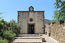
- 2 Church of Sant'Isidoro. Country church.
Sculptural monuments
Of considerable interest is the presence of dozens of marble and granite sculptures in all the squares and crossroads of the town and in the neighboring hamlets, the result of the International Meeting of Stone Sculpture that took place in the town from the 1980s to the early years of the new Millennium. These also include the bas-reliefs of the Via Crucis (in an anti-clockwise path through the streets around the Church of the Madonna del Carmine, in order: via XI febbraio, via Lamarmora, via Vittorio Emanuele, via Umberto I), as well as those dedicated to St. Francesco, outside the church of the same name.
Civil architectures
- 3 Baronial house, Parish Square.
Military architectures
- 4 Torre del Budello.
- 5 Tower of Sant'Isidoro.
Archaeological sites

- 6 Nuraghe Sa Perdaia.
Beaches
- 7 Capo Malfatano beach.
- 8 Tuerredda beach.
- 9 Perdalonga beach.
- 10 Porto Zafferano beach.
 Accessible only by sea and at certain times of the year as it is located inside the NATO military base.
 - 11 Porto Tramatzu beach.
- 12 Porto Pino beach (It is located inside the NATO base and is partly shared with Sant'Anna Arresi).
- 13 S'Ottixeddu beach (Americans Beach). Open to the public in the summer as it is located inside the NATO military base.
- 14 Campionna beach.
- 15 Piscinnì beach.
Events and parties

- Rites of Holy Week. In March or April. The various processions of Holy Thursday take place, the via crucis on Friday morning and Su scravamentu in the evening (or the deposition of Christ from the cross) and then conclude with S'incontru on Easter Sunday. This last event sees a double procession starting from two different points of the town, and then meeting in the center of the town (in via Cagliari, between piazza Fontana and piazza Mazzini), one (the one that starts from the Church of the BV del Carmelo) with the statue of the Madonna, the other (the one that starts from the parish of San Giovanni Battista) with the statue of the risen Christ. Once the two groups are reunited, the cunfradas that support the two statues perform ritual movements, and then make Christ lift the mourning veil of the Madonna. There follow the shots, the bells and the release of two doves; finally the procession gathers and goes up towards the Church of the Madonna del Carmine.
- Sant'Isidoro. In May and August. The procession starts from Teulada to reach the church of Sant'Isidoro, located in the locality of Tuerra, a fertile plain (in a context - the Teuladine - mainly hilly) in which the town was located before the seventeenth-century repopulation. In a second moment the statue of the saint is brought back to the village, transported by Sa tracca, an ox cart decorated for the festival. Since this is the most heartfelt holiday, the participation of numerous countries from all over Sardinia is natural, which with their different traditional costumes make the procession of August 21 an attraction also from a tourist point of view.
- Our Lady of Carmel. July 16. Patronal feast. The procession crosses Teulada in a long way, in which various folk groups also participate, albeit to a much lesser extent than in Sant'Isidoro.
What to do
- 1 Marina of Teulada (On Portu Nou), SP 71, km 2,175, Junction Teulada, ☎ 39 070 9283705, @[email protected]. Tourist port
Shopping
How to have fun
Where to eat
Moderate prices
- 1 Former power station, Martyrs Square 2, ☎ 39 070 7327972, 39 347 7625134 (Whatsapp). Food Coffee & Cocktails.
- 2 TanCa Bar, Via Sulcis 3, ☎ 39 327 5896613, 39345 6658833. Mon-Sun 6: 00-24: 00. Bar, sandwich shop, steakhouse and brewery.
- 3 Blue Moon, Piazza Mazzini 12, ☎ 39 342 0489988. Mon-Sun 7: 00-2: 00. Pizzeria bar.
- 4 Tomato and basil, Republic Square 12, ☎ 39 070 9270730, @[email protected]. Mon-Sun 18: 30-22: 00. Gastronomy pizzeria.
Average prices
- 5 Tirovino, Vico Martiri 2, ☎ 39 339 2625872, 39 393 9754957, @[email protected]. Wine shop.
- 6 From Stefano, Via Regina Elena 2 corner via Roma, ☎ 39 070 9270681, 39 349 8191608, @[email protected]. Restaurant.
- 7 The terrace, Via Cagliari 46, ☎ 39 070 4514199, 39 347 5218945. Bar restaurant-pizzeria.
- 8 The Blue Grotto, Piazza Fontana 1, ☎ 39 070 9270316. Trattoria.
- 9 La Pescheria fish farm, Via San Francesco 5, ☎ 39 347 1787154, @[email protected]. Seafood restaurant.
- 10 Rosa and Cadira, Via Sardegna 1, ☎ 39 334 2417561. Trattoria.
- 11 Sebera, Via San Francesco 8, ☎ 39 070 9270876, @[email protected]. Thu-Mar 12: 30-14: 00 and 19: 00-22: 00. Restaurant Pizzeria.
- 12 Half Moon, Via Sulcis 200, ☎ 39 070 9270440. Restaurant Pizzeria.
- 13 Trattoria da Gianni, Porto Budello location, ☎ 39 070 9283015, 39 349 3635204, @[email protected]. Tue-Sun 12: 45-15: 00 and 19: 45-22: 00. Seafood restaurant.
- 14 Sabor 'e Mari fish farm, SP 71, Porto Budello locality, ☎ 39 339 2254703, @[email protected]. Seafood restaurant.
- 15 White Hedgehog, SP 71, 11,600 km, Capo Malfatano locality, ☎ 39 344 0682469, @[email protected]. Bar restaurant.
- 16 Ittiturismo Antica Peschiera, SP 71, Capo Malfatano locality, ☎ 39 342 0733529, @[email protected]. Mon-Sun 12: 00-14: 30 and 20: 00-24: 00. Seafood restaurant.
- 17 Poseidon, Tuerredda locality, ☎ 39 339 7246817. Restaurant.
Where stay
Moderate prices
- 1 On Frascu Segau, locality Su Frascu Segau, ☎ 39 345 2415084, @[email protected]. B&B.
- 2 Tzia Licca, Via Brigata Sassari 33A, ☎ 39 331 7337026. B&B.
- 3 S'apposentu Teuladesu, Via Regina Elena 2 corner via Roma, ☎ 39 347 5820948, @[email protected]. Typical local style rooms.
- 4 S'Attobiu, ☎ 39 340 4966016, 39 340 2914812, @[email protected]. B&B.
- 5 S'Ollastu, Via Montegrappa 11, ☎ 39 070 9271059, 39 340 0551802, @[email protected]. B&B.
- 6 Cuccuddau house, Via Santa Lucia 16, ☎ 39 070 9273079, 39 347 8242025, @[email protected]. Check in: 14:00-20:00, check-out: By 10:00. B&B.
- 7 On Briglioni, Via Regina Margherita 1, ☎ 39 348 3428095, 39 333 6238950, @[email protected]. B&B.
- 8 About Tostainu, Via Canonico Murgia 18, ☎ 39 070 9270476, 39 347 7973425, @[email protected]. B&B.
- 9 Rio Launaxi Teulada, Via Tuveri 26 A, ☎ 39 070 9270229, 39 327 5896613, @[email protected]. B&B.
- 10 Tanca Is Torus, Via Tuveri 29, ☎ 39 349 3231639, @[email protected]. B&B.
- 11 Valparaiso, Via Enrico Addis 41, ☎ 39 070 9270446, 39 347 9810043, @[email protected]. B&B.
- 12 Tanca Marracconi, Via Alcide de Gasperi 55, ☎ 39 070 9270286, 39 346 9415513, @[email protected]. B&B.
- 13 Lemon yellow, SS 195 km 64,400, locality Su De Giuanni Efisi, ☎ 39 327 3636444, @[email protected]. Check in: 15:00-20:00, check-out: By 10:30. B&B.
- 14 Tegulahouses, SP 71, km 18,500, Campionna locality, ☎ 39 070 9270642, 39 348 3648167, @[email protected]. Holiday home.
Average prices
- 15 Locci residence, Vico II Sassari Brigade 15, ☎ 39 070 9272094, 39 349 2856283, @[email protected]. Check in: 15:00-19:00, check-out: By 10:00.
- 16 Jasmine Teulada, Via Francesco Ciusa 30, ☎ 39 333 9795358, @[email protected]. Hotel.
- 17 Sos Ventos Village, Location Arcu Dexiottu, ☎ 39 340 0852641, @[email protected]. Check in: 14:00-20:00, check-out: By 10:00 (hotel); by 11:00 (residence). Hotel residence.
- 18 S'Acqua Sassa, SS 195, km 65, Acqua Sassa locality, ☎ 39 331 9716861, 39 327 2855914, fax: 39 070 9283058, @[email protected]. Check in: 15:00-20:00, check-out: By 10:00. Resort hotel.
- 19 Portu Tramatzu, Portu Tramatzu locality, ☎ 39 070 9283027, 39 346 3988861 (winter phone), @[email protected]. Camping.
- 20 Bay of the Ginestre, SP 71, ☎ 39 070 0951996, @[email protected]. Check in: 12:00-17:00, check-out: 8:00-11:00. Hotel-residence.
Safety
Useful numbers
- 2 Carabinieri, Via Cagliari 53, ☎ 39 070 9270472.
- 3 Emergency medical Service, Via Guglielmo Marconi, ☎ 39 070 9270038, 39 070 9271081.
- 4 Tourist guard, Vico I Guglielmo Marconi 9, ☎ 39 070 9270087. July 1-August 31: Mon-Sun 8: 00-20: 00.
How to keep in touch
Post office
- 5 Post Office, Via Torino 26, ☎ 39 070 9270025, fax: 39 070 9270112. Mon-Fri 8: 20-13: 35; Sat 8: 20-12: 35.
Around

Other projects
 Wikipedia contains an entry concerning Teulada (Italy)
 Commons contains images or other files on Teulada (Italy)