| Thapsos | |
 | |
Location  | |
| State | Italy |
|---|---|
| Region | Syracuse |
| Territory | Syracusan |
| Surface | 1.5 km² |
| Institutional website | |
Thapsos is an archaeological site of the Sicily.
To know
It is one of the most important protohistoric sites in Sicily, even if not fully equipped for tourist use. It is in fact a site for archeology and history enthusiasts. In addition to the burial caves carved into the rock and traces of dwellings, ceramics have been found, some of which are of Mycenaean origin (and evidence of Mycenae) and some were locally produced.
Geographical notes
Thapsos is located in the Magnisi Peninsula, in the territory of Priolo Gargallo and a few kilometers from Syracuse.
When to go
The site can always be visited even if in the summer it is tiring due to the heat and the very few shaded spots.
Background

The center of Thapsos rises during the Bronze Age, that is between the 14th and 13th centuries. B.C. like a trading post from antiquity. From this place is characterized the so-called Culture of Thapsos what happens to the oldest Culture of Castelluccio. The trade was widespread in many areas of the Mediterranean including Mycenae from which it acquires various cultural elements found in the artefacts. These events obviously concern an era before the Greek colonization, which shows how the Sicilian area was widely known by the people of Greece. Probably the settlement following the Greek colonization of Syracuse from 734 BC. caused the abandonment of the site to reach further north (a Megara Hyblea) and from there, it is assumed that the population retreated into the mountainous hinterland (including Pantalica), there being similar shapes in the burial caves and in the pottery fragments.
After the Thapsos period, the peninsula loses its importance and the settlement is abandoned. The area becomes a strategic point in the course of the historical events of Syracuse up to the Second World War with the landing of the British who in this area will find some resistance due to the presence of bunkers and anti-aircraft batteries.
After the war, the peninsula was partially exploited by the industrialization of the area and a pier was built for the handling of petroleum products. Today the area is semi-abandoned and reduced to grazing by cows in the hope that the site will be revalued.
How to get
By plane
The nearest airports are:
- 1 Catania airport (Catania Fontanarossa Airport "Vincenzo Bellini". IATA: CTA), Via Fontanarossa, 20, Fontanarossa, ☎ 39 0957239111.
 00:00-24:00. Airport for national and international flights.

- 2 Comiso Airport (Pio La Torre Airport), ☎ 39 0932 961467, @[email protected]. Airport opened in 2007. Mainly operates seasonal and charter flights.
By car

The Magnisi peninsula can be reached from the ![]() /
/ ![]() Catania - Syracuse with exit for Priolo. From Priolo or even from Syracuse, the north exit from viale Scala Greca is used, you get to the former
Catania - Syracuse with exit for Priolo. From Priolo or even from Syracuse, the north exit from viale Scala Greca is used, you get to the former ![]() , where you turn towards Thapsos right in front of the ISAB south plant. From here you go along a promenade that leads to the parking lot (see below).
, where you turn towards Thapsos right in front of the ISAB south plant. From here you go along a promenade that leads to the parking lot (see below).
The Magnisi peninsula has rocky shores and no harbor suitable for private boats. The nearest port is that of Syracuse.
On the train
The nearest railway station is that of Priolo Gargallo on the Catania - Syracuse section. The station is about 4 km from the peninsula.
By bus
There are no public transport to reach the peninsula, except in the summer when shuttles are activated from Priolo Gargallo to the nearby beaches.
Permits / Rates
The built-up area is closed and cannot be visited unless a special request is made to:
- Superintendency of Syracuse, Piazza Duomo, 14 Syracuse, ☎ 39 09314508211, 39 0931450811, @[email protected].
The necropolis area and the peninsula are free to use.
How to get around

Inside the peninsula there are asphalted roads but a gate at the entrance prevents access by car. Therefore it is necessary to leave it in the 3 parking near the beach. For the rest it is necessary to continue on foot.
What see
Archaeological Area of Thapsos

The first excavations of the necropolis were carried out by Paolo Orsi at the end of the 19th century, which defined this Bronze Age culture as the Thapsos culture because of the ceramic finds. Around 1960-1980, excavations were again conducted under Giuseppe Voza and Luigi Bernabò Brea, with particular attention to the residential area near the isthmus, where the oldest buildings could be identified with the circular huts and later the rectangular buildings.


- 1 Inhabited of Thapsos (Archaeological area of Thapsos). It is possible to access the fenced area with the permission of the Superintendence of Cultural and Environmental Heritage of Syracuse. In the area of the settlement of Thapsos there is evidence of three types of residential huts. The huts of the first phase of Thapsos of the fifteenth / fourteenth century BC which have a circular plan, with some of the foundations still visible. The huts of the second phase of the 13th / 12th century BC they show a usually three-roomed rectangle-based structure around a central paved courtyard. In the third phase of the eleventh to the ninth century BC building structures are recognizable according to urban planning criteria, the ceramics found no longer come from the Aegean but are of regional production.
- The finds from Thapsos are exhibited at the Paolo Orsi Archaeological Museum in Syracuse.
- 2 Necropolis of Thapsos. Free use. The necropolis are divided into three areas, the Northern Necropolis, the Central Necropolis and the Southern Necropolis. In addition to the well tombs, there are also the so-called tombs a tholos, domed tombs with passage-like access (dromos), reminiscent of the tholos tombs of Mycenae. Inside there are usually several niches distributed around the round interior. They are easily recognizable because they are close to the coast (at least the northern ones).
- In the central area of the peninsula the burials were ad enchytrismòs where the buried were placed without equipment in ovoid containers (pithoi) and placed in natural cavities of the rock.
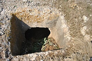
Pit tomb

An internal rotunda with niches

Square huts


- 3 Fortifications. In this area there were fortifications that ran from north to south so that the remains of six semicircular towers are visible.
Other

- 4 Magnisi Tower. This lonely circular tower was built in 1806 by the British during their protectorate on the island for fear of a French attack. The tower is accessible from one side, you can even reach the roof even if you have to climb to the upper floor by climbing through makeshift holds. From the roof you can enjoy a beautiful view of the promontory.

- 5 World War II bunker (Next to the farm and the necropolis). Free access. The strategic position of the promontory has favored the creation of a series of World War II bunkers for the defense of the coast. Several circular anti-aircraft artillery positions are still visible, many of them are connected to tunnels that lead to bunkers and hiding places.
- 6 Disused factory (At the entrance to the isthmus). This abandoned factory for years is reminiscent of the industrial past of the peninsula and the intensive exploitation of the territory following the petrochemical production model. Unfortunately, the ruined buildings remain there as an ugliness that degrades the area.
- 7 Magnisi wharf. This pier in the south-east of the island was built at a time when environmental and archaeological sensitivity was rather poor. Today, albeit greatly reduced in its use, the pier reminds us of a declining development model.
- 8 Lighthouse. Coastal signaling lighthouse.
What to do
Next to the car park, there is a bathing beach. Even in other parts of the promontory, especially those to the east it is possible take a bath, but they are less easily accessible.
The whole promomtorio is suitable for taking a mountain bike ride along the dirt paths.
Shopping
There is no commercial activity in the area, except contact the nearby Priolo or go to the Auchain shopping center.
Where to eat
In summer, the presence of the beaches allows you to find bars or restaurants. Normally it is better to go to Priolo, Syracuse or to the Auchain.
Where stay
The best place to stay is Syracuse, where the offer of accommodation is wide.
Safety

On hot summer days, you need to have a hat and sunscreen with you. Furthermore, it is necessary to have an adequate quantity of drinking water because there are no trees or shaded spots on the entire promontory.
At the entrance to the peninsula, heaps of 4 pyrite powder as industrial waste. Although these mounds are covered, they are damaged by wind and atmospheric agents and dust can spread around. It is not recommended to get close to the dust and to stay too long especially if there is a north wind.
Inside the peninsula there are free grazing cows.
How to keep in touch
Telephony
The telephone signal is present throughout the peninsula.
Around
If you are interested in archaeological sites, we recommend that you visit the archaeological museum in the nearby Syracuse, but also the necropolis of Pantalica and possibly also the Greek excavations of Syracuse and Megara Hyblea close to Augusta.