
| Pantalica | |
 | |
Location  | |
| State | Italy |
|---|---|
| Region | Sicily |
| Territory | Syracusan |
| Institutional website | |
Pantalica (or Rock Necropolis of Pantalica) is a protected area and an archaeological site UNESCO of the Sicily.
To know
The archaeological site of Pantalica is part of the Pantalica oriented nature reserve, Anapo Valley and Cava Grande stream.
It is one of the most important Sicilian proto-historic sites, useful for understanding the moment of transition from the Bronze Age to the Iron Age on the island.
Geographical notes
The Pantalica site extends over a vast and varied area between the municipalities of Ferla, Cassaro is Sortino. It includes the valleys on which the Anapo river and the Calcinara flow and the summit areas on which the plateau develops are covered with vegetation on which stands the Wood of Giarranauti. The connection between Giarranauti and the Pantalica plateau, where the Anaktoron palace stands, is a narrow strip of land crossed today by the Regional Road 11 which from Ferla goes to the end of the road known as the Saddle of Filiporto.
| The stones of Pantalica | |
 The beauties and nature of Pantalica were told by the writer Vincenzo Consolo in his poetic novel The stones of Pantalica of which an extract is reported:
|
When to go
| Climate | gen | Feb | mar | apr | mag | down | Jul | needle | set | Oct | nov | dec |
|---|---|---|---|---|---|---|---|---|---|---|---|---|
| Maximum (° C) | 12,5 | 13,1 | 14,5 | 16,8 | 21,2 | 25,7 | 28,7 | 28,9 | 26,1 | 21,4 | 17,4 | 13,9 |
| Minimum (° C) | 5,5 | 5,3 | 6,3 | 8,4 | 12,1 | 16 | 18,6 | 19,2 | 17,1 | 13,5 | 9,8 | 6,9 |
| Precipitation (mm) | 72 | 40 | 50 | 30 | 17 | 9 | 4 | 14 | 34 | 104 | 65 | 68 |
Climatic averages recorded a Sortino taken from climate-data.org | ||||||||||||
Pantalica can be visited at any time of the year even if with some limitations. In winter the valley can be very humid and cold, moreover the rains make the ground slippery. In summer, temperatures can be excessive for hiking, unless you consider a ride in the valleys sufficiently sheltered by trees. Therefore it is simply necessary to consider the possibility of performing different activities based on the season and climatic conditions.
Background

.jpg/220px-Pantalica_gorge_(356575873).jpg)
The site of Pantalica was inhabited starting from the 13th century BC. when the populations who lived on the coast, in Ortigia, Thapsos and other places took refuge in these inaccessible but perfect places to be defended from enemy attacks, to possess an abundance of water and food. This shift creates a cultural specificity in ceramic artifacts but above all in the construction of rock tombs, for which the site is famous.
Around 1000 BC a temporary shift takes place towards the coast and then returns to being a central site in 850 BC. until the arrival of the Greeks on the coasts which determines clashes but also a growing influence due to commercial contacts. This will also favor the birth of Megara Hyblaea thanks to an agreement with king Hyblon who was probably at the head of the peoples of Pantalica. However, the subsequent Greek rule extinguished the population in Pantalica for many centuries until the 6th century AD. when it becomes a place of refuge for the Byzantine population of Syracuse and its surroundings. In this era the first barbarian incursions and then the Arabs determine the birth of those communities that will create the Byzantine villages of San Micidario, San Nicolicchio and nuclei a Giarranauti. The communities in Pantalica will survive the Arab and Norman conquests and then lose their importance and completely depopulate in the following centuries.
Since then Pantalica has remained an abandoned site and for this reason intact from a naturalistic and landscape point of view. In the early twentieth century the archaeologist Paolo Orsi will carry out a series of excavation campaigns, finding many finds and providing a first reconstruction of the history of these places that will be further investigated by Bernabò Brea in the 1950s.
There Pantalica oriented nature reserve, Anapo Valley and Cava Grande stream it was established in 1997 and in 2005 the recognition also came UNESCO as a heritage of humanity.
How to get
By plane
The airports of eastern Sicily are:
 Catania airport (Catania Fontanarossa Airport "Vincenzo Bellini". IATA: CTA), Via Fontanarossa, 20, Fontanarossa (By bus to Sortino or Ferla), ☎ 39 0957239111.
  00:00-24:00. With national flights to all Italian cities and several European international locations.

- Comiso Airport (Pio La Torre Airport) (Direct bus connections only from Catania), ☎ 39 0932 961467, @[email protected]. Airport inaugurated in 2007. It mainly carries out seasonal and charter flights with destinations to some Italian and European cities.
By car
The most used vehicle is undoubtedly the car. It allows you to move easily between the various parts of the reserve and to reach it without problems.
- From Sortino
- taking via Pantalica or la
 reaching theSortino entrance;
  then on the right following the signs for the Anapo Valley.
- From Solarino
 then continue on shortly after turning left following the signs for the Anapo Valley.
By bus
Except for special tourist services organized by tour operators, there is no public service that allows you to reach Pantalica, unless you do not reach it Ferla or Sortino and then find the way to go to Pantalica.
Permits / Rates
Admission to the reserve is free and without authorizations. However, the Anapo Valley route is likely to be closed for 3 days due to heavy rains, for safety reasons.
To access the route of the former railway by bicycle, a written authorization from the managing body is required. For entry, some requirements are necessary: bicycles must be fitted with front and rear lights even during the day, due to the transit in the tunnels. The request must indicate the name of a manager as well as the list of all participants with date of birth. Authorization can be requested at the Syracuse office or online via email. You will be sent a form in which to indicate all the members of the group. the authorization is issued for the opening hours of the site and the same can be sent online.
 1 Service Office for the Territory of Syracuse ex UPA, Via S. Giovanni alle Catacombe, 7 Syracuse, ☎ 39 0931 67450, fax: 39 0931 62373, @[email protected]. Office responsible for the management of Pantalica and forest and natural areas of the Province of Syracuse.
On site, in addition to the manned entrances where you can ask for information, there is a special office:
- 2 Information office of Pantalica (From about 5 km from Ferla). Mon-Sun 9: 00-19: 30. Office capable of providing all the necessary information on Pantalica. Brochures are also available, although they finish soon.
How to get around
Within the reserve you move mainly on foot, or in areas suitable for cycling. However, as the area is very large, there are several entrances and various access possibilities that can be reached by car.
Manned entrances
There are three manned entrances in the daily time slots until sunset. Outside these hours the gates will be closed, however it will be possible to exit through the minor side entrances. The presence of bicycles could be a problem:
- 3 Entrance to the Anapo Valley (Take the near Sacre Pietre restaurant). From morning to sunset. Entrance for access to the valley and the Anapo River, as well as for authorized bicycles.
- 4 Sortino entrance, via Pantalica, Sortino (From Sortino take via Pantalica until the end of the road). From morning to sunset. Entrance from Sortino to the Calcinara stream.
- 5 Cassaro-Ferla entrance,
 (Immediately after the bridge over the Anapo). From morning to sunset. Entrance to the Valley, prohibited to bikes.
Unattended entrances

- 6 Calcinara entrance on the Ferla side, (At the end of the Regional Road 11 from Ferla). Entrance from Ferla for the Calcinara stream and other directions.
- 7 Path Necropolis of Cavetta, .
- 8 Wood of Giarranauti entrance, . Woodland entrance with paths suitable for cycle and pedestrian paths.
Parking lots
The car parks are located in correspondence with the main paths. They are free and indicated in the maps of the reserve:
- 9 Parking information center, . The car park is large enough to accommodate campers and small buses, however it is only open during the opening hours of the information center.
- 10 Parking of the Sella di Filiporto, . From this parking lot it is possible to follow the path of the Necropolis of Filiporto and that for San Micidario.
- 11 Parking of the Anaktoron, . It is an unpaved space near the Anaktoron, suitable for visits starting from this point.
- 12 Calcinara parking, at the end of the . It is located at the end of the road, it can hold a few cars, and is useful for those who go down the Calcinara path.
- 13 Cassaro side entrance parking, (At the crossroads between Cassaro and Ferla). In front of the entrance to Cassaro.
There are other "car parks" at the entrance from Sortino and the Anapo Valley, but they are not really dedicated spaces for cars.
By bike
Some parts of Pantalica are suitable for bicycle use. The Giarranauti wood is planned as a series of pedestrian and mountain bike paths. The same ![]() it is entirely passable due to the low traffic.
it is entirely passable due to the low traffic.
The second cycling route is that of the former railway line in the Anapo valley. It is accessed from the entrance to the Anapo valley and a written permit is required (see section above).
What see
Ferla side
Starting from the center of Ferla, take the ![]() , from here the following points can be reached:
, from here the following points can be reached:

- 1 Necropolis of San Martino (Take from Ferla
 Map of the Necropolis of San Martino, one kilometer from the town, on the left find the indication with an uphill path. Unfortunately there is no parking, so you will have to leave your car on the side of the road). It is a necropolis composed of prehistoric tholos tombs and Byzantine catacombs called: Hypogeum of Dionysius is Cave of Sant'Anna. The first dates back to the 4th - 5th century AD. and at the entrance there is an inscription that reads: "Dionisio who served as a presbyter in the Erghitan Church for 34 years sleeps here in eternal sleep." While in the second it probably dates back to the 11th-13th century, it has frescoes on some walls in which the figures of saints are partially recognized: St. Mary and St. Peter as well as St. Anastasia. In both necropolis there are monumental canopied tombs. The path is not very easy and to find the tombs you have to follow the indications that are not always very precise.


Saddle of Filiporto
Reached the Parking of the Sella di Filiporto it is possible to follow two paths, the shortest is that of Filiporto Necropolis. The path of San Micidario, longer, includes a walk of at least an hour where you reach L 'Oratory and the village of San Micidario, the village of San Nicolicchio and if you want you can go up to theAnaktoron or go down to the Anapo Valley with a difference in height of about 300 m.

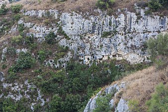
- 2 Filiporto Necropolis (From the car park, follow the path indicated by the signs). It is a necropolis made up of a thousand tombs that extend on the slopes and in the Anapo basin on the south-west side. The cave tombs belong to the last phase of the city that is to the IX-VIII century BC.

- 3 Defensive moat (Next to the parking lot of the Filiporto necropolis). Shortly after the "saddle of Filiporto", a narrow strip of land that joins the plateau of Pantalica, there is the Pantalica gate, which is now partially visible through an entrance and traces of an ancient moat. All around the archaeologists have also found the signs of fortifications from the Byzantine era, a sign that the area was also fortified in the epochs following the pre-Greek ones. Along the door continue towards the village of San Micidario.

 4 Oratory and necropolis of San Micidario (From the Sella di Filiporto car park, take the San Micidario path, with a walk of about 20 minutes). It is a Byzantine village of about 150 houses overlooking the valley. Not far away there is also the little church of S. Micidario on the edge of a chasm. Faint traces of frescoes and inscriptions in poor condition are still visible inside the oratory. However, we recognize the figure of the Pantocrator flanked by two angels and another figure, perhaps a Saint Mercury due to an inscription in Greek which should confirm the identity. The ceiling has an interesting double sloping shape. From the oratory you enter on the right a second room with tombs on the floor while the second room could have been used as a prison or shelter for animals because it has stone rings where it was possible to tie something. The lower hole facing the cliff might be an ancient toilet.San Micidario
 - the church of San Micidario


- 5 San Nicolicchio village (Continuing along the path of San Micidario, or coming from Anaktoron). Located at the foot of the Anaktoron, the small village of San Nicolicchio takes its name from the oratory decorated with traces of fresco, unfortunately quite ruined. However, the figures of Sant'Elena and Santo Stefano are recognizable. The dating seems to be from the 7th century.

- 6 Prince's Palace (Anaktoron) (Take from Ferla and turn to the indications).
 The Anaktoron building is still a kind of mystery to this day. It is a stone construction dating back to the 12th-11th century BC. where there are no similar works other than rock-cut tombs or simple huts. It has therefore been hypothesized that it was the palace of the local prince or even the coffer whose construction attracted Mycenaean workers, as they have been known to have traded with Sicily since ancient times. In the Byzantine era it was reused by making changes, but in later times it was abandoned.
 - 7 Northwest Necropolis (The necropolis is visible along the or from the Calcinara valley but there are no safe paths to reach it). One of the oldest necropolis in the area (XII-XI century BC).

- 8 North Necropolis. The largest and densest necropolis of Pantalica, dating back to the 12th-11th century BC. it is clearly visible from the belvedere at the end of the or by accessing from the entrance on the Sortino side.
- 9 Cavetta necropolis (Going through the take the path on the right). Necropolis of the IX-VIII century BC with the presence of Byzantine houses. The path where the necropolis of Cavetta is indicated actually leads to a panoramic point where it is possible to partially see the confluence of the Anapo with the Calcinara. The necropolis is partially visible in front, beyond the street level. Some cave dwellings can also be reached from the path in the curve of the . The remaining tombs of the Cavetta are visible from the path of the Cave found.
Entrance of the Church of the Crucifix

Cavetta necropolis from the Cavetta path
tombs of Cavetta from the path of the Grotta Trovata


- 10 Church of the Crucifix (At the end of the from Ferla go down the Calcinara path). This small rock environment was used as a Byzantine church. Inside it is recognizable a rectangular apse with the remains of a crucifixion fresco as well as the representation of St. Nicholas and an anonymous saint. Continuing along the path you go down to the Calcinara stream and it is possible to rejoin the path on the Sortino side as well as go to the Cave of the bats.
- 11 Cave found (Once you have taken the path to the Church of the crucifix and the Calcinara, turn immediately right). The narrow path leads to the Grotto found a karst cave with a narrow entrance for which it is necessary to crawl. To enter it is obviously useful to be equipped and experienced. Along the way, opposite, the tombs of the Cavetta necropolis.
Giarranauti


Access the area of the Bosco di Giarranauti:
- 12 Byzantine tanneries, Wood of Giarranauti (Follow the path indicated by the main path). Although only traces remain on the ground, tubs and buschi for tools, the ancient tanneries used by the inhabitants of Pantalica in the Byzantine era are visible.
- 13 Byzantine settlement of Giarranauti (From the main path, turn north-west). Along the path to the north-west is a Byzantine village where the foundations of a church and some stone houses are visible.
- 14 Ancient oil mill. Traces on the rock of an ancient Byzantine oil mill.
- 15 Ancient sheepfold (At the forestry building). Ancient stone sheepfold with fence.
- 16 Giarranauti houses. Ancient farm with fences for livestock today used by the forest.
Sortino side

After the entrance on the Sortino side, in addition to the Calcinara river it is possible to visit:
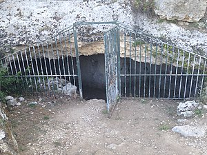
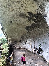
- 17 Cave of the bats (From the entrance of Sortino go down to the river then continue east for 50 meters). It is a natural cave that flanks the Calcinara river. Immediately after the large entrance, after a 12 m corridor, there is an internal room full of bats. Enter only if you are equipped with torches and suitable clothing. Also watch out for bats.
Anapo Valley

The Anapo Valley is the lowest point of Pantalica accessible from the two entrances from Ferla or from the Anapo Valley:
- 18 Former station of Pantalica (along the route of the former railway). This old building along the railway line was the Pantalica station from which the steam trains that reached Vizzini passed. Today its rooms house a small museum of peasant life objects.
- Unlit galleries (Former railway line). Along the former railway line you will find the old unlit train tunnels, a building engineering work of the last century.
- 19 Point of confluence between the Calcinara and the Anapo (Immediately after the second tunnel take the path on the right.). At this point the confluence of the Calcinara stream and the Anapo river takes place, a spectacular point located within the valleys carved into the living rock. Along the north wall also runs the route of the Galermi aqueduct which has its intake point nearby.
- 20 Rocky environments mirrors (At the crossroads with the mirror houses, take the path that goes up beyond the tunnel. The path is not indicated.). These rooms still lacking a systematic study, were probably used as an ancient millstone whose time is unknown. The lower room was a stable, while on the upper level there were basins probably for crushing the grapes. Finally, in the higher room there were the lodgings with openings that look towards the mirror houses and the valley.
Stable

Palmento

View over the valley

The rooms from the main road

Access steps to the path


- 21 Mirror houses (Along the dirt road about halfway between the two exits). These buildings today used by the forestry are a fine example of an old Iblean millstone with a patio and the living and working environments around it.

- 22 Cave of the Star (About 1 km from the Cassaro side entrance on the top right.). This cave can only be observed from a distance by looking along the south walls of the Anapo Valley. The almost vertical slope makes it impossible to access, unless you are equipped with climbing equipment. In 2012, some researchers identified traces of anthropization that suggest its function as a prehistoric temple with a dome measuring 50m wide and 25m high.

- 23 Villa of the roses. A villa owned by the park that has been restored but still not intended for use. It is located near the river and can be visited outside.
_03.jpg/150px-Anapo_vicino_l'ingresso_di_Pantalica_(Valle_dell'Anapo)_03.jpg)
- 24 Dam on the Anapo River. Dam in use for the canalization and exploitation of the waters of the Anapo river. The dam is not accessible.
- 25 Access to the Anapo River (Immediately after the entrance gate on the left, go down the steps). From this point, only recently opened, you can access the Anapo river and you can admire some canals that conveyed the waters of the river, the locks and the first railway bridge from below.
What to do

Pantalica allows you to do different activities. The most popular modality is that of hiking among the many paths or that of picnicking at the equipped areas.
1 Equipped area easily reachable from the Cassaro-Ferla entrance. There are picnic benches and tables. The area is also ideal for the presence of the river and a lot of shade.

- 2 Hike along the SR-1 trail. The trail connects Tolls to Cassaro passing through Ferla. From Pedagaggi take the
 towards Buccheri, then continue to the SR 5 Ferla-Pedagaggi on asphalt, then turn right onto the path marked by a sign. He continues west of Monte S. Venera until he reaches the
  which will be crossed, you go on a dirt road on the municipal road Piano Santa Croce. From here you get to the
  and continue up to the inhabited area of Ferla. You cross the country to the south, always following the towards Cassaro. Then you reach a natural staircase on the right that left the it will then resume it along the crossroads between Cassaro and Ferla. From the crossroads, follow the signs and continue until you reach the provincial road that leads to the town of Cassaro. You exit south in the direction of the Anapo Valley continuing in the last stretch that intersects several times the
  and reaches the bridge over the Anapo near the entrance to Pantalica.
- To view the route check "hiking routes" in the dynamic map.
- The hiking trails of Pantalica are indicated in detail in Hyblaean paths.
Bicycle

For bicycle enthusiasts, a walk along the former railway line of the Anapo Valley is very pleasant, even if an authorization is required (see above).

Go mountain biking at the wood of Giarranauti (to bear in mind that the cycling route is quite tiring, unless you are already trained). Some sections may not be well traced, in this case we recommend the use of GPS. There are two viewpoints inside the forest that are worth reaching:
- 14 panorama of Syracuse at the end of the path, at the highest point it is possible to see Syracuse and the port.
- 15 panorama of Sortino along the circular route, a clearing on the Calcinara river from where you can see a beautiful view of Sortino.
Although officially prohibited by the reserve's regulations, many tourists and locals go from the Anapo Valley entrance or the Sortino entrance to bathe in the river during the summer season.
Organized tours
There are not many agencies specializing in guides on Pantalica. In many cases the same ones that organize tours in other parts of the Syracusan I can arrange a minibus and a guide. However, the following should be noted:
- Hermes Sicily, ☎ 39 346 5787561, @[email protected]. Syracuse tourist agency, also offers tour packages for other destinations in the province of Syracuse and Ragusa.
- Discover pantalica. Tourist guide for Pantalica.
- Pantalica Experience, Sortino - Ferla, ☎ 39 3384752390, @[email protected]. Excursions to Pantalica and the Anapo Valley. Trekking, archeology and nature.
Panoramic points
The orographic conformation of Pantalica allows for many panoramic points. Below we indicate the most popular ones:
- 16 Filiporto parking panorama on the Anapo valley from saddle of Filiporto.
- 17 San Micidario at the village of San Micidario.
- 18 Cavetta viewpoint at the end of the Cavetta path, the Anapo is visible.
Shopping
For purchases, as there is no commercial activity, it is necessary to go to Sortino or Ferla, or go to Syracuse to have more choice.
Where to eat
- 1 Villa Pantalica, (After the information center), ☎ 39 3358273590.
Almost all the farmhouses listed below are also restaurants. Considering the few structures present, one can turn to neighboring countries: Sortino is Ferla.
Where stay

- 1 [link not working]The garden of Pantalica (Farmhouse) (Anapo Nature Reserve Cassaro side entrance), ☎ 39 329 24 17 636, 39 0931 17 91 080, @[email protected].
 50 - 75 €. Farmhouse with swimming pool inside the Reserve. Entry by car is authorized at the Cassaro side entrance of Pantalica.
 - 2 Agriturismo Porta Pantalica, c. from Mascà, ☎ 39 0931 1791058, 39 331 3864354, @[email protected].
- 3 Sacred Stones, Anapo Valley, ☎ 39 0931 959849, 39 340 5319645, @[email protected]. Farmhouse and restaurant, bike rental.
- 4 Pantalica Ranch, Board of Directors Chianazzo Fiumara di Sotto - Sortino 96010 (SR), ☎ 39 348 5327687, 39 0931 954425, @[email protected]. 40 - 78 €. Check in: 12:30-18:00, check-out: 08:30-10:30. Farmhouse and restaurant
- 5 Campanìo farmhouse, ☎ 39 339 7314089, 39 393 9143592, ☎ 39 0931 1846080, @[email protected].
Safety

Pantalica is a quiet place, however there are several risks for hikers and visitors. In certain seasons there is always the risk of being bitten by vipers, even if it is a rather rare event. Furthermore, the presence of significant differences in height constitutes a serious danger of falling. For this reason it is always important keep to the official paths dressing appropriately with trekking shoes and long dresses.
During the summer, excursions can be very tiring because the temperatures are excessive and the sun is too strong. It is therefore recommended to avoid the hottest time slots, except to stop in the shaded areas of the Anapo Valley.
In winter period in case of torrential rains the area can become dangerous due to landslides or rock falls from the highest points. Furthermore, the presence of mud does not make it easy to walk on slopes, with the risk of falling.
If you were to choose to travel the former railway track, remember that the galleries are not illuminated and some, being long, cause conditions of total absence of light. The use of flashlights or at least cell phone lighting is therefore recommended.
As the reserve is very large, there is a risk of reaching areas that are not very popular with hikers. In case of illness or accident it is always good have a cell phone with a battery reserve for any emergencies.
There are several unprotected paths where you can risk falling. Also pay attention to vipers whose encounter is rare but not impossible.
How to keep in touch

Telephony
In many areas of Pantalica there is the possibility that cell phones will not be picked up, especially in the Anapo Valley.
Internet
Except within accommodation facilities or via the cellular network there is no internet connection via Wi-Fi.
Around
| Nearby | ||
| Tolls 30 km | Sortino 30 km | Melilli 42 km |
| Ferla 10 km |  | Priolo Gargallo 48 km |
| Palazzolo Acreide 32 km | Canicattini Bagni 35 km | Solarino 34 km |
The area of Pantalica is rather isolated but several Hyblean villages can be reached nearby such as:
- Sortino - Famous for its fine Baroque architecture but above all for being the "homeland" of pizzolo.
- Ferla - Pretty town, defined as the "gateway to Pantalica" due to its proximity to the area.
- Palazzolo Acreide - From the elegant Baroque architecture to the small Greek theater, it is definitely worth a visit.
- Buccheri
Or you can return to the coast to go to:
- Syracuse - Tourist city, rich in monuments from the Greek and Roman times with the splendid Ortigia island.
- Known - Defined as the "stone garden" for its monumental Baroque architecture.
- Thapsos - Peninsula rich in important prehistoric remains and bunkers from the Second World War.
- 19 Bosco Demanio Santa Venere (entrance along the ). Wooded area great for shady walks and picnics.