Hyblaean paths - Sentieri Iblei
Hyblaean paths are a series of hiking trails that develop through the Iblei Mountains of the Syracusan.
Introduction
Geographical notes
The affected area is that of the Iblei Mountains located in the Syracusan territory, with the presence of several caves (canyons dug by the erosive action of water) and the Pantalica oriented nature reserve, Anapo Valley and Cava Grande stream.
When to go
These paths are practicable almost at any time of the year with the exception of summer when the temperatures are excessive.
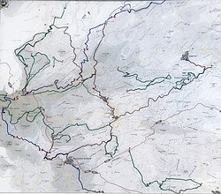
Trails
|  |
| Length: 12 km |  200 m 200 m |  4 hours 4 hours |  experts experts |
|
 View of Francofonte along the ascent route near Pedagaggi  Buccheri-Sortino. Cross the road taking a small road with a natural bottom which you follow up to a first junction, not very evident, where you have to turn right until you reach a second junction at the beginning of a small depression. From this point the itinerary divides. Keeping to the left, follow the path 908 which allows you to reach the village of Ferla crossing the San Giovanni valley (necropolis) and then arrive at the Buccheri-Sortino. Cross the road taking a small road with a natural bottom which you follow up to a first junction, not very evident, where you have to turn right until you reach a second junction at the beginning of a small depression. From this point the itinerary divides. Keeping to the left, follow the path 908 which allows you to reach the village of Ferla crossing the San Giovanni valley (necropolis) and then arrive at the  just before the Ferla cemetery. just before the Ferla cemetery. |
From the former Cassaro station a Ferla | |
| Length: 8 km | 1000 m | 3 hours | tourist |
|
From the former station of Cassaro on the Anapo Valley You reach Cassaro Following the  . You leave Cassaro along the via Regina Margherita, which you leave after about 600 m near a guardrail. You then follow the ancient link between Cassaro and Ferla, crossing the paved road three times. Near a small house with a large tree, take the asphalt up to the bridge between three roads (signposted Ferla). Immediately after the bridge on the right, a dirt road leads to a narrow asphalted road that climbs to the left. You cross the provincial road and, opposite, you will find the ancient communication route that led to Ferla. . You leave Cassaro along the via Regina Margherita, which you leave after about 600 m near a guardrail. You then follow the ancient link between Cassaro and Ferla, crossing the paved road three times. Near a small house with a large tree, take the asphalt up to the bridge between three roads (signposted Ferla). Immediately after the bridge on the right, a dirt road leads to a narrow asphalted road that climbs to the left. You cross the provincial road and, opposite, you will find the ancient communication route that led to Ferla. |
| |
| Length: 62 km | 1000 m | 20.5 hours | Expert hikers |
|
Description: You leave Palazzolo along the ancient path that descends from the former railway station of the line Syracuse-Vizzini. From the former station, follow the railway path westwards to the next former station ( Buscemi). From here, an abandoned asphalted road branches off to the right and must be followed up to a crossroads on the left under a large overpass. Turning right at the crossroads you begin to walk along a white-ground road that runs along the river. From here, following some traces of paths, you reach the enclosure of the forest property. You enter the state property and continue, always along the river until you meet a white road and reach a crossroads. Turn left and continue, following the river, up to the farmhouse located at the end of the valley. From the farm you go up along a path that climbs the ridge that overlooks it, and you reach an asphalted road that you have to follow up to under an overpass. From here you have to enter a forest gate and take a white cart track that passes next to the altar of San Giovanni Gualberto. After the altar, on the right, a path begins which you follow up to a crossroads located under a forest stop area. Then turn right and, halfway uphill, you will reach the intersection of an asphalted road. Cross the hillside and pass some pastures and enter a wood. At the exit of the wood there is a small church and from the small road you reach the town. |
 From: Buccheri (811 m a.s.l.) From: Buccheri (811 m a.s.l.) | | 7 hours |  TO: Tolls (335 m a.s.l.) TO: Tolls (335 m a.s.l.) | | 500 m |
Description: You leave Buccheri following the provincial road for Catania up to the first bend, where you turn right along a path halfway up. You reach a small valley which you have to climb up to an asphalted road. Turn left and, after passing a fountain, take an easy path that continues halfway up the hill. Continue along the level curve, by tracks, and after having passed a truly unpleasant passage, among shrubs and stones, you arrive at a road. Take it and then reach a crossroads, turn left and, after a descent, you will reach a forest shelter. From here you follow a road which, first downhill until you reach a crossroads (turn right), then halfway up, reaches a drinker. Shortly after, the road begins to climb, continue until the first bend from where you exit the forest property. You go along the fence downhill and go back to some olive trees. From here you reach an evident and very panoramic hillock. From the top of the knoll, to the right and along tracks, you reach the bottom of a small valley. You cross, turning left, you pass next to an ancient rock settlement reaching, therefore, a masseria, from where a downhill road starts. Follow it up to the first bend, then turning right towards another masseria which you reach after passing a tree-lined valley. From here you go up to the high exit of the fenced land, continuing in the direction of other abandoned farms. Finally, following an obvious path that points towards the valley floor, you reach the provincial road. Turn right and after a kilometer you will reach Pedagaggi. |
| From: Tolls (340 m a.s.l.) | | 6.30 hours | | TO: Carlentini (220 m a.s.l.) | | 200 m |
Description: From Pedagaggi You reach the cemetery and along a cart track, a valley. Go down, passed a ford, go up on the other side and turn right, near a hut. You then go up on a cart track and continue, then, halfway up the hill reaching a valley (complex of abandoned buildings). Go up the valley and, after a wide curve to the left, you will reach a forest road. Turn right and reach a signposted point where you go down to the left in the forest reforestation area. Head towards the huts of an aqueduct and from the last one you reach the valley floor near a farm. From here, head to the right on a small road up to a bar where you turn left, quickly reaching an asphalted road. From here (deviation to the right: Borgo A. Rizzo) turn left following the asphalt up to a small bridge, where you turn right. Head towards an obvious communication tower, shortly before which you turn left towards the building of an agritourism business from where you reach Carlentini. |
Paths of Giarranauti | |
| Length: 15 km | 200 m | 4 hours | hikers |
|
You get out of Ferla along the  for Pantalica, which you follow up to km 3. From here, turning left, you reach the entrance to the forest property. The Giarranauti path winds for the first 2 km through a vegetation characterized by a beautiful holm oak which then thins out to gradually make way for the Aleppo pine. Other paths branch off from the Giarranauti path: at 1.6 km, we find the eucalyptus path (1 km) rich in eucalyptus, holm oaks, cypresses; at 1.65 km after the fire-fighting tank, on the right we have the Sperone path (2.3 km) which winds along the valley floor. The vegetation is characterized by a dense oak forest. At km 0.75 of the Sperone path, on the right, there is a steep path that goes into a pine forest for 1.45 km, ending with a gate that separates the wood from the . At km 2.5, you will find the beginning of the path to the Ferla wood. At km 5.2 of the path of the Ferla wood there is a crossroads: the path on the right enters the thick vegetation to end, after about 900 m, at a gate; continuing on the left, on the main path, after another 2 km, you reach a gate beyond which you will find the municipal forest of Ferla, rich in holm oaks and downy oaks. The path that crosses the Ferla wood ends, after 450 m, at a gate on the edge of the . Continuing on the Giarranauti path instead, you reach Giarranauti houses. From here the path, after having crossed a eucalyptus wood, leads to a panoramic area on the Calcinara quarry. At km 1.2 the path forks near the ruins of an old rural building called Case Comuni: along the left path, which follows the edge of the plateau, you reach (at km 2.5) another viewpoint on the quarry, at the point of the confluence between the Sperone and Calcinara torrents; continuing, the path leads back, after about 650 m, to the Giarranauti houses. On the other hand, following the path on the right, you go up to the top of the plateau along a dirt road which, after about 750 m, leads back to the Giarranauti houses. Along the Giarranauti path there are testimonies of man's work in these places: at km 0.8 a limestone (kiln built in dry stone for the production of lime), at km 1.6 Mandre Mare, an old post office, at km 1.8 a factory for the tanning of skins from the Byzantine era; at km 2.5 the Byzantine village of Giarranauti, and at km 4 Giarranauti houses, an old rural building now owned by the regional state-owned forest company. for Pantalica, which you follow up to km 3. From here, turning left, you reach the entrance to the forest property. The Giarranauti path winds for the first 2 km through a vegetation characterized by a beautiful holm oak which then thins out to gradually make way for the Aleppo pine. Other paths branch off from the Giarranauti path: at 1.6 km, we find the eucalyptus path (1 km) rich in eucalyptus, holm oaks, cypresses; at 1.65 km after the fire-fighting tank, on the right we have the Sperone path (2.3 km) which winds along the valley floor. The vegetation is characterized by a dense oak forest. At km 0.75 of the Sperone path, on the right, there is a steep path that goes into a pine forest for 1.45 km, ending with a gate that separates the wood from the . At km 2.5, you will find the beginning of the path to the Ferla wood. At km 5.2 of the path of the Ferla wood there is a crossroads: the path on the right enters the thick vegetation to end, after about 900 m, at a gate; continuing on the left, on the main path, after another 2 km, you reach a gate beyond which you will find the municipal forest of Ferla, rich in holm oaks and downy oaks. The path that crosses the Ferla wood ends, after 450 m, at a gate on the edge of the . Continuing on the Giarranauti path instead, you reach Giarranauti houses. From here the path, after having crossed a eucalyptus wood, leads to a panoramic area on the Calcinara quarry. At km 1.2 the path forks near the ruins of an old rural building called Case Comuni: along the left path, which follows the edge of the plateau, you reach (at km 2.5) another viewpoint on the quarry, at the point of the confluence between the Sperone and Calcinara torrents; continuing, the path leads back, after about 650 m, to the Giarranauti houses. On the other hand, following the path on the right, you go up to the top of the plateau along a dirt road which, after about 750 m, leads back to the Giarranauti houses. Along the Giarranauti path there are testimonies of man's work in these places: at km 0.8 a limestone (kiln built in dry stone for the production of lime), at km 1.6 Mandre Mare, an old post office, at km 1.8 a factory for the tanning of skins from the Byzantine era; at km 2.5 the Byzantine village of Giarranauti, and at km 4 Giarranauti houses, an old rural building now owned by the regional state-owned forest company. |
| |
| Length: 9 km | 300 m | 4 hours | hikers |
|
| From the Fusco entrance, of the nature reserve, you arrive at the second gallery. Turn right, after a short descent, turn right again until you reach a ford. We pass and go up again arriving at the final stretch of the provincial road for Pantalica. Turn left and go down to the Calcinara stream. Go up on the opposite side passing through a necropolis (Church of the crucifix) until you reach the asphalted road which you follow climbing up to the junction of the dirt road that leads to the castle of the prince. On the south-east side of the gate a path leads along the southern slope of the hill (deviation to the left for the church of San Nicolicchio or the valley floor) through the Byzantine village of San Micidiario up to the Sella di Filiporto. Retrace your steps and, at the first path you meet on the right, you reach the former railway. Then turn left (detour to Fontana del Giglio) and, after passing the former station of Pantalica (Ethno-anthropological Museum), you reach the entrance to the gallery where, on the left, a path carved into the rock starts. Follow it along the confluence of the Calcinara into the Anapo, until it ends in the former railway, upon reaching which you turn left to return to the entrance. |
Cava Cardinale ring | |
| Length: 10 km | 100 m | 5 hours | tourist |
|
| The path develops in the middle of two beautiful valleys of the Hyblean plateau, Limmi quarry and Cardinal quarry. In ancient times they were the simplest communications to reach the lands of Canicattini Bagni in the cardinal district. Leaving Canicattini via the canal, continue towards the Sant'Alfano district. Before arriving at the bridge, turn left to the former municipal slaughterhouse. Going down the valley floor you will find the ruins of the Passo le Vacche rock mill (1864), with the millstones embedded in the rock, looking up, the Cardinal aqueduct pipes with a pseudo-waterfall generated by the overflow. The mill is located exactly halfway up the coast, that is, about 30 m from the river bed. Continuing, the path becomes epic up to the plateau dominated by garrigue vegetation. Shortly after, a thick downy oak forest occupies the left side. When the path begins to descend, you are near the source of Paradise which, according to peasant culture, has miraculous waters. From the source you can already see the Cardinal houses and the Musso farm (1867), easily reachable in 15 minutes between the ripal forest (elderberries, walnuts, hornbeams, ash trees, etc.), a former mill and some cave tombs. This path, after the initial climb, is also accessible by mountain bike. |
What see
- 37.10091414.9547191 Former Cassaro station.
- 37.068614.89842 Former Palazzolo Acreide station.
- 37.0642314.880323 Former Buscemi station.

The necropolis of Filiporto
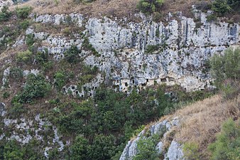
- 37.131615.015394 Filiporto Necropolis (From the car park, follow the path indicated by the signs). It is a necropolis composed of a thousand tombs that extend on the slopes and in the Anapo basin on the southwestern side. The cave tombs belong to the last phase of the city that is to the IX-VIII century BC.
- 37.13282715.0175335 Defensive moat (Next to the parking lot of the Filiporto necropolis). Shortly after the "saddle of Filiporto", a narrow strip of land that connects the plateau of Pantalica, there is the Pantalica gate, which is now partially visible through an entrance and traces of an ancient moat. All around the archaeologists have also found the signs of fortifications from the Byzantine era, a sign that the area was also fortified in the epochs following the pre-Greek ones. Along the door continue towards the village of San Micidario.

The Pantocrator of the oratory of San Micidario


- the church of San Micidario

The oratory of San Nicolicchio with frescoes
- 37.13236715.026297 San Nicolicchio village (Continuing along the path of San Micidario, or coming from Anaktoron). Located at the foot of the Anaktoron, the small village of San Nicolicchio takes its name from the oratory decorated with traces of frescoes, unfortunately quite ruined. However, the figures of Sant'Elena and Santo Stefano are recognizable. The dating seems to be from the 7th century.

The Anaktoron seen from above
- 37.13433615.0256678 Prince's Palace (Anaktoron) (Take from Ferla
 and turn to the indications).
  The Anaktoron building is still a kind of mystery to this day. It is a stone construction dating back to the 12th-11th century BC. where there are no similar works except tombs dug into the rock or simple huts. It has therefore been hypothesized that it was the palace of the local prince or even the coffer whose construction attracted Mycenaean workers, since they have been known to have traded with Sicily since ancient times. In the Byzantine era it was reused by making changes, but in later times it was abandoned.

- 37.13549515.0224829 Northwest Necropolis (The necropolis is visible along the or from the Calcinara valley but there are no safe paths to reach it). One of the oldest necropolis in the area (XII-XI century BC).
- 37.1397915.0291310 North Necropolis. The largest and densest necropolis of Pantalica, dating back to the 12th-11th century BC. it is clearly visible from the belvedere at the end of the or by accessing from the entrance on the Sortino side.
- 37.138115.033211 Cavetta necropolis (Going through the take the path on the right). Necropolis of the IX-VIII century BC with the presence of Byzantine houses. The path where the necropolis of Cavetta is indicated actually leads to a panoramic point where it is possible to partially see the confluence of the Anapo with the Calcinara. The necropolis is partially visible in front, beyond the street level. Some cave dwellings can also be reached from the path in the curve of the . The remaining tombs of the Cavetta are visible from the path of the Cave found.
Entrance of the Church of the Crucifix
Cavetta necropolis from the Cavetta path
tombs of Cavetta from the path of the Grotta Trovata
- 37.14083215.03186412 Church of the Crucifix (At the end of the from Ferla go down the Calcinara path). This small rock environment was used as a Byzantine church. Inside it is recognizable a rectangular apse with the remains of a crucifixion fresco as well as the representation of St. Nicholas and an anonymous saint. Continuing along the path you go down to the Calcinara stream and it is possible to rejoin the path on the Sortino side as well as go to the Cave of the bats.
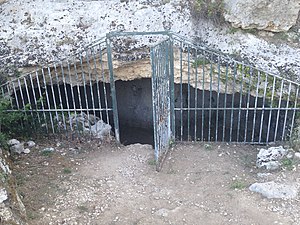
- 37.13909515.03288613 Cave found (Once you have taken the path to the Church of the crucifix and the Calcinara, turn immediately right). The narrow path leads to the Grotto found a karst cave with a narrow entrance for which it is necessary to crawl. To enter it is obviously useful to be equipped and experienced. Along the way, opposite, the tombs of the Cavetta necropolis.
- 37.1326414.98596614 Byzantine tanneries, Wood of Giarranauti (Follow the path indicated by the main path). Although only traces remain on the ground, tubs and buschi for tools, the ancient tanneries used by the inhabitants of Pantalica in the Byzantine era are visible.
- 37.13533814.99078615 Byzantine settlement of Giarranauti (From the main path, turn north-west). Along the path to the north-west is a Byzantine village where the foundations of a church and some stone houses are visible.
- 37.13205814.99084216 Ancient oil mill. Traces on the rock of an ancient Byzantine oil mill.
- 37.13838615.0069517 Ancient sheepfold (At the forestry building). Ancient stone sheepfold with fence.
- 37.13836315.00634318 Giarranauti houses. Ancient farm with fences for livestock today used by the forest.

The former station of Pantalica
- 37.12993515.02393319 Former station of Pantalica (along the route of the former railway). This old building along the railway line was the Pantalica station from which the steam trains that reached Vizzini passed. Today its rooms house a small museum of peasant life objects.
Where to eat
Where to sleep
Safety
How to keep in touch
Telephony
Several paths can fall into areas without a telephone network.
Note
- : The difference in height means the total difference in height of the stage, there may be higher differences in height both downhill and uphill within the stage.
 : Travel times are indicative and refer to an average hiker.
 : The classification adopted is the following:
 | Draft : the article respects the standard template and has at least one section with useful information (albeit a few lines). Header and footer are correctly filled out. |