| Vennbahn (RAVeL 9) | |
.png/210px-Vennbahn-Schild_(transparent).png) | |
| Information | |
| Departure | Aachen |
|---|---|
| Steps | (48,4 km) Montjoie (43,7 km) St. Vith |
| Arrival | (32,3 km) Three Virgins |
| Length | 124,4 km |
| Country | |
| Regions | Eifel High Fens Liège Ardenne Oesling |
| Official site | |
&groups=_797f25f2c7f1092929824877d9fefb3382683361)
The Vennbahn, literally “Fagnes railway line”, is a trans-European cyclo-pedestrian route with a high level of safety and very high ride qualities.
Understand
This cycle route is part of the network RAVeL. Formerly known in Belgium under the name of "RAVeL 9", it occupies the former base of the railway lines nbone 48 (Aix-la-Chapelle - Saint-Vith) and 47 (Saint-Vith - Troisvierges) of the SNCB.
From Rothe Erde station to Aachen to the Belgian-German border at Raeren, it is managed and maintained by the Aachen urban region then by the General Operational Directorate of Roads and Buildings in Wallonia to the Belgian-Luxembourg border at Huldande and finally by the administration of the Ponts et Chaussées in the Grand Duchy of Luxembourg to the station of Three Virgins.
Profile
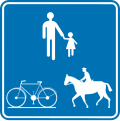
- Access : According to the law, the RAVeL network is considered as a network of “reserved paths”. That is to say that it has specific police regulations, not being considered a pedestrian zone, games are therefore authorized there but users cannot put each other in danger or hinder each other.
- always authorized: all types of bicycles, scooters and wheelchairs with or without electric assistance, Segways, roller skates, pedestrians, children's strollers, dogs (kept on a leash);
- sometimes authorized: riders (only walking and on certain sections in Belgium);
- still prohibited: all vehicles with thermal engines, couplings.
- Coating : 90% in asphalt or interlocking paving stones and 10% in compacted gravel for environmental reasons.
- Altitudes : minimum: 190 meters at km 0 to Rothe erde, maximum: 560 meters at km 61.5 at Sourbrodt.
- Slopes : average of 2% with a maximum of 3% except for 2 portions of 100 meters and 150 meters at 10% (Belgian-Luxembourg border).
- Security : in Germany and the Grand Duchy of Luxembourg: entirely on its own site, in Belgium: a few short sections on local or rural roads. Unless otherwise indicated, the right of way must be yielded at intersections with other roads on the entire route.
Signage and markup
The entire route is marked, like the entire RAVeL network, in blue and yellow except in the Grand Duchy of Luxembourg where it is white and green.
Main beacon all along the route

Secondary beacon in Belgium

Numbering in Belgium

Secondary tag and numbering in Luxembourg
Authorized riders

Riders prohibited

Secondary beacon for rider


.jpg/150px-Ravel_L.48,_St.Vith-Aachen_(Vennbahnradweg).jpg) | Typical crossing between a RAVeL and an ordinary road network in Belgium
|
Story
Steps
Aachen - Monschau
&groups=_c4b2faf966aa81778cecc3892428d2de6c2e4cb8)
- 1 Aachen (km 0) – departure of the 1 Aachen-Rothe-Erde station .
- Step of 22,2 km
- 2 Raeren (km 22.2)
- Step of 26,2 km
- 3 Montjoie (Monschau) (km 48.4)
- Step of 26,7 km
- 4 Waimes (km 75.1)
- Step of 17 km
- 5 St. Vith (Sankt Vith) (km 92.1)
- Step of 14,7 km
- 6 Burg-Reuland (km 106.8)
- Step of 17,6 km
- 7 Three Virgins (km 124.4) – Arrival at the 2 Troisvierges station .