 | ||
| Verwall | ||
| federal state | Tyrol | |
|---|---|---|
| Residents | unknown | |
| no value for residents on Wikidata: | ||
| height | 3,168 m | |
| no tourist info on Wikidata: | ||
| location | ||
| ||

The Verwall group, also Verwall or Ferwall lies in roughly equal parts in the Tyrolean Oberland and in Arlberg area, the mountain range is part of the Central Alps. While in the renowned winter sports resorts Ischgl, Galtür, St. Anton and Schruns the ski party is raging right at the border of the area, the Verwall is recommended even in summer for mountain lovers who are looking for peace and quiet.
Regions
According to the alpine club leader, the mountain group becomes one more western Verwall group and into one eastern Verwall group with the limit over that Muttenjoch divided, but this is of little importance for the normal mountain tourist.
places
The Verwall itself does not have any larger towns, but the settlements in the border valleys are the "Who's Who" of Austrian winter sports:

- Bludenz, District capital;
- Galtür, winter sports resort with guaranteed snow and summer health resort;
- Ischgl, Winter sports resort and climatic health resort;
- Kappl, Winter sports;
- Schruns, Capital of the Montafon;
- St. Anton, Winter sports resort on the Arlberg Pass;
Other goals
background
The Verwall borders in the north with the Klostertal and Stanzer Tal in the Arlberg area to the Lechtal Alps, to the southeast with the Paznaun Valley to the Samnaun and in the south and west in the Montafon to the Silvretta group and the Rätikon.
The name of the mountain comes from the Romanesque "Val bel", which means "beautiful valley". Geologically, the area belongs to the Silvretta crystalline (gneiss, mica schist, phyllite, granite gneiss and amphibolite), formed from the 1.5 billion year old rubble from even older mountains. It is therefore much older, for example the rocks of the Northern Limestone Alps.
The Verwall mountains are less glaciated than in the neighboring one SilvrettaThe high valleys of the mountains are comparatively easy to access from the surrounding tourist resorts and thus enable even the persistent hiker to experience the nature of the high mountains without too much difficulty. A well-marked network of trails leads from hut to hut and enables extensive high-altitude hikes on alpine paths, past ibex, marmots and alpine roses;
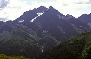
 North view from Patteriol over the Verwall: in the background almost to the left the Rote Wand (rock) in the Bregenz Forest, Lechtal with Lech and Zürs almost in the center of the picture and Lechtal Alps with Valuga (built up) over St. Anton three quarters to the right |
language
getting there
By plane
The nearest airport is in innsbruck;
By train
In the street
- From east via the Inntal motorway and Landeck;
- Of west via the A 14;
mobility
Tourist Attractions
mountains
The Verwall has eight mountain peaks above the "three thousand mark" and over 200 other peaks.
- High Riffler, (3168 m), highest peak in the group, access on the normal route for experienced mountain hikers possible from the Edmund-Graf-Hütte base;
- Cake topping, (3148 m)
- Küchlspitze, (3147 m)
- Plain maple, (3129 m)
- Sea heads, (3061 m)
- Patteriol, (3056 m), the most beautiful summit of the group. The ascent on the normal route is also an ambitious goal for the "normal mountaineer" because of several I-er and II-er climbing points. Demanding climbing routes; Base Konstanzer Hütte.
- Hem tip, (3039 m)
- Little Riffler, (3014 m)
- Scheibler (2978 m), summit ascent for experienced mountain hikers over the Kuchljoch from the Konstanzer Hütte or Darmstädter Hütte;
Valleys
- Verwall valley, End of the valley in St. Anton; Road to the Salzhütte, closed to public traffic during the day (from 8 a.m. to 6 p.m.), but there is a regular bus from St. Anton to the Salzhütte just behind the Verwallsee;
- The Rosanna Gorge is located at the valley exit near St. Anton. The Gasthaus Verwall is located at the Verwall reservoir, zur Constance hut at the confluence of the Fasulbach and the Rosanna approx. three hours' walk from St. Anton.
- Moostal, End of the valley in St. Anton at the Rendlabahn;
Lakes and bodies of water

- Warehouse Verwall in the Verwall valley;
- Memory cartel, (2020 m), in the Mosstal, surface 32 ha, in operation since 2005; Part of the hydroelectric power plant cartel; Info to the power plant;
activities
High trails
- Eastern Verwall Höhenweg: Edmund Graf House - Niederelbehütte - Darmstädter Hütte - Friedrichshafener Hütte;
- Verwall circuit: eight-day hut tour: Edmund-Graf-Hütte, Niederelbehütte, Darmstädter Hütte, Friedrichshafener Hütte, Neue Heilbronner Hütte, Konstanzer Hütte and Kaltenberghütte; Tour description as pdf;
Ski touring
- Verwall crossing
Mountain bike
- Transalp
kitchen
accommodation

list of Mountain huts of German Alpine Club (DAV) and des Austrian Alpine Club (OeAV) and Swiss Alpine Club (SAC) as well as private huts for hikers, mountaineers and mountain bikers (as of March 2007).
Because of the generally favorable accessibility and thus easy management, the huts are quite comfortable despite their altitude.
- Darmstadt Hut, (2384 m) (DAV Darmstadt), ascent from St. Anton (1304m) in about 3.5 hours, from Ischgl (1377m) via the Doppelseescharte in 4-5 hours.
- Hut telephone: 0043 - (0) 699/154 463 13; info
- Edmund Graf Hut, (2375 m) (PES section Innsbruck)
- Friedrichshafener Hut, (2138 m) (DAV section Friedrichshafen)
- Heilbronner Hut, (2320 m) (DAV section Heilbronn)
- Kaltenberghütte, (2089 m) (DAV section Reutlingen)
- Kiel weather hut, (2809 m), bivouac box (DAV)
- Constance hut, (1708 m) (DAV section Constance) in the Verwall valley, ascent from St. Anton in approx. 3.0 hours, from Salzhütte in approx. 1.5 hours (bus);
- Augasse 1c, A-6719 Bludesch, hut telephone: 0043 - (0) 664/5124787; info;
- Niederelbehütte, (2310 m) (DAV section Hamburg and Niederelbe)
- Reutlinger Hut, (2395 m), self-catering hut (DAV)
- Worms hut, (2305 m) (DAV section Worms)
- Alpengasthof Dias (1863m),
- Tel .: 0043 - (0) 5445-6260 info, (1863 m) (private)
nightlife
- Become Après-ski is looking for, you will certainly find what you are looking for in the neighboring winter sports resorts.
security
- see article Rockclimbing - Also contains important information on the topic Mountain hiking;
climate
The weather hazards of the high alpine mountain climate with increased solar radiation, possible afternoon heat thunderstorms and sudden sudden weather changes apply.
literature
- Alpine Club card (1: 25,000) sheet 28/2, (for mountaineers); Price: 9.80 €; ISBN 392877736X ;
- Compass map (1: 50,000) Silvretta, Verwall group: hiking, biking and ski touring map No. 41; Price: € 7.50,ISBN 3854910479 ;
- Alpine Club Guide: Peter Pindur, Roland Luzian, Andreas Weiskopf: "Verwallgruppe", Bergverlag Rother, price: 22.90 €, 10th edition, 2005, ISBN 376331251X
Web links
- Info page for Verwall with tour suggestions;