 | ||
| Lechtal Alps | ||
| federal state | Tyrol | |
|---|---|---|
| Residents | unknown | |
| no value for residents on Wikidata: | ||
| height | 3,036 m | |
| no tourist info on Wikidata: | ||
| location | ||
| ||

The Lechtal Alps belong to the northern limestone Alps and are predominantly in North Tyrol and partly also in the Vorarlberg in Western Austria.
Regions
The western part of the Lechtal Alps belongs to the Arlberg area.
places

in the mountains

The places in the mountains are all mountain villages.
- Berwang, (1342 m) skiing area and tourism in the Berwanger valley;
- Emperor (1530 m), highest municipality in the Reutte district (Ausserfern) and the entire northern Limestone Alps.
- Gramais
- Bschlabs
- ground
In the adjacent valleys


In the north-west adjoining Tyrolean Lechtal:
- Steeg (1122 m)
- Elbigenalp (1039 m), main town in the valley, carving village and home of the Geierwally;
- Elmen (978 m, with the towns of Martinau and Klimm)
- Forchach (910 m)
in the Except far (north side):
- Weißenbach am Lech (885 m), starting point for tours in the Tiroler Lech nature reserve.
- Reutte (853 m) market town and capital in Ausserfern.
- Cheerfulness (944 m) on Lake Heiterwang;
- Ehrwald (994 m), winter sports community at the foot of the Zugspitze
- Lermoos (1004 m) holiday community and winter sports
In the south-east Gurgltal on the Fernpass route:
- Nassereith (843 m), holiday community and known for the carnival custom of the Nassereither Schellerlaufens.
- Tarrenz (836 m), historic mining site and Starkenberg Castle.
in the Upper Inn Valley on the south side:
- Imst, (827 m) district capital of the district of the same name and end point of the Fernpass route;
- Landeck (816 m), the district capital of the district of the same name;
in the Arlberg area on the southwest side:
- St. Anton (1304 m), one of the most famous vacation spots in western Austria.
- St. Christoph (1793 m) one of the highest alpine ski resorts.
- Zürs (1716 m), mountain village and noble ski resort.
- Lech am Arlberg (1444 m), winter and summer tourism.
- Warth (1,495), mountain village im Bregenz Forest
Other goals
background
The surrounding regions are the Lech Valley in the northwest Warth to Reutte to the Allgäu Alps there, in the southwest that Verwall, in the south that Upper Inn Valley to the Ötztal Alps there, in the southeast Gurgltal with the long-distance pass and the Mieming Mountains and in the northeast of the Except far to the Ammergau Alps down.
language
getting there
The surrounding valleys are easily accessible via traffic routes, which no longer applies to the villages in the mountains themselves. Especially in winter, routes on the roads in the interior of the mountains are always closed due to the weather and the risk of avalanches.
mobility
Tourist Attractions
Summit goals
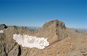
Parseier point
At 3,036 meters the highest peak in the mountains and also in the entire northern Limestone Alps.
Dawinkopf
(2970 m) second highest mountain in the Lechtal Alps.


Thaneller
The distinctive free-standing rock pyramid of the Thaneller (2,341 m) marks the northern end of the Lechtal Alps above the Zwischenentorental and is a much-visited summit in summer. The name is derived from "Fontanella" for a small fountain.
Rise off Berwang (1342m): little difficult mountain hike over around 1000 meters in altitude from the south side, the summit can be reached in a good three hours (or even faster) via a path through light mountain forest in the upper part of Schrofen Due to the southern exposure, the tour can get quite warm in the pine fields when there is strong sunshine.
Rise off Cheerfulness (994m, Werner-Rietzler-Steig): The route through the rugged north face of the Thaneller has a height difference of 1300 meters and is technically much more difficult than the tour from the south side with some climbing points secured by wire rope (I).
Ski tour: Also in winter as a ski tour from Heiterwang, but sometimes quite steep (in the transition to the normal route from Berwang) and also very vulnerable to avalanches.
There is no managed alpine pasture or mountain hut along the ascent routes.
Valleys
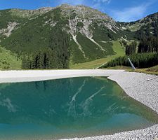
Lakes and bodies of water
- Upper Seewisee. 2469 m.
- Middle Seewisee. 2425 m.
Nature reserves
activities
Hiking and mountaineering
For hiking routes to the mountain peaks, see the respective Mountains
High trails
- Lechtaler Höhenweg. The crossing of the Lechtal Alps leads at altitudes between 2000 m and 2500 m with a length of around 105 km and in about one week over six huts through the entire Lechtal Alps from the Arlberg to Imst.
Via ferratas
- Arlberg via ferrata. The Arlberg via ferrata is an alpine classic and leads over the entire ridge of the Weißschrofenspitze (2,752 m, 47 ° 9 ′ 12 ″ N.10 ° 13 '40 "E). (For more detailed information, see the Arlberg area).
Winter sports
kitchen
nightlife
accommodation
List of mountain huts of the German Alpine Club (DAV) and des Austrian Alpine Club (OeAV) as well as private huts for hikers and mountaineers. Most of the huts are only open in summer (from May / June to October). Before the ascent, it is best to call the hut staff again to make sure it is really open. A reservation is useful and welcomed. But please cancel againif you don't come after all.
Some huts also have a winter room that is accessible outside of the opening hours. The hut key is then usually to be picked up from the responsible supervisory section.
1 Edelweiss House (Alpine Club Hut DAV Stuttgart), see the travel guide for details Emperor / Accommodation;

2 Ulm Hut (2,288 m, DAV section Ulm), P.O. Box 105, A-6580 St. Anton am Arlberg (above that Arlberg Pass). Tel.: 43 (0)5446 30200. Open: 2nd Saturday in July to 2nd Saturday in September, registration is essential..

The hut was inaugurated on September 5, 1903 and has been modernized repeatedly since then, the last time in 2003.
Equipment: 50 places in room dormitories, no mattress camps, 10 emergency dormitories, washrooms and showers;
In winter, the Ulmer Hut becomes a ski hut with a ski bar in the Arlberg ski area, Overnight stays are only possible with a valid ski pass.
Easiest boarding in summer: off St. Christoph (1768m), walking time: approx. 1.5 hours;
security
climate
literature
- : Lechtal Alps; Mountains - huts - tours - stories. Rosenheimer, 1990, ISBN 3-475-52637-9 ; 128 pages (German). (in the antiquarian bookshop)
cards
Alpine club cards
(1: 25,000, for hikers and mountaineers)
- German Alpine Club (Ed.): Alpine Club Card Allgäu Alps (Allgäu) - Lechtal Alps, Westblatt; Vol.2 / 1. ISBN 9783928777131 . 9,80 € for the Hochvogel, Hinterhornbach, Hermann-von-Barth-Hütte, Elbigenalp, Bretterspitze and Häselgehr regions
- German Alpine Club (Ed.): Alpine Club Map Allgäu Alps (Allgäu) - Lechtal Alps, eastern sheet; Vol.2 / 2. ISBN 9783928777148 . 9,80 € for the regions Hochvogel, Hinterhornbach, Hermann-von-Barth-Hütte, Elbigenalp, Bretterspitze and Häselgehr
- German Alpine Club (Ed.): Alpine club map Lechtal Alps / Arlberg area; Vol.3 / 2. 2010, ISBN 9783928777155 . 9,80 € for the regions around Warth, Lech and Lechtal, Klostertal, Arlberg and St. Anton, in the 3 / 2S version with ski tours
- German Alpine Club (Ed.): Alpine club map Lechtal Alps / Parseierspitze; Vol.3 / 3. ISBN 9783928777179 . 9,80 € for the regions Namlos, Bschlabs, Muttekopf, Mils, Imst, Heiterwand;
- German Alpine Club (Ed.): Alpine club map Lechtal Alps / Heiterwand and Muttekopf area; Vol.3 / 4. ISBN 9783928777186 . 9,80 € for the regions Namlos, Bschlabs, Muttekopf, Mils, Imst, Heiterwand;
Web links
- Tourist association Lechtal Tourismus: www.lechtal.at
- Imst-Gurgltal tourist office: www.imst.at