Aetolia-Acarnania (Greek Αιτωλοακαρνανία, Etoloakarnanía) is located in western Greece in the geographic region Central Greece.
The region borders on the Ionian Sea in the west, and in the north forms the Ambracian Gulf the border to the region Epirus, in the south the Gulf of Patras and the adjoining Gulf of Corinth form the border to the peninsula Peloponnese. The region lies in the east Fokida(Phocis).

places

- 1 Amfilochia.


 in the Wikidata database") nicely situated small town on the Ambracian Gulf but without any real sights.
nicely situated small town on the Ambracian Gulf but without any real sights. - 2 Agrinio.
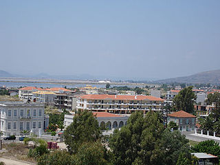
 largest city in the region, traditional center for tobacco processing, no major sights.
 - 3 Mesolongi.Capital of the region.
- 4 Nafpaktos.small port town on the Gulf of Corinth, once belonged to the Republic of Venice, site of the naval battle of Lepanto in 1571.


Other goals

Ancient sites
- 1 Kalydon (10 km east of Mesolongi): Ruins of the ancient city, including City wall, temple of Artemis Laphria, other sanctuaries. The setting of the ancient legend of the Calydonian boar.

- 2 Stratos: In the ancient capital of the Akarnan League and an important sanctuary of Zeus. You can see the remains of the 7.5 kilometer long city walls, the Temple of Zeus and the theater that once held 7,000 spectators.

- 3 Thermos: Remains of the ancient sanctuary of Apollo, the meeting place of the Aetolian League.
- 4 Pleuron (Πλευρώνα).Worth seeing ancient city in a beautiful scenic location.
Castles


- 5 Vonitsa Castle: Vonitsa is located on the south coast of the Ambracian Gulf, about 16 km southeast of Preveza. Due to its impressive view over the gulf and a small natural harbor, Vonitsa hill was fortified by the Byzantines and then by the Venetians and the Ottomans.
- 6 Grivas Castle: From the castle you have a unique view of the Ionian Sea, the Ambracian Gulf and the island of Lefkada. It was built in 1806 by Ali Pasha with the aim of facilitating the attack on Lefkada. Ali's plans were canceled in July 1807 when the French occupied the Ionian Islands under a treaty with the Russians. Soon after, Ali Pasha gave the castle to the von Grivas family, also the name of the castle. Before the castle was built, there was a Muslim monastery founded in 1668. For this reason the place was called Teke.
- 7 Agia Mavra fortress (Italian Santa Maura): One of the most impressive medieval buildings in Greece. It was built around 1300 for the Lombard ruler Ioanni Orsini after he married the daughter of the ruler of the despotate of Epirus Nikiphoros I and received the island of Lefkada (Leukas) as a wedding gift.
- 8 Andirrio fortress (ancient Greek Antirrhion): Andirrio played an important role in the Byzantine and post-Byzantine periods due to his strategic position. Andirrio followed Nafpaktos ’fate when it was abandoned in 1499 in the first year of the Venetian Turkish War. At that time, Sultan Bayezid II recognized the strategic importance of the strait and secured the entrance by building two forts on both capes on ancient foundations. The fortress Andirrio experienced several destruction and restorations. The castle is not far from the Rio-Andirrio Bridge and worth a visit.
- 9 Nafpaktos fortress
 (Italian Lepanto): The well-preserved castle of Nafpaktos is one of the most beautiful castles in Greece. The picturesque city walls enclose the small harbor. The fortress went through many phases, beginning in antiquity, went through the Venetian conquest and finally passed to the Ottomans.

Other structures
- 10 Rio-Andirrio Bridge: The approximately 2.9 km long cable-stayed bridge is the only fixed road crossing over the Gulf of Corinth, between the Peloponnese and the Greek mainland. It was inaugurated in 2004 and is a masterpiece of engineering, as building bridges here was associated with considerable difficulties, and for a long time was considered impossible.
.jpg/350px-Rio-Antirrio_Ferries_-_panoramio_(70).jpg)
Waters
- 11 Trichonida lake: large natural lake between Agrinio, Nafpaktos and Mesolongi.
.jpg/350px-Τριχωνίδα_(3).jpg)
- 12 Kremasta reservoir

background
The regions of Aetolia (also Aitolia written; modern greek Etolia) and Acarnania (Akarnania) already existed in antiquity. Aetolia is the southern and eastern part of the region, on the north bank of the Gulf of Patras and the Strait of Rio-Andirrio, which "guards" the access to the Gulf of Corinth. Akarnania, on the other hand, is the western and northern part, on the Ionian Sea and the south side of the Ambracian Gulf. The river Acheloos forms the traditional border between Aetolia and Akarnania.
The island Lefkada(Leukas) historically belongs to Akarnania, but is considered separately both according to the modern administrative structure and for the purposes of this travel guide and is counted among the Ionian Islands.
After Greece gained independence, Aetolia and Akarnania were combined to form the Aetolia-Akarnania Prefecture in 1833 - the largest prefecture in the country. Since the administrative reform in 2011, it has had the status of a regional district. At around 5,500 km², Aetolia-Akarnania is about the same size as the canton of Valais or twice as large as the Saarland, but has only 210,000 inhabitants.
Antiquity
The city-states (poleis) Akarnaniens formed in the 5th century BC. The Akarnan League. Whose capital was Stratoswhich also had an important sanctuary of Zeus. It is therefore the most important ancient site in the region. In the Peloponnesian War, Akarnania sided with Athens, while the opposite Ambrakia fought on the side of the Spartans. At the Battle of Olpai in 426 BC The Athenians and the Acarnanians were victorious. The Aetolian Confederation was in the 4th century BC Founded in BC and only gained in the 3rd century BC Historical significance.
In Hellenistic times, both Aetolia and Acarnania were established around 200 BC. On the side of the Roman Republic, which was supposed to protect them from the expansion of the Kingdom of Macedonia. After the death of Julius Caesar, the war for supremacy in Rome in 31 BC broke out. BC off the coast of Akarnania to Sea battle at Actiumwhich ended with a decisive victory for Octavian over Mark Antony and Cleopatra of Egypt. Octavian then took power throughout the Roman Empire, took the name Augustus and became the first Roman emperor. At the same time, Aetolia and Acarnania (which until then pro forma were still independent) in the Roman province Achaea incorporated.
Middle Ages and Modern Times
After the collapse of the Byzantine Empire in 1204 at the time of the Crusades, Aetolia and Acarnania belonged to the Despotate Epirus. Its last capital - before the annexation by the Ottoman Empire - in the 15th century was Angelokastro (today only a village in the municipality of Agrinio).
The Republic of Venice had a base in the 15th century Nafpaktos (Italian Lepanto). In the 16th century the coasts of the area between the Ottoman Empire and Christian-European powers (namely Venice and Spain) were fiercely contested. This culminated in the 1571 Battle of Lepanto, the last great and extremely bloody galley battle in the Mediterranean.
In the phase around 1800 the area belonged to the rulership of the Ali Pasha of Ioanninawho was formally a governor of Constantinople, but in fact made himself largely independent.
language
getting there
By plane
At Preveza, in the northwesternmost tip of the region, there is the medium-sized one 1 Aktion-Preveza airport![]()
![]()
![]() (IATA: PVC). Direct flights from German-speaking countries also land there, at least seasonally, among others. With Condor, Easyjet or Austrian Airlines.
(IATA: PVC). Direct flights from German-speaking countries also land there, at least seasonally, among others. With Condor, Easyjet or Austrian Airlines.

For the south of the region, however, is the smaller Araxos airport /Patras (GPA) closer (approx. 70 km from Nafpaktos, 90 km from Messolongi), the seasonal z. B is served by TUI fly from Germany.
By car
The region can be reached from Peloponnese in the south about the Rio-Andirrio Bridge at Patras, it connects the A8 (Olympia Odos) with the A5 (Ionia Odos) that is under construction.
In the north, the N18 leads from Igoumenitsa to the Ambracian Gulf and then passes under Preveza the strait in a tunnel. In future, an alternative is the one under construction A5, it comes from Ioannina and goes inland through the region towards Patras.
Only a few roads lead from the interior to the east Etoloakarnania, the most important comes from Delphi and walks along the coast of the Gulf of Corinth.
mobility
Public transport is rare in the sparsely populated region. Buses from the regional transport cooperative KTEL Aitoloakarnanias even drive between the larger towns a maximum of 4–5 times a day, on weekends only once or not at all. A car is therefore highly recommended, if not absolutely essential, for making excursions within the region.