 | ||
| Peloponnese | ||
| Country | Greece | |
|---|---|---|
| The search for a province ends with the state | ||
| Residents | unknown | |
| no value for residents on Wikidata: | ||
| height | 2,407 m, 994 m | |
| no tourist info on Wikidata: | ||
| location | ||
| ||

The (often also: the) Peloponnese located in the south Greece. Although they are through the artificial Corinth Canal is separated from the mainland, it represents a peninsula and forms the extension of the Balkans.
background
The Surname the Peloponnese means something like "island of the Pelops". Pelops is a mythological king who made up large parts of Elis and Arcadia conquered. Later the whole peninsula was named after im. You can see Pelops on the east gable of the Temple of Zeus in Olympia.
The Peloponnese is apart from Crete the southernmost Greek region. The temperatures are around 3 ° C higher than on the mainland. Nevertheless, the mountains, which are up to 2,400 m high, allow around 20 ski areas. Even if the length of their slopes cannot compete with those of alpine areas, they are mostly in operation from the end of December to mid-March.
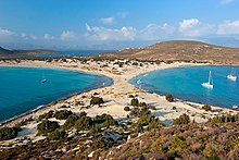
The Peloponnese is an ancient cultural land and offers unique archaeological sites from antiquity and the Middle Ages. Mycenaeans, ancient Greeks, Romans, Byzantines, Venetians, Franks, Ottomans, French and English have left their mark on the region. The peninsula also has a lot to offer in terms of landscape: the spectrum ranges from beautiful beaches to wide plains to high mountains.
Regions

The Peloponnese is made up of the following prefectures:


places


- 1 Patras.


 in der Datenbank Wikidata") Patras is after Athens and Thessaloniki the third largest city in Greece and has an important port, which is particularly convenient for ferry connections to Italy. The city at the entrance to the Gulf of Corinth is often only approached by tourists as a transit station, but it also has some sights to offer.
Patras is after Athens and Thessaloniki the third largest city in Greece and has an important port, which is particularly convenient for ferry connections to Italy. The city at the entrance to the Gulf of Corinth is often only approached by tourists as a transit station, but it also has some sights to offer.

- 2 Corinth.The city on the Isthmus of Corinth of the same name is now a noisy and modern Greek city. The fortress of Akrocorinth is impressively located on a mountain above the city. The archaeological site of ancient Corinth is also waiting to be explored.


- 4 Tripoli (Τρίπολη).
 Tripols is beautifully located on the edge of a plateau, you can find comparatively good shopping opportunities and the city is at the crossroads of important roads - which would also describe the city's tourist advantages.

- 5 Nafplion.Nafplion was once the first capital of Greece. The Palimidifestung towers majestically over the old town and offers a beautiful panoramic view of the Argolic Gulf. Although the city is firmly in the hands of tourists, it has a unique flair. Restaurants, cafes, boutiques, souvenir shops and guest houses are lined up in beautifully restored houses.

- 6 Pylos
 (Πύλος). The small fishing village, where tourism has long since arrived, is located in the southwest of the Peloponnese. The village nestles nicely on a slope and offers many places a beautiful view over the historically important bay. In the immediate vicinity there are beautiful beaches, the Palace of Nestor and a ruined fortress of the Venetians and an aqueduct that is well worth seeing.

- 7 Kalamata.The noisy city of Kalamata is the economic center of the southern Peloponnese. The famous Kalamata olive oil also comes from the surrounding area. In addition to the old town and the large pebble beach, the city offers a good starting point for day trips. In front of the castle ruins with its rich history on a rocky hill in the northwest of the city of Kalamata you have a wonderful view of the city. On the hill there was an ancient acropolis before the Trojan War and later a Byzantine fortress. The ruins, from today, are the remains of the castle, which was (re) built there during the Frankish occupation at the beginning of the 13th century.


- 9 Stoupa (Στούπα Μεσσηνίας).Small seaside resort at the entrance to the Mani. Characterized by smaller hotels and pensions, many holiday homes and apartments. Since there are no large hotels, the place is still charming and a bit sleepy even in high season. There are two beaches right in the village, "Kalogria" is one of the most famous in Messinia because it has wonderfully fine sand. In the immediate vicinity there are two other beaches, mostly with gravel. The landscape invites you to go hiking - but better not in hot summer. Nice trips, for example with the rented scooter, go to Agios Nikolaos, Kastania, Kardamyli.


Other goals
Highlights
- Cities: Patras, Naphplion
- Ancient sites: Mycenae, Olympia, Epidaurus
- Castles: Methoni, Monemvasia
- Landscapes: Mani Peninsula, Louisos Gorge
- Monasteries: Agia Lávra, Méga Spileo
Archaeological sites


.jpg/400px-Nestor_Palace_-_panoramio_(1).jpg)


.jpg/400px-Asclepeion_Ancient_Messene_(3).jpg)


.jpg/400px-Archaeological_site_of_the_Temple_of_Athena_Alea_at_Tegea_(2017,_image_1).jpg)
Mycenaean culture (approx. 1600-1100 BC): All over the Peloponnese there are archaeological sites that testify to many past cultures. The most important sites of the Mycenaean culture are:
- 1 Mycenae.was one of the most important cities in Greece in the pre-classical period, after which the Mycenaean culture was named. Preserved and excavated today are, inter alia. the ruins of the Mycenaean upper town. The remains of the cyclopean curtain wall and the lion gate are worth mentioning.

- 2 Tiryns.Tiryns was an important Mycenaean settlement. 1.5 km from the sea, it controlled the trade routes between the mainland and the centers of the Aegean Sea. It is believed that Tiryns acted as the port of Mycenae, largely because it never achieved its fame. Today Tiryns is a well-known but little-visited archaeological site.
- 3 Nestor's Palace (Ανάκτορο του Νέστορα).Remains of a large Mycenaean palace and administrative center from the late Helladic period.
- 4 Heraion of Perachora (Ηραίον της Περαχώρας).is a sanctuary of the goddess Hera in a small bay of the Corinthian Gulf at the end of the Perachora peninsula. In addition to a Hera temple of unusual design, remains of a number of other structures were found, including an L-shaped stoa, a large cistern, dining rooms and a second potential temple. The sanctuary of Hera in Perachora is 14.2 kilometers northwest of Corinth and 75.9 kilometers west of Athens. Although there are debates between Argos, Megara, and Corinth, the sanctuary was likely under the control of Corinth as it was outside the ports of this powerful city across the Corinthian Gulf. Cult activity in this place may have lasted from the 9th century BC. Until 146 BC When the Roman general Mummius sacked Corinth during the war with the Achaean League. In Roman times, domestic structures were built on this site, indicating that the area was no longer a sanctuary. This place is significant in exploring the origins of Greek temple architecture and rural cults.
- 5 Pavlopetri (Παυλοπέτρι).youtube url used
 The sunken city of Pavlopetri off the coast of southern Laconia is about 5,000 years old, making it one of the oldest sunken cities and the oldest in the Mediterranean.


Hellenistic-Roman: The ancient sites sometimes show different phases of Hellenistic (750-146 BC) and Roman rule (146 BC-395 AD). Important sites are:
- 6 Olympia.was the sanctuary of Zeus. It was the site of the ancient Olympic Games. On the edge of the ancient sanctuary is the modern city of Archea Olymbia.
- 7 Epidaurus.is the most important ancient place of worship for the healing god Asklepios (Asklepieion) and his father Apollo in Greece. The well-preserved theater is particularly well-known. It has been a UNESCO World Heritage Site since 1988.


- 8 Messene.This ancient city, unlike most of the others, remained untouched by the later settlements and is therefore superbly preserved. The excavation of this site was relatively recent compared to the sites of Epidaurus and Delphi, which explains why it is still a little-known destination. Even so, the archaeological site of ancient Messene is arguably one of the most impressive given its size. The site has been continuously excavated for the past 100 years, but only a third of its total size has been completed so far!

- 9 Temple of Apollo at Bassae (Ναός Επικούριου Απόλλωνα).is a UNESCO World Heritage Site and is the second best preserved Greek temple in the motherland (after the Hephaisteion in Athens). It was consecrated to the god of healing Apollon Epikourios.

- 10 Mantineia (Μαντίνεια).Ancient Greek city with an eventful history. Today some excavations can be visited. Scenic location.

- 11 Nemea (Αρχαία Νεμέα Κορινθίας).A heroon (probably of Opheltes) from the early 6th century BC is still from the sanctuary. Chr. As well as some treasure houses, also a large bath for the athletes with several wash troughs. The main attraction of the sanctuary was and is the Temple of Zeus.

- 12 Villa of Herodes Atticus (Έπαυλη του Ηρώδη του Αττικού).ancient Roman villa of Herodes Atticus, on the outskirts of the municipality of Doliana.

- 13 Tegea (Τεγέα).was one of the oldest and most powerful cities in the Arcadia of ancient Greece.
.jpg/350px-Archaeological_site_of_the_Temple_of_Athena_Alea_at_Tegea_(2017,_image_1).jpg)
Eastern Roman-Byzantine: From the Byzantine period (395-1204) there are still some fortifications that were subsequently used by Franks, Venetians, Ottomans and others. B .:


- 14 MethoniMethoni Castle - actually a fortified city - is one of the most important and beautiful castles in Greece. It was built by the Venetians after 1209 in a strategic place on a rock that crosses the sea and is separated from the land by an artificial moat.

- 15 Monemvasia, Monemvasia is one of the most important medieval fortified cities in Greece. It is also one of the most beautiful castles in the world. The area consists largely of a large plateau about 100 m high, up to 300 m wide and 1 km long. Here is a mighty medieval fortress. The city wall and many Byzantine churches date from the Middle Ages.

- 16 Chlemoutsi Castle: Chlemoutsi is a medieval castle built by the crusaders of the Principality of Achaia as the main fortress and is perhaps the most beautiful fortress of the early Franconian period in Greece.

- 17 Karytaina Castle: The castle was built during the Frankish occupation in the 13th century (probably in 1245) by the famous French knight Geoffroy de Briel, Baron von Karytaina. De Briel, born in Greece, is one of the leading figures in the Chronicle of the Morea.

- 18 Kyparissia Castle: Kyparissia Castle is also known as Arcadia Castle, the city's medieval name. It was built by the Franks on the site of an earlier Byzantine fortress. It became one of the most important castles in the Franconian Morea.

- 19 Androusa Castle: The high point in the history of the castle is that it was the seat of the notorious mercenaries of the "Navarrese Company", who were the last Franconian rulers of the Principality of Achaia. At that time, towards the end of the 14th century, it was one of the most important castles in the Peloponnese.
- 20 Niokastro Fortress (Pylos): Niokastro was built by the Turks in 1573 and conquered by the Venetians in 1686. In 1715 it came under Turkish rule again, together with the Koroni and Palionavarino castles. In the vicinity of Pylos there is the older castle of Navarino, called Palaiokastro or Palaionavarino, which is also well worth seeing.
- 21 Koroni fortress: A castle with impressive fortifications at the southwest end of the Peloponnese, which has existed since the 7th century AD and was completed and reconstructed by the Venetians in the 13th century. The city flourished in the centuries that followed, but it was constantly in the midst of the long conflict between the Venetians and the Turks.

- 22 Geraki Castle: Geraki castle ruins were built by the Franks on a low hill on the southeastern slopes of Mount Parnon. It was once one of the most important castles in the Peloponnese.
- 23 Argos Castle: One of the ancient castles in Greece. The place had been fortified since prehistoric times and remained a powerful fortress through the Classical and Middle Ages until the 19th century.
There are many other castles and fortifications, some of which are very nicely located, on the Peloponnese, a map here.
Monasteries
,_view_from_Greek_Independence_War_monument.jpg/400px-Agia_Lavra_monastery_(September_2016),_view_from_Greek_Independence_War_monument.jpg)


The monasteries of the Peloponnese are sometimes very old and are often worth a visit. In the past, some monasteries - especially during the Ottoman rule - played an important role in the transmission of Greek customs and the language and formed the nucleus of the beginning Greek struggle for freedom. Significant and beautifully located monasteries are:
- 1 Taxiarchis. famous monastery near Aigio.
- 2 Méga Spileo.The three lowest floors fill the space of a cave, the higher ones were glued like swallow nests to the approximately 190 meters rising rock wall. In the church on the second floor, a picture of Mary is shown as the work of the apostle Luke, to whom the monastery owes its reputation as a place of pilgrimage. The monastery, which, according to the founding legends, dates back to the 4th century, was re-established in the 13th century by the Empress Euphrosyne and received its present form in 1640. At the turn of the 20th century, it was considered the largest and most respected monastery in Greece with (1889) 109 Residents. On December 8, 1943, it was destroyed by the German Wehrmacht, and 22 monks and visitors were also murdered. The monastery makes a very modern impression from the outside, it was rebuilt around 1950. Opinions can be divided about the architectural style. Photographs should not be taken inside the monastery walls, under no circumstances with a flash. The monastery church has a bronze portal that is well worth seeing, also note the icons and the rather somber-looking painting of the dome from 1653. Liturgical vestments and vessels are on display in the monastery museum. One floor below you get into the cave, the local spring is said to have healing effects.
- 3 Agia Lávra.It was built in 961 on Mount Gelmos at an altitude of 961 meters. It is one of the oldest monasteries in the Peloponnese as well as a symbol of the independence of Greece. The flag of the Greek Liberation Army was blessed here on March 25, 1821. The Greek national holiday on March 25th goes back to this date. The monastery was partially destroyed in World War II and rebuilt around 1850.
- 4 Emialon.,.One of the most beautiful, albeit less known, monasteries. It was founded in 1608 and originally built into the rock where today the visitor can see many of the ruins of the first cells. An open-air museum on the subject of hydraulic engineering is also worth a visit nearby.
- 5 Prodromou and Filosofou. and other interesting monasteries near Dimitsana.
- 6 Loukous.The monastery near Astros is actually called Moni Metamorphossis Sotiros Loukous. The Transfiguration Monastery is still inhabited by a few nuns. In the center of the complex is a cross-domed church, built around 1400, the stones are from antiquity and come partly from a sanctuary, partly from a nearby villa of Herodes Atticus. On the approach to the monastery you pass the remains of an aqueduct, which has been given a mysterious appearance by sintering and is at least as worth seeing as the monastery itself.


Landscapes


.JPG/400px-Lake_cave_(1).JPG)


- 1 Vouraikós gorge (Βουραϊκός).The small river Vouraikós has its source in the Aroania Mountains (also Chelmos Mountains) and flows into the Gulf of Corinth in Diakopto. Hikes in the Vouraikós Gorge in the upper reaches of the river are quite popular. A narrow-gauge rack railway runs through the valley, the tracks of which have only been renovated in recent years.
- 2 Louisos Gorge (Λούσιος).The Lousios Gorge was formed by the Lousios river of the same name, a tributary of the Alfios. It has a length of approx. 5,000 meters and runs in a north-south direction. A well-developed and popular hiking trail leads through the gorge. The village is at the top of the gorge Dimitsana. At the bottom of the gorge is the ancient one Gortys with a freely accessible Asclepius sanctuary. The entrances to the gorge can be reached on foot or by car via serpentine roads. Gortys at the southern entrance can be reached from the junction from Elleniko-Stemnitsa street. A special feature are those built into the rock walls of the gorge Prodromou and Philosophou monasteries (old and new). The manuscripts and scrolls preserved from the Ottoman period are now kept in the museum in Dimitsana. The old Philosophou monastery directly in the rock face was abandoned in favor of the new one. The monasteries Prodromou and Philosophou (new) are still inhabited by monks today. Visitors are welcome provided they adhere to the dress code.
- 3 Taygetus Mountains (Ταΰγετος).Today the Taygetos Mountains are well developed for tourism. Quite a few hiking trails like that European long-distance hiking trail E4 invite you to extensive tours.
- 4 Mani Peninsula (Μάνη).The Mani, characterized by the up to 2,400 meter high Taygetos Mountains and its southernmost foothills, was a refuge for many people fleeing from foreign conquerors and for the same reason also ideal for pirates until the 20th century because of its impassability. Due to the special topography, the Mani was an area almost free from government interference and developed a special class of people with their own cultural form. Although there were individual churches in fortified places much earlier, Christianity did not really gain a foothold until the 9th century, when countless churches and small churches were built and some of them are still decorated with beautiful frescoes. However, none of the “occupying powers” over the centuries was able to suppress the manias, they always remained free, wild, unpredictable and at odds with one another, which is expressed in the sometimes very high maniotic defensive and residential towers. Family feuds spanning generations left their mark on the maniacs. It was precisely in this region that the beginnings of the Greek liberation from the 400-year rule of the Ottoman Empire were organized and started. Important tourist places are the one below Areopoli Itylo and the one to the north Stoupa on the sunny side of the Mani. The stalactite cave at Pyrgos Dirouwhich can be accessed by boat, as well as the village Vathia with twelve well-restored residential towers are among the main attractions of the Mani. Could one of the oldest places in Mani Kardamili already mentioned in Homer's Iliad.
- 5 Pirgos Dirou caves (Σπήλαιο Γλυφάδα Διρού).The stalactite cave at Pyrgos Dirou is one of three caves that are located directly on the sea in the Bay of Diros. The stalactite cave, also known as Glyfada or Vlychada, is open to tourists and one of the main attractions of the Mani Peninsula. Visitors can visit the cave on a 2800 m long boat trip of about 25 minutes and a subsequent 300 m long climb. The guides pound the boats through the rock labyrinth with narrow passages and large halls.
- 6 Kastania cave (Σπήλαιο Αγίου Ανδρέα Καστανιάς).large, very attractive stalactite cave.
- 7 Diro's cave (Σπήλαιο Γλυφάδα Διρού).A very nice cave system that is shown in an approx. 20 minute boat trip. Occasionally you have to bow your head because the ceiling is very low. The cave visitor shouldn't have claustrophobia. Allow for long waiting times.
- 8 Kapsia cave (Σπήλαιο Κάψια)..Interesting cave. Safe passage. The catchiest [if a little creepy] are the human bones of captured victims from the ancient past, bones have become one with the rock.
- 9 Kaiades cave (Καιάδας).Allegedly a place the ancient Spartans are said to have thrown disabled or infant babies to secure their eugenic race.
- 10 Lakes cave (Σπήλαιο Λιμνών).The very interesting cave is an old underground river, which consists of three levels. At the end of winter, when the snow melts, it turns into a flowing river with waterfalls. In summer it dries up and leaves 13 lakes behind.
- 11 Franchthi cave (Σπήλαιο Φράγχθι).The cave, which is well worth seeing, can only be reached via a 20-minute walk from Lambayana Beach in Fournier to the north. There is the officially signposted parking lot for the by no means barrier-free footpath to the Franchthi Cave.
- 12 Polylimnio water trap. Nature is breathtakingly beautiful. The completely undeveloped and little developed area is not (yet) overrun with tourists and invites you to relax and bathe in the refreshingly cool water. The path through the gorge is easy to walk, but the last stage leads up a steep path that requires time and some experience as well as good shoes. Be sure to bring your swimwear with you!
- 13 Neda waterfall (Νέδα).Beautiful waterfall with a small lake in beautiful surroundings. Only accessible on foot and via dirt road.
- 14 Stenosia & Kalamaris waterfalls. Great waterfall and small lake with a small rest area at the top, take sturdy shoes! You can walk down quite a long way, but not that easy with slippery passages. Not for elderly or disabled people! The Kalamaris waterfall and lake is about 2 km further east in the parallel valley. Very beautiful waterfall in a great landscape, also only accessible on foot.
- 15 Nemouta waterfalls. In this water-rich environment there are a number of beautiful waterfalls in wonderful surroundings. Accessible only on foot. The access to the falls is not easy. The signage is also patchy, so ask the villagers if you have any doubts. From Nemouta it goes in countless, sometimes very steep, serpentines into the beautiful valley. From the large parking lot you can then go to the waterfalls, a board shows the locations of the waterfalls. You should have sturdy shoes with you if you want to visit these beautiful, yet rather unknown waterfalls.


miscellaneous

- 11 Kalavryta (Σφαγή των Καλαβρύτων).The place Kalávryta, accessible from Diakopto via a winding country road and the rack railway, is the center of the municipality of the same name. The memory of the mass execution of the German military on December 13, 1943 is maintained by a memorial and by the Kalavryta City Museum.
- 12 Vatheia (Βάθεια Λακωνίας).The place Vathia mostly consists of less inhabited residential towers, which are concentrated like a fortress on the tip of a rocky promontory not far from the Messenian Gulf. Some residential towers are used as holiday apartments. The picturesque location of the place is also an attraction for tourists. Due to the special architectural value, the village was placed under monument protection. Preservation and restoration measures were carried out on selected building ensembles consisting of residential towers, oil mills and other buildings, and they were converted into small hotels and guest houses.
- 25 Corinth Canal (Διώρυγα της Κορίνθου).With a length of 6,346 m, the canal separates the Peloponnese from the Greek mainland. It was built in the years 1881-1883 and connects the Gulf of Corinth with the Saronic Gulf. The side walls of the canal have an angle of inclination between 71 ° and 77 °, they are over 80 m high at the highest points. However, the idea of building a canal at this point comes from ancient times. From 600 BC. up to 100 BC There was the Diolkos, a paved road with ruts on which ships were transported across the country. Finally, under the rule of the Roman Emperor Nero, construction of the canal began. The ruler died three months later and work was stopped again. Since the canal is only 24 m wide at the water surface, it is now mostly crossed by tourist ships and fishing boats. A good observation point is at Isthmia on a road bridge near the Isthmia Prime Hotel, it crosses the canal next to the A8 Athens - Patras motorway. The best time to observe is around 10 a.m. when the sun hits the surface of the water. There is an iron walkway under the road bridge, from where there is also bungee jumping.

_-_panoramio_(1).jpg/350px-Mani,_Grecia_(Agosto_2015)_-_panoramio_(1).jpg)

getting there
By boat
With the ferry Venice or significantly shorter and cheaper from Ancona, Brindisi, Trieste or Otranto. Arrival at the port of Patras.
1 Katakolo on the west coast is the port for cruise ships, which is mainly used for trips to Olympia.
By car
The highway A8 connects the Peloponnese near Isthmia with the Greek mainland, it comes from Athens and extends up to the coast of the Gulf of Corinth Patras. It has been fully developed since 2017, places are usually bypassed extensively, the road conditions are good. The rest of the traffic routing on the country roads is mostly single-lane, overtaking is sometimes possible. The driving style on this road along the north coast takes getting used to, even by Greek standards.
From the west coast of Greece you can get there via the Rio-Andirrio Bridge at Patras on the Peloponnese.
By plane
Inexpensive charter flights to Kalamata airport![]()
![]() (IATA: KLX) are available from German-speaking countries. The Athens-Eleftherios Venizelos Airport
(IATA: KLX) are available from German-speaking countries. The Athens-Eleftherios Venizelos Airport![]()
![]()
![]()
![]() (IATA: ATH) is served daily in scheduled services. With the S-Bahn Proastiakos to Corinth the Peloponnese can be easily reached.
(IATA: ATH) is served daily in scheduled services. With the S-Bahn Proastiakos to Corinth the Peloponnese can be easily reached.


mobility
It is advisable to make a round trip with your own vehicle. You can get to most of the sights by bus, but that is very time-consuming.
activities

beaches
The Peloponnese offers an endless number of beautiful beaches, some remote ones are also suitable as Naturist beaches. Some of the most famous and of course well-frequented beaches are:
- 1 Glyfa Beach (Γλύφα)..Very long sandy beach, not very crowded in places.
- 2 Kourouta Beach (Κουρούτα)..very well developed, very long sandy beach.
- 3 Zacharo Beach.very good, very long sandy beach, only partly with beach bars and loungers.
- 4 Romanos Beach. The landscape is very beautiful. Sandy beach with clear water.
- 5 Voidokilia (ox belly bay).circular bay with fine sand.
- 6 Golden Sand (Gialova Beach). elongated sandy beach in the immediate vicinity of the ox belly bay.
- 7 Kalamata Beach (Ανατολική Καλαμάτα 1 / Ανάσταση)..long, organized sandy beach with all tourist offers.
- 8 Foneas Beach..Great pebble beach with sunset parking and snack available. Clean.
- 9 Skoutari Beach. Beautiful beach. Park. Tavern clear water with gravel or sand.
- 10 Mavrovouni Beach. Long beach length, mostly organized, sand with not so shallow water.
- 11 Plytras Beach (Πλύτρα-Παχιάμμος)..Clear water and flat sand. Ideal beach for families with children.
- 12 Elafonisos - Simos Beach.it is a fascinating double beach and an impressive natural spectacle.
- 13 Karathona Beach (Καραθώνα)..Great, long beach, just outside of Nafplio. Lots of beach bars.
- 14 Tolo Beach (Τολό)..long, popular sandy beach.


hike
Also for hike there are many interesting trails, e.g. in the gorges mentioned above and to the waterfalls.
kitchen
See also: Eating and drinking in Greece.
Many dishes are prepared with a lot of oil and a lot of garlic and are usually characterized by a high proportion of meat. Lamb, chicken, beef and pork are offered in many varieties. Especially near the coast there is often a considerable selection of fish dishes, which are often a little more expensive than meat dishes. The Greek fishing grounds are so overfished that the fish has to be brought from far away. At the beginning of every meal you are given a basket of bread.
AppetizersOften found on the cards of a taverna are stuffed vine leaves, fried zucchini, tzatziki, seafood or tuna salad. The most popular Main courses are likely Giros, moussaka (Casserole made from minced meat, eggplant, potatoes) and Souvlaki (Pork or mutton skewers). Popular dessert are Baklava (Puff pastry filled with honey and nuts) and yogurt with honey.
language
Because of the large number of tourists, you can get by with English everywhere, German is also widely understood.
security
As in all of Greece, crime is very low and you can move around freely anywhere.
climate
Hot, dry summers and cool, mild winters. The difference in temperatures and rain is naturally high between the coast and the mountains. The season is from the end of April to mid-November.
| month | Jan | Feb | Mar | Apr | May | Jun | Jul | Aug | Sep | Oct | Nov | Dec |
|---|---|---|---|---|---|---|---|---|---|---|---|---|
| max temperature in (° C) | 14 | 15 | 17 | 20 | 25 | 29 | 32 | 32 | 28 | 24 | 19 | 15 |
| min.temperature (° C) | 6 | 6 | 8 | 10 | 15 | 20 | 22 | 21 | 19 | 14 | 11 | 8 |
| Precipitation (days) | 8 | 8 | 7 | 5 | 5 | 2 | 1 | 2 | 3 | 5 | 7 | 9 |
| Precipitation (mm) | 79 | 75 | 58 | 38 | 29 | 9 | 4 | 8 | 20 | 73 | 96 | 110 |
| Sunshine (hrs) | 4 | 5 | 6 | 8 | 10 | 11 | 12 | 12 | 9 | 7 | 5 | 4 |
| Water temperature (° C) | 15 | 14 | 14 | 16 | 18 | 21 | 23 | 24 | 23 | 22 | 19 | 16 |