 | ||
| Crete | ||
| region | Crete | |
|---|---|---|
| Residents | 623.065 (2011) | |
| height | 2,456 m | |
| Tourist info web | https://www.incrediblecrete.gr/de/ | |
| no tourist info on Wikidata: | ||
| location | ||
| ||

Crete is after Sicily, Sardinia, Cyprus and Corsica the fifth largest island in the Mediterranean Sea, belongs politically to Greece and is its largest island.
The island is one of the main tourist destinations in Greece, as it has to offer in abundance of everything, wonderful beaches, cities and villages worth seeing, impressive landscapes, archaeological sites, monasteries and an excellent tourist infrastructure.
Regions
The island can be divided into different regions, each with their own characteristics.
- North coast - This area of the island is the most popular tourist destination and offers the traveler a variety of options. Long sandy beaches, hotels and cities for every taste (large cities, more rural villages or places exclusively inhabited by tourists) attract holidaymakers to the island.
- South coast - The southern part of the island consists mainly of cliffs and has only a few sandy beaches. Some of the smaller towns there are only accessible by boat even now, and others are so far from the airport or offer so few accommodation options that they can hardly be found in catalogs. In the winter half of the year, however, the climate here is more stable and you can still swim in November.
- West Coast and East coast - The beaches and villages to be found here are mainly for individual travelers, as there are almost no hotels and the traveler is dependent on pensions or other overnight accommodations.
- Plateaus - The interior of Crete, which is very mountainous and partly rugged, has some plateaus that, in contrast to the lively coastal regions, offer peace and relaxation. Some of the plains are pure pastureland, others are used to plant typical Cretan, but also everyday products such as olives, grapes, tomatoes, cucumbers, spices or bananas.
places

Depending on the region, there are a wide variety of excursion destinations:
- In the North
- 1 Kíssamos-Kastélli.


 in der Datenbank Wikidata") With the beaches of Balos, Elafonisi and Falassarna, three of the most popular destinations in Western Crete are located near the city. Other sights include the Venetian fortress on the offshore island of Imeri Gramvousa, the Byzantine rotonda of the Archangel Michael in Episkopi, the Chrysoskalitissa monastery, the remains of the Temple of Artemis in Dyktina on the Rodopou, the ancient finds in Falassarna and Polyrinia.
With the beaches of Balos, Elafonisi and Falassarna, three of the most popular destinations in Western Crete are located near the city. Other sights include the Venetian fortress on the offshore island of Imeri Gramvousa, the Byzantine rotonda of the Archangel Michael in Episkopi, the Chrysoskalitissa monastery, the remains of the Temple of Artemis in Dyktina on the Rodopou, the ancient finds in Falassarna and Polyrinia. - 2 Chaniá.Second largest town in Crete with a ferry terminal and airport. The very beautiful harbor promenade and the old Venetian harbor are the main attractions.
- 3 Rethymnon.After Heraklion and Chania, it is the third largest city on the island and a university city. In Rethymno, buildings from the Venetian and Ottoman times are among the sights.
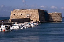
- 4 Iráklion.Particularly worth seeing is the beautiful promenade with the port fortress Koules from the 16th century at the Venetian port, where the Venetian arsenals (warehouses) have also been preserved. For a long time it protected access to one of the most important ports in the Republic of Venice. The 5.5 kilometer long ring of the Venetian fortress walls with the bastions and moats in front of them, which withstood the Turkish siege for 21 years, is lined with green areas and is practically completely preserved.
- 7 Sitía.
 typical tourist coastal town with castle ruins that are well worth seeing.


.jpg/220px-Agia_Galini_-_panoramio_(1).jpg)


- In the south
- 9 Paleochora.is one of the fastest growing tourist resorts in Greece. Because of this geographical location, Paleochora is at the sunniest point on the island of Crete. The harbor is at the southern end of the headland, and there is another landing stage on the eastern shore promenade. The latter jetty was enlarged in 2018. This is where the ferries and ships that transport locals and tourists to Gavdos, Sougia or Agia Roumeli (also the exit of the legendary Samaria Gorge) or to the beach of Elafonisi stop.
- 10 Chóra Sfakíon.Small place that lives mainly from transit and hiking tourists. Some of them are visitors to the Samaria Gorge, who are brought to or from there by ships (via Agia Roumeli). Other well-known gorges nearby are the Imbros Gorge in the east and the Aradena Gorge in the west.
- 11 Agia Galini.Thanks to its picturesque location, Agia Galini developed from a small fishing village into a center of package tourism in the late 1970s and 1980s and since then has numerous hotels, guest houses, taverns, bars and discos as well as a campsite. As in many tourist centers, in Agia Galini you will find a so-called eating alley, in which one tavern is lined up after the other. The harbor square, with its house facades stacked up on the slope, is one of the most beautiful in Crete.
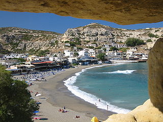
- 12 Matala.The place is known for its beautiful beach and for the caves right on the beach. In the 60s and 70s, Matala was the most famous hippie place in Crete. Today a purely touristy seaside resort.
- 13 Ierápetra.Nice promenade with castle complex. From Ierapetra, tourist boats go to the uninhabited islands of Chrysi and Koufonisi in summer.


Other goals
There is a lot to discover on and around Crete, both in terms of landscape and culture:
Archaeological sites and castles
- The unauthorized possession of archaeological objects and the attempt to export them are subject to heavy penalties. Travelers should definitely not take stones from archaeological sites with them !!
Minoan


In addition to the most important excavations mentioned here, there are many smaller ones, see here
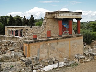
- 1 Knossós (Κνωσός), 5 km south of Iráklion.The Palace of Knossos was created as a building ensemble of up to five floors with a built-up area of 21,000 m². 800 rooms are verifiable, but the palace may have had a total of up to 1,300. The palace was never fortified. Like all Minoan palace complexes, it is built around a rectangular central courtyard. Angled, comparatively narrow corridors, richly decorated corridors, painted halls, elaborately designed stairwells and columned galleries approach this courtyard from four directions. The facility was the administrative center and contained numerous workshops.
- 2 Phaistos (Φαιστός), in the Messara plain (South Crete).The ruins of the palace of Phaistos once formed the second largest Minoan palace in Crete after Knossos, covering an area of 8,400 m². At a distance of about two kilometers northwest of Phaistos there was another, smaller Minoan palace complex (Agia Triada) on a neighboring hill. Both palaces were connected by a paved path. The ancient port of the settlement, Kommos, was about six kilometers southwest of the Palace of Phaistos on the Libyan Sea, north of today's Matala.
- 3 Malia palace (Μάλια).Along with Knossos, Phaistos and Kato Zakros, it is the largest palace complex on Crete. The ancient name of the palace is unknown. The palace area has a diameter of about 600 meters. The total area of the city is estimated to be around 80 hectares. Like Knossos, Malia also had two ports. From the west harbor you can still see an access canal carved into the rock.
- 4 Zakros palace (Ζάκρος Λασιθίου).A bit out of the way and not as impressive as Knossos, but worth a visit if you're interested in Minoan civilization.
.jpg/350px-Festos1(js).jpg)


Classical Greek and Roman


As with the Minoan, the Greco-Roman has a very large number of archaeological sites on Crete, of which only the most important are mentioned here.
- 5 Gortyn (Γόρτυνα).During the Minoan era, this was one of the largest cities in Crete. The city reached its peak during the Roman Empire when the Romans established the capital of Crete and Cyrenaica (now Libya) in Gortys. The city was finally destroyed by the Arabs in 828 AD. The Gortys is one of the most important archaeological sites in Greece. The oldest legal code in Europe (450 BC) was found here.
- 6 Eleftherna (Ελεύθερνα).Ancient ruins from the Minoan-Ancient Greek period in a scenic location. A rare ancient cantilever bridge, the Eleutherna Bridge, has been preserved near the town.
- 7 Itanos (Ίτανος).However, Itanos' heyday as a rich port city was in the classical and Hellenistic epochs of antiquity. In the 3rd and 2nd centuries BC Itanos was allied with Egypt, and also from the year 70 BC. A corresponding contract with Egypt was found. In between, from 140 BC Itanos was allied with Hierapytna (Ierapetra) and together with this city ruler over all of Eastern Crete. Itanos was destroyed by an earthquake in 795 and then rebuilt. In the 15th century the city became deserted after the inhabitants were driven out by pirates.
- 8 Naxos.A worthwhile destination especially because of the wonderful location on Mount Oxa, with a panoramic view of the lagoon of Elounda.
- 9 Aptera (Άπτερα), near Chania above Souda Bay.Aptera has been a settlement point since ancient times. Ruins of different eras: Mycenaeans, Dorians, Hellenes up to the Byzantines, they all left their traces here. Sufficient water, a magnificent view of the Bay of Souda and a strategically important location have always been an important point to settle down.


- 10 Lató (Λατώ).Originally there was a Minoan settlement from around 1500 BC at this point. BC Lato was probably established in the 8th century BC. Founded by the Dorians. The ruins that have been preserved date from the 5th century BC. The foundation walls of the residential houses reveal the earlier structure of the city - the remains of a sanctuary, the agora and a cistern have also been preserved.

Byzantine-Venetian-Ottoman


The economically important location in the maritime trade is also reflected in the large number of castles, of which only the most worth seeing are mentioned here, others here.
- 11 Frangokastello Castle (Φραγκοκάστελλο Χανίων), Southwest crete.The castle is one of the most famous in Greece due to the legend of the Drosoulites. The castle was built as a garrison by the Venetians in 1371-74 to restore order to the rebellious Sfakia region, deter pirates, and protect Venetian nobles and their possessions. In 1770 the Cretan rebel Ioannis Vlachos, also known as Daskaloyiannis, occupied Frangokastello, but was later captured by Turkish forces. He was tortured and executed in Heraklion. On May 17, 1828, a famous battle was fought in Frangokastello. Hundreds of Sfakiots and Epiroten, led by Hatzimichalis Dalianis, a Greek patriot from Epirus who tried to spread the Greek War of Independence from the mainland to Crete, occupied the castle but were besieged and captured by the Turks.
- 12 Gramvousa Castle (Γραμβούσα Χανίων).On the highest part of the island, 137 meters high, the Venetians built an impressive castle between 1579 and 1584 to protect the entire north-eastern Crete.
- 13 Firka Castle (Φρούριο Φιρκά)..On the northwest side of the port of Chania, the Venetians built the Revellino del Porto, a fortified structure to protect the port. Construction began in the mid-16th century and was completed a few years before the Turkish conquest, almost a century later.
- Chania fortress. The first fortifications date from the Hellenistic period. The later Byzantine wall is associated with the reconquest of Crete after the period of Arab rule (824-961) in 961 and the program initiated by the Byzantines to rebuild and fortify key positions in Crete and the Aegean Sea. After the fourth crusade (1204) and the fall of Byzantium, Crete was sold to the Venetians and conquered by the Ottomans in 1645 after a two-month siege.
- 14 Koules Castle (Κούλες).The Koules Castle dominates the modern port of Heraklion. It is a massive two-story fortress that used to guard the entrance to the port. The castle was built by the Venetians in the early 13th century and was called Rocca al Mare. Today she is known under the Turkish name Koules.
- 15 Heraklion fortress (Ενετικά Τείχη Ηρακλείου)..The walls of the city of Heraklion date from the Venetian times of Crete. Its construction began in 1462 and lasted more than a century. This is the best preserved fortress from the 15th-16th centuries. Century and the best preserved fortress in the Mediterranean in general.
- 16 Spinalonga fortress (Φρούριο Σπιναλόγκας).The Venetians had built one of their strongest fortresses on this island. It protects the bay of Elounda, which was important for the Venetian sea trade. In 1715 the Ottoman Turks conquered Spinalonga, took over the last remaining Venetian fortress and removed the last Venetian military presence from the island of Crete. During the Cretan uprising of 1878, only Spinalonga and the fortress of Ierapetra were not taken by the Christian Cretan insurgents. In 1881 the 1112 Ottomans founded their own community and in 1903 the last Turks left the island. The island was later used as a leper colony from 1903 to 1957. It is one of the last active leper colonies in Europe. The last resident, a priest, left the island in 1962.
- 17 Casarma Castle (Σητεία).The fortress known today as "Kazarma" (Casa di Arma) is the most imposing historical monument in Sitia. It was originally a Venetian construction with major changes during the Ottoman period.
- Ierapetra Castle. The Venetians occupied Crete in 1212 and held it until the middle of the 17th century. Ierapetra Castle was built by the Venetians in the 13th century to protect the port and the city. In 1508 it was destroyed by a strong earthquake and not fully repaired. The Ottomans captured Ierapetra in 1647 and renovated the fort. They also built another larger castle in Ierapetra and city walls that were destroyed by the Greek population after the liberation of Crete.
- Rethymno fortress. The Fortezza is the Venetian fortress of Rethymnon, almost in the center of the old town. The castle is visible from every corner of the city and offers panoramic views of Rethymnon and the coast to the west.


Monasteries


Even if you are not Orthodox, a visit to the many monasteries of Crete is worthwhile, as they are often located in a very beautiful, remote landscape. So the way can also be the goal.
- 1 Gonias Monastery (Μονή Οδηγητρίας Κυρίας Γωνιάς Χανίων).Nice and peaceful! € 3 entry, museum shop with beautiful icons, paintings, robes, books and relics. The church itself is very impressive. The gravel bottom is breathtaking with the sea in the background. Worth a visit!
- 2 Arkádi Monastery (Μονή Αρκαδίου Ρεθύμνης).Monastery in the mountains near Réthimnon, national shrine of Crete. The monastery played a prominent role in the Cretan struggle for independence from the Ottoman Empire. From a pretty little one about 1,000 m away 18 chapel there is a fantastic view as far as Réthymnon, a walk from the monastery there is worthwhile.
- 3 Preveli Monastery (Πρέβελη).Worth seeing monastery complex in scenic surroundings.
- 4 Fortified Church of St. George of Falandra (Άγιος Γεώργιος Φαλάνδρας).A fortified church consecrated to St. George with fastening elements. It is located in the parking lot of the Faistos archaeological site on the west side of the hill of the Faistos Palace. The church and ruins are the remains of a monastic fortified complex built during the Venetian occupation in the 16th century. The monastery was destroyed by the Turks in 1821 after the outbreak of the Greek Revolution on the mainland.
- 5 Weir monastery Odigitria (Μονή Οδηγήτριας Ηρακλείου).Odigitria Monastery is located in a remote area on the west side of Mount Asterousia. The complex was protected by a strong fortification, of which some parts of the walls, tower and main gate (with the inscription 1568) remain today.


-Agios_Georgios_church_3.JPG/320px-Agios_Ioannis_(Festos)-Agios_Georgios_church_3.JPG)

- 6 Toplou Monastery (Μονή Τοπλού Λασιθίου).Impressive monastery with beautiful icons inside, good souvenir and wine shop inside. Worthwhile stop during the trip to Vai Vai.

Landscapes

- 1 Chandrás plateau, east of the road from Sitía to Ierápetra. Lots of ruins.
- 2 Lasithi plateau (Οροπεδίο Λασιθίου).A large fertile plateau in the center of Lassithi prefecture at an altitude of 840 meters. Up to 10,000 windmills with white sails used to be in operation on the plateau, but most of them were replaced by diesel and electric irrigation pumps. Along the passes above the plateau there are still numerous old stone windmills (some ruins, others beautifully restored).
- 3 Askifou plateau (Τοπική Κοινότητα Ασκύφου), in western Crete.
- 4 Vai (Φοινικόδασος του Βάι).At Vai in the very east of the island is the only date palm beach on the island. It is believed that pirates used to stop here and leave their remains of dates behind.
- 5 Lake Agios Faraggo. Very impressive salty lake right on the coast, called Vourvoulitis, surrounded by vertical cliffs. The lake is connected to the open sea through an underground passage. If the beautiful view from above is not enough, you can swim to the lake from the sea, but it is quite dangerous as the sides are steep. Vourvoulitis is one of the two most impressive chasms in Crete, which are located on the seashore. A few meters to the east and near the village of Kali Limenes there is another similar chasm called Little Vourvoulitis.


Ravines
There are a variety of gorges. Some are easier to climb, others can only be overcome with a ladder and rope. Good information about the individual gorges here
- 6 Agia Irini Gorge (Φαράγγι της Αγίας Ειρήνης).The gorge is 7.5 kilometers long and 45 to 500 meters deep in a wooded area with steep mountain cliffs. In 1866 1,000 women and children fled from the Ottomans through this gorge.
- 7 Aradena Gorge.it is one of the lesser known, but still one of the most spectacular gorges of the Sfakia in the southwest. The Aradena Gorge has only been accessible for a few years - provided it does not have water - even without climbing routes; the passages through the bottom of the gorge that were formerly only accessible by ladder and rope can now be bypassed by an easily walkable mule track on the western slope of the gorge. The ascent from the sea to Aradena takes about three hours.
- 8 Kotsifou Gorge (Φαράγγι Κοτσυφού).The northern entrance to the gorge is at the village of Kanevos at an altitude of around 450 meters. After a few switchbacks you come to a narrow point where the overhanging rock faces almost seem to touch. Further down, the gorge widens and reveals the bay of Plakias. Left and right, the barren walls of the gorge, over 200 meters high, form an attractive contrast to the green landscape in the north.
- 9 Kourtaliotiko Gorge (Κουρταλιώτικο Φαράγγι).The connecting road leads through the gorge from the district capital Rethymno in northern Crete to the south coast to Plakias and Preveli. It was only paved in the early 1960s and is now one of the most spectacular gorge crossings in Crete. The rock walls on the left and right rise steeply up to 250 meters, with the river bed in places still over 100 meters below street level.
- 10 Myli Gorge (Μύλοι Ρεθύμνης).The valley of the watermills northeast of Rethymno. In the gorge you can see the remains of numerous elaborately built buildings, bridges and canals for water mills, which were built in the 16th century, at the time of the Venetian rule on Crete, and some of which were in operation until the 1970s. It was mainly flour mills that processed the wheat grown in the area. One of the mills has been restored and is open to the public as a museum. The chapels are also worth seeing, especially the old Agia Nikolaos.
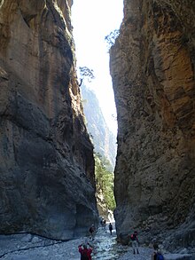
- 11 Samaria Gorge (Φαράγγι της Σαμαριάς).18 km walk through a breathtaking landscape. A highlight of Crete.
- 12 Canyon of the Dead.The steep-walled gorge is about eight kilometers long and can carry water in some places. A hiking trail through the gorge is marked and accessible all year round. The gorge is called "Valley of the Dead" because the Minoans buried their dead in the numerous caves on the side walls. At the end of the gorge is the Minoan palace Kato Zakros.
- 13 Aposelemi Gorge (Aposelémis Potamós)
- 14 Kalikratis Gorge
- 16 Perivolakia Gorge
- 17 Imbros gorge (Φαράγγι Ίμπρου).it is one of the most visited gorges in Crete after the Samaria Gorge. The hiking trail through the gorge is eight kilometers long and leads from the village of Imbros to Komitades on the Libyan Sea. A difference in altitude of around 650 meters is overcome. Especially since the Samaria Gorge became overcrowded, day trips to the Imbros Gorge are increasingly being offered. During the season, the municipality of Sfakia charges an entrance fee for the inspection. The walking time is about two hours. The Imbros Gorge is one of the more easily accessible gorges in Crete, there are no climbing or other problematic passages to overcome. Because of the coarse gravel ground (river bed), sturdy shoes must be worn. The gorge only seems to have water after exceptional rainfall, so it is also possible to visit it in winter.


caves

There are many caves and stalactite caves on Crete, some of the most beautiful are these:
- 18 Sfendoni cave (Σπήλαιο Σφενδόνη Ζωνιανών).The stalactite cave has been developed and is the most beautiful cave in Crete. It is part of the Psiloritis Natural Park.
- 19 Dictate Antron cave (Δικταίο Άντρο).The impressive stalactite cave of Zeus is only a 10-minute walk from the village of Psychro, on the Lassithi Plateau at an altitude of 1025m.
- 20 Idean grotto (Ιδαίο άντρο).The cave is not of particular geological value, but has enormous mythological and cultural value, as it is the cave where, according to legend, the greatest god of ancient times, Zeus, grew up. It is also called the cave of Zeus.

.jpg/350px-Cave_Dikti12(js).jpg)

miscellaneous


.jpg/220px-Chania_(04).jpg)
During World War II, Crete was a hotly contested island, where the Wehrmacht wanted to drive out the English troops. The paratroopers bore the brunt of the attack.
- 1 Maleme German War Cemetery (Γερμανικό στρατιωτικό νεκροταφείο Μάλεμε).Memorial to the fallen soldiers of the conquest of Crete by the Wehrmacht in World War II.
- 2 Souda Bay War Cemetery (Συμμαχικό Νεκροταφείο Σούδας).Most of the Commonwealth soldiers buried here were members of the land forces that died in the airborne battle for Crete in May 1941 during World War II.
- 3 German war memorial of the paratroopers. On the old road to Kissamos and about one kilometer outside the city limits of Chania, the paratrooper memorial stood in its original form from 1941 to 2001. It was built during the German occupation and was dedicated to the 2nd Battalion of the German Airborne Assault Regiment, which was significantly involved in the conquest of Crete in the Chania area with high losses. The eagle on the base of the monument has been missing since winter 2001 due to storm damage. Damage and graffiti on the plinth with calls for reparations are evidence of the political differences that still exist. In Crete, the monument is called To Germaniko Pouli (“the German bird”) - this is also the name of the nearest bus station - or To kako pouli (“the bad bird”).


.jpg/153px-Chania_(04).jpg)
background


geography: Crete is extremely diverse in every respect and deeper exploration takes time if you don't just want to scratch the surface. On the island that is more than twice the size Mallorca is, over 600,000 people live, and it takes a whole day to get from one end to the other, because the 245 kilometers as the crow flies between the west and east coast become 350 kilometers of adventurous coastal road. Geographically speaking, the island is a mountain range, the upper areas of which protrude from the water and the Libyan Sea from the Greek Aegean separate. The highest peaks tower 2456 meters above the sea and with their snow sparkle in the sun until May.
history: In the Bronze Age, Crete was home to the Minoan culture, the earliest advanced civilization in Europe (approx. 2000-1100 BC), which among other things, the sea trade in the entire eastern Mediterranean Sea controlled. Several palace ruins from this period have been excavated and can be visited. The most famous is the Palace of Knossós, in whose labyrinth, according to legend, the Minotaur, half human, half bull, was held captive.
The Minoan was followed by the Mycenaean culture of mainland Greece. The further history of Crete is shaped by numerous attempts at conquest by various peoples. In 69 BC. Crete fell to the Romans, followed by the Byzantines. In the 9th and 10th centuries AD. Muslim pirates ruled the island. At that time, Gortyn, one of the largest cities, was destroyed and the new capital Heraklion founded. Byzantium recaptured the island and later it fell to Venice. The Cretans consistently defended themselves against the Venetians, who considered the island their property from 1204 to 1645. Then came the Turks who conquered Crete between 1645 and 1669. Again and again the islanders rose up against this and were finally able to end Turkish rule in 1898. The last time the Cretans fought as partisans in World War II and defended the island against the German Wehrmacht, which came to the island on May 20, 1941 and stayed until October 1944.
When the Turks left Crete in 1898, many Turkish structures were razed to the ground. Only in the 1980s, when the importance for tourism became clear, did the restoration of the remaining mosques begin.
During the Second World War (May 20 to June 1, 1941), German paratroopers landed, supported by mountain troops, to conquer the island of Crete. Shortly after the capture of Greece in the Balkan campaign in 1941, the German Wehrmacht conquered Crete, which was defended by Commonwealth and Greek troops, and then occupied the western part of the island until the end of the war in 1945.
In 1974 Turkish troops attacked Cyprus, and everyone expected a war between the two nations. At that time, many Cretans took out their rifles of their own accord and looked for Turkish ships on the coast.
Cretan identity: Orthodoxy is an important part of Cretan identity, as it was the solid rock that gave the islanders their national consciousness, their own language and tradition during all the years of war and suppression. Another part is the almost hostile attitude towards the Turks. Another expression of Cretan identity is the feeling of being a special Greek as a Cretan. The island is richer than many other regions in the country, and Crete's culture is older than that of the rest of the country Greece and Europe.
language
In Crete, as one might expect, Greek is spoken. Anyone who does not speak this language and is therefore dependent on translations with Latin letters is faced with the problem that there is no uniform spelling with Latin letters for Greek words. Therefore, one encounters different spellings of the same name in each case, and then the correct pronunciation is even more difficult. Good travel guides write the names in such a way that the stress of a word is always on the syllable marked by an accent. For example, Chaniá the last a stressed.
See also: Phrasebook Greek.
getting there
The Crete traveler can choose whether he wants to reach the island in three hours by plane or three days for a ferry crossing Italy Takes time.
By plane
In the summer months, charter flights connect almost every German-speaking airport with the island's capital Iráklion. From some airports it is also possible to go straight to Chaniá to fly. over Athens you can reach both the old and the new island capital several times a day, Sitía several times a week. Domestic flight connections of course also exist and run from Mykonos, Rhodes, Santorin and Thessaloniki to Iráklion, of Thessaloniki to Chaniá and from Karpathos to Sitía.
Airports in Crete:
- 1 Heraklion Airport "Nikos Kazantzakis" (Κρατικός Αερολιμένας Ηρακλείου «Νίκος Καζαντζάκης», IATA: HER)
- 2 Chania Airport "Ioannis Daskalogiannis" (Διεθνής Αερολιμένας Χανίων «Ιωάννης Δασκαλογιάννης», IATA: CHQ)
- 3 Sitia airport (Αεροδρόμιο Σητείας, IATA: JSH)


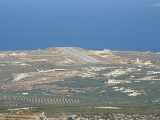
In addition, the construction of a new airport at Kastelli, about 36 kilometers southeast of Heraklion, planned. Dieser soll den „Nikos Kazantzakis“-Flughafen in der Zukunft ersetzen. Die Grundsteinlegung erfolgte am 08.02.2020, die Inbetriebnahme soll voraussichtlich 2025 erfolgen. [1]
Links zu Fluggesellschaften, die Kreta das ganze Jahr über anfliegen:
By boat
- Autofähren verkehren ganzjährig täglich zwischen Piräus und den kretischen Häfen Chaniá, Réthymnon and Iráklion, mehrmals wöchentlich zwischen Piräus, Ágios Nikólaos and Sitía. Für Reisende mit viel Zeit besteht die Möglichkeit, einmal pro Woche mit einer Autofähre, die unterwegs zahlreiche Häfen anläuft und daher sozusagen den "Bummelzug" durch das Mittelmeer darstellt, nach Kíssamos-Kastélli zu gelangen.
- Links zu den Fährgesellschaften:
- Für Sportboote bieten sich an der gesamten Küste der Insel viele Anlegemöglichkeiten nicht nur in den offiziellen Häfen sondern auch in unzähligen Buchten.
mobility
Ideales Fortbewegungsmittel für den Urlauber auf Kreta sind das Auto oder das Motorrad, denn nur mit deren Hilfe ist es möglich, die Insel bequem und vollständig zu erkunden.Die Straßenverhältnisse schwanken zwar stark, sind mit jeweils angepasster Geschwindigkeit aber gut befahrbar. Allerdings sollte man immer ein Auge auf plötzlich auftauchende Schlaglöcher bzw. Schaf- und Ziegenherden haben. In Kurven muss man mit schlechter Reifenhaftung rechnen, durch Sand, Staub und das besonders auf nassen Straßen. Die Straßen in Kreta sind nicht für schnelles fahren geeignet. Besonders problematisch sind Roller mit kleinen Reifen. Wer diese nicht gewöhnt ist, sollte immer Mopeds mit großen Rädern nehmen.
Die Kreter selbst fahren eher Freistil und schneiden gerne Kurven, weshalb vor jeder unübersichtlichen Abbiegung Hupen und äußerstes Rechtsfahren empfehlenswert ist. Autovermietungen gibt es in praktisch jedem Urlaubsort, so dass ein Mietwagen kein Problem darstellt. Als zuverlässig hat sich die Vermietung Greenways erwiesen, die über Büros fast überall auf der Insel verfügt. Ein Jeep ist nicht unbedingt notwendig, auch wenn der Vermieter etwas anderes behauptet. Ganz anders sieht es bei der Straßenkarte aus, die im Maßstab 1:200 000 vorliegen sollte. Die Straßenschilder sind fast alle sowohl in griechischen als auch in lateinischen Buchstaben beschriftet, so dass die Orientierung wesentlich erleichtert wird.Navigationsgeräte sind recht hilfreich, man sollte jedoch bereits im Heimatland immer auf die aktuellsten Kartendaten updaten und sich auch dann nicht zu 100% darauf verlassen.
Der EU-Führerschein ist Pflicht, eine grüne Versicherungskarte ist nur beim Fahren des eigenen Autos empfehlenswert. Tankstellen gibt es in ausreichender Zahl, und die vielen kleineren KFZ-Werkstätten verstehen sich ausgezeichnet auf Improvisation. Parkplätze hingegen sind selten.
Wer nicht selbst fahren möchte, der lässt sich per Linienbus kutschieren. Das Netz der öffentlichen Verkehrsmittel ist recht dicht, und so gut wie alle Städte sind direkt mit der Hauptstadt Iráklion connected. Die Busse fahren regelmäßig, Fahrpläne hängen auch in lateinischer Schrift aus. Fahrkarten kauft man entweder an den Busbahnhöfen oder unterwegs beim Fahrer.
Tipps
- Car rental companies: Leider gibt es speziell in touristischen Orten doch immer wieder "Schlitzohren". Achten Sie speziell auf einen aktuellen Vertrag, der auch die AGB zumindest in englischer Sprache enthält, begutachten Sie das KFZ genau und lassen Sie sich alles erklären. Wenn die lokale Autovermietung nicht vertrauenswürdig erscheint, mieten Sie das KFZ bei renommierten Vertretungen.
- Motorradfahren: Wie erwähnt sind die Straßen zum größten Teil durchaus gut ausgebaut. Dennoch stellt das Fahren mit dem Motorrad auf Kreta eine Herausforderung dar und man sollte doch bereits einige Erfahrung mitbringen. Oft können die Straßen in Küstennähe aufgrund der Luftfeuchtigkeit und des verdunsteten Meersalzes extrem rutschig werden. In Gebirgsregionen kommt es immer wieder zu Steinschlag (ganzjährig!) und bei weniger gewarteten Straßenabschnitten kann es durchaus vorkommen, dass ein Stück Straße weggerutscht ist. Fahren Sie speziell mit dem Motorrad immer vorausschauend und auf Sicherheit! Achten Sie bei der Einreise auf den verkehrstechnisch einwandfreien Zustand Ihres Motorrades! Ersatzteile - speziell für ausgefallene Motorradmarken - sind auf Kreta kaum vorrätig und müssen im Notfall über Athen angefordert oder sogar aus dem Heimatland eingeflogen werden. Wenn man als Motorradfahrer eine Schafs-Ziegenherde auf der Straße sieht, ist es ratsam nicht zu versuchen zwischen den Tieren durchzufahren, da die Hütehunde oft sehr aggressiv sind. Besser in sicherer Entfernung warten, bis die Tiere von der Straße sind. Zwar werden die Hunde auch dann angreifen, aber man kann zumindest schnell weiterfahren.
Practical advice
Bargeldloses Bezahlen ist zwar besonders in den Touristenhochburgen weit verbreitet, viele Kreter bevorzugen aber Bares. Die Gründe dafür sind mannigfaltig, zu ihnen gehören auch die häufig unzuverlässigen Internetverbindungen, die dazu führen, dass Kartenzahlungen viel Zeit brauchen oder wiederholt gänzlich abgebrochen werden. Man sollte sich daher nicht zu sehr auf die Bankomatkarte verlassen.
ATMs findet man eigentlich fast überall, in ländlichen Regionen sind sie aber oft weit voneinander entfernt. Besonders außerhalb der Saison sind die Geräte manchmal außer Betrieb. Es empfiehlt sich daher, sich mit Euro zu versorgen, bevor es dringend wird. Viele griechische Banken erheben zusätzlich zur von der Heimatbank in Rechnung gestellten Gebühren um die drei Euro, auch wenn die Heimatbank mit „kostenlosem Geldabheben in der Eurozone“ wirbt. Eine der wenigen Banken, die diese Zusatzgebühren nicht abzieht, ist die Genossenschaftsbank Pancreta Bank (Stand: 4/2019), die auch über eine Geldautomatensuche online verfügt.
activities
beaches

Gute Strände sind ein Hauptgrund, dass so viele Gäste nach Kreta kommen. Ihre Zahl ist bei der Größe der Insel sehr hoch. A Strandführer erleichtert die Auswahl. Also FKK-Strände findet man in großer Zahl.
hike

Kreta ist ein ideales Wandergebiet. Für Wanderer der Hinweis auf den europäischen Fernwanderweg Nr. 4.
Wer gut zu Fuß ist, der sollte bei Gelegenheit eine Wanderung durch die als Nationalpark geschützte Samariá-Schlucht machen. Dies ist allerdings nicht ganzjährig möglich: Von November bis April ist das Betreten der Schlucht aus Sicherheitsgründen behördlich untersagt. Die Wanderung umfasst eine Wegstrecke von immerhin 14 Kilometern (also ca. 4-5 Stunden) und beginnt in 1.250 Metern Höhe an der Omalós-Hochebene bei Xilóskalo. Während des Wanderns lassen sich zunächst die mit Wäldern dicht bewachsenen Berge bewundern, später folgen steile Felswände zu beiden Seiten des Pfades. Nach dem ersten Wegdrittel bietet sich eine Rastmöglichkeit im verlassenen Dorf Samariá an, wo eine Quelle zum Auffüllen des Wasservorrats genutzt werden kann. Beeindruckend wirkt die Passage an der Eisernen Pforte, wo der Weg nur noch drei Meter breit ist, die Wände jedoch 350 Meter hoch zu beiden Seiten sehr steil ansteigen. Endpunkt der Wanderung ist Agía Rouméli.
Nicht ganz so lang ist eine Wanderung durch die Imbros-Schlucht. Man beginnt im Dorf Imbros an einer Taverne. Dort ist auch der Eingang ausgeschildert und ein paar Parkplätze gibt es auch. Nach ca. 1 km kommt man zum Schluchteingang, wo man erstmal 2,50 Euro p.P. (Stand: Mai 2019) Schluchtgebühr bezahlen muss. Die Wanderung bis zum Schluchtausgang ist ca. 8 km lang und führt meist über ziemlich steinige Wege. Ab und an trifft man auf ein paar Ziegen. In der Mitte der Schlucht befindet sich eine kleine Hütte, an der erstaunlicherweise die Tickets kontrolliert und abgestempelt werden.Am Schluchtausgang gibt es dann auch eine kleine Bar und zwei taxi-Stops, d.h. man kann sich gegen ca. 10€ Gebühr zu seinem Auto nach Imbros zurückfahren lassen. Typischerweise ist dem Durchschnittswanderer dieser Preis im Angesicht des schluchtaufwärtigen Rückwegs herzlich egal. :-)
Durch die noch unbekannte Schlucht „Agia Irini“ im schönen ursprünglichen Westen Kretas (nur 8 km lang) kann man das ganze Jahr über wandern. Diese Wanderung ist auch für Familien mit Kindern geeignet. Es ist eine leichte Wanderung, die man auch im Hochsommer gut machen kann.
Bootstouren
Die Bootstour zur Lagune Balos (Westkreta) mit türkisblauem Wasser ist für Kinder und Erwachsene ein Erlebnis. Diese Tour beginnt von Kastelli aus mit dem Boot „Gramvousa Express“.
Eine weitere Tour ist die von Kolimbari (Westkreta) vom kleinen Hafen aus zur Spitze der Gramvousa - Halbinsel zum Venezianischen Kastell.
Ein sehr schönes Ausflugsziel ist auch von Chora Sfakion (oder Sfakia im Südwesten Kretas) mit dem Boot oder öffentlichen Fähre zum autofreien Ort an der Südküste nach „Loutro“.
Ein Tagesausflug mit der Fähre "Samaria I" von Paleochora (Südwestkreta) zur kleinen Insel „Gavdos“ ist auch für Kinder sehr spannend, ganz besonders wenn man das Glück hat, unterwegs Delphinen zu begegnen. Wenn man jedoch auf der Insel bleiben will, muss man mindestens einmal übernachten, da das einzige Schiff des Tages direkt nach der Hinfahrt wieder zurückfährt. Dann kann man jedoch auch schön 4 km von einem Ort, den man per Bus/Taxi erreicht zum Kap Tripiti wandern, dem südlichsten Punkt Europas.
Of Plakias (Südwestküste) mit dem Boot zur Prevelli-Schlucht: Das ist eine palmenumsäumte Schlucht, mit Wasserläufen, die man auch mit Kindern gut durchwandern kann.
Of Ierapetra (Südostkreta) kann man Bootstouren machen zur vorgelagerten Insel „Chrissi Island“.
sailing
Unter deutschen Pauschal-Urlaubern erfreut sich Kreta seit Jahrzehnten großer Beliebtheit, nur unter Yachties ist die größte Insel Griechenlands im Süden der Ägäis meist kein großes Thema. Grund dafür sind vor allem die hohen Berge, die Kreta von West nach Ost durchziehen. Von ihnen stürzt im Sommer der Meltemi an vielen Stellen in Sturmstärke herab. Dieses lokale Wetter Phänomen ist eingebettet in die Großwetterlage, die gerade in den heißen Monaten (April bis Oktober) über den Küstengebieten Nordafrikas extrem viel warme Luft aufsteigen lässt und diese Fallwinde begünstigt. Für Segler wird das Revier vor allem an der Südküste bei diesen Starkwinden mit 4-6 Beaufort, in Böen auch Sturmstärke mit 9-10 Beaufort, unberechenbar und unbefahrbar. Das ist für den Langtörn-Fahrer, der an den passenden Stellen gut abwettern kann, kein Problem. Für Charter Crews mit den immer gleichen wochenweise Buchungen und Flugrhythmen bei An- und Abreise ist das zu riskant. So war es dann auch nicht überraschend, dass wir für unsere Törnplanung keine passenden Charter Angebote fanden. Vor Ort und tageweise kann man die passenden Yachten problemlos mieten, nur Yacht-Charter ist leider Fehlanzeige.
Wohl auch deshalb erkundete YACHT-Leser Peter Osenberg das Revier daher vornehmlich in der Nebensaison. Er segelte fast komplett um die Insel und fand ein sehr ursprüngliches Greece vor. Kaum andere Crews sind vor Ort unterwegs, abseits der Touristenorte gibt es wunderschöne Ankerplätze und mehr gute Häfen, als man zunächst beim Blick auf die Karte vermutet. Aber auch die angedeuteten Fallböen überfielen die Crew das eine oder andere Mal.
☃↵Quelle: Die ausführliche Törn-Geschichte ist in der YACHT Nr. 9/2018 veröffentlicht, plus Anmerkungen des Autors.
kitchen
See also: Essen und Trinken in Griechenland
General: Wer noch nie in südlichen Ländern war und meint, er wisse, wie Tomaten oder Gurken schmecken, der irrt. Als Reisender am Mediterranean Sea sollte man unbedingt die landestypischen Früchte und Gemüsesorten probieren, wenngleich auf die Gefahr hin, dass man, kaum wieder zu Hause, diese aus dem westlichen Teil Europe gar nicht mehr kaufen mag. Kreta ist allerdings kein Reiseziel für selbsternannte Feinschmecker, denn die regionaltypische Küche soll vorwiegend sättigen und ist entsprechend einfach. Griechen mögen das Essen am liebsten lauwarm und so bekommt man es dann auch in den Tavernen vorgesetzt. Allerdings bieten manche Hotels und Touristenlokale die Option auf ein wirklich heißes Gericht, das extra auf mitteleuropäische Temperatur gebracht wird. Die wenigen ausländischen, vorwiegend italienischen Restaurants halten generell nur heiße Gerichte bereit.
breakfast: Sieht man von den Büfetts in einigen guten Hotels ab, so ist von einem "vorgefertigten" Frühstück eher abzuraten. Statt dessen sollte man nur die Übernachtung buchen und das Frühstück in Kafenía oder Restaurants einnehmen, wo man sich das Essen nach eigener Vorliebe zusammenstellen kann.
Hauptmahlzeiten: Auch für den großen Hunger findet sich auf Kreta praktisch immer eine Taverne. Normale Restaurants sind einfach eingerichtet, aber es gibt auch teurere Varianten und natürlich die Hotels. Die meisten Gerichte kennt der Urlauber bereits vom "Griechen" in der Heimatstadt, wie etwa überbackene Auberginen, griechischen Salat oder (selten) Gyros. Experimentierfreudige Reisende kommen ebenfalls auf ihre Kosten und probieren z.B. kokorédsi (in Darm gewickelte und am Spieß gegrillte Innereien).
Der Ablauf: Die Bestellung an sich sollte unproblematisch sein. Fast immer liegen Speisekarten aus, die zumeist sowohl in Englisch als auch in Griechisch verfasst sind und so auch Nicht-Griechen die Auswahl erleichtern. Die Rechnung enthält immer Mehrwertsteuer und Bedienung, dennoch sind 10 % Trinkgeld üblich.
Wohin zum Essen?: Verbreitet finden sich Restaurants (Estiatório) und Tavernen (Tavérna), die prinzipiell alle Arten von Speisen bieten. Daneben gibt es bescheidene Lokale (Inomajiríon), die Wein vom Fass ausschenken und einfache Speisen in kleiner Auswahl bieten, Kaffeehäuser (Kafenía), die alle Arten von Getränken offerieren, Schnellrestaurants (Pizzería), die in Folie verpackte Pizza im Mikrowellenherd erhitzen, auf Fischgerichte spezialisierte Restaurants (Psárotavérna) und Konditoreien (Sácharoplastíon), die Gebäck, Kaffee und Kuchen bereithalten.
beverages: Nationalgetränk ist eisgekühltes Leitungswasser, das man in den Städten problemlos trinken kann. Bestellt man Kaffee, muss man sich zwischen Instant- und griechischem Kaffee entscheiden. Wählt man Letzteres, so muss bei der Bestellung der gewünschte Süße- und Stärkegrad angegeben werden. Immer richtig liegt man, wenn man den griechischen Kaffee "métrio" = "mittelsüß und mittelstark" wählt. Den Instantkaffee gibt es auch kalt als sogenannten "Frapé" - auch hier sollten man den Süßegrad bei der Bestellung angeben und ob man ihn mit oder ohne Milch haben möchte. Tee kommt hingegen aus profanen Teebeuteln.Erfrischungsgetränke erhält man überall und das besonders in Deutschland so beliebte Bier ist auch auf Kreta verbreitet. So haben mehrere Brauereien Zweigstellen auf der Insel, unter anderem Löwenbräu, Henninger und Amstel. Zu empfehlen ist auch das griechische "Mythos", hergestellt in Regie des Weinvertriebs "Boutári". In den Städten und Touristenzentren erhält man sogar Bier vom Fass.Wein wird auf Kreta grundsätzlich nur zum Essen getrunken. Wenn man schon einmal vor Ort ist, sollte man die auf der Insel angebauten Weine wie Láto or Minós probieren.Als Spirituose ist der Oúzo bekannt, kretischer Nationalschnaps ist der Ráki (aus Weintrester), nicht zu verwechseln mit dem türkischen Raki, der ein Anisschaps ist und deshalb eher dem Oúzo ähnelt.
public holidays
Offizielle Anlässe: Nationale Feiertage auf Kreta sind der 25. März, der 28. Oktober und der 9. November, wo jeweils in den Städten prachtvolle Paraden stattfinden. Ansonsten werden hauptsächlich in den Sommermonaten in vielen Orten der Insel traditionelle und kulturelle Feiern organisiert, die unter anderem über Plakate angekündigt werden. Weitere Feiertage sind:
- January 1st - Neujahrstag
- 6. Januar - Epifánia = Erscheinungstag (Heilige Drei Könige)
- 7. Januar - Fest für Johannes den Täufer
- 23. Februar - Katharí Devthéra
- Easter Sunday - der orthodoxe Ostertermin variiert teilweise stark mit denen in DACH
- 15. August - Mariä Himmelfahrt
- 25. & 26. Dezember - Weihnachten
Das wird außerdem gefeiert:
- Rosenmontag: Dieser Tag wird überall auf Kreta mit Kostümen und Karnevalsumzügen gefeiert.
- Internationales Festival von Kreta: Jedes Jahr treffen sich Ende Mai in Chaniá griechische und ausländische Tanz- und Folkloregruppen.
- Renaissance-Festival: Im Juli findet in Réthymnon dieses überaus sehenswerte Festival statt.
Nachtleben: Je nachdem, in welcher Stadt man sich gerade auf Kreta befindet, sehen die Möglichkeiten für Nachtschwärmer recht unterschiedlich aus. Während in den größeren Städten durchaus der eine oder andere Diskotempel zu finden ist (insbesondere in Iráklion), zieht es besonders die Jugend am Abend in die diversen Tavernen und Lokale, wo aktuelle Pop-Musik läuft.
- Ágios Nikólaos. Hier finden sich einige junge Kneipen und schicke Szeneläden. Am Tag sitzt man am besten in Hafennähe und abends geht man als Publiebhaber in den "Aquarius Pub". Hier findet man gepflegte (westliche) Musik (durchaus erholsam nach der überallorts üblichen griechischen Musik) und sechs(!) großformatige Plasma/ LCD-Fernsehapparate mit vornehmlich englischen aktuellen Sport-Live-Übertragungen. Highly Recommended. Die Preise sind durch gute englische Kundschaft eher gehoben. Nähe Hafen ca. 2 Minuten Laufweg.
accommodation
Auf Kreta wurden im Jahr 2010 rund 16.420.477 Übernachtungen gezählt. Im Jahr 2011 entfielen 1,8 % aller Reisebuchungen für europäische Inseln auf Kreta.[2]
Prinzipiell wird dem Urlauber auf der griechischen Insel eine breite Palette an Unterkunftsarten angeboten. Neben den großen Hotels gibt es fast überall auch Privatzimmer zu mieten. Außerdem gibt es mehrere Campingplätze auf Kreta. Es gibt sogar ein FKK-Hotel in Kreta, was sonst in Griechenland sehr selten ist.
climate
Kreta kommt zu Gute, dass die Insel sehr weit südlich im Mediterranean Sea lies. Mit über 300 Sonnentagen im Jahr weist sie mit Cyprus die höchste Sonneneinstrahlung auf. Der Sommer ist auf Kreta heiß und trocken, wobei insbesondere an der Südküste sehr hohe Temperaturen erzielt werden. Die Winterzeit fällt in der Regel recht milde aus mit viel Regen auf den Hochebenen und Schnee in den Bergen.
Auf Kreta gibt es verschiedene Klimazonen, die sehr unterschiedliches Urlaubswetter bringen können. Dies zu wissen, ist aber auch eine Chance, je nach Jahreszeit den passenden Urlaubsort auf Kreta aus- und aufzusuchen, bzw. noch innerhalb des Urlaubs zu wechseln oder zumindest Ausflüge in eine andere Klimazone zu machen.Grob unterteilt scheidet sich das Wetter auf Kreta in Nord und Süd, bedingt durch die west-östlich verlaufende Gebirgskette. Im Norden hat die europäische Wetterlage größeren Einfluss auf die Temperaturen. Die Folge ist, dass es dort mehr regnet und ca. 3-6 Grad Celsius kälter ist, als im Süden, der von warmen Winden aus Afrika verwöhnt wird.Dazwischen liegen in beiden Zonen viele Mikroklimata, entstanden durch geschützte Bucht- und/ oder Wind abgewandte Lagen.
Die Durchschnittswerte aus Iráklion:
| Iráklion | Jan | Feb | March | Apr | May | Jun | Jul | Aug | Sep | Oct | Nov | Dec | ||
|---|---|---|---|---|---|---|---|---|---|---|---|---|---|---|
| Mean highest air temperature in ° C | 16 | 16 | 17 | 20 | 24 | 28 | 29 | 29 | 27 | 24 | 21 | 17 | O | 22.3 |
| Average air temperature in ° C | 12 | 13 | 14 | 17 | 24 | 24 | 26 | 26 | 24 | 20 | 17 | 14 | O | 19.3 |
| Mittlere Wassertemperatur in °C | 16 | 15 | 16 | 17 | 19 | 22 | 24 | 25 | 24 | 23 | 20 | 17 | O | 19.8 |
| Rainy days in the month | 14 | 11 | 8 | 6 | 3 | 1 | 0 | 0 | 2 | 6 | 8 | 9 | Σ | 68 |
trips
- Hat man auf dem Festland so gut wie alles gesehen, empfehlen sich die vielerorts angebotenen Bootstouren. So kann man einen Ausflug von Réthymnon to Balí unternehmen oder mit einem Linienschiff von Ágios Nikólaos to Sitía fahren und später mit dem Bus zurück.
- An der Südküste bietet sich ein Schiffsausflug von Paleochóra above Soúgia, Agía Rouméli and Loutró to Chóra Sfakíon an, wo man allerdings entweder übernachten oder mit dem Bus weiter nach Chaniá fahren muss.
- Man kann außerdem zu den kretischen Inseln übersetzen. So erreicht man 19 Gávdos of Paleochóra and Chóra Sfakíon aus , die Inseln 20 Chrissí and 21 Koufoníssi (wo zum Beispiel ein Amphitheater zu bewundern ist) werden von den Städten Ierápetra or. Makrigialós mit Schiffen zugänglich gemacht. Jedoch ist zu beachten, das die Fährfahrpläne insbesondere im Winter sehr dünn sein können.


- Schließlich sollte man die Gelegenheit nutzen und einen Tagesausflug zur Vulkaninsel Santorín unternehmen, die je nach Abfahrtsort und Schiffstyp zwischen zwei und vier Stunden von Kreta entfernt liegt.
literature
Web links
- Video über Kreta
- Kreta-Klaus: Seite eines Kreta-Liebhabers und -Kenners mit online Reiseführer der Insel und vielen Insider-Tipps
- Kreta Reiseguru Reiseführer mit Informationen zu den verschiedenen Regionen und Orten der griechischen Insel Kreta
- Kreta Reiseinfos Reiseinformationen zu der Insel Kreta
- Kreta Reisen und Informationen Kreta Reiseportal mit Reiseberichten und Angeboten
- Kreta Reise und Urlaub Online Reiseführer für den Urlaub auf Kreta
- Nudism Führer Kreta und Griechenland
- Reiseportal
Individual evidence
- ↑Kreta erhält neuen Großflughafen www.aero.de, abgerufen am 02.05.2020.
- ↑Wo Herr und Frau Österreicher Urlaub machen www.kreta-urlaub.at (Memento vom 7. März 2015 im Internet Archive)