
The Alpstein massif belongs to the foothills of the Alps and is a well-known hiking area in the Eastern Switzerland, it is mainly in the canton Appenzell Innerrhoden and borders on the cantons Appenzell Ausserrhoden and St. Gallen.
background
The Alpstein rises in the south of the two Appenzell half-cantons. The mountain range belongs to the eastern pre-Alps. Even if the Säntis is the highest point at 2502 m above sea level. is not excessively high compared to other alpine peaks, the massif looks extremely imposing due to the small distance to the lowlands and Lake Constance.
The hiking area, well-developed with cable cars and hiking trails, which is usually in the sunshine above the sea of fog in the autumn months, is a popular hiking region in Eastern Switzerland. It is suitable for day trips, multi-day touring weeks and also for simple excursions with the cable car directly to mountain peaks, also for people with disabilities or those with disabilities. elderly people.
history
At the end of the nineteenth century, interest in the Säntis as a mountain for excursions became more and more popular with guests from southern Germany, which is why a rail link was considered. The Appenzell Railway was connected to the SBB network from Gossau to Appenzell. From the planned "Säntis Railway" with adhesion and then cogwheel operation over the Meglisalp from the south to the Säntis summit, only the lowest stage to Wasserauen could be completed. The summit was later reached by cable car from the Urnaesch resp. developed from Schwägalp.
Typical of the Alpstein region are the numerous mountain inns, which often provided farmers in the mountain region with an opportunity for a sideline - so you can travel comfortably in the Alpstein without heavy luggage.
Landscape / geology

The mountain massif essentially consists of three mountain ranges, which extend from southwest to northeast, the northern and middle is through the Lisengrat connected - from the air you can see the mountains in the shape of a sloping E. imagine with extended legs. Pass crossings allow the mountain ranges to be crossed.
There are various mountain lakes in the valleys, of which the Fählensee and the Säntisersee There is no direct runoff between the two southern chains, they drain underground into the St. Gallen Rhine Valley, as was demonstrated with the help of water staining. From the Seealpsee the Schwendebach runs in the direction of Water meadows and Appenzell.
The limestone mountains are interspersed with fractures, karst caves, underground watercourses, which emerge as springs. They form bizarre rock formations, in between are again picturesque valley floors, which are used as alpine pastures. Numerous aerial ropeways and transport ropeways used for agriculture open up the Alps.
Flora and fauna
Above the tree line, in the Alpstein there is practically only fir forest, there is a diverse flora of alpine flowers in the alpine meadows.
The best-known representatives of the animal world in the Alpstein are the ibex, of which a larger colony can be found at the Listengrat resp. Rotsteinpass takes place; marmots can also be found in many places.
climate
The Central European climate is characterized by a lot of precipitation and cool summers. In the foothills of the Alps, the clouds tend to accumulate in north-westerly / westerly winds, which leads to rain showers and, when suddenly cooling, thunderstorms when in Weather report If there is talk of occasional precipitation in the foothills of the Alps, it is worthwhile to pack a rain cover in your backpack.
From the end of October to April / May, snow is to be expected in the high areas.
getting there

By plane
The nearest international airport is that of 1 Zurich-Kloten Airport, in the 2 Altenrhein Airport Only business and a few international charter flights are handled.
By train / bus
When traveling by public transport, it is almost impossible to avoid using the Appenzellerbahn - rail enthusiasts will miss the colorful variety of the private railways in the Appenzellerland merged in the 1990s, the red and white trains transport travelers with great reliability and a relatively tight schedule.
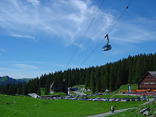
The journey to the SäntisTo start tours from there, take the Appenzeller Bahn to 3 Urnäsch AB , and from there it goes by post bus to the 4 Schwägalp, where the valley station of the cable car is on the Säntis is located.
To start tours in the northern and central Alpstein range, take the Appenzell Railway above 5 Appenzell AB to the terminus 6 Wasserauen AB. If you don't like to get up on foot, you can take the 7 Wasserauen - Ebenalp cable car comfortably reach the Ebenalp.
To get there for tours in the southern Alpstein chain, to the Sämtiser and Fälensee you have to go to 8 Weissbad AB on the post bus line Brülisau change. The 9 Hoher Kasten aerial cableway transport you comfortably on the high box that 10 Alp Sigel-Bahn is suitable for tours in the middle chain.
In the street
For approaching from the motorway ![]() from the west you take them
from the west you take them ![]() Gossau and drives over Herisau - Urnaesch, coming from the east, the route via is recommended
Gossau and drives over Herisau - Urnaesch, coming from the east, the route via is recommended ![]() St.Gallen - Kreuzbleiche - Depth - Appenzell.
St.Gallen - Kreuzbleiche - Depth - Appenzell.
To arrive via Schwägalp, drive in the direction Urnaesch further, to arrive from the east, drive on the bypass road in the direction of Appenzell Brülisau - Weissbad further in Steinegg (at the stop of the Appenzellerbahn) is the junction after Brülisau to High box train marked with a brown signpost, another brown signpost points to the valley station of the mountain railway to the Ebenalp bei Water meadows down.
Alternatively, the Säntis region can also be reached from Toggenburg from over Wildhaus to reach.
mobility


In the hiking area, of course, you mostly move on shoemaker's pony, older or disabled travelers can take the mountain railways up and find, for example, on the Kronberg the opportunity to admire the great panoramic view from a short summit circular path from viewing platforms.
The Alpstein has become very popular with paragliders in recent years.
Skiing is only possible with restrictions in the area, there are ski lifts at Gonten, Appenzell, on the Ebenalp and in BrülisauDue to the hilly and rocky terrain and the only moderate height, there are no large connected ski areas. The Alpstein is a popular ski touring area, which is a treat for experienced ski tourers Säntis run: the most traveled route leads over the large snow and the Mesmerchämi down to Wasserauen. In early summer you start on the Säntis in high winter conditions and carry your skis through a spring landscape to the train station.
The unprepared or marked Säntis run is only reserved for experienced skiers (ideally under an experienced guide), depending on the weather and avalanche situation (inquire with Old Säntis, see website, the departures will be blocked. If necessary, information from SAC - Swiss Alpine Club catch up.
Most famous tour destinations
Säntis
The 1 Säntis forms with its height of 2502 m above sea level. M. the highest point of the Alpstein massif. Due to its exposed location, the Säntis Visible from afar and offers a unique panoramic view of six countries: Switzerland, Germany, Austria and Liechtenstein, with good visibility even as far as the French and Italian Alps.
From the Säntis you can use the 1 Lisengrat Continue in a southerly direction to the other Alpstein chains (surefootedness is a prerequisite!), to the east you can go over the Ladder to heaven to the Öhrli, Schäfler to Ebenalp you can get to the west via the Sheep floor and Gamplut to Wildhaus descend. Another way is via the 1 Animal meadow (here mountain inn) down to Schwägalp.
Accommodation Catering
- 2 Säntis summit panorama restaurant. Tel.: 41 (0)71 365 65 00, Email: [email protected]. Modern panorama restaurant at the mountain station of the Säntisbahn, you can walk to the summit with the old weather station.
- 1 Mountain inn Alter Säntis. Tel.: 41 71 799 11 60, Email: [email protected]. Restaurant, guest room and mattress dorm.
in the northern Alpstein chain, from the east
Ebenalp

The 2 Ebenalp at 1644 m above sea level can be reached comfortably in six minutes with the aerial cableway Wasserauen-Ebenalp, it is a starting point for tours, especially on the northern chain of the Alpstein massif. If you like, you can also walk from Schwende from over Ponderous or from Water meadows from over the Schwendebachtal, over Dürschrennen, past the Berggasthaus Äscher and through the Wildkirchlihöhe.
Past the 2 Chluus, in the alpine hut you can stop off in the summer months, you get to the Schäfler.
The short walk down to the Ebenalp is worthwhile Wildkirchlihöhle. You walk through this tunnel-like cave on the hiking trail and arrive at the Bärenhöhle, the first of the Wildkirchlihöhlen; traces of cave bears and cavemen from the Neanderthal era around 50,000 - 30,000 BC were found here in 1904. Found. Hermits lived in the middle cave from 1658, the cave became a Altar cave converted into a church service room and in 1972 a hermitage was rebuilt. In the third cave directly on the rock face has stood since the end of the 19th century. the mountain inn Äscher. From here you can go to Seealpsee descend (steep descent, danger of falling for romping children, otherwise safe path ![]() ); From the Seealpsee, a steep gravel road leads down to Wasserauen (2½ hours).
); From the Seealpsee, a steep gravel road leads down to Wasserauen (2½ hours).
Accommodation Catering
- 2 Mountain inn Ebenalp, Family Sutter, Berggasthaus Ebenalp, 9057 Weissbad. Tel.: 41 (0)71 799 11 94, Email: [email protected]. Located a few minutes above the mountain station of the Ebenalpbahn.
- 3 Berggasthaus Aescher, N. & B. Knechtle, Berggasthaus Aescher, 9057 Weissbad. Tel.: 41 (0)71 799 11 42 (Summer), 41 (0)71 797 01 46 (Winter), Email: [email protected]. Located on the rock face in the immediate vicinity of the Wildkirchli caves.
.jpg/350px-Ebenalp_-_panoramio_(29).jpg)

Schäfler


The 3 Schäfler With its 1923 m is an exposed summit of the northern Alpstein chain, it can be reached on a well-developed hiking trail. ![]()
From the Schäfler you pass the rugged cliffs of the 3 Stores and the 4 Altenalp towers and about the 5 Lötzisälplisattel to the Öhrli. Good shoes, surefootedness, a head for heights and optimal weather conditions are a prerequisite! ![]()
All mountain peaks passed can be climbed, but technically difficult climbing is often necessary.
An alternative is to descend to 6 Altenalp and then on to Messmeralp. From here you can climb back up to the Öhrli or directly over the largely defrosted glacier field of the Blue snow get to the Säntis summit.
Accommodation and meals
- 4 Berggasthaus Schäfler, Fam. Dobler, Berggasthaus Schäfler, 9057 Schwende. Tel.: 41 (0)71 799 11 44. After a transport cable car was built in 1969, the mountain inn is no longer supplied with pack animals, but there is only electricity from the generator and cooking is done with gas or wood.

Öhrli
From the Lötzisälplisattel the path goes through the Öhrligrueb past the 4 Öhrli, the alpine hiking trail crosses a little further ![]() who through the 7 Nostrils ascends.
who through the 7 Nostrils ascends.
Through the hollow of the 8 Rossegg , south along the technically demanding Hüenerberge, one arrives at the Karrenfeld des 9 Blue snow, the glacier has largely receded here. The path now leads south on 10 Girenspitz over, after a short climbing passage through the secured with steel steps and steel ropes 11 Ladder to heaven you get to the tunnel that leads to the Säntis summit. Good footwear, surefootedness, a head for heights and optimal weather conditions are prerequisites for this section! ![]()
Seealpsee


In the valley between the northern and central Alpstein range lies at an altitude of 1141 m above sea level. the picturesque, partly surrounded by forest 5 Seealpsee in an open terrain hollow. With the two restaurants in the northeast corner, the mountain lake is a popular destination for shorter day hikes or a starting point and overnight stay for Alpstein tours. The asphalt direct ascent through 12 Schwendebachtobel is uncomfortable to walk, water meadows can be reached in about an hour. The way from Wasserauen through that is a little longer 13 Hüttentobel.
Another option is to reach the Seealpsee from the Ebenalp through the Wildkirchli cave and past the Aescher.
From the lake you can climb to the Schäfler via Altenalp. From its western end, at Oberstoffel, where the valley stations of the cable cars to the Messmer and Meglisalp are also located, you can ascend to the two aforementioned Alps.
From the Sealpsee via the small huts, or by direct ascent from Wasserauen, you can go through the 14 Bogarten gap Overcome the middle Alpstein chain and get to Alp Sämtis and the Sämtiser- resp. Fälensee.
Accommodation and meals
- 5 Berggasthaus Seealpsee, Fam. Parpan-Dörig, Seealpsee 10, 9057 Wasserauen. Tel.: 41 (0)71 799 11 40, Email: [email protected]. Mountain inn at 1141 meters above sea level, overnight accommodation in rooms and mattress dormitories.Open: mid-April to late October.
- 6 Berggasthaus Forelle, Seealp, Fam. R. Fritsche, Berggasthaus Forelle, Am Seealpsee, 9057 Wasserauen. Tel.: 41 (0)71 799 11 88, Email: [email protected]. Mountain inn at 1141 m above sea level, 40 beds and mattress dormitory.
Mesmer
Also the 6 Alp Mesmer can only be reached on foot; the mountain inn and the alpine restaurant are supplied by a transport cable car from the Seealpsee.
You can hike to Mesmer from Seealpsee, another approach is from Schäfler via Altenalp.
A path continues through the Fehlalp, then through the 15 Mesmerchaemia (the Mesmer chimney is the narrow key point on the ski Säntis run) through which 16 Wagon gap and the 17 Big snow you can climb up to the old Säntis.
Over the top of the 18 Horse mowing, which belongs to the middle Alpstein chain, you get to Meglisalp.
Accommodation and meals
- 7 Mountain inn Mesmer, Berggasthaus Mesmer, 9057 Wasserauen. Tel.: 41 (0)71 799 12 55, Email: [email protected]. The mountain inn (7 beds, mattress dormitory) at 1613 m above sea level. M. is one of the few that can only be reached on foot by hikers and has retained much of the original charm of the Alpstein's Gerg guest houses. It is supplied with a transport cable car from Seealpsee.

From the middle Alpstein range there is a great view of the surrounding peaks, from the east:
Alp Sigel

The 7 Alp Sigel can be easily reached with the cable car, which was modernized in 2011. Those who prefer to walk the route can cross the transition from Schwende to the 19 Tame Gocht also reach Alp Sigel.
You can descend from the Alp on a steep path to the Plattebödeli on the Sämtisersee.
- 11 Alp Sigel - Bahn, Pfannenstielstrasse, 9058 Brülisau. Tel.: 41 (0)71 799 18 43, Mobile: 41 (0)79 949 29 00, Email: [email protected]. Open: From May 1st to the end of October.Price: return CHF 25 / CHF 12, single journey CHF 17 / CHF 8.
Bogarten gap
There is a hiking trail from Alp Sigel over the 20 Upper mans to 8 Bogarten gap. Here the paths cross from the ascent from Seealpsee via the huts, the steep ascent or. Descent from Samtis and the path that continues west along the middle chain.
An alternative, reserved for experienced mountaineers, to reach the Bogartenlücke from Alp Sigel is the 21 Jägersteig, which begins below the signpost to Alp Mans and leads to the Bogartenlücke in steep terrain, partly overgrown in summer, slippery and impassable when wet. ![]()
An alpine hiking trail ![]() leads from Bogartenalp in a westerly direction, along the middle chain. With the summit of the Trinity in view one rises and arrives at the 22 Marwees. After a short descent you get to the 23 Bötzelalp.
leads from Bogartenalp in a westerly direction, along the middle chain. With the summit of the Trinity in view one rises and arrives at the 22 Marwees. After a short descent you get to the 23 Bötzelalp. ![]()
This is where the path from Sämtisersee about the 24 Widderalpwho was last on the 25 Widderalpsattel rises.
From the Bötzelalp you can use the 26 Sad Descend directly to Meglisalp, or circle the Bötzelchopf and past the summit of the freedom on the 27 Bötzelsattel to Meglisalp descend.
Meglisalp


The area of the 9 Meglisalp can only be reached by hikers on foot, a transport cable car ensures the transport of material and food, but is not approved for passenger traffic. The Meglisalp is a popular tour destination for less mountainous hikers, a stage or starting point from which to set out on tours into the Alpstein massif. The mountain chapel is worth seeing 10 Maria to the snow.
The ascent usually takes place via the Seealp, at the western end of the lake you climb over 28 Pointy and is accessed via the 29 Kreuzböhl to Meglisalp.
Another option is via the 30 Schrennen, which leads over the Hüttentobel and the huts and leaves the Seealpsee entirely on the left (or right depending on the direction of walking).
From Meglisalp you can either go up north, reach the mountain inn Mesmer over the Ageteplatte, or over the 31 Chüemahd past the Wagon gap on the Big snow reach the Säntis on the old Säntisweg.
Further south the path leads over the 32 Sheep mowing to the mule track on the Rotsteinpass.
Accommodation and meals
- 8 Mountain inn Meglisalp, Berggasthaus Meglisalp, G. & S. Manser-Neff, 9057 Weissbad. Tel.: 41 (0)71 799 11 28, Email: [email protected]. Mountain inn at 1517 m above sea level, also suitable for group events and seminars.
Rotstein Pass


The basis of the E., which represents the shape of the Alpstein massif, consists of the peaks of the Säntis in the north, the striking Altmann (2435 m) and in the south the not quite so prominent peaks of Ruchbüel and Mutschen, which each reach a good 2100 m.
That lies between Säntis and Altmann 33 Lisengratwhich is partly exposed, but is well secured with iron steps and steel ropes and is easy to walk with mountain equipment and good weather conditions for those who are used to the mountains. ![]()
The 11 Rotstein Passis a pass crossing from Wildhaus in the Toggenburg to the east to Meglisalp, which is developed as a mule track. Since 2014, however, the mountain inn has no longer been supplied with pack animals, but with a transport cable car. On the Rotsteinpassweg you can reach the Meglisalp via the Schafmahd, in 3½ hours you can reach the railway station in Wasserauen, in seven hours via the Altmannsattel and the Zwinglipass on the southernmost Alpstein chain, the Kronberg.
Accommodation and meals
- 9 Berggasthaus Rotsteinpass, A. & A. Wyss-Rusch, 9057 Weissbad. Tel.: 41 (0)71 799 11 41 (Summer), 41 (0)71 797 00 44 (Winter), Email: [email protected]. The mountain inn Rotsteinpass (2124 m above sea level) is located on an old mule track, a pass crossing between Toggenburg and Meglisalp, since 2013/4 the mountain inn has been supplied with a transport cable car from the Thurwies. Approach from Säntis over the Lisengrat approx. 1 ½ hours, from Wasserauen and Wildhaus-Gamplüt each 3½ hours.

Altmann
The 12 Altmann is the second highest peak of the Alpstein massif, the ascent takes place from the north over the Altmannsattel. The ascent is technically demanding, especially the ridge to the summit can only be mastered by experienced mountaineers. ![]()
Hikers usually bypass the Altmann on the path between the Rotsteinpass and Zwinglipass in the west, the path through the 34 Tile wall is expanded like a via ferrata ![]() , between Altmannsattel and Zwinglipass a little less technically demanding.
, between Altmannsattel and Zwinglipass a little less technically demanding.
Zwingli Pass
The 13 Zwingli Passis also a pass crossing over the north-south ridge of the Alpstein massif, which is crossed here at 2011 m south of the Altmann.
Coming from the Altmannsattel one arrives on the north-south route past the 35 Ruchbühl on the 36 Chreialpfirst to the southernmost Alpstein chain with the 37 Mutschen.
The Zwinglipass leads south-west down to the Chreialp, Teselalp and Gamplüt, where a cable car takes you to Toggenburg. To the northeast, the Zwingli Pass leads over the Häderen down to Lake Fälensee, then on to Alp Samtis.
Accommodation and meals
- 10 Zwinglipasshütte SAC. Tel.: 41 (0)71 999 24 36 (Hut), 41 (0)71 565 36 21 (Reservations), Email: [email protected]. Reservation via the SAC's online reservation system.
There are two exceptional mountain lakes between the central and southern Alpstein ranges:
Fälensee


The drawn out one 14 Fälenseelies in a narrow mountain valley, just like the Sämtisersee, it has no drainage and drains underground into the St.Gallen Rhine Valley. From the west resp. Coming from the Zwinglipass, you first get to Fahlalp, Here you can spend the night in a simple alpine hut as long as the alp is cultivated in the summer months.

To the north you have an impressive panorama with the peaks of Freiheit, Hundstein and Widderalpstöck.
That is at the eastern end Berggasthaus Bollenwees, Here you can spend the night in renovated guest rooms, as well as in the one a little north Hundsteinhütte of the SAC.
Accommodation and meals
- 11 Fahlalp alpine hut, S. & S. Inauen-Bollhalder, Höhestrasse 21, 9108 Gonten resp. Fahlalp. Tel.: 41 (0)71 787 86 34, Mobile: 41 (0)76 310 88 07. Spend the night in the alpine hut.
- 12 Berggasthaus Bollenwees, Fam. M. & Th. Manser-Barmettler, 9058 Brülisau. Tel.: 41 (0)71 799 11 70, Email: [email protected]. Mountain inn with restaurant and guest rooms, suitable as a stage stop and starting point for tours in the Alpstein massif.
- 13 Hundsteinhütte SAC. Tel.: 41 (0)71 799 15 81, Mobile: 41 (0)76 330 34 51, Email: [email protected]. The Hundsteinhütte at 1554 meters above sea level is hosted by the SAC from May to October. is also a popular starting point for tours in the Alpstein massif and is located a little above the Fälensee in a forest of fir trees.
Sämtisersee

The second mountain lake in this valley, which is 1207 m above sea level. lying 15 Sämtisersee also has no drain, the water also takes an underground drain. From the Fälensee you can reach it on a gravel road through the Rhodwald, or at the eastern end of the Fälensee to the north on a steep footpath to Chalberweid and then in the valley floor over the 38 Rheintaler Samtis and the 39 Appenzell Samtis get to the Sämtisersee.

The Mountain inn Plattenbödeli is above the lake, near the Chapel of the Visitation of the Virgin Mary. The mule track to the "Plattenbödeli" was expanded into a driveway in the sixties, although it is safe to walk on, the extreme incline of the path, which is partly made of concrete slabs, mainly helped the descent through the 40 Brüeltobel down to the starting point at the valley station of the Hoher Kasten cable car its reputation as a massive strain on the knees, on the partially parallel hiking trail it is easier to hike.
From the Plattenbödeli you can ascend via a steep path to Alp Sigel; the descent by cable car would be a knee-friendly alternative to descending into the valley to Brülisau.
Accommodation and meals
- 14 Mountain inn Plattenbödeli, Fam. W. & R. Inauen-Arnold, 9058 Brülisau. Tel.: 41 (0)71 799 11 52, Email: [email protected]. The mountain inn, which is hosted in the summer months, is located at 1284 meters above sea level. above the Sämtisersee. The building from 1930 with the ancient mattress camps was supplemented in 2004 by a new building with double rooms.Open: May - early November.
Now some more information about the southernmost Alpstein chain, this time again in east-west direction:
Tall box

The 16 Tall box is 1794 m above sea level. a striking excursion mountain in the east of the southernmost Alpstein chain, which is accessed by a cable car and is therefore easily accessible:

- 12 Hoher Kasten cable car, Seilbahn AG, 9050 Brülisau. Tel.: 41 (0)71 799 13 22, Email: [email protected]. Open: daily 7.20am-5.40pm, ascent every 20 minutes.Price: return 42.00 / 21.00 Fr., single journey 26.00 / 13.00 Fr.

From the Hohe Kasten you can enjoy a grandiose panoramic view of the Alpstein, over the Rhine valley to the Principality of Liechtenstein and Vorarlberg, to Lake Constance and over the hill country of the two Appenzell half-cantons. A short circular route over various viewing platforms around the summit leads to panorama boards and telescopes on which the names of the various villages and mountain peaks are displayed for identification. In the alpine garden around the summit circular path, various plants from the poor meadow and alpine flora grow and are marked with information boards.
To the north-east you can in the extension of the southern Alpstein chain on the 41 Kamor and via the Resspass to 42 Fäneren going on hiking.
The descent to Lienz - Altstätten SG in the Rhine Valley is possible via the box saddle.
To continue hiking on the southern Alpsteinhette to the southwest, you first have to descend from the rocky pulpit of the Kasten summit, all paths initially lead in a northerly direction to descend from the summit and circling it in the north (passing under the cable car).
The ridge path runs along the southern Alpstein chain and offers spectacular views of the St. Gallen Rhine Valley again and again. The geological hiking trail was created with the cooperation of the Appenzeller Geologist Hans Heierli erected after him is a rugged rock needle as 43 Heierli needle named.
Accommodation and meals
- 3 Revolving restaurant Hoher Kasten, UB-Gastro AG, Brülisau. Tel.: 41 (0)71 799 11 17, Email: [email protected]. Revolving restaurant, summit path, in the old building, mattress storage for groups.
.jpg/350px-Hoher_Kasten_-_panoramio_(36).jpg)
Pulpit

You can get to the Stauberengrat via the Stauberengrat Berggasthaus Stauberen, which from the rock massif of the 17 Pulpit(1860 m) is towered over. Climbers can climb the Stauberenkanzel on a short tour. The former transport cable car has been replaced by a passenger cable car, hikers can let themselves be taken directly up from Frümsen in the St. Gallen Rhine Valley (the only direct cable car access to the Alpstein massif from the St. Gallen Rhine Valley).
- 13 Staubernbahn, Berggasthaus Staubern, 9467 Frümsen. Tel.: 41 (0)81 757 24 24. Cable car between Frümsen SG and the Berggasthaus Stauberen.Open: 7:00 a.m. to 10:00 p.m. every hour, from 3 people every 30 minutes.Price: return 26.00 / 15.00 Fr., one way trip 3.00 / 10.00 Fr.
The hiking trail now circles the Stauberenkanzel in an arc shape to the north.
Accommodation and meals
- 15 Berggasthaus Staubern, Berggasthaus Staubern, D. & J. Lüchinger, 9467 Frümsen. Tel.: 41 (0) 81 757 24 24, Email: [email protected].

Saxer gap


The path leads west along the Furgglenfirst, past the peaks of the 44 Husser (Houses) and the 45 Hochhus (Skyscraper). From here there is the possibility of climbing a steep footpath to Alp Alpeel and after Frümsen to dismount.
Now the path descends a little to the 18 Saxer gap, This saddle in the southern Alpstein chain was created by a transverse rift valley that Sax-Schwende break continues to the north into the Bogarten gap, through which one can hike the entire rift valley. In the Saxer Lücke a pass crosses the First hiking trail, you can get from Sax in the St.Galler-Rheintal (480 m above sea level) over the Saxerlücke (1649 m above sea level) to Meglisalp and into the Appenzellerland.
From the Saxer Lücke you can hike on two routes to the west and to the Mutschen resp. get to the Zwinglipass. The more northerly way over the 46 Roslenfirst is not marked, it climbs steeply after the Saxerlücke, then runs along the canton border on the Roslenfirst and descends to the Mutschensattel ![]() .
.
The marked path leads through the Roslenalp, a hollow in the terrain between the Roslenfirst and the famous Kreuzberge. Here you can pass the Roslenalphütte, which is maintained at the weekend:
- 16 Roslenalphütte. Tel.: 41 (0)81 740 47 08 (Hut warden).
Towards the south they rise up picturesquely 47 Kreuzberge , which are an Eldorado for climbing enthusiasts. The Kreuzberge are numbered from I - VIII in an east-west direction, their ascent is reserved for climbing specialists, they are technically very difficult to climb. Hikers enjoy the view and can watch the climbers on the ascent with binoculars.
Mutschensattel
The hiking trail leads in the hollow to the 19 Mutschensattel (2068 m) up; It continues over the Chreialpfirst in the direction of the Zwinglipass and Altmann. The above-mentioned unmarked narrow path over the Roslenfirst ends here at the Mutschensattel back into the hiking trail.
If you like, you can still do that 48 Mutschen climb, from where there is a beautiful view of the St. Gallen Rhine Valley. From the Mutschensattel you can comfortably take the hiking trail in a south-westerly direction Teselalp and further after Gamplut above of Wildhaus in the Toggenburg descend (hikers from Toggenburg like to go on Alpstein tours from this side).
activities
- the Alpstein massif is the eastern Swiss Wanderregion par excellence, between easy walks and difficult mountain hikes involving technical climbing, there are countless possibilities here. Guesthouses for stopping off and staying overnight make the Alpstein massif attractive for a longer stay such as a hiking week.
- Climb
- Paraglider flying
- Helicopter sightseeing flights
shop
The closest shopping facilities for self-caterers are in Appenzell for hikers arriving from the Appenzellerland and in Wildhaus resp. in the villages in the St. Gallen Rhine Valley depending on the route of arrival.
kitchen
The various inns are mentioned above in the text and are usually catered for in the summer months from the snowmelt in April to the end of October; In the ski and touring areas, mountain inns are open at least on weekends, even during ski operation, the websites of the individual inns provide information on this.
accommodation
The various inns are mentioned above in the text, they are open to all hikers. Mountain hikers can also spend the night inexpensively but with simple comfort in some alpine huts and partially manned SAC and other mountain huts; if there is a lot of crowds on sunny autumn weekends before the onset of winter, an electronic or telephone reservation is recommended.
Easily accessible inns have offers for schoolchildren, youth groups and some offer seminar rooms for retreats and company events in the middle of the Wegwelt.
security
The closest hospital with emergency care is the small one Appenzell Hospital, In critical situations in mountain accidents, you can notify the rescue via tel. 144 or the Swiss Air Rescue Service (helicopter rescue service) on 1414 (or via smartphone app with automatic transmission of coordinates from a cell phone equipped with GPS). In bad weather conditions, the helicopters cannot land in some cases despite instrument flight equipment (winch operations are then necessary) or they cannot ascend, in which case the Appenzell rescue team has to ascend to the rescue.
Due to accidents that occur again and again, often caused by inadequately equipped walkers who are not suitable for the mountains, the tours must be carefully planned, contacts must be notified who will trigger an alarm in the event of a delayed return or the tours must be discussed in advance with the local innkeepers or hut keepers. A mountain guide is recommended for tours outside the designated hiking trails.
trips
If you visit the Alpstein and return early from a tour, you can go to Appenzell or Urnaesch see typical Appenzell villages, the cheese dairy in Stone AR or St. Gallen offer opportunities for excursions on rainy days.
Literature / web links
- suitable hiking map 1: 25,000 sheets 1115 Säntis or the composition 2514 Säntis-Churfirsten the Federal topography, where you can also see the maps online.
- a colorful one Panorama map with hiking trails is available for download at www.appenzell.info, it is suitable for a rough orientation. It is also available as a fold-out brochure at the cable car stations, with information on the mountain inns and operating times of the cable cars on the back.
- information to the state of the path