| Ronchamp and Champagney mining basin | |
 | |
| Map of the remains of the mining basin. | |
| Information | |
| Region | Haute-Saone |
|---|---|
| Watercourse | Rahin |
| Altitude | Between 302 and790 m |
| Population | 7 097 hab. (2013) |
| Postal code | 70200 |
| Location | |
 47 ° 42 ′ 3 ″ N 6 ° 38 ′ 2 ″ E | |
| Official site | |
| Touristic site | |
the mining area extends over the municipalities of Ronchamp, Champagney and Magny-Danigon.
Understand
- 1 Rahin et Chérimont tourist office 25 Rue le Corbusier in Ronchamp,
 33 3 84 635082
The Ronchamp and Champagney mining basin is a territory located in the department of Haute-Saône and the French region of Bourgogne-Franche-Comté; marked economically, socially, landscape, ecologically and culturally by the intensive exploitation of the coal present in its subsoil between the XVIIIe and the XXe century. It is made up of the three main towns of Ronchamp, Champagney and Magny-Danigon as well as several hamlets and other neighboring villages.

The Saint-Louis well in the 1820s.

The Saint-Joseph well in the 1880s.
The Arthur-de-Buyer well circa 1930.
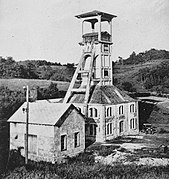
The Sainte-Marie well in the 1930s.

The power station in the 1930s.


To go
By plane
Basel-Mulhouse-Freiburg International Airport – From the airport, take either the motorway 35 to join Mulhouse then the highway 36 to reach Belfort, either go through Altkirch following the D419. In Belfort take the D619 towards Ronchamp.
By train


1 Ronchamp station – A PANG type TER station is located in Ronchamp, on the side of Bourlémont hill.
2 Champagney station – A TER station is located by the road leading to Plancher-Bas.
Belfort - Montbéliard TGV station – From this station, take the E54 (N19) to join Ronchamp.
By bus
Saônoise lines – Line 15 stops in the mining area.
By car
The D619 allows you to arrive from the east from lure / Vesoul or the West from Belfort. The E54 (N19) which connects Lure to Hericourt (and the urban air of Belfort-Montbeliard) passes a few kilometers south of the mining basin which can be reached via the D4.
Walk
GR 59 – crosses Franche-Comté from north to south
Path of the Dukes – from Montbéliard to Marckolsheim via Épinal
Circulate
Traffic is generally heavy on the main axes (D619 and D4) but remains very fluid on the other roads of the mining basin, little frequented. The parking lots are sufficient and are free. The road leading to the chapel (D264) is very narrow and curvy in places.
To make traffic more fluid and avoid saturating the parking lot of the chapel, which is the most in demand, the community of municipalities has set up a summer shuttle which has several stops: the Ronchamp TER station, the church square, the market square, the Ronchamp chapel, the ballastières beach, the ballastières campsite, the center of Champagney, the Champagney basin, a point view of the chapel, Plancher-les-Mines and the Planche des Belles Filles.
Cycling is possible everywhere and a cycle route is being developed.
To see
Touristic places
- 1 Marcel-Maulini mine museum , 33 3 84 207050, e-mail : [email protected]
 From November 1 to March 31: Tuesday to Saturday from 1:30 p.m. to 5:30 p.m. from April 1 to October 31: Tuesday to Friday from 10 a.m. to 12 p.m. and from 1.30 p.m. to 5.30 p.m. Saturday and Sunday from 1:30 p.m. to 5:30 p.m. closed May 1 and 8, August 15, November 1 and 11 and Christmas holidays.
  free at 3,5 €. – in the city center, to discover the history of the mining basin, the life of the miners and the equipment used.
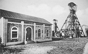
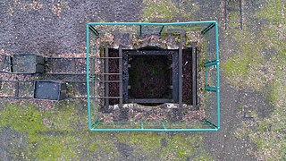
 - 2 headframe of the Sainte-Marie well free. –
 built by Charles Tournay in 1924 and the ruins of the annex buildings of the eponymous pit.
 - 3 The remains of the Étançon well free. – and the memorial to the disaster of .

The mining museum.
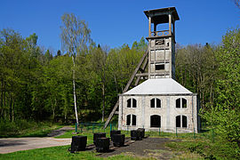
The headframe of the Sainte-Marie well.
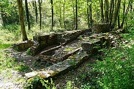
Ruins of a building in the Sainte-Marie well.
The entrance to the secure and renovated Etançon shaft.

Remains of a building from the Etançon well.


Tribute monuments
- 4 The Horsetail Cube – evokes the formation of coal.
- 5 The monument of the hamlet of La Houillère – reminder of the first mining works.
- 6 The stele of the Étançon disaster – pays tribute to the victims of this disaster.
- 7 The mine memorial – built by the association of friends of the mining museum in 2005. Representing, through mini-headframes, all the wells in the mining basin, its keyhole shape evokes the "key" to Ronchamp's economic development, which is the coal mining.
- 8 The bas relief of the miners – paying tribute to minors and their working conditions.
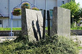
The Cube of Horsetails.

The monument of the hamlet of La Houillère.

The stele of the Étançon disaster.
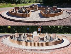
The mine memorial.
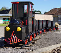
Reconstituted mine train in downtown.


Curiosities
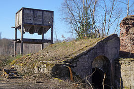
- 9 The ruins of the Arthur-de-Buyer well – located in the neighboring town of Magny-Danigon.
- 10 The remains of the coking plant and the yard – also located in the town of Magny-Danigon in the Chanois plain.
- 11 The old buildings of the Saint-Charles well – dating from the middle of the XIXe century, converted into housing and still in good condition.
- 12 The old buildings of the Magny well – dating from the end of XIXe century and beginning XXe century, converted into housing or ruin.
- The many slag heaps located in the three municipalities of the mining basin: 13 Red Heap , 14 Chanois slag heap , 15 Heap of Arthur-de-Buyer well , 16 Heap of the Magny well , 17 Heap of the Eboulet well , 18 Heap of the Saint-Jospeh well , 19 Heap of the Saint-Charles well , 20 Heap of the Sainte-Pauline well , 21 Heap of the Étançon well , 22 Eastern sinking heap .
- The many concrete slabs covering the old mine shafts, some of which like that of the 23 Tonnet well is on hiking trails: 24 Well of Hope , 25 Saint-Georges well , 26 Sainte-Marie well , 27 Well 7 , 28 Well 10 , 29 Well 11A , 30 Well 11B , 31 Notre-Dame well (extraction) , 32 Notre-Dame well (ventilation) .
- The mining towns and dormitories near the old wells: 33 City Saint-Jean , 34 City Saint-Charles , 35 City of Epoisses , 36 City of Magny , 37 City of Morbier , 38 City of Eboulet , 39 City of post chiefs , 40 City of the Platform , 41 "Castle" of Eboulet , 42 "Barracks of the Fressais" ,
.JPG/240px-PAB_(82).JPG)
Ruins of the Arthur de Buyer well.

The Arthur de Buyer well chimney.
The concrete hopper of the old coking plant.

The buildings of the old Saint-Charles well.

The Chanois slag heaps.
.JPG/240px-PAB_(82).JPG)


The slag heaps located in the Chanois plain.

The concrete slab and terminal of the Tonnet well as there are on nine other wells.

That of the Well of Hope.
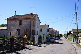
The mining town of Eboulet.


Do
Walking tours
Four pedestrian circuits allow you to discover the Ronchampois mining heritage:
- Workers' cities – (CCRC: Communauté des Communes Rahin et Chérimont), discovery of the hamlet of La Houillère and the mining works of the outcrops.
- Mines & Forests – (CCRC), discovery of the mining sites of XXe century (Chanois well, thermal power station, sorting-washing-coking plant, large slag heaps, Arthur-de-Buyer well tunnel and Magny well in parallel with a forest visit.
- Arts & History – (CCRC), visits to the main monuments of the historic center and Bourlémont hill (Notre-Dame-du-Bas church, Notre-Dame-du-Haut chapel, Stations of the Cross and Sainte-Marie mine shafts.
- Étançon outcrops trail – (AMM: Friends of the Mine Museum), discovery of the mining works of the outcrops of Étançon (galleries of the XVIIIe century and 1950s).
To buy
Eat
- 1 The country relay 83 Republic Avenue – Traditional cuisine, pizzas.
- 2 Marshal 26 rue des Mineurs – Fried foods.
- 3 Cook Restaurant 5 avenue de la République – Traditional cuisine, pizzas.
- 4 The Bistrot Comtois 33 avenue de la Republique – Wine bar, restaurant
- 5 The Blue villa 9 rue du Plain – Traditional cuisine, pizzas, on the edge of the ballast pits.
- 6 Ephesus 43 rue le Corbusier – Kebab from Ronchamp
- 7 Manzara 23 Grande Rue – Champagney kebab
Housing
- 1 Le Pre Serroux (hotel) 4 avenue du Général Brosset – downtown.
- 2 The Manor with three charms 57 rue Le Corbusier – mansion in the center.
- 3 The Park Guest House 12-14 rue du Tram – offers features close to the castle of the coal mine but it is closer to the center.
- 4 Le Rhien-Carrer hotel-restaurant 14 rue d'Orière – is further away, to the north of the town near the Le Rhien stream.
- 5 Le Ronchamp hotel 1 rue Neuve – located next to the city center park and the main roads.
- 6 Le Pre Serroux (hotel) 4 avenue du Général Brosset – downtown.
- 7 Ballastières camping-caravanning 20 rue du Pâquis – on the edge of the gravel pits towards Champagney.
- 8 Le Séquoia stopover gîte 2 Rue de la Cure, Clairegoutte
Around
- Ronchamp (City of the mining basin.) – Known for its chapel inscribed on the World Heritage List and its mining past described in a museum.
- Champagney (City of the mining basin.) – The village, very extensive in the middle of fields and forests, is best known for its dam-reservoir and its House of Negritude and Human Rights. This place of memory around black slavery is rooted in local history. He recalls that the , the inhabitants of Champagney asked, in article 29 of their book of grievances, the abolition of this form of slavery.

- Luxeuil-les-Bains (To 17 km north of Lure by the expressway and 28 km from Vesoul by the N57.) – Spa town already known in Roman times.
- lure – altitude 300 m. - 10,000 inhabitants - Paris 410 km. - Belfort 30 km, Besancon 80 km - SNCF on the Paris-Basel axis, sub-prefecture - Homeland of Georges Colomb, father of Sapper Camember.
- Fougerolles – Altitude 310 m. Paris 367 km. - Épinal 47 km, Vesoul 39, Remiremont 24, Plombières 11, Luxeuil 9 km by the N57 then the D83, in the Ballons des Vosges Natural Park.
- Saint-Valbert – coming from Luxeuil by the N57, at the crossroads for Fougerolles turn right.
- Faucogney – Altitude 363 m. - Paris 400 km. - Épinal 55 km, Remiremont 28 km, Vesoul 47 km, Belfort 44 km, Mulhouse 86 km, Besancon 105 km. Remiremont, Lure, Luxeuil stations. Regional Natural Park of Ballons des Vosges. Tour of the XIVe century, beautiful facade units, 18th century housese, fountain from the same period, Vestiges of the old priory of St Jean Baptiste, foundation of the monk St Colomban in 580 vestiges of the old fortress and the ramparts razed in 1674 - City with a long and glorious historical past, Faucogney was one of the last strongholds of Comtoise independence. The city was taken by the French in July 1674, after fierce resistance.
- Haut-du-Them-Château-Lambert – the departmental mountain ecomuseum between Franche-Comté and Lorraine
- Hericourt – To 30 km de Lure and 9 km of Montbeliard