| North Brabant | |
 | |
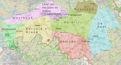
Location  | |
Coat of arms and flag  | |
| State | Netherlands |
|---|---|
| Capital | 's-Hertogenbosch |
| Surface | 5 081.76 km² |
| Inhabitants | 2 462 188 (2011) |
| Tourism site | |
| Institutional website | |
North Brabant (Noord-Brabant), often abbreviated to Brabant, is a province in the south gods Netherlands.
To know
Geographical notes
North Brabant is bordered to the north by the provinces ofSouth Holland and of Gelderland, to the west with the Zealand, to the east with the Limburg and to the south with the Belgium. It constitutes the second largest province of the Netherlands after Gelderland.
With a density of more than 500 inhabitants per km², North Brabant appears highly urbanized. The four major cities Breda, Tilburg, Eindhoven is 's-Hertogenbosch they are arranged in a circle in the center of the province. For the rest, however, North Brabant is still a rural country. To avoid the danger that the four major cities could merge with each other, as happened in the neighboring province ofSouth Holland, the protected area "Het Groene Woud" (The Green Forest) was created in the center of Brabant and any construction within it was forbidden.
Background
It is assumed that the name Brabant derives from the term Braecbant, composed of the words braec (swamp) and bans (village). According to this widely accepted theory, Brabant would mean "swamp villages".
What today constitutes the administrative province of North Brabant was part, until the seventeenth century, of the Duchy of Brabant which at the time also extended over large portions of the neighboring Belgium. The golden age of the duchy coincided with the 14th and 15th centuries. It was at that time that the cities of Brussels, Antwerp, Leuven, Breda is 's-Hertogenbosch they had their maximum flowering.
The signing of the treaty known as Utrecht Union of 1579 marked the aspiration of the Dutch provinces that had embraced the Lutheran faith to free themselves from the Spanish yoke, at the same time determining for the Catholic Brabant the beginning of a series of turbulence in the context of the religious wars that shook Europe in the first half of the 17th century.
With the Peace of Westphalia of 1648 which ended the Thirty Years' War, the northern part of Brabant was assigned to Republic of the Seven United Provinces. The population of North Brabant remained firmly anchored to the Catholic faith, despite attempts by the Republic to convert it to Lutheranism. The Republic punished the inhabitants of its new possession with the imposition of a series of heavy taxes that hampered its economic development. To escape religious persecution, the population was forced to practice their faith in secret.
The inhabitants of Brabant regained their full rights as citizens only following the invasion of the country by the French revolutionary forces and the consequent establishment of the Batavian Republic. It was a brief experiment that lasted from 1795 to 1806 and followed by the equally ephemeral kingdom of Holland established by Napoleon Bonaparte as a puppet state for his third brother, Louis Bonaparte.
The Vienna Congress of 1815 decided to create a new entity, the United Kingdom of the Netherlands whose crown was awarded to the House of Orange. This too was a short-lived experiment and ended 15 years later with the secession of the French-speaking and Catholic southern provinces that gave birth to the kingdom of Belgium.
Territories and tourist destinations
Urban centers
- 's-Hertogenbosch (informally Den Bosch) - Homeland of the painter Hieronymus Bosch, retains a magnificent late Gothic cathedral. .
- Bergen op Zoom - A thriving port in the Middle Ages with a church built on a sacrificial area from the Roman era.
- Breda - It offers its visitors an interesting Gothic church, the Grote Kerk or large church.
- Eindhoven - is a post-industrial city whose development was intimately linked to that of the multinational Philips. Thanks to its airport where Ryanair operates flights fromItaly, Eindhoven is one of the main access points to the country.
- Helmond - Named for the first time in a papal bull of Pope Alexander III, Helmond was a thriving textile center and is famous for a fairytale square castle.
- Kaatsheuvel - is a center of 17,000 inhabitants in which Efteling is located, considered one of the best amusement parks in the world similar in style to Disneyland but established three years earlier.
- Roosendaal - Town on the border with Belgium and railway junction on the line Amsterdam - Rotterdam - Antwerp - Brussels - Paris.
- Tilburg - University town.
- Waalwijk - Town of medieval origin.
Other destinations
- Nationaal Park De Biesbosch
- Nationaal Park De Loonse en Drunense Duinen
- Nationaal Park de Groote Peel
- Strabrechtse Heide
How to get
The region has a dense network of highways and railways and forms a transport hub between the ports of Rotterdam is Antwerp and the Ruhr basin at East.
By plane
The airport of Eindhoven it is the only airport in the region reserved for passenger traffic.
The River Meuse (Maas in Dutch) which originates in France and marks for a long stretch the border between North Brabant and Limburg, before joining the Rhine, it is navigable. The main river ports on this stretch of its course are Cuijk and Oss. Through the Zuid-Willemsvaart and Wilhelminakanaal channels and their branches it is possible to reach these two ports from the cities of 's-Hertogenbosch is Tilburg with small boats.
On the train
Thalys high-speed trains, operating on the line Paris-Brussels-Amsterdam, they cross the territory of Brabant without, however, making any stops. On the other hand, there is a domestic high-speed train service from the airport of Schiphol to Antwerp with intermediate stop a Rotterdam from which a branch for the city of Breda.
How to get around
In addition to the Meuse river mentioned above, the Zuid-Willemsvaart canals can be navigated by small boats, which has a branch for the capital. 's-Hertogenbosch and the Wilhelminakanaal canal which runs through the city of Tilburg.
What see
What to do
At the table
Safety
Other projects
 Wikipedia contains an entry concerning North Brabant
 Commons contains images or other files on North Brabant