The Burgwald is a small mountain range in Hesse. The wooded hill country can be found between Marburg and Frankenberg.

places
&groups=Maske,Track,Aktivitaet,Anderes,Anreise,Ausgehen,Aussicht,Besiedelt,Fehler,Gebiet,Kaufen,Kueche,Sehenswert,Unterkunft,aquamarinblau,cosmos,gold,hellgruen,orange,pflaumenblau,rot,silber,violett)
- 1 Münchhausen (am Christenberg)
 in the encyclopedia Wikipedia")
 in the media directory Wikimedia Commons")
 (Q582545) in the Wikidata database")
- 2 Rauschenberg

- 3 Rosenthal (Hesse)
- 4 Weather (Hessen)
- 5 Burgwald (municipality)


background
The castle forest gives just as much to the forest hiker as he does Kellerwald. It is a very extensive forest area with beautiful nature, ideal for lonely and relaxing walks.
getting there
Larger places from which you can make day trips are: Marburg, Battenberg (Eder), Frankenberg (Eder), Bad Wildungen, Bad Arolsen, kassel, Korbach
By train
The new route of the Kurhessenbahn also offers more possibilities again.
mobility
Visiting the castle forest is very cumbersome by public transport. The interesting places can only be easily reached with your own vehicle.
Tourist Attractions
- 1 Church on the Christenberg (Nice view of that Rothaar Mountains)
- 2 Mellnau castle ruins. beautiful view u. a. to the southern Burgwald and towards the Lahn valley. Access ? Location: 50 ° 55 '46 "N.8 ° 44 ′ 54 ″ E.
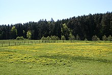
- 3 French meadows. The boggy wet meadows with ponds and alluvial forests are located in the middle of the castle forest and are a habitat for rare plant species. Location: 50 ° 56 ′ 50 ″ N.8 ° 48 '34 "E. . From the summit of the Christenberg it is approx. 4 km to get there.
- 4 Court oak on Galgenberg. at Rosenthal. The striking 300-year-old English oak stands about 1 km east of the city center in the open field on the Galgenberg (also known as the goose mountain). The natural monument has a circumference of 7 m.: Location: in the area of the country road to Haina. The tree can be reached from the street via an asphalt farm road.


activities
hike
- There are some hiking trails that meet high standards, as in Hiking trails with a seal of approval are described.
- The Burgwald offers 10 award-winning quality circular hiking trails. On the hiking page of the Burgwald-Ederbergland region, the 10 tours are detailed with maps, elevation profiles and route descriptions presented.
- A route is called that "Dream route Burgwaldpfad"(Good markings with a red "B" on a white background. Overall, you would do the 51 km between Frankenberg (Eder)(Railway station)- Marburg(Elisabethkirche) need about 14 hours. So if you are not an extreme hiker, you need stages.
- Some information on this external site.
- The Eibenhardt path is a 6.4 km long circular route on the edge of the castle forest. Reddehausen forest car park via B3 to Cölbe-Reddehausen
Cycling
The regional cycle route network was re-signposted by mid-May 2011: There are now the following regional cycle routes in the region:
- Burgwald cycle path - 40 km long circuit that opens up the central Burgwald with the Franzosenwiesen from the south.
- Lahn-Eder cycle path - Approx. 30 km from Cölbe near Marburg to Frankenberg (Eder) along the Weather.
- Practical: the Burgwaldbahn runs parallel to the route. You can combine tours with the train.
- Treisbachtal cycle path - 21 km long route in the Ederbergland to Wetter.
- Otto Ubbelohde cycle path - 51 km long circuit in the castle forest and in the area of the valleys of Asphe and Wetter.
- Ohm-Eder cycle path - 45 km from Frankenberg via Gemünden to Kirchhain.
In addition, the Hess. Long distance cycle route R 6 the region. An overview map of the routes as a PDF file is available on the website of the Burgwald Touristservice to find.
- 1 Outdoor and more, Frankenberger Strasse 23. Tel.: 49 (0)6451 71 54 45..
kitchen
- 1 Waldgasthaus Christenberg, Christenberg 3, 35117 Münchhausen. Tel.: 49 64573 68 57. Open: Monday and Tuesday closed, otherwise 11:30 a.m. to 9:00 p.m.
nightlife
security
climate
literature
- Cycling and hiking map "Burgwald / Kellerwald" 1: 50,000, ISBN 978-3937929798 , 1st edition July 2007, € 3.50, published in Cartographic Municipal Publishing Company Nordhausen
Web links
- Burgwald Tourist Service - officially