| Cojedes | |
 | |
Location 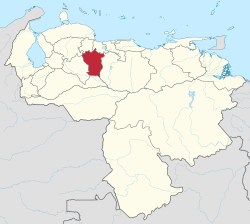 | |
Coat of arms and flag  | |
| State | Venezuela |
|---|---|
| Capital | San Carlos |
| Surface | 14,800 km² |
| Inhabitants | 348.022 (2015 census) |
| [link not working]Institutional website | |
Cojedes is one of the federated states of Los Llanos in Venezuela.
To know
Being largely rural, its main tourist attractions are in the middle of nature. Among the most notable is the Hato Piñero, where hundreds of species of wild animals live free and protected by an ecological foundation. The capital San Carlos is known for its racetrack, where 4 World Championships were held.
The state takes its name since 1855 from the Cojedes River, which originates in the state of Lara. The name Cojedes has a Caribbean origin, meaning "pottery people" or "potters' village.
Geographical notes
It is located in the central-western part of the country and is bordered to the north by the state of Lara, Yaracuy is Carabobo, to the west with the state of Portuguesa, south with the state of Barinas and to the east with the state of Guárico.
Most of the territory is flat and included in the region of Los Llanos, that is, that of the central plains. In the northern part there is a hilly and mountainous area part of the central cordillera whose highest peak is the Cerro Azul de Tucuragua with 1,780 m a.s.l.
Territories and tourist destinations
Urban centers
- San Carlos - Capital of the Federated State of Cojedes.
- Tinaquillo - It is located on a plateau on the banks of the Tamanaco River.
Other destinations
- Hato Piñero - East of El Baul, where an ecotourism has developed for the diversity of free wildlife, combined with typical farm activities where visitors can participate in the same activities carried out by Llano del Hato. This farm is visited by foreign tourists and researchers of various nationalities.
- Balneario Boca Toma National Park (Parque Balneario Boca Toma) - It is located in Avenida Ricaurte, a San Carlos. In a mountain climate you can bathe in its crystal clear waters. On the banks of the river Boca (or Tiriguá) there are cottages with a barbecue area to prepare the traditional stew in the middle of the green. The seasons in which there is the most influx of tourists to this pleasant river are Carnival, Easter and the school holidays (July to September). Sporting events are also held there.
- General Manuel Manrique National Park — (Parque Nacional General Manuel Manrique or Tirgua) - Located between Cojedes and Yaracuy it has an area of 12,200 hectares. It is a protected ecosystem, declared a National Park on 5 June 1992, with important natural attractions, such as deciduous and semi-deciduous forests.
How to get
How to get around
What see
- Autodromo de San Carlos - The international racetrack of San Carlos it is located on the outskirts of the city and is home to numerous important national and international racing car and motorcycle races. The state of Cojedes racetrack is known for hosting 4 world motorcycling races between 1976 and 1979 as well as major Formula 1 events.
- Aguas Termales la Aguadita - Sulphurous waters a Tinaquillo, about 1 km from the village of Aguadita.
- El Salto - Stream of clear water in the Tinaco River.
- Embalse Conchinche - Irrigation system on the Pao River which serves an area of 600 hectares and provides water supplies for the city of Valencia.