
The Hohe Hagen is an approximately 492.5m high mountain of volcanic origin in the Dransfeld Stadtwald, a low mountain range in the near Dransfeld southern lower saxony District of Göttingen. It is the highest point in the Dransfeld area.
geography
location
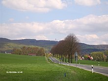
The Hohe Hagen rises about halfway between Goettingen in the northeast and Hann. Münden in the southwest in the Münden Nature Park in the areas of the city of Dransfeld (about northwest and northern parts), where its summit is also located, the municipality of Jühnde (eastern flank) and the municipality of Scheden (southern flank). The summit of the mountain on the eastern edge of the Dransfeld city forest is about 3 km south of the Dransfeld core town. The source of the Auschnippe lies a little to the northwest of the Hohe Hagens, between the hills Brunsberg in the east and Hengelsberg in the west. The Dramme tributary Häger Graben rises on the northeast flank.
After the Haferberg, the two equally high Steinbergen (Großer and Kleiner Steinberg (Kaufunger Wald) | Kleiner Steinberg; and other mountains in the Lower Saxony part of the Kaufunger Forest or in the Münden Nature Park, the Hohe Hagen is one of the highest mountains in the southern tip of the state of Lower Saxony.
Mining
Basalt was mined on the Hohen Hagen until 1971. The disused basalt quarry is not far from the hiking car park. The history of the basalt quarry can be experienced since autumn 2004 through a geology and mining trail.

Gauss tower
The 32 m high observation tower was built on the Hohen Hagen from 1909 to 1911 Gauss tower built from basalt rock. In 1963 it collapsed due to loosening of the soil caused by blasting in the neighboring quarry. The tower was not rebuilt.
In 1964, the 51 m high New Gauss Tower made of reinforced concrete, a broadcasting and viewing tower with a panorama restaurant, was built at a neighboring point. From its viewing platform at a height of 528 m, the all-round view not only falls over the Dransfeld city forest, but also to, among other things Solling, to Goettingen with the Göttingen Forest and beyond resin as well as for Hohen Meissner, Kaufunger Forest, Habichtswälder Bergland and Bramwald with beyond Reinhardswald.
House Hoher Hagen

The house is located on the (today's) summit region of the Hohen Hagens, about 180 m north-northwest of the Gauss Tower, in the middle of the forest High Hagen, a former mountain inn built in 1914, which has been used as a school camp and educational facility since 1982. The sponsors are the Friends of the Georg Christoph Lichtenberg Comprehensive School Göttingen, the Otto Hahn Gymnasium Göttingen and the Association for extracurricular education e. V. The self-catering house has 40 beds and is rented to groups.
getting there
On foot
The runs over the mountain European long-distance footpath E6, which is here in the normal route and one after Hann. Münden dividing leading variant. In addition to local walking and hiking trails (geology path) that lead across, the mountain is also the station of the Student path between the places Rosdorf and Scheden and des Loccum – Volkenroda pilgrimage route between the places Dransfeld and Early.
By bicycle
The Weser-Harz-Heide-Radweg used to lead over the summit of the Hohen Hagens, in the meantime the route has been relocated so that the cycle path now leads past the foot of the Hohen Hagens. From Dransfeld or Scheden there is a detour via the summit. The path from Dransfeld is paved, but is also used by motorized traffic. Another paved path leads to the summit on the west side of Jühnde.

Cycling
Since 2004, a section of the route with a mountain classification of the third category of the International Lower Saxony Tour for professional cyclists has been running on the road leading over the Hohen Hagen and, since 2005, the everyone's race with start and finish in Goettingen. The Hohe Hagen is the local mountain of the RSC Hoher-Hagen cycling club, which is committed to popular sport for mountain bikers and racing cyclists around the Hohe Hagen. The annual road race Tour d'Energie leads over the summit of the Hohen Hagen
literature
- Friedel Rehkop: City of Dransfeld. A historical look back from the 19th century to the early days. Volume 1. Geiger-Verlag, Horb am Neckar 1999, ISBN 3-89570-561-6 , Pp. 196-200, 352-360, 387-397.
Web links
- High Hagen. wiki-goettingen.de
- Haus Hoher Hagen - school camp, conference center, educational facility. haus-hoher-hagen.de
- Dransfelder Hasenmelkerlauf. Endurance sports club (ASV) Velo-Venezia Dransfeld e. V., on hasenmelker-lauf.de