|
|  | |||||||||
.svg/100px-Easter_Island_on_the_globe_(French_Polynesia_centered).svg.png)
Understand

Also known as Te Pito or Te Henua ("The navel of the world" in the native language), Easter Island subsists economically on tourism and fishing. More than 5,000 people live on the island, concentrated in the only populated center, Hanga Roa.
History
_LACMA_M.2008.66.6_(1_of_3).jpg/170px-Ancestor_Figure_(moai_kavakava)_LACMA_M.2008.66.6_(1_of_3).jpg)
According to oral tradition, the Rapanui people would have come to this island from the mythical island of Hiva, being guided by Hotu matu'a, his first ariki (king), around the 4th century. According to archaeological investigations, the origin of this ethnic group would come from Polynesia, possibly from the Marquesas islands, although there are some who postulate a South American origin.
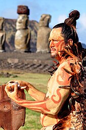
Rapanui society was strongly stratified into tribes and classes, which inhabited defined spaces on the island. While the coast was the space for religious, political and ceremonial centers, the population lived in the interior along with their crops. Within their traditions was the veneration and almost deification of the ancestors, in whose honor they would have built the enormous monolithic sculptures today known as moai. These sculptures were carved in volcanic rock in quarries in the interior of the island, being later transported towards the coast and located in a ceremonial center known as ahu; how these huge statues are transported, as well as their actual meaning, remains a mystery. This culture also developed a writing system known as rongo rongo.
By the 15th century, the island would have had more than 6,000 inhabitants, some estimates reaching 30,000. The construction of the moai, the growth of the population and the over-exploitation of agriculture contributed to the deforestation of the island and an environmental crisis that affected society as a whole. Maritime resources were depleted and the population began to suffer from a lack of food. The complex society fell apart and the clans competed for the few resources that existed. Oral tradition tells of the development of a civil war between the Hanau momoko ("Short ears", the common people) against the leaders Hanau Eepe ("Long ears"); the altars were destroyed and the quarries were abandoned with half-built moai. It is speculated that the natives began to live in caves to defend themselves from the attacks and that they even went as far as cannibalism to survive.
On Sunday, April 5, 1722, the day of the Easter, the dutch navigator Jakob roggeveen He arrived on the island and began the process of communication between the island and the rest of Western civilization. About 2,000 people lived on the island at that date. After this expedition, several other European navigators arrived in the following years and there was permanent contact with the French colonizers who settled in Tahiti. In the mid-19th century, Peruvian merchants arrived on the island and enslaved hundreds of inhabitants and transferred them to the haciendas and guaneras in South America. A dozen managed to survive slavery and, upon returning to the island, they transmitted diseases such as smallpox to the rest of the population. The island reached its maximum crisis, with just 110 inhabitants in 1877.
By the middle of the 19th century, contact had developed between islanders and Catholic missionaries in Chile. Faced with France's refusal to establish a protectorate and the serious social crisis on the island, some islanders requested support from the Chilean government. In 1888, the Chilean sailor Policarpo Toro signed a disputed agreement with the island's leaders, after which the sovereignty of the South American country over the island was established. The incorporation of Easter Island into Chile, however, did not change the situation. The government decided to lease the island to sheep farmers, who subdued the population. It was not until 1952 that the Chilean government canceled the island's concession due to the mistreatment of the population, and in 1964 it was only incorporated into Chilean civil territory. In 1967 the Mataveri airport was inaugurated, which allowed the island to connect with the rest of the country. In the following years, several reforms have been carried out that have allowed the islanders to provide a better quality of life and strengthen their native culture, although some outstanding debts remain and movements that demand greater autonomy and even independence have been strengthened. In 2003, a statute was approved that gave the island the quality of "special territory", but the statute that specifies the autonomy of said territory has not yet been approved.
In May 1960 the Valdivia earthquake on the Chilean coast, which caused a tsunami that reached the small Easter Island after crossing the entire Pacific. This caused significant damage to the ahu from the eastern coast of the island, the sea pulling the moai that were still standing. After this, there have been programs for their recovery and restoration, thanks to the support of some friendly governments, which have restored them to the state in which we find them today.
Geography

The island is shaped like a right triangle with sides of 16, 17 and 24 kilometers. This shape is given by the volcanic origin of the island: three inactive volcanoes are located in the corners of the island. To the north is the Maunga Terevaka, which with 511 meters of altitude is the highest point of the island; To the southeast is the Poike peninsula, with its main volcano, Puakatiki, which is 377 m high, and to the southwest is the crater of the Rano Kau with 324 m, in whose interior there are several lagoons. Other important hills are Rano Aroi and Rano Raraku.
The rest of the island corresponds to hills and slopes. The coast, meanwhile, is steep and rocky with a series of nearby islets, such as Motu Nui, Motu Iti and Motu Kao Kao in the extreme southwest, Motu Tautara islet on the west coast and Motu Marotiri on the west coast. The only exceptions are the coastline off Hanga Roa and the sector Anakena, where the beach of the same name and the beach of Ovahe.
The island, which was once covered by large forests, today is an arid terrain, covered by grass and some palm trees. All endemic trees are extinct except the toromiro that managed to develop in other latitudes and there are plans to reintroduce it on the island. Among the endemic fauna there are some rodents and lizards, as well as several species of birds that reach the island's coasts and even some turtles. The waters surrounding the island are rich in species of fish and shellfish.
Further from this nucleus is the Sala and Gómez island, administratively belonging to Easter Island, but which is uninhabited. Known by the Rapanui as Motu Motiro Hiva, who went to the island to collect feathers and eggs from the birds that inhabited the island, has the same volcanic origin as Easter Island. The island has an area of 0.15 km², with an irregular surface and in which there is hardly a place to land helicopters.
Weather
| Weather | Jan | Feb | Sea | Apr | may | Jun | Jul | Aug | Sep | Oct | Nov | Dec |
|---|---|---|---|---|---|---|---|---|---|---|---|---|
| Maximum recorded (° C) | 36 | 36 | 36 | 35 | 30 | 35 | 31 | 32 | 32 | 32 | 32 | 33 |
| Maximum (° C) | 27 | 27 | 27 | 25 | 23 | 22 | 21 | 21 | 22 | 23 | 24 | 25 |
| Minimum (ºC) | 20 | 20 | 20 | 19 | 18 | 17 | 17 | 15 | 16 | 16 | 17 | 18 |
| Recorded lows (° C) | 15 | 16 | 7 | 3 | 10 | 7 | 9 | 7 | 10 | 3 | 7 | 12 |
| Precipitation (mm) | 73 | 85 | 96 | 121 | 153 | 106 | 105 | 94 | 87 | 68 | 74 | 86 |
The island has a cool tropical climate, in which winters are combined with cool nights but without frost. The average annual temperature is 20.5 ° C, reaching its maximum of 23.7 ° C in February and the minimum of 18.0 ° C during August. It has a little thermal oscillation during the day, a product of the maritime influence. Rainfall, for its part, is distributed regularly throughout the year and there is a high humidity, close to 80% permanently.
To get

The only realistic way to reach the island is through the air connection that maintains LATAM with the Mataveri airport (CPI). Mataveri is known as the most remote airport in the world, being 2603 km from the nearest airport (Mangareva, French polynesia, although it does not have routes in common with it). The airport was built in 1965 as a low-use station, but in 1986 an agreement was reached with the POT to expand its runway and establish it as a landing alternative for space shuttles. This made it possible to increase the flight frequencies of traditional airlines and boost tourism to the island.
As of August 1, 2018, Law No. 21,070 begins to govern, which establishes a special migration regulation for the island, which seeks to protect the environment and its culture and allows a maximum of 30 days to remain in it, in addition to Santiago airport will require your identification document (it can be a passport) round trip ticket; and reserve in an accommodation authorized by SERNATUR. For more information visit https://www.gob.cl/rapanuiprotegida/
Every day there is a flight between Santiago de Chile and Easter Island, which lasts for 5:25. This flight, once a week, continues until Papeete, on the French polynesia. LATAM opened in 2011 a route between Easter Island and lime, Peru, with a frequency of twice a week, but in March 2013 it was canceled.
For the more adventurous, there is an option by sea from the port of Valparaiso. The Chilean Navy makes two supply trips a year (without fixed dates, but close to May and September) in which some passengers can embark. Tourists must request permission from the Commander in Chief of the First Naval Zone and, if there are quotas, they will be able to get on the ship. The trip is considerably cheaper than the air option (in the range of $ 100 000), but it lasts 7 days and you must have the physical conditions to support this trip across the Pacific. In addition, it is mandatory to return in the same ship (which stops a few days on the island) or to have a guaranteed return air ticket.
Travel
Despite its small size, touring the island is not an easy task. Its surface is covered with hills, grasslands and archaeological ruins, with a few hardly demarcated roads. Only the streets of Hanga Roa and the road to Anakena are paved.
Mataveri airport is located on the outskirts of Hanga Roa, the island's capital. You should have no difficulty getting to your hotel from there; they will most likely be waiting for you if you tell your hotel to do so. There are also various taxi services that can take you to the corners of the island that you want to know; within Hanga Roa, the price should not exceed $ 1500, and for other places you will have to negotiate it with the driver.
There are many tour services that allow you to visit the main attractions of the island, with guides who explain the Easter culture and the history behind each archaeological remains. There are tours that last half a day (3 hours and around the $ 25 000) and others full day (6 to 7 hours, approx. $ 35 000). Most agencies have guides in Spanish and English, and you can find some also in German, French and Portuguese. In the Chilean Government tourism site You can find contact with independent guides, tour agencies and other services (some certified); Here is a list of some tourism services available on the web:
Many tourists wish they had enough freedom to tour the island's various landmarks at their own pace. For them, it is advisable to rent an all-terrain vehicle. Prices will vary depending on the model and time, but can be between the $ 25 000 and the $ 60 000. Bicycles are a good alternative for those who have experience in these, as the terrain is complex. A mountain bike should not exceed $ 15 000 per day.
Regardless of the form of travel, keep in mind that the main points of interest of the island (Orongo, Rano Kau, Rano Raraku, Anakena, etc.) are within the Rapa Nui National Park, administered by Conaf. To enter, you must pay an entrance fee of $ 30 000; children under 12 years old pay $ 5000 and the Chilean adults, $ 10 000. These tickets are usually not considered within the tourist packages. The National Park is open from 9:00 a.m. to 6:00 p.m. (between December and March, it closes at 7:00 p.m.). [1]
Know
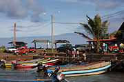
The starting point of any tour of Easter Island is from its only town, Hanga Roa. This small cove concentrates a large part of the island's services, but also some buildings of interest. Among them is the Parish churchUnknown parameter: lonWrong coordinates, which fuses Catholicism with the traditional culture of the island; Although it is reflected with the naked eye in the wooden religious figures within the church, it reaches its climax at Sunday Masses when an important part of the local community gathers. Also in the village is the 1 Father Sebastián Englert Anthropological Museum (Tue-Fri 9: 30-17: 30, Sat-Sun and holidays 9: 30-12: 30; general admission: $ 1000) with an interesting collection that portrays the history of Rapanui culture. The 2 Fishermen cove With its multi-colored boats it is also of interest to understand a little of the local economy and way of life. There he will surely have his first approach to the famous moai, having a ahu next to the cove. A little further south of Hanga Roa is another traditional cove, 3 Hanga Piko, which you can visit in the morning and observe how the fishermen work.
Without a doubt, the main tourist attraction of the island are the moai. Although you can find several scattered around the island, these are usually concentrated grouped on platforms called ahu. Remember that the moai are ancient archaeological pieces, so please have respect: avoid touching them or walking on them. ahu. Most of the ahu they are located around the coast. Those closest to Hanga Roa, not counting the 4 Ahu Tautira in front of the cove, they are 5 Ahu Ko Te Riku, 6 Ahu tahai Y 7 Ahu Vai Uri found in the vicinity of the museum. Following the north coast, there are some ceremonial centers of interest such as 8 Ahu Tepeu, in whose surroundings you can see remains of I'll do it, old houses with elliptical shape. Nearby is the 9 Ahu akivi, the only one located inland and whose seven restored moai face the sea, the only ones that do so on the entire island.
|


On the south coast of the island you will find most of the archaeological areas. In the southeastern corner of the island, is the 10 Rano Kau volcano which delivers one of the most unforgettable postcards on the island. From the edge of this ancient volcanic crater you can see the vegetation and the various lakes that have covered its surface. Between the crater and the sea is the ancient ceremonial village of 11 Orongo, from where you can also see the islets of 12 Motu nui, 13 Motu iti Y 14 Motu kau kau and that they were the places where the Manutara (man-bird) ceremony was performed. Traveling the south coast towards the east, it is possible to observe the highest concentration of ahu until you reach the largest on the island, the 15 Ahu Tongariki. In it there are fifteen moai aligned on the platform, around which are other archaeological remains and petroglyphs. Close is 16 Rano Raraku, another extinct crater similar to Rano Kau, but which is famous for being the main quarry on the island. There you can still see the largest moai on the island, but they are unfinished, without being detached from the rock, which is considered as proof of the rapid collapse of classical Rapanui society.
|
.jpg/180px-Easter_Island,_Rano_Kau_(6691697977).jpg)


The island also stands out for its natural beauty. Among its attractions is being able to explore its hills, either on foot or on horseback. One of the most common routes is to climb to the top of the 17 Maunga Terevaka, the highest point of the island with its 507 meters above sea level, and observe from there all the corners of the island. At the eastern end, the Poike peninsula is characterized by its wild nature and requires a day or two to explore it. In this place, tradition tells that the Hanau momoko and the Hanau Eepe during the collapse of the Rapanui civilization. A still demarcated ditch would have served as a trench for the High Castes, who were later massacred by the Hanau momoko when they managed to pierce it. Several caves exist on the island, some of which can be visited and some of which cannot. One of the most famous is the 18 Cave of the Virgins (Ana O Keke) located in Poike or the 19 Two windows, in the north of the island.
Although small in size, the island has several remarkable beaches. The most famous is 20 Anakena, located in the northeast of the island and that dazzles with its white sand and the nearby moai that frame it, making it perfect for a postcard. 21 Ovahe, a little further west, it is surrounded by some cliffs that make it difficult to access but it is one of the most beautiful places on the island. Meanwhile, to the north of Hanga Roa there are some very small beaches that you can enjoy without going too far from your hotel. The diving It is one of the most interesting attractions on the island, being able to enjoy the underwater coral beauties throughout the year; Several companies offer quick diving courses and then venture to places like the Motu Nui islet.
|

.jpg/180px-Anakena_Beach_-_Easter_Island_(5955846799).jpg)
.jpg/180px-Ovahe_Beach_-_Easter_Island_(5962068471).jpg)

To buy

Most of the stores are located in Hanga Roa. There are several handicraft and souvenir shops that in most cases evoke the moai in the most different ways. These souvenirs can be found, almost without differences, in the main attractions of the island, being sold by locals.
Although some places accept credit cards, the normal thing is to use cash, so always keep a significant amount of coins and bills. Those who accept to use a card usually charge an additional 10% to 20% for transaction costs. The local currency is Chilean peso But, unlike what happens on the continent, it is common for businesses to accept US dollars and, to a lesser extent, euros. Be careful with arriving on the island with other currencies, as they will not be accepted; This is especially important if you are coming from Tahiti, where is the CFA franc.
The island has two bank branches, one of the State Bank and another from Santander. Both have ATMs, although in the first bank they only operate the MasterCard line and in the second both Visa and MasterCard. Two other ATMs are in the Mataveri lobby and at a gas station.
Eat and drink

There is an important variety of restaurants on the island, especially for tourists. Although many accept credit cards, they usually charge an additional percentage, so paying in cash is still a good alternative. Despite the number of restaurants, do not think that the food is very different between them: much of the food that arrives on the island is imported, so the variety is usually restricted. The great exception is fish and shellfish, which are a must to taste during your stay. The tuna it is probably the most common species and you can try a variety of dishes that use it.
Although it is not typical of the island, the pisco it is the most common variety of alcohol. You can try the famous Pisco Sour wave fish (pisco with Coca-Cola). Only if you have experience and stamina, you can try pisco without mixing, since it is a strong brandy (usually around 40 °).
Most of the restaurants and bars are located along Atamu Tekena Street and its adjacent streets. If you don't have as many resources or want to try something more indigenous, you can look for the empanadas and sandwiches places located along the main street. Also, there are several small supermarkets and warehouses where you can stock up, especially if you are planning a trip on your own.
- Aringa Ora. Among the largest on the island, with simple and cheap food. High call.
- 1 Au bout du Monde. Belgian restaurant, dedicated to food of marine origin. It offers dance shows.
- Bonbon Chinoise. Polynesian, Peruvian and Thai food, as well as local dishes.
- 2 Hetuʻu. Good food and attention, try the shrimp, tuna and soup.
- 3 La Taverne du Pêcheur. Located in the port, dedicated to fish and seafood. It is one of the most expensive on the island.
- 4 Te moana. One of the most popular restaurants on the island, usually with bands. Arrive early.
- Varua. Relatively new, it has typical island food at a good price. Offers daily menus from $ 9000.
Sleep
.jpg/220px-Tauraa_Hotel_-_Hanga_Roa,_Easter_Island_(5955838219).jpg)
The island has a wide hotel capacity, although few areas can be classified as hotels properly so. Most correspond to shelters, cabins, hostels and residential.
Among the hotels, the top-of-the-line are the Hotel Rapa Nui, the Altiplánico and the Explora, the latter being the only one not located in Hanga Roa. These hotels generally have a natural architectural line that combines with the rustic environment of the island. Other cheaper hotels offer simpler rooms but with quality services. There are also options for hostels and cabins, especially for larger groups. Most of the hotels and residential areas are run by their owners, who usually also have bicycles, contact with tourist guides and other services for the traveler, so do not hesitate to ask them about anything. Please note that free camping is prohibited on the island, so only use clearly marked camping sites if you wish to do so.
One of the most recommended alternatives is to stay in the house of an islander. Several places offer rooms in their houses, which allows the tourist to know the way of life of the Rapanui people. It may not provide the same comfort as a hotel, but it will surely be a unique experience for those who want to know more about Easter Island.
- 1 Morerava Cabins, Vai Kia Kia s / n. ☎ 56-2-2335 8978. 4 cabins with barbecue, Internet and bicycles.
- Easter Island Hostel, Atamu Tekena s / n. ☎ 56-9-8720 0472, ✉: [email protected]. Simple hostel on the main street of Hanga Roa. Bedrooms with kitchen and shared bathroom, does not include breakfast.
- 2 Explore Rapa Nui (Mike Rapu Inn), Camino Vaitea-Anakena s / n. ☎ 56-2-2395 2800. 6 km from Hanga Roa, rooms from $ 2500 per person for three days.
- 3 Hotel Altiplánico, Lot E Sector Hinere. ☎ 56-2-29584289 (Bookings), 56-32-255 2190 (hotel). It has a swimming pool and Wi-Fi in common areas. Single room for $ 350 daily.
- 4 Hotel Rapa Nui, Avareipua s / n. ☎ 56-32-283 2944, 56-32-312 0815. Single, double and triple rooms from $ 57 000It has breakfast included and free Internet.
- 5 Hotel O'Tai. ☎ 56-32-210 0250. Located near the post office, it is one of the most popular. 40 rooms with air conditioning and private bathroom. It has a swimming pool.
- 6 Inaki Uhi, Atamu Tekena s / n. ☎ 56-32-210 0231. In the center of Hanga Roa, it has 15 rooms with private bathrooms. Reasonable prices.
- 7 Kona tau, Avaraipau s / n. ☎ 56-32-210 0321. Basic rooms at low costs, close to $ 10 000 the night.
- 8 Tauraʻa Hotel, Atamu Tekena s / n. ☎ 56-32-210 0463. Five minutes from the airport, it also has a tour service.
- 9 Tekarera. ☎ 56-9-8134 5757. It has three spaces: Kainga Ora in the center, Tekarera Inn and Kainga Nui, near the museum.
- 10 Tupa Hotel, Sebastián Englert s / n. ☎ 56-32-210 0225. 30 rooms, some with a good ocean view, two blocks from the main street. Free breakfast and Wi-Fi in the lobby.
Talk
|
Spanish is widely spoken on the island, being the official language on many occasions. Most of the Rapanui locals speak it, although with a particular accent. Being a mainly tourist place, many locals speak English (to a greater or lesser extent); French, with which the Rapanui have had long contact, is also quite common.
However, the greatest characteristic of the inhabitants is the use of their own language, the Rapa Nui. It is one of the few original peoples of Chile that still largely conserves the use of its language. On the island you can listen to the locals using it when talking to each other, whether in private or public settings. Rapanui is a language of Polynesian origin, very similar to Tahitian or Maori, but with its own constructions derived from its years of isolation and its contact with French and Latin Americans. It has ten consonants and is pronounced very similar to what Spanish would be, except for some longer vowels than in this language and the use of a deaf consonant, `, also called glottal occlusion.
Culture

Along with its natural beauty and the mystique of its archaeological remains, it is the living culture of Easter Island that makes it a unique place. They are its own inhabitants, with their rich traditions and their own language, one of the main attractions of the island.
Dance and music, as in other corners of Polynesia, is one of the best known expressions. During your stay on the island you will find several places with artistic shows that show the traditional dances of the island. The best time to do this, however, is during the feast of Tapati, which takes place annually during the month of February and lasts about 10 days. In this festival a series of ancestral ceremonies are carried out such as the body painting competition (Takona), the telling of epic stories and legends (Riu) and the descent at high speed down a hill of young people on banana trunks (Haka Pei). The festival culminates with the election of the island's queen, who is crowned on the first full moon of the month. On this holiday, locals often invite tourists to join in the activities, which is a unique opportunity to feel part of this culture. However, keep in mind that many tourists want to attend Tapati so the hotel capacity is usually full on those days.
Locals have great respect for their traditions, so avoid making fun of or belittling them. Avoid referring to them as Chileans, because despite being legally one of them and in many cases sharing customs with "the you count"They prefer to identify with their local culture. Also be very careful with the archaeological remains of the island: do not walk through places that are not allowed, do not move stones or play with the remains, which are sacred spaces for the ancient Rapanui culture. It is not only a lack of respect and culture, but you can also be fined for that. In recent years, the rise in the number of tourists has caused several uncomfortable situations in which they have destroyed and damaged archaeological remains. This has caused unrest in many Rapanui, who feel that their island is being invaded by tourists and that there is no sustainable management of the flow of immigrants.
|


Security
The island has a hospital and a pharmacy that can treat illnesses or accidents in case you suffer any. The hospital has a certification Wilderness First Reply, so they can treat many emergencies despite the remoteness. However, keep in mind that a much more serious or rare ailment will surely require a transfer to the continent that can take several hours.
Therefore, avoid risky situations and follow the instructions. Avoid venturing into caves that are not signposted or directly prohibited, follow the marked routes and do not go into unknown places. If in doubt, ask the Conaf staff who are in the National Park.
References
external links
 Wikipedia has an article on Easter Island.w: Easter Island
 Wikimedia Commons houses multimedia content about Easter Island. Commons