 Parque Metropolitano de Santiago | ||
| Santiago de Chile | ||
| region | Metropolitan Region of Santiago | |
|---|---|---|
| Residents | 6.257.516 (2017) | |
| height | 521 m | |
| Tourist info web | www.gobiernosantiago.cl | |
| no tourist info on Wikidata: | ||
| location | ||
| ||

Santiago de Chile is the capital of Chile and is located in the geographical center of the country, on the western slopes of the Andes. In the Metropolitan Region of Santiago About 40% of the population of the Pacific state live with over 6 million people.
The city is known as the modern financial center of one of the most developed countries in Latin America, but also for its picture-perfect location in the central valley (Central Valley) just a few kilometers west of the snow-capped Andean peaks. Because of the numerous earthquakes that repeatedly struck the city, there are comparatively few historical buildings.
Districts

The center
with the district of Santiago and the artists' quarters Barrio Lastarria and Barrio Paris-Londres
The city center of Santiago ("El Centro") offers most of the architectural and cultural attractions and is the economic center of the city and the country.
The northeast
with the districts of Providencia, Las Condes, Vitacura and Lo Barnechea
To the east of the center rises a modern financial center, also known as "Sanhattan" because of its high-rise buildings. Further towards the Andes there are predominantly upscale residential areas of the upper class.
The East
with the districts of Ñuñoa, La Reina, Macul and Peñalolén
The east of Santiago, which is not very interesting for tourists, mainly offers living space for the middle and lower classes.
The southeast
with the districts of La Granja, La Florida and Puente Alto
Also in the south-east you shouldn't expect much to see; Puente Alto can be unsafe at times, but the first wine-growing areas are already joining south of the urban area.
The South
with the districts of San Miguel, San Joaquín, Pedro Aguirre Cerda, Lo Espejo, San Ramón, La Cisterna, La Pintana, El Bosque and San Bernardo
Less interesting in terms of tourism and sometimes dangerous. One should avoid areas like "La Legüa" urgently.
The southwest
with the districts of Estación Central, Cerrillos and Maipú
The well-developed southwest of Santiago consists mainly of residential and industrial areas. Maipú, as an independent municipality, offers a large Mormon temple.
The West
with the districts of Quinta Normal, Lo Prado, Cerro Navia and Pudahuel
In the direction of the airport you will find mostly middle class residential areas.
The North
with the districts of Independencia, Recoleta, Conchalí, Huechuraba, Renco and Quilicura as well as the bohemian quarter Barrio Bellavista
North of the Río Mapocho, in addition to the trendy bar and nightlife district Barrio Bellavista, there is also the Cementerio General and residential areas of the middle and lower classes.
background

geography
Santiago is in the basin of the Valle de Maipo between the coastal cordillera in the west and the Andes in the east, which are up to over 6,000 meters high and whose foothills sometimes penetrate into the urban area. Smaller hills such as the one can also be found within the urban area Cerro San Cristóbal or the Cerro Santa Lucía. The River Mapocho flows through the city from east to west.
history
.jpg/220px-Plaza_de_Armas_(16986114235).jpg)
Santiago was founded on February 12, 1541 by the Spanish conqueror Pedro de Valdivia as Santiago del Nuevo Extremo. Before that, the area belonged to the Inca Empire and was predominantly inhabited by the Picunche (Mapuche group). During the colonial period, Santiago was marked by protracted conflicts and attacks by the Mapuche, as well as a large number of earthquakes that destroyed almost all of the city's historic buildings. At the end of the 18th century, Chile developed a national consciousness, on September 18, 1810 the days first Chilean national government in Santiago. Seven years later, the Chilean Bernardo O'Higgins (today immortalized in numerous street names such as the Alameda) together with the Argentine General San Martin finally defeated the Spaniards; in 1818 Chile finally achieved its independence, Santiago became the capital and center of the young state. In the 19th century, the first universities in the country were founded with the Universidad de Chile and the Universidad Católica. A number of buildings in the center of Santiago still bear witness to the boom of that time. On September 11, 1973, the Chilean capital was the focus of the military coup under General Augusto Pinochet against the socialist President Salvador Allende, among other things the government palace La Moneda was bombed. At the time of the dictatorship, the national stadium was used as an internment camp for opposition members; Thousands of opponents of the regime have been imprisoned, tortured and killed here. The new Santiago represents Chile as a growing, internationally connected metropolis and a growing economic power.
Museums on the history of Chile and Santiago are here listed.
climate
The climate around Santiago is comparable to that of the Mediterranean. While summer (December to March) can get very hot for longer periods of time with temperatures above 30ºC and the city is characterized by drought, winter (July / August) is partly rainy and temperatures drop to below 20 ° C. Overall, the night temperatures are well below the daytime temperatures, so in winter, especially in the higher districts of the city, there can even be morning frost.
getting there
By plane
The Aeropuerto de Santiago (SCL), officially Aeropuerto Internacional Comodoro Arturo Merino Benítez, occasionally also after the original name Aeropuerto de Pudahuel named, is the international airport of Santiago and the main airport in the country. It is the home airport and the most important hub of LAN Airlines.
The airport is well integrated into the international airline network. Provide connections to Europe
- LAN Airlines (to Madrid, Milan (with a stop in Sao Paulo) and Frankfurt (with a stopover in Madrid)
- Air France (to Paris-Charles de Gaulle)
- KLM (to Amsterdam (with a stopover in Buenos Aires))
- Iberia (to Madrid)
The national Chilean airline LAN Airlines as well as its subsidiaries offer flights from
- Europe: from Frankfurt am Main, Madrid and Milan
- North America: Cancun, Mexico City, Havana, Punta Cana, Toronto, los Angeles, Miami, new York and San Francisco in North America,
- Oceania: from Auckland, Papeete and Sydney,
- South America: from Buenos Aires, Cordoba, Mendoza, Rio Gallegos, San Carlos de Bariloche, Ushuaia in Argentina, La Paz and Santa Cruz de la Sierra in Bolivia, Rio de Janeiro and São Paulo in Brazil, Bogotá in Colombia, Guayaquil and Quito in Ecuador, Mount Pleasant on the Falkland Islands, Lima in Peru, Montevideo in Uruguay and Caracas in Venezuela
to Chile.
Within Chile there are flights to Santiago de Chile from Antofagasta, Arica, Balmaceda, Calama, Concepcion, Copiapo, El Salvador, Hanga Roa/Easter island, Iquique, La Serena, Osorno, Pucon, Puerto Montt, Punta Arenas, Temuco and Valdivia.
From the airport you can get to the city center of Santiago by buses from almost all major bus companies.
By train

Trains run south from Santiago's Estación Central (metro station of the same name).
Tren Central currently serves the following routes:
- MetroTren, Regional train over Rancagua to San Fernando
- Terrasur, Interregional train over Rancagua, Curicó, Talca and Linares to Chillan
A few only follow the Terrasur further south Temuco (only tourist trains on certain days); for goals continue in south as well as in northern Chile you have to switch to the long-distance bus.
By bus
The most common means of transport in Chile is the intercity bus; the bus network in Chile is accordingly very well developed.
The largest and most important bus stations in Santiago are with the Terminal de Buses Alameda (Alameda 3750, Metro station: "Universidad de Santiago") near the Estación Central. From here buses run to all cities in Chile that are connected to the road network, as well as to Argentina.
The one nearby is a bit bigger Terminal de Buses Santiago (Alameda 3850, Metro station: "Universidad de Santiago"), which is also called Terminal Sur. From here, connections are mainly offered to the south of Santiago.
Buses from other bus companies depart from Los Héroes Terminal (Tucapel Jiménez 21, Metro station: "Los Héroes").
Another important terminal is the Terminal San Borja at the San francisco de borja 184, also not far from the Estación Central.
The different seat classes are called "Clásico" (comparable to German coaches; only available on short trips), "Semi Cama", "Cama" and the luxury variant "Premium Cama".
Bus companies (selection):
Some important goals:
- Viña del Mar: approx. 1 hour 30 minutes from 3,000 CLP
- Rancagua: approx. 1 hour 30 minutes from 2,000 CLP
- Valparaíso: approx. 1 hour 45 minutes from 3,000 CLP
- Talca: approx. 3 hours from 5,000 CLP
- La Serena: approx. 6 hours from CLP 12,000
- Concepción: approx. 7 hours from 10,000 CLP
- Temuco: approx. 9 hours from CLP 12,000
- Pucón: approx. 11 hours from CLP 15,000
- Valdivia: approx. 12 hours from CLP 15,000
- Puerto Montt: approx. 12-13 hours from CLP 18,000
- Antofagasta: approx. 23 hours for 36,000 CLP
- San Pedro de Atacama: approx. 24 hours from 42,000 CLP
- Iquique: approx. 25 hours from 36,000 CLP
- Arica: approx. 29 hours for from 40,000 CLP
On the websites of the bus companies you can often find savings offers, for example the route Santiago - La Serena for 9,000 CLP.
A bus trip across the Andes is also highly recommended (Paso Los Libertadores) into Argentine Mendoza![]() offered by various bus companies. Some of the buses continue to run to Buenos Aires.
offered by various bus companies. Some of the buses continue to run to Buenos Aires.
In the street
| Distances to: | |
| Valparaíso and Viña del Mar | 120 km |
|---|---|
| Concepción | 500 km |
| Temuco | 680 km |
| Puerto Montt | 1030 km |
| La Serena | 470 km |
| Antofagasta | 1330 km |
| Arica | 2030 km |
| Mendoza | 360 km |
- The technically modern equipped Ruta 5 (Panamericana), which Chile from Arica until after Puerto Montt cuts through, is the main traffic axis of the country and connects the capital with the rest of the republic.
- The Avenida Libertador Bernardo O'Higgins (usually called "Alameda") goes into the west of Santiago Ruta CH-68 about which the city is using Valparaíso and Viña del Mar, as well as linked to Santiago's airport.
- The CH-78 encloses the coast San Antonio to the capital.
- Of Argentina you get there via the Paso Los Libertadores and the Ruta CH-60 above Los Andes to Santiago.
A toll is payable on all Chilean highways (~ $ 2000 per car).
mobility
Downtown Santiago is easy to explore on foot, but many sights are far apart or outside the city center. Here it is worthwhile to fall back on the well-developed and reliable local public transport.
Public transport
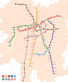
metro
The Metro de Santiago currently runs on five lines until 11 p.m. at the latest and is a reliable and clean means of transport. The trains and stations are modern, but they are often very busy, especially during rush hour. Lines 3 and 6 are operated fully automatically.
The following lines are in use (connections to other metro lines in italics in brackets):
- Line 1: San Pablo (L5) - Central Estacion (Metrotrene) - Los Heroes (L2) - Universidad de Chile (L3) - Baquedano (L5) - Los Leones (L6) - Tobalaba (L4) - Los Dominicos
- Line 2: Vespucio Norte - Puente Cal y Canto (L3) - Santa Ana (L5) - Los Heroes (L1) - Franklin (L6) - La Cisterna (L4A)
- Line 3: Los Libertadores - Puente Cal y Canto (L2) - Plaza de Armas (L5) - Universidad de Chile (L1) - Irarrázaval (L5) - Ñuñoa (L6) - Plaza Egaña (L4) - Fernando Castillo Velasco
- Line 4: Tobalaba (L1) - Plaza Egaña (L3) - Vicuña Mackenna (L4A) - Vicente Valdés (L5) - Plaza de Puente Alto
- Line 4A: La Cisterna (L2) - Vicuña Mackenna (L4)
- Line 5: Plaza de Maipú - San Pablo (L1) - Santa Ana (L2) - Plaza de Armas (L3) - Baquedano (L1) - Irarrázaval (L3) - Ñuble (L6) - Vicente Valdés (L4)
- Line 6: Cerrillos - Lo Valledor (Metrotrene) - Franklin (L2) - Ñuble (L5) - Ñuñoa (L3) - Los Leones (L1)
Further lines are being planned, for line 3 an extension to the Plaza de Quilicura station is planned.
A ride on the metro costs between 670 and 800 pesos, depending on the time of day (as of 2019) (within a period of 2 hours and including the option to change trains twice). The metro network is being systematically expanded. There are no daily, weekly or monthly tickets.
On lines 2, 4 and 5, the trains only serve about every second station (red trip (Estaciones Ruta Roja) and green trip (Estaciones Ruta Verde)) apart from the important transfer stations (Estaciones Comunes) during rush hour. The trains and the stations are each color-coded accordingly, it is important to pay attention to the signs in the driver's cab and the lights attached to the side of the train.
City buses
With the Transantiago The so-called bus system can be reached around the clock, almost every corner of the city. The network of routes is not always easy to see through for outsiders. The color of the buses used roughly indicates the city area served: green and white buses are on the way in the city center and connect two city districts. Orange and white buses run to the east of the city, for example. The route (metro stations and avenues used) can be seen at the stops and in the front window of the bus.
Metrotren Nos
The Metrotren Nos runs between the Estacion Central (Alameda train station) and the suburb of Nos, which runs to San Bernardo, but its tourist significance is likely to be of minor importance.
Tickets
The Bip! Card (Spanish "tarjeta bip!"), which works like an electronic wallet like the Oyster card in London. You can top up it at terminals in the metro stations and at larger bus stops and the money is withdrawn when you use the bus and metro.
Taxis
Both taxis and shared taxis (colectivos) serve the entire metropolitan region and are easy to recognize by their black car (taxis also have a yellow roof).
In the street
Getting around Santiago by vehicle is not strictly advisable. The road network is well developed, but traffic jams and chaotic situations often occur.
If you have to, the major avenues and city highways offer orientation:
- The Av. Libertador Bernardo O'Higgins (referred to as "Alameda") runs through Santiago von Providencia in the east to Pajaritos in the west of the city, where it merges into the CH-68 route towards Valparaíso. It is the broad main axis of the city, under it the metro line 1 runs.
- The Ruta CH-5 (Panamericana) is distributed within Santiago on two north-south routes. The main route runs as Autopista Central directly west of the city center, in its median are the tracks of metro line 2. Further to the west is the Av. Grail. Velásquez, which is connected to the Autopista Central in the north at El Cortijo and in the south at San Bernardo and takes the more direct route.
- The Ruta CH-70 forms a ring around the urban area (which is not developed without intersections in the east) and is called Autopista Vespucio Norte / Sur designated.
- The Av. Costanera Norte also runs in an east-west direction through the urban area and follows (partly in the tunnel) the course of the Río Mapocho. It connects the airport with the city center and binds the Northeast Santiago to the transport network.
- The Autopista Nororiente branches off the route CH-5 north of Quilicura and leads to Av. Costanera Norte in the area of Las Condes.
- The Acceso Sur branches off in the extreme south of Santiago from the Autopista Vespucio Sur and binds Puente Alto at.
The motorways are subject to tolls, in the Santiago area the toll is billed electronically ("day"). Rental cars are usually equipped with the appropriate transponders. The traffic rules generally correspond to the German ones and are usually taken seriously, but Chilean drivers are not necessarily known for their defensive driving style. The maximum speed in urban areas in Chile is now 50 km / h.
The numerous, often multi-lane one-way streets and the bus lanes that are not always clearly marked represent a particular challenge. The direction of the one-way streets can change during the day, depending on the traffic load.
An international driver's license is not required, but it can be helpful.
Tourist bus
- Tourism. Turistik offers a typical hop-on-hop-off bus that goes to most of the sights of Santiago. A tour costs $ 20,000 and takes about 2 hours if you don't get off the bus. Boarding at 9.30 a.m. at Plaza de Armas, Plaza de la Ciudadanía or Cerro Santa Lucía. There are audio guides in German.
Tourist Attractions
Although Santiago has been hit by several devastating earthquakes in the past, which destroyed almost all colonial buildings, you can find a variety of sights in the Chilean capital. From museums and galleries to palaces like La Moneda to the hills of Santa Lucía and San Cristóbal - Santiago has something for everyone.
Churches
Catedral Metropolitana

The cathedral of Santiago, completed in 1800, is the seat of the Archdiocese of Santiago and the most important place of worship in the country. The church, built in the neoclassical style, consists of a central nave and two side aisles. It also has a crypt which not only houses the graves of the former archbishops but also that of the former president Diego Portales. In addition, the cathedral impresses with its imposing marble altar and its large number of paintings and statues of saints. The marble comes from Bavaria.
- 1 Catedral Metropolitana de Santiago, Plaza de Armas n ° 444 (Metro: Plaza de Armas). Tel.: 56 2 26962777. Open: Daily from 9:30 a.m. to 10:00 p.m., Holy Mass on Saturdays at 12:30 p.m. and at 7:00 p.m., Sundays at 10:00 a.m., 11:00 a.m., 12:00 p.m. and 7:00 p.m. .Price: free entry.
Iglesia San Francisco

The baroque Iglesia San Francisco is the oldest surviving church in the city; It was consecrated as early as 1618 and served as a Franciscan monastery for centuries and is now home to it Museo de Arte Colonial, which has a considerable selection of paintings in need of restoration from the colonial era as well as a small garden in the inner courtyard.
Palaces
La Moneda


The Chilean government palace was opened as a mint in 1812 and is now the official seat of the president. It is the only building in the Italian-neoclassical style in South America and is now considered one of the most beautiful colonial buildings on the continent. It was largely destroyed during the military coup in 1973, has now been extensively restored and can now be viewed on a guided tour. Don't miss the daily changing of the guard on the south side of the palace.
The cultural center is located below the Moneda Centro Cultural Palacio de La Moneda with changing art exhibitions.
Buildings
Ex Congreso Nacional

The building, erected in 1857 in neoclassical style, housed the Chilean National Congress until 1973, which now meets in Valparaíso. Nevertheless, Santiago is undisputedly the political center of the Andean republic. The grounds of the former seat of the legislature also include a beautifully landscaped garden. However, public access is limited and the Palace of Justice is opposite.4 Ex Congreso Nacional Address: Compañía de Jesús 1131
Casa Colorada

The Casa Colorada in the immediate vicinity of the Plaza de Armas is one of the oldest still existing colonial houses in Santiago; the majority were destroyed in the course of time by the many earthquakes. Built in 1769, it served as a private residence and is now home to the Museo de Santiago, a smaller museum that tells the history of the city.
Gran Torre Costanera

The one also under the name Gran Torre Santiago famous skyscraper is the tallest building in all of Latin America at 300 meters. It rises from the Costanera Center shopping center and mainly houses offices. The Sky Costanera viewing platform, which opened in 2015 on floors 61 and 62, is very popular and offers a 360º view and, on a clear day, up to 50 kilometers of Santiago .
Museums
Museo Histórico Nacional

The National Museum of Chile is located in the historic building of the former Royal Court of Appeal on the Plaza de Armas. In 18 halls it shows an interesting permanent exhibition on the history of the country not only through imposing paintings, but also through antique furniture, clothing, weapons, everyday objects and curiosities such as the glasses of the former President Salvador Allende. Thus, the Museo Histórico Nacional has many collections of artifacts related to the history of Chile, from the colonial times to the present. On the other hand, the museum also shows temporary exhibitions on various topics and has its own library with a focus on history.
Museo de la Memoria y los Derechos Humanos
The recently opened Museum of Remembrance and Human Rights is dedicated to a very present topic: the dictatorship under Augusto Pinochet 1973-1990. In addition to the coup itself, it mainly shows life during the dictatorship, the suffering and the crimes committed, but also international solidarity and the road to democracy. The information is illustrated in a modern way using original documents such as clippings from television, radio or newspapers as well as personal items, photos and letters.
Museo Chileno de Arte Precolombino

The Museum of Pre-Columbian Art is one of the most important museums of Latin American cultures and shows a wide range of exhibits on the subject of the indigenous peoples of Latin America, Chile and the history of Chile before the Spanish conquest. The spectrum of exhibits ranges from wooden figures and vases to tools Mummies. Another attraction of the museum is the interactive Zona Mustakis, where children can get to know the pre-Columbian cultures in a playful way, as well as the changing temporary exhibitions. In addition, it offers a museum café and a museum shop.
Museo Nacional de Bellas Artes

Inside the baroque building in Parque Forestal is the National Museum of Fine Arts of Chile; it exhibits over 3000 paintings, statues and other artefacts of Chilean, Andean but also international (mainly Spanish) art.
La Chascona
La Chascona is one of three houses owned by the Chilean Nobel Prize for Literature, Pablo Neruda. It is named after the wild (quechua "chasqona") hair of his lover. You can see various collections of the poet and you don't have to be his biggest fan to enjoy this idyllic place.
Streets and squares
- Plaza de Dignidad (Plaza Italia) (At the metro station Baquedano, between Parque Forestal and Balmaceda). The Plaza der Dignidad, formerly Plaza Italia, is particularly popular because of the riots that began in October. It is located in the center at the METRO Baquedano station. It is a collection point at major events such as football games or protests.
Plaza de Armas

The 11 Plaza de Armas marks the center of the city of Santiago and forms a green oasis in the middle of an area predominantly populated by Peruvians. Already laid out in 1541 by city founder Pedro de Valdivia, whose equestrian statue now adorns the square, it is now lined with the cathedral, the main post office, the Palacio de la Real Audiencia and the town hall of Santiago. In addition, there is a bandstand, a memorial to the indigenous peoples of Chile, stalls, many benches, street performers and lots of pigeons on the lively square.
Plaza de la Ciudadanía

To the south of the Moneda extends the Citizenship Square, which is crossed in its center by the east-west axis Alameda. On the square, which is mostly covered with lawn, there are some water features and the 61-meter-tall Bandera Bicentenario, the Chilean flag with the highest mast ever. The Paseo Bulnes connects to the south.
Avenida Libertador Bernardo O'Higgins
The main traffic axis of Santiago, usually only called "Alameda", runs 8 kilometers from Plaza Baquedano through the city center until it turns into the Ruta CH-68 in the Pudahuel district Valparaíso transforms. It was laid out in the old river bed of the Río Mapocho in the colonial times, today it has mostly five lanes and lines a large number of important buildings such as the Estación Central, La Moneda, the Universidad de Chile, the Cerro Santa Lucía and the Iglesia San Francisco as well as over 30 monuments and memorials. Metro line 1 runs underground here.
Parks
Cerro San Cristóbal

.jpg/220px-Chile_-_Santiago_24_-_Virgin_Mary_statue_on_Cerro_San_Cristóbal_(6977789601).jpg)
The almost 300 meter high 12 Cerro San Cristóbal is a hill dominated by the Parque Metropolitano northeast of the city center. He is particularly known for the Santuario del Cerro San Cristóbal, a kind of open-air church in a garden on the highest point of the hill, which is a popular destination and a recognized place of pilgrimage. The Parque Metropolitano forms a green lung within the city and, with 722 hectares, is one of the most extensive inner-city parks in the world. The snow-white, fourteen-meter-high figure of the Virgin Mary marks the top of the hill and impresses with its spectacular view of the city area and on The Andes. Cerro San Cristóbal can be reached via the Funicular de Santiago funicular (valley station at Plaza Pío Nono in the trendy Barrio Bellavista, Round trip costs $ 2000 for adults and $ 1500 for children, on weekends $ 2600 or $ 1,950) or with the cable car Teleférico de Santiago, which was reopened in 2016 after extensive renovation. At its foot next to the valley station of the funicular is the zoo from Santiago.
Cerro Santa Lucía


The Cerro Santa Lucía is a 69 meter high hill and park in the heart of the city center. In 1541 Pedro de Valdivia founded the city of Santiago from what was then called "Huelén"; Today the green oasis impresses with several fountains, including the baroque Neptune fountain at the entrance, winding footpaths, historical cannons, monuments, subtropical planting and the Castillo Hidalgo, remains of a fortress on the top of the hill, from which one has a magnificent view of the surroundings .
The hill can be reached from the north (calle Merced, Metro Bellas Artes) as well as from the south (Alameda, Metro Santa Lucía).
Forestal Park
.JPG/220px-Parque_Forestal_(4).JPG)
In the city park, which was laid out on the banks of the Río Mapocho at the beginning of the 20th century, a large number of different tree species grow, including centenarian plane trees.
In addition to the Fuente Alemana fountain donated by the German Community of Chile, the well-maintained complex also houses the Palacio de Bellas Artes art museum and the cultural center in the former station hall, Estación Mapocho. In summer, the Parque Forestal near the city center is a popular place to picnic or to escape the hustle and bustle of the big city.
It can be reached via the metro stations Baquedano, Bellas Artes and Cal y Canto.
Cementerio General

The National Cemetery of Chile is a bit away from the center. Most of the former presidents as well as other important statesmen, scientists and artists rest on the grounds, which were laid out in 1821. The extensive area in the Recoleta district has hundreds of mausoleums, some of which are striking, and describes itself as an open-air museum. Neben privaten Gräbern finden sich auch einige Denkmäler, darunter jenes der unbekannten Opfer der Diktatur. Es werden verschiedene geführte Touren angeboten, darunter die bei Dunkelheit stattfindende Tour Nocturno. Auch wenn man die Namen der meisten Verstorbenen nicht kennt, der Besuch lohnt sich.
- Cementerio General, Av. Profesor Alberto Zañartu N.° 951, Recoleta (Metro: Cementerios). Tel.: 56 2 26377800, Email: [email protected].
activities
Events
- Jedes Jahr findet am Tag des Heeres, dem 19. September, im Parque O'Higgins eine Militärparade instead of
shop
Shopping centers
Costanera Center
Der moderne Shoppingkomplex erstreckt sich über 7 Ebenen und bietet neben einer Vielzahl von Einkaufs- und Essmöglichkeiten mit Filialen internationaler Geschäfte auch ein Kino und gilt eines der größten Einkaufszentren Südamerikas.
- 1 Mall Parque Arauro


 in der Datenbank Wikidata")

Markets
Mercado Central

Der Mercado Central ist eine 1872 aus Eisen errichtete Markthalle die heute neben dem eigentlichen Markt mit Obst- Gemüse aber auch Souvenirständen über 200 gastronomische Betriebe beherbergt, die meisten davon bieten frischen Fisch und Meeresfrüchte aus heimischen Gewässern sowie typisch chilenisch-kreolische Küche.
Handicrafts
- Centro Artesanal Santa Lucia, an der Alameda gegenüber der Nationalbibliothek.
- Centro Artesanal Los Dominicos, Avenida Apoquindo 9085, Local 35, Las Condes. Tel.: 56-2 211 1379. Hier gibt es die unterschiedlichsten Handarbeiten in einem kleinen Künstlerdorf.Geöffnet: Mo-So 10:30 bis 19:00.
Lapislazuli-Stein Lapis stammt aus dem Lateinischen und bedeutet „Stein“ und lazuli aus dem Arabischen und bedeutet „blau“. Tips
kitchen

Santiago bietet eine breite Auswahl an Möglichkeiten zu Essen. Abseits der klassischen Filialen von McDonalds, KFC und Co empfiehlt es sich, traditionelle chilenische Restaurants auszuprobieren.
- La Piojera. Eines der bekanntesten und traditionsreichsten Restaurants Chiles, bietet traditionelle chilenische Gerichte und den berühmten "Terremoto".
- El Galeón. Berühmtes Restaurant im Mercado Central, bietet vor allem Meeresfrüchte und Fisch.
- Barrica 94. Im Barrio Bellavista bietet eine große Auswahl an chilenischen Weinen und empfehlenswerte Menüs.
- La Mensajería. Hat sich auf chilenische Gerichte und insbesondere auf "Empanadas", mit allem möglichen gefüllte Teigtaschen, spezialisiert. Neben den Klassikern mit Rindfleisch oder mit Käse gibt es hier auch süße Empanadas oder solche mit Meeresfrüchten.
- Fuente Alemana, am Plaza Baquedano. Hier gibt es köstliche Sandwiches wie die "Completos".
- Gabriela. Im "Centro Cultural Gabriela Mistral" bietet einen Mix aus traditioneller chilenischer Küche und neuen experimentellen Elementen.
- El Galeón, Mercado Central, local 26 y 80, Mapocho. Tel.: 56 2 696 52 58, Email: [email protected]. gute Auswahl an Meeresfrüchten und Fisch.
- Donde Augusto, Calle San Pablo 967, Mercado Central. Tel.: 56 2 671 45 58, 56 2 698 13 66, Fax: 56 2 672 77 49, 56 2 696 80 69.
nightlife
Erste Anlaufstelle ist das Viertel Bellavista nördlich des Río Mapocho. Es lockt mit seinen bunten Bars und Kneipen, diese oft mit Live-Musik.
Ebenfalls einen Besuch wert ist das etwas ruhigere Barrio Italia (auch bei Tag empfehlenswert). In diesem finden man viele kleine Restaurants, vom Burger Laden, bis zu Sushi.
Wenn man Feiern möchte, kann man die Avenida Manuel Montt aufsuchen. In dieser warten Clubs und Restaurants.
accommodation
In Santiago gibt es für jeden Anspruch und jeden Geldbeutel eine passende Unterkunft. Im Osten der Stadt ist es im Schnitt gehobener und somit teurer.
- Hostal Rio Amazonas. Eine Backpackerunterkunft für Leute die eigentlich keine solchen mögen. Kreatives Design, großzügige Zimmer in verschiedenen Kategorien und freundliches Personal lassen den Aufenthalt zum Genuss werden.
- Happy House. Nahe von La Moneda bietet dieses 2-Sterne-Hotel verschiedene Kategorien von sauberen Zimmern.
- La Reve Hotel. Elegantes Hotel, 185 USD pro Nacht.
Anstelle eines Hostals bietet es sich durchaus an, ein Apartment zu mieten, von wo aus man sich selbst versorgen kann.
Learn
Language schools
- Chile Inside. Angeboten werden Sprachkurse, Praktika, Freiwilligenarbeit und mehr.
Universities

In Santiago ist der größte Teil der chilenischen Universitäten ansässig, darunter staatliche und private.
- Universidad de Chile. Die älteste und renommierteste Universität des Landes.
Um die Sprache zu lernen bzw. zu festigen empfiehlt sich ein Sprachkurs. The Goethe Institute bietet z.B. neben Deutschkursen auch gute Spanischkurse mit verschiedenen Niveaus an. Von dort lassen sich auch Tandempartnerschaften vermitteln, da dort Chilenen auch Deutschkurse besuchen.
Work
Es ist verhältnismäßig schwer, in Santiago eine Stelle zu finden.
security
crime
Chile ist das sicherste Land Südamerikas, dennoch ist insbesondere in den Großstädten und insbesondere in Santiago Vorsicht geboten. Zwar ist das Zentrum auch nachts tendenziell sicher, aber es wird empfohlen zu später Stunde lieber ein Taxi zu nehmen und nicht alleine unterwegs zu sein. Viertel wie Puente Alto sollte man bei Dunkelheit meiden.
Die Polizeipräsenz (Carabinieros de Chile) im Zentrum von Santiago ist vergleichsweise hoch.
Natural hazards
Bedingt durch seine Lage am Rand der Südamerikanischen Platte und der Nazca-Platte liegt Santiago in einer der erdbebengefährdesten Zonen der Erde. In der Vergangenheit verwüsteten zahlreiche Erdbeben immer wieder das Stadtgebiet. Heute verfügt Chile über eines der weltweit besten Vorwarnsysteme und seit Jahrzehnten wird sich beim Bauen auf Erdbebensicherheit konzentriert. Sollte man ein Erdbeben erleben, ist es ratsam, die here aufgelisteten Punkte zu beachten. Aufgrund seiner Höhe und seiner Entfernung vom Meer ist Santiago im Gegensatz zu den Küstenregionen des Landes nicht durch Tsunamis gefährdet.
health
Wasser das direkt aus dem offiziellen Leitungssystem der Stadt kommt hat Trinkwasserqualität, Vorsicht ist allerdings geboten bei nicht erhitzten ggf. mit Wasser zubereiteten Nahrungsmitteln bei mobilen Ständen.
Practical advice
Für Touristen ohne Spanischkenntnisse ist die Verständigung mit einheimischen Gesprächspartnern (z.B. in Einkaufszentren oder an Busbahnhöfen) schwierig, da selbst jüngere Chilenen nur selten Englisch sprechen.An der Plaza de Armas befindet sich das zentrale Postamt (Correos Chile).
Tourist Information
- Sernatur, Av. Libertador Bernardo O'Higgins 227 (Metro: Universidad Católica (Linie 1)). Tel.: 56 2 27318627, Email: [email protected]. Geöffnet: Öffnungszeiten: Mo 12.00 – 18.00 Uhr, Di 10.00 – 19.00 Uhr, Mi 10.00 – 18.00 Uhr, Do 10.00 – 19.00 Uhr, Fr 10.00 – 18.00 Uhr, Sa 10.00 – 14.00 Uhr.
Konsularische Vertretungen
trips
Cajón del Maipo
The Cajón del Maipo ist eine besonders bei Trekking- und Ökotouristen beliebte Schlucht in den Anden südöstlich von Santiago. Der Río Maipo bietet sich für Abenteuerlustige zum Kayakfahren und Raften an; die steilen Wege bieten beste Voraussetzungen für Mountainbiker. Wanderwege mit grandioser Aussicht (zum Beispiel zum Stausee El Yeso), adrenalines Canoping, entspannende Thermen und kleine traditionelle Dörfer wie San José de Maipo runden das Angebot ab.
Entfernung: ca. 50 Kilometer vom Zentrum, ab der Metrostation "Las Mercedes" per Colectivo weiter in die Schlucht.
Valle Nevado
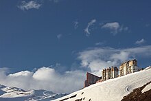
Auch in Südamerika kann man Skifahren! - Zum Beispiel im Valle Nevado oberhalb von der chilenischen Hauptstadt in den Anden. Die Saison dauert von Juni bis Ende September und bietet 35 Pisten in jedem Schwierigkeitsgrad auf insgesamt 37 Pistenkilometern. Egal ob einfaches Skifahren, Snowboard oder gar Skiakrobatik - das Valle Nevado bietet alles was das Skifahrerherz begehrt, darunter auch Unterbringungsmöglichkeiten von preiswerten Herbergen bis luxuriöse Lodgen. Beliebt ist das Skigebiet auch bei europäischen Skiprofis als sommerliches Trainingscamp.
Entfernung vom Stadtzentrum: ca. 60 Kilometer
Pomaire
The little village Pomaire ist berühmt für seine traditionelle Keramik. Neben hitzeresistenten Töpfen sind vor allem kleine Schweinchen ein beliebtes, glückverheißendes Mitbringsel; jedes Stück ist ein Unikat. Darüber hinaus bietet Pomaire viele gastronomische Betriebe, die überwiegend traditionelle chilenische Küche anbieten.
Entfernung: ca. 70 Kilometer
Weinanbaugebiete

Chile ist das Land des Weines. Besonders um die Region südlich von Santiago finden sich exzellente Bedingungen zum Anbau edler Tropfen. Der Weinbau hat hier Tradition! Viele Weingüter bieten Touren über ihre Ländereien und ihre Kellereien, selbstverständlich mit Weinprobe, an. Gradezu berüchtigt ist die Ruta del Vino, die chilenische Weinstraße. Darüber hinaus besteht die Möglichkeit seinen eigenen Wein zu kreieren. Empfohlen wird auch der "Tren del Vino", ein Touristenzug mit dem Themenschwerpunkt Weine des Valle Colchagua. Doch auch selbst organisierte Ausflüge zu Weingütern bieten sich an. Concha y Toro ist ein in Familienbesitz befindliches Weingut vor den Toren der Metropole.
Valparaíso and Viña del Mar
Die Hafenstadt Valparaíso und das benachbarte Seebad Viña del Mar gehören zu den bedeutendsten touristischen Zielen des Landes - sowohl für einheimische als auch für internationale Touristen. Während Valparaíso durch seinen unverwechselbaren Charme, seinen Flair und seine Geschichte punktet, lockt Viña del Mar mit seiner Strandpromenade und seinen vielen attraktiven Vergnügungsmöglichkeiten wie Casinos, Parks und Einkaufszentren.
Entfernung: ca. 120 Kilometer, erreichbar am besten mit dem Bus in weniger als 2 Stunden.
Sewell
.jpg/220px-Campamento_Minero_de_Sewell_(2).jpg)
Hoch und abgelegen in den Anden ragt die verlassene Minenstadt Sewell, aufgrund ihrer Höhenunterschiede auch "Stadt der Treppen" genannt, aus dem Schnee. Das heutige Museumsdorf steht unter UNESCO-Weltkulturerbe und ist ein Muss für all diejenigen die sich für Industriekultur interessieren, denn die ehemalige Industriestadt einer Kupfermine ist aufwendig renoviert worden und erstrahlt heute im neuen Glanz. Besichtbar sind sowohl die Stadt als auch Industrieanlagen und ein lohnendes Museum über den Kupferabbau Chiles, immernoch einer der Hauptwirtschaftszweige des Landes.Entfernung: ca. 150 Kilometer, Erreichbar von Rancagua out.
literature
Web links
- http://www.gobiernosantiago.cl – Offizielle Webseite von Santiago de Chile