The Easter island or Rapa Nui is the westernmost island of Chile and lies in Polynesia. Administratively it belongs to Región de Valparaíso, but it is more than 3,000 km away from the capital. Since 2007 it has had extensive autonomy vis-à-vis the central government.
Despite its small population and remote location, it is a popular travel destination, especially because of the sculptures created by the indigenous people centuries ago, the Moaiwhich can be found all over the island.
places
The only notable place is Hanga Roa, the capital of the island, located in the southwest with about 5,000 inhabitants. There are only a few individual huts spread across the island, some of which are uninhabited.
background


Easter Island occupies a special position in Chile, as it has always been inhabited by Polynesian peoples who are more close to the other island states and territories such as Tahiti felt belonging.
history
Today's Poike Peninsula in the north was created about 3 million years ago by a volcanic eruption. After another 2 million years, Rano Kau rose from the sea in the southwest and, 250,000 years ago, Maunga Terevaka combined the two volcanoes to form an island. It is believed that the first settlers reached the island between 300 and 500 AD. However, there is no historical evidence of this as all oral traditions do not begin until the arrival of Hotu Matu'a around AD 1350. According to legend, his adviser Hau-Maka is said to have had a dream in which his spirit traveled to a large fertile island in the east. When Hotu-Matu'a heard of the dream, he commissioned seven men to find the island. Upon their return, a large part of the Hotu-Matu'a tribe left the island of Hiva in Polynesia and sailed east. It is assumed that Hiva belonged to the Marquesas Islands in Polynesia, but today it is no longer possible to determine which island it was.
Since Easter Island was already inhabited, disputes arose over the fertile farmland after a while. Hotu-Matu'a's descendants enslaved the previous residents. As slave labor got tougher, there was finally a slave revolt in 1680.
On April 6, 1722, an Easter Sunday, the island was "discovered" by the Dutchman Jacob Roggeveen. During the colonial period, the island was visited several times by Europeans, but not yet taken possession of.
Between 1850 and 1870 there was an invasion of illegal slave traders on the island, who kidnapped many of the inhabitants to Peru and had them work in the guano fields there. Out of 1,000 slaves, 900 died in one year. The Bishop of Tahiti campaigned for the last 100 survivors to be returned to the island. However, since many were infected with smallpox, most died during the crossing and the few survivors also infected the rest of the island's population, so that in 1877 only 111 islanders lived on the island.
In 1888, the Chilean captain Policarpo Toro annexed the island for Chile, so that the island was incorporated into the country.
Until well into the 20th century, the inhabitants of the islands were second-class Chilean citizens; they did not acquire full citizenship until 1966. In addition, the island was isolated from the rest of Chile for a long time. Almost the entire island has been leased to foreign companies for intensive livestock farming. The islanders were only allowed to stay in a very small part of the island. In 1967 the islanders obtained extensive concessions and a regular flight to Santiago. Nevertheless, the relationship remained tense, as the Rapanui resisted the establishment of private property in the 1970s; their laws, on the other hand, proceeded from collective property.
It was only after Chile's transition to democracy in 1986 that the island began to develop in earnest. In 1990 a commission was set up to develop the island. Nevertheless, the government continued to deny the island the desired autonomy, which led to it threatening a unilateral declaration of independence in 2006. In 2007 Chile gave in and handed over Easter Island and the Juan Fernández Islands a special status as autonomous regions.
language

The language is called Rapanui by the locals. It is of Polynesian origin, but has changed significantly over the centuries due to the isolation of Easter Island, so that today only a few words correspond to other Polynesian languages. The locals find it easier to learn the Tahitian language than Spanish. Many only really learn Spanish in school and still consider it a foreign language. Many residents who are active in tourism speak more or less good English. Advertising for events is often also in French, rarely in German.
mobility
Arriving by plane is only possible with the Chilean LAN. There are daily connections to IPC (Isla de Pascua) from Santiago de Chile, and 1 to 2 times a week from / to Papeete (Tahiti) and depending on the season Lima (Peru).
Every now and then a cruise ship comes by, but then stays in the roadstead at a reasonable distance and brings its passengers to the small harbor basin in individual tender boats. But this can be a very special experience even in moderate swell.
On the island there are neither those typical for the Chilean mainland Micro-Buses still Colectivos. Instead, numerous taxi drivers vie for the attention of tourists in the village. However, it is only a 20-minute walk from the airport to the center of Hanga Roa.
In order to get to know the different sights of the island, it is advisable to rent a bicycle (13 euros per 24 hours) or a jeep (approx. 50 euros per 24 hours). There are numerous landlords in the center of Hanga Roa. Closer destinations (Rano Kau, Tere Vaka, Ahu Akiwi) can also be easily reached on foot. Many companies also offer guided tours around the island in minibuses.
A return trip to Anakena Beach costs around 15 euros by taxi, which is very expensive for a 2x30 minute drive, but the only way to get there is by motorized vehicle.
Tourist Attractions
- 1 Rano Kau, at the southern tip of the island. Extinct volcanic crater with subtropical vegetation, 1600 m diameter.
- 2 Orongo. Former and restored cult site on the Rano Kau.
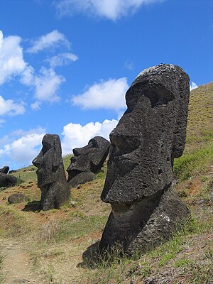
- 3 Rano Raraku. Slightly smaller volcanic crater, but of great importance because the Moais carved out of the rock and transported from there in all directions.
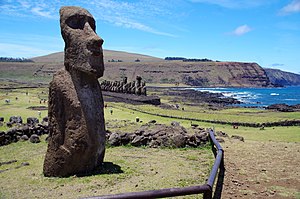
- 4 Ahu Tongariki. Like the Rano Raraku in the southeast of the island, a cult site with 15 standing moais.
- 5 Mount Tere Vaka. Another extinct volcano, highest point on the island (511 m) with a good view.
- 6 Poike, in the far east. The third extinct volcano, there is also the smallest Moai (1.13 m high).
- 7 Ahu Akiwi. Place of worship between Hanga Roa and Tere Vaka with 5 very well-preserved moais (standing).
- 8 Anakena South Seas Beach, located on the north coast. With coconut palms, white sand, right next to 2 ahus (former places of worship).
- 9 Iglesia Santa Cruz. Church in which Catholicism and Rapanui tradition merge (chants, sculptures) - every Sunday at 10 a.m. there is a service, which is definitely worth visiting.
There are also numerous places of worship and cave paintings that can be visited.
activities

- Hiking especially in the slightly cooler (20 degrees) winter, on the trail of the varied and interesting culture and history of the Rapanui
- Diving with various companies, including coral reefs
- guided tours around the island
- Riding tours in different areas
- Bathing and sunbathing on the only beach Anakena (bathing is only allowed there!)
- Surfing in the numerous bays (beware of reefs)
kitchen

In general, very high prices must be expected compared to South America, which is due to the island's isolated location. There are mainly fish dishes, which are often prepared the Polynesian way, but the Chilean empanadas are also widespread. Sweet potatoes, avocados, guavas, and bananas are among the plants that thrive on the island and are used in many dishes. Po'e - a kind of banana sponge cake - is offered at many stands. The only brewery on the island sells and exports its products under the name "Mahina".
nightlife
"Island-typical" shows for tourists, mostly on Saturdays, Mondays and Thursdays. Numerous bars and a disco in the village center.
accommodation
In Hanga Roa There are numerous accommodations from 25 euros per person per night (almost open scale towards the top). The only campsite on the island is also there (a little south of the center on the coast). Otherwise, camping is prohibited in the entire area of the island for outsiders, including at Anakena. In order to camp cheaper or on private property, you should know the locals well personally.
climate
The climate is oceanic and mild and relatively dry. Almost all year round, temperatures range between 12 (at night in winter) and 30 degrees. The water temperature remains consistently above 18 degrees.
literature
- Heyerdahl, Thor: Aku Aku The Secret of Easter Island, Berlin, Ullstein, 1957.
- Heyerdahl, Thor: The Art of Easter Island. Secrets and riddles. Munich-Gütersloh-Vienna, Bertelsmann, 1975.
- Machowski, Jacek: Island of Secrets. The discovery and exploration of Easter Island. Leipzig VEB F.A. Brockhaus Verlag 1968
- Helfritz, Hans: Easter Island. Zurich, Fretz & Wasmuth Verlag, 1953.
Web links
- Easter Island Foundation [1]