| Monte Rosa | |
 | |
| State | Italy Switzerland |
|---|---|
| Region | Valle d'Aosta Piedmont Valais |
| Mountain range | Alps |
| Height | 4,634 m a.s.l. |
Monte Rosa is located betweenItaly (on the border between Valle d'Aosta is Piedmont) and the Switzerland.
To know
Geographical notes
Located in the Pennine Alps and spread over Italian and Swiss territory, it is particularly famous for its east face, or the slope of Macugnaga, the highest prominent face in the Alps and the only one of Himalayan dimensions. Other notable slopes are the so-called Valsesian wall of Monte Rosa, which overlooks Alagna Valsesia, and the northern Swiss side, rich in imposing glaciers (Gornergletscher).
Punta Dufour, with its 4,634 meters, is the highest peak of the group, visible among all the surrounding villages only from the town of Macugnaga, named in homage to the Swiss General and great cartographer Guillaume-Henri Dufour (1787 - 1875). On the Punta Gnifetti there is the highest alpine refuge in Europe, the Capanna Regina Margherita (at an altitude of 4,554 meters), also home to a meteorological station and research center on the effects of high altitude on the human body.
The massif is widely visible from a relatively large part of the Po Valley.
Background
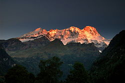
Although it is very romantic to think that the name derives from the pink color that the mountain takes at dawn or at sunset, the name Rosa derives from the Valle d'Aosta term rouése or rouja which means "glacier".
The high passes of the massif were already crossed in ancient times. It is thought that the Walser in the thirteenth century passed through the Colle del Lys to migrate from Valais to Lys Valley and toOssola.
The climbs to the various peaks of the massif took place in the 19th century, generally starting from the Italian side which was and is the easiest side:
- 1778 - The mountaineers of Gressoney-Saint-Jean, Valentino and Joseph Beck, Joseph Zumstein, Nicolas Vincent, Sebastian Linty, Étienne Lisco and François Castel reach the Rock of the Discovery.
- August 9, 1842 - Giovanni Gnifetti, parish priest of Alagna Valsesia, Giuseppe Farinetti, Cristoforo Ferraris, Cristoforo Grober, brothers Giovanni, Giacobbe Giordani, reach Punta Gnifetti with 2 other people.
- August 1, 1855 - John Birbeck, Charles Hudson, Ulrich Lauener, Christopher Smyth, James G. Smyth, Edward Stephenson, Matthäus Zumtaugwald and Johannes Zumtaugwald reach Punta Dufour (the highest peak in the massif).
- July 31, 1889 - Achille Ratti (future w: Pope Pius XI) reaches the top passing through the eastern part for the first time.
Territories and tourist destinations
Numerous valleys extend from Monte Rosa.
In Italy:
- Val d'Ayas (AO)
- Lys Valley (AO)
- Valsesia (VC)
- Anzasca Valley (VB), lateral of the Ossola Valley
In Switzerland:
Urban centers

- 1 Alagna Valsesia (Im Land in Walser; Lagna in Valsesian dialect) - In Valsesia.
- 2 Champoluc (Ayâs in Aosta Valley patois; Ajats in Walser) - In Val d'Ayas.
- 3 Gressoney-La-Trinité (Greschòney Drifaltigkeit in Walser; Gressonèy-La-Trinità in Franco-Provençal) - In Lys Valley.
- 4 Macugnaga (Macügnàga in the Ossola dialect, Makanà in the Walser language) - In Anzasca Valley.
- 5 Saas-Almagell - In Saastal.
- 6 Zermatt - In Mattertal.
Other destinations
- 1 Punta Dufour (4,634 m a.s.l.) - Highest peak of the Monte Rosa massif.
How to get
By plane
The closest airports are, on the Italian side, those of Milan-Malpensa, Turin-Caselle, while on the Swiss side the Sion Airport.
By car
Piedmontese side:
- A26 motorway: from Genoa towards Gravellona Toce. Romagnano Ghemme exit for Valsesia; Piedimulera exit for Macugnaga.
- A8 motorway: from Milan towards Varese. Gallarate-Gattico branch, entrance to A26. Romagnano Ghemme exit for Valsesia; Piedimulera exit for Macugnaga.
Valle d'Aosta side:
- A5 motorway: from Turin direction Aosta-Mont Blanc. Pont-Saint-Martin and Verrès exit respectively for the Lys Valley and the Val d'Ayas.
Swiss side:
- From Geneva: A9 towards Brig.
- From Basel is Lamp: A2 direction Chiasso, Göschenen exit. Then take the main road 19 towards Brig.
- From Brig you reach the Saas and Matter valleys.
How to get around
Monte Rosa does not have car connections that allow you to connect the Swiss side to the Italian one, but neither does the Piedmontese side to the Valle d'Aosta one, either by means of passes or by means of tunnels. To pass from the Swiss valleys of Monte Rosa to the Italian ones, or vice versa, it is necessary to pass through the Simplon Pass or the San Bernardo tunnel.
What see
What to do

- Ski. All the villages close to the majestic walls of the mountain offer excellent proposals for winter tourism with alpine and cross-country skiing. The most important area is undoubtedly the MonterosaSki which with its 180 km of slopes connects three valleys: Val d'Ayas, Valle del Lys and Valsesia.
- Excursions. The most popular excursions, and also the easiest ones, are those that, starting from the inhabited centers, quickly reach the main mountain refuges from which you can enjoy splendid views. The more experienced can follow more demanding itineraries, which touch more refuges, such as, for example, the Monte Rosa tour or even tackle climbs that reach the spectacular peaks.
- 1 Gornergrat railway. A suggestive rack railway which, starting from Zermatt, reaches the magnificent Gorner glacier.
Shopping
Where to eat
Where stay

Italy
- Rifugio Ristorante Zamboni Zappa, Alpe Pedriola, Macugnaga, ☎ 39 032465313. Altitude 2070 m. At the base of the splendid east face of Monte Rosa it is located in a green basin just above the Belvedere glacier.
- Rifugio Ristorante Oberto Maroli, Monte Moro, Macugnaga, ☎ 39 032465544. Altitude 2868 m. Located on the Monte Moro pass, it can be reached by cable car from Macugnaga and is a starting point for descending into the Saastal.
- City of Mantua Refuge (Gressoney-La-Trinité), ☎ 39 0163 78150. Altitude 3.497 m. The refuge, comfortable for the altitude, was reopened in 1974 and extensively renovated in 2009.
- Giovanni Gnifetti hut (Gressoney-La-Trinité), ☎ 39 0163 024610. Altitude 3.647 m. The hut is an important base for accessing Monte Rosa from the south side.
- Quintino Sella Refuge, Felik Glacier, Gressoney-La-Trinité, ☎ 39 0125 366113. Altitude 3.585 m. The new and comfortable refuge was opened on August 29, 1981: since then the old refuge from 1885 has been transformed into a winter hall.
- Regina Margherita Refuge, Punta Gnifetti, Alagna Valsesia, ☎ 39 0163 024610.
 Half board: € 100. Altitude 4554 m. Guarded only in summer; room with 12 beds, gas for kitchen use. It is the highest refuge in Europe and excellent mountaineering preparation is required to reach it. Located in an exposed position, it has the highest panoramic balcony in Europe directly above the eastern face of Monte Rosa, almost 2,500 m high.
Switzerland
- Neue Monte Rosa-Hütte, Bergkristall, Zermatt, ☎ 41 27967 21 15. Altitude 2.883 m. Since 2010, the new Monte Rosa hut has replaced the "old" hut, which has since been demolished. The project for the ultramodern huts ("eco-UFO") comes from the Department of Architecture of the ETH of Zurich.
- Gandegghütte, Riedweg, Zermatt, ☎ 41 079 607 88 68. Altitude 3029 m. The hut was originally built in 1885 as a primitive food depot and emergency station, today it is an important tourist hub.
Safety
How to keep in touch
Around
Other projects
 Wikipedia contains an entry concerning Monte Rosa
 Commons contains images or other files on Monte Rosa