
The visit of National parks in Namibia is certainly a highlight of any trip to this South African country. However, they can only be reached with your own vehicle or on a tour. The protected areas are all administered by the state Namibia wildlife resorts (NWR). Their central information center has their office in Windhoek Zoo Park and a branch in Swakopmund.
NWR, as a state enterprise dem Ministry of Environment and Tourism subordinate, also operates a hotel chain with almost 1000 employees. In both 2005 and 2010 this was in financial difficulties. Massive discounts are traditionally granted every March.
It is forbidden to leave the roads when driving through national parks. Driving to the parks in the Caprivi Strip can be difficult during the rainy season (Nov.-Apr.). At this time of the year, the wild animals are also more spread out.
Flora and fauna
The poaching of elephants and rhinos could be restricted through increased controls in 2017/8. In the country you can see the “Big 5” (elephant, lion, leopard, buffalo as well as white and black rhinoceros), so valued by safari fans. There are also various species of antelope and gazelle.
It is not uncommon to see animals looking like large rats in rocky terrain, the that she (“Rock hyrax”), but taxonomically they are close to elephants.
Among the succulents there are numerous Spurge family common in all semi-arid regions.
accommodation
Either in lodges, which range in price from medium to luxurious, or camping, which is particularly suitable for self-drivers and is often possible on the premises of hotels. It is important to have a fence to keep animals away. Reservations several months in advance are strongly recommended during the dry season (i.e. high season) from May to September, some camps only have space for ten vehicles. A parking space for one car and three people will not cost more than N $ 400 in 2018. Meat and firewood are often sold for grilling, other supplies should be carried with you.
fees
_(32043273750).jpg/220px-Grey_Duiker_(Sylvicapra_grimmia)_(32043273750).jpg)

.jpg/220px-Tragelaphus_strepsiceros_(female).jpg)
.jpg/220px-Tragelaphus_strepsiceros_♂_(head).jpg)

For entering national parks, fees are charged per vehicle and person. Foreigners pay at least five times as much. There are two price categories (as of 2019):
- ) Locals N $ 50, foreigners N $ 250, car N $ 50: for Etosha Park, Fish River Canyon with Ai-Ais & Hobas, Skeleton Coast Park, Naukluft Park with Sesriem & Sossusvlei and Waterberg Plateau Park:
- ) Local N $ 30, Foreign N $ 200, Car N $ 10: Bwabwata National Park, Mudumu National Park, Khaudum National Park, Nkasa Rupara National Park, Mangetti National Park, Popa Falls Game Park, Daan Viljoen Game Park, Hardap Game Park , Naute Game Park, Von Bach Game Park.
The Permit for the Namib-Naukluft Park (Welwitschia Drive and the campsites at Bloedkoppie, Tinkas and Hobas) must be signed in advance NWR in Windhoek, NWR Swakopmund or at the campsite in Sesriem.
health
Heat stroke and dehydration, like sunburn, are always a danger in open terrain. A Arafat cloth around the head protects against scorching sun and dust at the same time. Who z. B. takes high quality cameras with you, should bring appropriate equipment for cleaning.
Deer crossing poses a real danger in the twilight. More people die every year from clashes with kudu than from crocodiles. Scorpio bites aren't fatal, but they can be very painful. Therefore, always shake out shoes that have been left overnight before putting them on.
If you are traveling in the north you should keep in mind that hippos and buffalo can become very aggressive. The former cause most of the deaths from wildlife in Africa.
National parks
Have their own main articles:
- Etosha National Park
- Fish River Canyon
- Kgalagadi Transfrontier National Park
- Skeleton coast and Cape of cross
Bwabwata National Park


.jpg/220px-Merops_pusillus_(28018143010).jpg)
By merging the Mahongo- and Caprivi-National parks protected area created in 2007 in the western Caprivi Strip. Its expansion is part of a proposal submitted in 2016 to expand the World Heritage site Okavango Delta. Of particular importance is the riverside forest on the section along the Okavango. Crocodiles and hippos can be found in the rivers. The middle part of the park is covered with deciduous forests, to the east the terrain slopes down into the drier plain of the Kwando, where a floodplain with reed islands joins the savannah. Elephants roam the area in unusually large herds.
The rapids of the 1 Popa Falls(18 ° 7 ′ 0 ″ S21 ° 35 ′ 0 ″ E) are a small protected area. During the high altitude of the Okavango between February and April, the rapids are practically completely flooded, but in the dry season the rock bar is largely exposed.
- Directions
The park is cut through by the Trans-Caprivi-Highway.
Diamond Restricted Area

More and more parts of the Tsau / Khaeb (restricted area) national parks around Luderitz have been released since 2008-12.[1]Oranjemund, which until 2011 was privately owned by NAMDEB was, can be visited by strangers without special permission since October 2017.
Industrial diamond mining has changed parts of the landscape, in others the cordon has meant that nature has remained untouched. Areas of the mouth of the Orange River, which forms the border with South Africa, are protected as wetlands under the Ramsar Convention. 2439 endemic plant species have been counted in the 260,000 km² exclusion zone, ninety percent of which has been a protected area since 2008.
Licensed operators, who also take care of the police entry permit, offer tours e.g. in the north to the ghost towns 1 Bogenfels(27 ° 28 ′ 0 ″ S15 ° 25 ′ 9 ″ E), 2 Ponoma(27 ° 11 ′ 35 ″ S15 ° 18 ′ 6 ″ E) and 3 Elizabeth Bay(26 ° 54 ′ 36 ″ S15 ° 11 '8 "E) where you can also see an active mine. In the 19th century in Märchental, diamonds were simply collected in the moonlight.
A limited number of escorted convoys are allowed to travel between Sylvia Hill and Sandwich Harbor on the coast. Self-drivers need all-wheel drive.
- Directions
Tour operators operate mainly from Lüderitz.
From South Africa 1 Border bridge over the Oranje(28 ° 34 ′ 6 ″ S16 ° 30 ′ 21 ″ E) between Alexander Bay (RSA) and Oranjemund (diamond restricted area). There are also landing sites at both villages.
The road from Rosh Pinar / Sendelingsdrif to Oranjemund was paved from 2014.
Dorob National Park
.jpg/220px-Damara_Tern_(8077271589).jpg)
The Dorob National Park, designated in 2010, closed the gap between the Namib-Naukluft National Park in the south and the Skeleton Coast National Park in the north, so that almost the entire coast is protected. A strip about 200 km long and 50 km wide on the C34 was already earlier than National West Coast (Tourist) Recreation Area expelled. The small town can be reached on the street 4 Henties Bay (Henties Bay)(22 ° 7 ′ 12 ″ S14 ° 16 '48 "E) a popular seaside resort.
This closes a little further behind the coast Mt Brandberg Nature Reserve at.
Khaudum National Park

The 4,000 km² park south of the Caprivi Strip on the border with Botswana, which consists mainly of dry forests, was earlier Game Reserve, i.e. visitors come mainly to see big game. Because of its remoteness, the park is hardly developed for tourists.
- Directions and accommodation
Access is only possible with all-wheel drive vehicles and in convoy over deep sandy slopes.
The 1 Xaudum Lodge(18 ° 55 ′ 38 ″ S20 ° 58 ′ 45 ″ E) and two campsites.
Mangetti National Park
A wildlife park that had been used for a long time to raise rhinos was upgraded to a national park in 2008 and has been accessible during the day since 2014. The landscape is dominated by Kalahari Sandveld and savannah. In addition to elephants, eland, kudu and giraffes, there are also sable antelopes and hyenas, leopards and lions and some of the last wild dogs.
The surrounding Mangetti Block region is parceled out into cattle ranches that run through the north to the north Veterinary fence be shielded against the introduction of rinderpest.
- Directions
On the national road B8 about a hundred kilometers south of Rundu.
Mudumu National Park

The 1010 km² park on the Kwando is an area to roam about, especially for herds of elephants. Otherwise, other large game such as water buffalo, giraffes, hippos and predators. Arrival: Tarred road from Rundu approx. 430 km or from Kasane approx. 250 km.
The region is prone to malaria all year round.
- accommodation
Water, food and fuel must be brought into the remote park. Supply in Kongola about 25 km from the park
- Campsite: Nakatwa Camp very easy
- Two private lodges Lianshulu along the river
about 15 km from the park, comfortable Gondwana Namushasha Lodge.
Namib-Naukluft National Park
.jpg/220px-Namib-Naukluft_National_Park_(above_Namib_Desert_Lodge).jpg)


.jpg/220px-Welwitschia,_Namib_(3095567371).jpg)


This park, between the Walvis Bay and Luderitz one visits less for its wildlife than for the landscape. With almost 50,000 km² it is larger than Lower Saxony.
The area can be roughly divided into five zones: The northern zone between the Kuiseb and Swakops rivers, with its rock formations and island mountains. At Kuiseb, e.g. at 2 Goababe(23 ° 33 ′ 42 ″ S15 ° 2 '49 "E) fluorescent scorpions can be observed at night. The starry skies are impressive thanks to the slightest Light pollution.
Not far from 2 Goanikontes Oasis Rest Camp(22 ° 39 ′ 50 ″ S14 ° 48 '54 "E) is the Lunar landscape and the 3 Welwitschia Plain(22 ° 40 ′ 9 ″ S15 ° 1 '42 "E) with probably the slowest growing plants in the world. Three of the largest uranium mines in the world, the Rössing mine, the Husab mine and Trekkopje, are also located in this region. The element lies above all in the strongly radiating form of Boltwoodite crystals in front.
The middle area with the eighty million year old desert areas, the 4 Sesriem Canyon(24 ° 31 ′ 9 ″ S15 ° 47 '26 "E) and the highest dunes in the world in Sossusvlei. The 5 Naukluft(24 ° 15 ′ 47 ″ S16 ° 14 ′ 20 ″ E) a zebra park, 120 km from Sesriem with rich wildlife, with the Kuiseb Canyon. The western section with archaic plants, bird sanctuaries at Walvis Bay and Sandwich Harbor.
If you want to combine Sossusvlei, Deadvlei and the Namib-Naukluft Trail, you should take five days.
Heading south is worth a detour to 6 Duwisib Castle(25 ° 15 ′ 26 ″ S16 ° 32 ′ 29 ″ E), with correspondingly more luxurious Guest farm. Also worth seeing are the dunes 1 Sandwich Bay(23 ° 22 ′ 49 ″ S14 ° 29 ′ 20 ″ E), for the route from Walvis Bay you need all-wheel drive and a licensed guide.
- Directions
From Windhoek it is a good 200 km, depending on the entry point. A permit is required. Stay is only permitted during the day. Most of the streets in the park require a four-wheel drive vehicle; also to reach Sandwich Bay towards the diamond restricted area. Sossusvlei, whose dunes it makes sense to visit in the morning to avoid the heat of the day, can be reached with normal drive.


- accommodation
The campsites, which are mainly located in the north of the park, are rudimentary. On the edge of the park there are more lodges and campsites of various categories.
- 3 Camping Mirabib
- 4 Tsondab Valley Lodge. Tel.: 264 81 128 3266. 5 bungalows. With camping. In the private Scenic Reserve.
- 5 Naukluft Camp (NWR). Tel.: 264 63 683 791. Chalets and campground. Starting point of the Waterkluf Trail, 17 km day hike.
Sesriem (accessible via D826):
- 6 Sesriem Campsite (NWR). Tel.: 27 13 751 2220.
- Desert Camp
- Desert Quiver Camp
- Sossus Oasis Camp Site
- Sosousvlei Lodge, 4*
- Sossus Dune Lodge, simple wooden huts, pool
- 7 Hauchabfontein Camping Area, Farm Hauchabfontein, Road D 854, Sesriem.
Out on the B4 (direction Lüderitz):
- Klein-Aus Vista Desert Horse. Tel.: 264 63 258 116. Belongs to Gondwana, the 3 km further also the Eagles Nest Chalets 3 * operate.
- 8 From Accommodation & Namib Garage Camping, Lüderitz Street Erf 52, Aus.
- Bahnhofhotel, Aus, 3 *
Nkasa-Rupara National Park
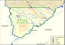
This 320 km² park is the largest wetland in Namibia in the central southern corner of the Caprivi Strip. The area was called until a few years ago Mamili National Park. There are a few small islands in the Kwando that can be reached on foot during the dry season.
- getting there
By car from the border crossing from Zambia in 2 Katima Mulilo(17 ° 28 ′ 40 ″ S24 ° 14 ′ 47 ″ E)where there is also an airfield.
Waterberg
The Waterberg is an approximately 50 ⨉ 16 km large table mountain. The 405 km² Waterberg Plateau Park was established in 1972 to protect the Elan antelope. The last Cape Vultures of Namibia also lived here, but they probably became extinct in 2014. Through resettlement, white and black rhinos have been made at home here. In total there are ninety species of mammals and almost five hundred plant species.
From the 9 Waterberg Camp(20 ° 30 ′ 59 ″ S17 ° 14 '43 "E) you have to go up the mountain with a guide who can be booked with NWR. Four-hour courses are also offered every day game spotting-Tours. Also the 3-day hikes on the Waterberg Trail you have to book here (preferably in advance).
- accommodation
Not far from Waterberg Camp are:
- Waterberg Andersson Camp
- Waterberg Plateau Lodge (not a bargain); with a separate campsite.
- Waterberg Valley Lodge
- Waterber Wilderness Lodge (Luxury)
Protected areas
The Daan Viljoen Game Park is near Windhoek.
Ais-Richtersveld Transfrontier Park


The most beautiful part of the park, which is mainly a stone desert, is the Fish River Canyon. The part of the Richtersveld cultural landscape in South Africa is part of the world natural heritage.
- getting there
The national park in the north (Fish River Canyon) is only accessible via the eastern side. Via the B1 and the C10 to Ai-Ais or the C12 and C37 to Hobas.
The private nature reserves are located on the western side of the canyon and can be reached from Keetmanshoop or Lüderitz via the B4 and D463.
From the border post at 3 Vioolsdrift(28 ° 45 ′ 57 ″ S17 ° 37 ′ 34 "E) the C13 crosses 55 km on the Namibian side 6 Exterior sweeping(28 ° 21 ′ 30 ″ S17 ° 24 ′ 35 ″ E) through the park 89 km after 7 Sendelingsdrif(28 ° 6 ′ 0 ″ S16 ° 52 ′ 42 "E) (here you can take a ferry to the South African town of the same name) and from there to Aus (193 km).
On the Vogelstrausskluft and near Grünau and Seeheim there are small landing areas for private or safari charter flights.
- accommodation
- 10 Vogelstrausskluft Private Nature Reserve(26 ° 57 ′ 57 ″ S17 ° 31 '15 "E), including the 2 * -Lodge (☎ 27 79 508 1818) on the lake.
Cape Cross Seal Reserve
The seal sanctuary on Cape of cross is part of the Skeleton Coast.
Hardap Game Park
The Hardap Recreation Resort The fishing lake at Hardap Dam at Fish River Canyon is 15 miles from 8 Mariental(24 ° 37 ′ 42 ″ S17 ° 57 ′ 20 ″ E). Signposted are hiking trails, one with 9 km, another with 15 km.
There is that on the lakeshore Hardap Recreation Response (NWR), bungalows and camping site.
Quiver Tree Forest
A few kilometers northeast of Keetmannshoop, the area is a “national monument” under nature protection. The five meter high aloes of the "Quiver Tree Forest" are located on the grounds of the Farm Gariganus at the fork of the M29 and C17.
Adjacent is the bizarre rocky landscape "playground of the giants," a 5 km² textbook example of block weathering and Desert varnish.
The owners of the farm run an expensive rest camp.
Naute Game Park

The park is a 230 km² wildlife sanctuary, especially for the antelope species springbok, kudu and duiker 8 Naute dam(26 ° 55 ′ 53 ″ S17 ° 56 ′ 18 ″ E). Some 600 hectares south of the dam are designated as a recreation area. The quiver trees in the region are worth seeing.
It is approached from Keetmanshoop, about sixty kilometers.
From Bach
Staying at the Recreation Resort / Game Park in this 43 km² area around the 9 From Bach reservoir(22 ° 0 ′ 15 ″ S16 ° 58 ′ 11 ″ E) is only allowed during the day, dogs are not allowed. Fishing licenses can be bought at the entrance.
- getting there
over 9 Okahandja(21 ° 58 ′ 43 ″ S16 ° 54 ′ 51 ″ E), which can be reached on the B1 71 km north of Windhoek. There is a campsite (King's Highway Rest Camp) as well as four simple and one luxurious accommodations in town.
Private protected areas
Some of the Namibian farmers have their spacious estates, originally mostly used for cattle breeding, for private use Game reserves transformed. These can be protected areas or hunting zones, in which shooting is possible for a high fee. For the latter in particular, there are specialized agencies that also take care of the relevant papers, guides and trophy preparation.
Gondwana Collection
Gondwana Collection is a private company that, since it was founded in 1995, has set up upscale accommodations in its own and at state parks, the more important of which are:
- Gondwana Cañon Park, established in 1995, 1260 km²; at the Fish River Canyon
- Gondwana Kalahari Park, founded in 2004, 100 km²; northeast of Mariental
- Gondwana Sperrgebiet Rand Park, established in 2004, 510 km²; at off
- Gondwana Namib Park, founded in 2004, 100 km²; north of Sesriem
State parks operated a further seventeen lodges (2017).
literature
See also the general Travel guide to South West Africa.
- Bridgeford, P .; Bridgeford, M .; Cape Cross: past and present; Walvis Bay 2002
- Butchart, Duncan; Wild about the Okavango: all-in-one guide to common animals & plants of the Okavango Delta, Chobe National Park and Caprivi Strip; Sandton 1999 (Wilderness Safaris); ISBN 1868127915
- Fodor’s the Complete Guide to African Safaris: with South Africa, Kenya, Tanzania, Botswana, Namibia, Rwanda, Uganda, and Victoria Falls; 2018; ISBN 9781640970281
- Küpper, Claire; Küpper, Thomas; Namibia, nature reserves: travel guide; Dormagen ²2003 (Iwanowski's travel book publisher); ISBN 3923975600
- Namibia. Ministry of Environment and Tourism; Management plan: Dorob national park: reformatted final draft: 05 April 2012 for the period 2010-2017; Windhoek [2012]
- Naute dam; 2012 (Crypt Publ.); [Illustrated book]
- Olivier, S .; Olivier, W .; Nature reserves in Namibia; 1994 (Longman Namibia)
- Schmettau, Conny von; On pad with Konny von Schmettau through southern Namibia including Oranjemund; Swakopmund 2012 (Hippos Verlag), ISBN 9789991688602
- ThinkAfrica; New detailed maps: Kavango-Zambezi national parks; [Windhoek] [2007]; 5 cards in one: Khaudum, Mahango, Bwabwata, Mudumu, Nkasa Rupara.
Web links
- Ministry of Environment & Tourism has short English descriptions and rough maps of the country's twenty protected areas
- Namibia Wildlife Resorts Office (NWR), state national park administration and hotel chain
- Poster of poisonous Namibian snakes (African Snakebite Institute)
- List of place names in different languages of Namibia
- ↑In July 2018, the construction of entrance gates at the accesses at Kolmanskop, Rotkop, Garub, Aus, Obib, Sendelingsdrift and Swartkop began. Two thirds of this is paid for with German development aid.