The Northern Nuremberg area would like to be the Franconian Switzerland assigned. The area belongs to Franconian Alb which is crescent-shaped between Danube and Obermain extends. Many streams and rivers have dug themselves deep into the karst of the plateau.
Franconian Switzerland (Middle Franconia) consists of parts of the districts of Nürnberger Land and Erlangen-Höchstadt with a smooth transition to Greater Nuremberg
places

The most famous places are:
- 1 Eckental


 in the Wikidata database") -
- - 2 Heroldsberg -
- 3 Run on the Pegnitz -


Eckental

Heroldsberg
Run on the Pegnitz


- 4 Kalchreuth -
- 5 Marloffstein - a municipality northeast of Erlangen, part of the administrative community Uttenreuth
- 6 Röthenbach on the Pegnitz - with the Moritzberg, the second highest mountain in Middle Franconia
- 7 Rückersdorf -


Kalchreuth

Marloffstein

Röthenbach on the Pegnitz

Rückersdorf


Other goals

- The Sebalder Reichswald is the part of the Nuremberg Reichswald north of the Pegnitz. The Lorenzer Reichswald connects to the south. Local recreation area of the Nuremberg with many forest trails for hiking, jogging and cycling.
- The Forest Tennenlohe is part of the Sebalder Reichswald.
- Ofenlochberg and Dornberg are the highest elevations in the forest at 335 meters each
- The Tennenloher Forest nature reserve was located on the former military training area of the United States Army
- In an 85 hectare enclosure in the nature reserve, an attempt is made to Przewalski horses to settle.
- in the Buckenhofer Forest there is a wild boar enclosure
- It is a municipality-free area in the Central Franconian district of Erlangen-Höchstadt.
- The Winter line is the highest point in the Dormitzer Forest, southwest of Dormitz.
background
getting there
By plane
The closest international airport is the ![]() Nuremberg Airport
Nuremberg Airport![]()
![]()
![]()
![]() (IATA: NUE)
(IATA: NUE)

In the street
Motorways run through the northern Nuremberg area ![]() Wurzburg - Passau,
Wurzburg - Passau, ![]() Munich - Berlin and
Munich - Berlin and ![]() Nuremberg - Bamberg.
Nuremberg - Bamberg.
mobility
The area is part of the transport network for the greater Nuremberg area VGN.
The German toy route and the Castle Road cross the area in a north-south direction.
Tourist Attractions
- In Tauchersreuth there is a Water tower, which continues to store the water from a historically processed ram (a pump operated only by water power) and deliver it to a well. An information board shows the structure. The ram itself can be seen a few 100m down the valley by the forest, the tower itself is opened for groups on request.

- In Heroldsberg is a home-related museum in the White Castle Opened in 2017 after a good two years of renovation work. The castle is one of four castles that the patrician family Geuder built in Heroldsberg in the late 15th and 16th centuries. The museum focuses on the painter and graphic artist Fritz Griebel on the first floor, the Grieber family on the second floor and local history on the ground floor.
- The 1 Moritzberg is the second highest mountain in Middle Franconia. The Moritzberghütte was built in 1419 as the brother house of the St. Mauritius Chapel, the farmhouse parlor and adjoining room now serve as an inn. The observation tower on the Moritzberg was built in 1913.

activities
There is a lot of hiking and cycling in the local recreation area of Nuremberg.
kitchen
The cuisine corresponds to that of Franconian Switzerland. In many places you can find brewery inns with several types of beer, mostly dark, not very bitter and drinkable. The roast kitchen is held up and in many places you can get hearty snacks.
In spring there is asparagus, which is often eaten with sausages. You can enjoy carp from September to April.
Sharp weeks, in October restaurateurs regularly offer their own menu with at least three horseradish (horseradish) main courses (Info).

Franconian sausages
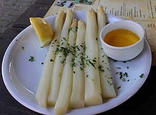
Asparagus with butter as an accompaniment to sausages


At 12-16 cm, the "Franconian sausages" are significantly larger and also thicker than the Nuremberg sausages, which are only allowed to be produced in the city of Nuremberg. The coarsely twisted pork sausage meat tastes more like Mayoran, although every butcher has his own recipe. Usually you get three pieces on the plate.
nightlife
Hiking maps:
- Fritsch hiking maps 1: 50,000, No. 53 - Franconian Switzerland Nature Park, sheet south