Upper Palatinate hill country is the name for a tourist region in the northern Upper Palatinatewhich essentially comes from the western part of the district Neustadt an der Waldnaab consists. The region borders on the to the east Upper Palatinate Forest, in the north of that Fichtel Mountains, in the west to the Franconian Switzerland and in the south to the Hersbrucker Alb and the Upper Palatinate Jura.
places

The Upper Palatinate hill country is a tourist region with the holiday resorts
- 1 Eschenbach in the Upper Palatinate


 in the Wikidata database") - with the small and the large soot pond
- with the small and the large soot pond - 2 Neustadt am Kulm - with the extinct volcanic cone Rauher Kulm
- 3 Park stone - is known for its widely visible basalt cone


Eschenbach in the Upper Palatinate

Neustadt am Kulm
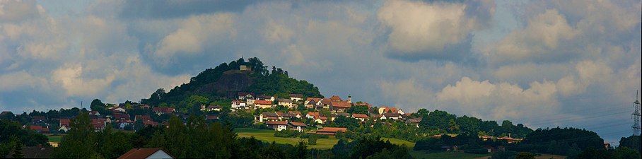
Park stone


- 4 Super tough - with the famous monastery
- 5 Grafenwohr - with the large military training area and partly American population and facilities
- 6 Kirchenthumbach -
- 7 Mud village - with the brewery


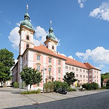
Super tough

Maria-Hilf-Church in Grafenwoehr

St. Laurentius in Kirchenthumbach

Trinity Chapel in Schlammersdorf


- 8 Vorbach -
- 9 coat -
- 10 Pressath -
- 11 Schwarzenbach -
- 12 Trabitz -
- 13 Weiherhammer -
- 14 Etzenricht -
- 15 Kohlberg in the Upper Palatinate -


Other goals
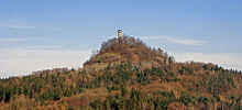
- The 1 Rough Kulm (682 m above sea level) near Neustadt am Kulm can be seen from afar. It is an old volcano that never erupted because the magma solidified before it reached the surface of the earth. Today there is a 25 meter high observation tower on the volcanic cone, which offers a panoramic view of theFichtel Mountains, the Franconian Alb and the rest of the northern Upper Palatinate offers.
- The 2 Park stone is a 595 m high basalt cone that towers over the city. At the top there is a church and the remains of the former castle, which fell into disrepair since 1756. In good weather you have a wide view over the surrounding area to the Fichtel Mountains, Stone forest and Upper Palatinate Forest. The mountain was included in the list of the 100 most beautiful geotopes in Bavaria. The basalt cone is the extraction slot of a former volcano that was exposed by weathering.

- One of the largest closed forest areas in Northern Bavaria is the Hessenreuther Forest with the Hesserberg (711 m above sea level). The near-natural mixed forests are hardly cut up by traffic routes and settlements and offer a variety of plant and animal species.
background
language
A northern Upper Palatinate dialect is spoken by the locals. The exception is Neustadt am Kulm, it is in the Upper Palatinate, but belongs to the Upper Franconian language area.
Due to the large military training area near Grafenwöhr, there are many Americans in the area, so that English is often spoken and English-language menus are also available.
getting there
By plane
The closest international airport is the ![]() Nuremberg Airport (IATA: NUE)
Nuremberg Airport (IATA: NUE) ![]()
![]()
![]()

In the street
The hill country lies between the motorways ![]() ,
, ![]() Bayreuth South to
Bayreuth South to ![]() Pegnitz and Autobahn
Pegnitz and Autobahn ![]()
![]() Falkenberg up
Falkenberg up ![]() Willows in the Upper Palatinate.
Willows in the Upper Palatinate.
By train
The area is largely rail-free, the nearest train stations are 1 Kemnath-Neustadt train station, 2 Neuhaus station, 3 Pressath station and 4 Weiden train station in the Upper Palatinate
mobility
The Haidenaab cycle path leads via Pressath partly through the area,
Tourist Attractions
activities
kitchen
- 1 Püttner brewery - Brewery inn with beer garden, hotel, gift shop for everything to do with beer and its own schnapps distillery.
climate
literature
It can be about that Internet an image brochure of the tourism region can be ordered.