

Transcarpathia (Закарпатська область, Sakarpatska oblast; short Закарпаття, Sakarpattja) is a region in the far west of the Ukraine with a limit to Poland, the Slovakia, Romania and Hungary. The region is from the Ukrainian part of the Carpathians embossed. Neighboring oblasts are Lviv and Ivano-Frankivsk
Regions
Transcarpathia essentially corresponds to the historical landscape Carpathian Ukraine.
places

- Uzhhorod - the capital of the region
- Mukacheve / Mukatschewo - Hungarian: Munkács
- Rakhiv / Rachow
- Winohradiv / Vinogradovo
- Berehove / Beregowo
Other goals

- Carpathian Biosphere Reserve incl. Carpathian National Park
- Synewyr National Park
background
Names and population
This region has always been populated by multiethnic people and, due to its location, has repeatedly changed its nationality, even in the 20th century. There are also various names in circulation. From the point of view of the main part of Ukraine, it lies beyond the Outer Eastern Carpathians ("Forest Carpathians"), which on Mount Hoverla - the highest point in Ukraine - reach a height of 2060 meters. Hence the name Sakarpattja or 'Transcarpathia'. From the point of view of the Central European neighbors, however, the region lies below the Carpathian Mountains, which is why they are in Czech and Slovak Podkarpatsko, in Polish Podkarpacie and in Hungarian Kárpátalja, also called 'Subcarpathian'. There is also the designation Carpathian Ukraine or Carpathian Ukraine, historically Carpathian Russia was also mentioned. According to historical and cultural-spatial criteria, the area is counted to Central and not to Eastern Europe. According to calculations by the Cartographic Institute of Austria-Hungary from 1887, the Carpathian-Ukrainian village of Dilowe is even the geographical center of Europe, which is marked by a monument.
Transcarpathia belongs to the traditional settlement area of the Russians (also known as the 'Ruthenians'), an East Slavic people who are linguistically and culturally closely related to the Ukrainians, but who differ from them. In Ukraine, however, the Russians are not viewed as an independent ethnic group, but rather as part of the Ukrainian nationality. Many Russians also simply refer to themselves as Ukrainians and not as members of their own people (only 0.8% stated their nationality as Russian in the last census), although they maintain their own cultural traditions and speak their own language (or dialect). In addition to Russians and Ukrainians, who make up the majority of the population (80%), there is historically a large Hungarian minority (12%), as well as Romanians, Russians, Roma, Slovaks and Germans.

The largest religious group in the oblast is Ruthenian Greek Catholic Churchwhich celebrates divine services according to the Byzantine rite (like the Orthodox), but recognizes the Pope as head (like the Catholics) and thus belongs to the group of "uniate Rome" or "Eastern Catholic Churches". The Ukrainian Orthodox of the Moscow Patriarchate are also strongly represented (unlike in the neighboring western Ukrainian oblasts, where most Orthodox belong to the rival Kiev Patriarchate or the Ukrainian Autocephalous Orthodox Church). Significant minorities belong to the Reformed Church in Transcarpathia, which is mainly frequented by ethnic Hungarians, and to the Roman Catholic Church. Jews now make up less than 1% of the population.
history
In the 9th century AD, the later Carpathian Ukraine was part of the Great Moravian Empire. From the 10th century until 1920 it belonged to Hungary and was part of the Habsburg monarchy from the 16th century until its fall. After the end of the First World War, the area was assigned to Czechoslovakia in the Treaty of Trianon in 1920, in which the Carpathian Ukraine was one of five countries. In the Czechoslovak census of 1930, the population consisted of 62% "Ruthenians" (ie Ukrainians and Russians), 16% Hungarians, 13% Jews and just under 5% Slovaks and Czechs. In the First Vienna Arbitration Award of 1938, the area was again separated from Czechoslovakia - which was in any case being dissolved as a result of the Munich Agreement - and reassigned to Hungary. After Hungary was occupied by the National Socialist German Reich in the spring of 1944, 100,000 Carpathian Ukrainian Jews were deported to Auschwitz and most of them were murdered.
In autumn 1944 the Red Army advanced into Carpathian Ukraine, which was initially reassigned to Czechoslovakia, but was ceded to the Soviet Union shortly after the end of the war. It became part of the Ukrainian Soviet Republic and remained with the now independent Ukraine even after the dissolution of the Soviet Union. In the autumn of 2008, Carpathian-Russian activists proclaimed an autonomous “Republic of Carpathian-Ruthenia”, but this had no practical impact and was largely ignored.
Politically, the Zakarpattia Oblast differs significantly from the other oblasts in western Ukraine, as the election results show. The turnout is usually much lower here. The candidates preferred by western Ukraine (Yushchenko, Tymoshenko) performed noticeably weaker here, while Yanukovych, who usually supports eastern Ukraine, was noticeably stronger than in other western oblasts.
Some clocks in Zakarpattia also work differently than in the rest of Ukraine - in the literal sense of the word. In some places the Central European time is still used instead of or in addition to the Eastern European or "Kiev" time.
language

The only official language is Ukrainian, only in some municipalities does Hungarian have official status. A large part of the population (estimated to be over 500,000) speaks the Carpathian-Russian language, which is closely related to Ukrainian and is only viewed as a dialect by both the official side and some speakers themselves. Almost 13% speak Hungarian and just under 3% each speak Romanian and Russian, the latter also being widely used as a second language. German speakers are only a very small minority.
getting there
By plane
Uzhhorod has an airport Uzhhorod International Airport![]()
![]()
![]() (IATA: UDJ) , which calls itself international, but is actually only served by scheduled flights from Kiev-Schuljany. The next major airport on the Ukrainian side is in Lviv (230 km / a good 3 hours by car from Mukatschewe), there are also direct flights from German-speaking countries. Due to the border location, the airports are even closer Košice in Slovakia (105 km; approx. 1:45 by car from Uzhhorod) and Debrecen in Hungary (150 km / a good 2 hours by car).
(IATA: UDJ) , which calls itself international, but is actually only served by scheduled flights from Kiev-Schuljany. The next major airport on the Ukrainian side is in Lviv (230 km / a good 3 hours by car from Mukatschewe), there are also direct flights from German-speaking countries. Due to the border location, the airports are even closer Košice in Slovakia (105 km; approx. 1:45 by car from Uzhhorod) and Debrecen in Hungary (150 km / a good 2 hours by car).

By train
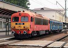
The Euronight Prague – Kiev runs through Transcarpathia with stops in Chop, Batjowo, Mukacheve, Karpaty and Swaljawa (in Chop there is a connection to Uzhhorod). For example, you can get from Berlin to Mukatschewe in less than 24 hours with just one change, and from Dresden in under 22 hours.
You can travel through Hungary with the Intercity Budapest–Zahony drive, where there is a connection to a regional train to the Ukrainian border station Chop several times a day. From there you can go further in the direction of Uzhhorod and Mukacheve. For example, the fastest connection from Munich to Uzhhorod with three changes takes just under 14 hours, and from Vienna 9½ hours.
From Lviv there are D-trains several times a day in the direction of Zakarpattia (Swalyava, Karpaty, Mukacheve, in some cases further to Batjowo, Chop and Uzhhorod). It takes about 4 hours from Lviv to Mukacheve. So you can drive from Berlin via Warsaw and Lviv and get to Mukacheve in about 21:40 hours.
In the street
You drive by car from northern or central Germany through Poland and Slovakia, from southern Germany through Austria and Hungary. From Vienna to Uzhhorod it is about 600 kilometers, for which you need between 5½ and 6 hours of pure driving time.
From Slovakia the national road 19 / European road 50 leads from Michalovce via the border crossing Vyšné Nemecké to Uzhhorod (which is located directly on the Slovak border).
Through Hungary you can take the M3 motorway to Nyíregyháza drive and then - depending on your destination in Transcarpathia - either take the national road 4 / European route 573 to the border crossing Záhony and on to Uzhhorod or you stay on the M3 to its end and then continue on the national road 41 to the border crossing Beregsurány and from there in the Mukacheve area or the eastern part of Zakarpattia.
The most important connection between the core Ukraine and Transcarpathia is the M 06 (European route 471) from Lviv to Mukacheve and Uzhhorod. The other Carpathian crossings are in poor condition and / or very winding, which is why their use would usually take longer. The east of the oblast (Rakhiv; Carpathian Biosphere Reserve) can be reached on the H 09 Ivano-Frankivsk–Mukacheve.
There are larger border crossings at Halmeu / Newetlenfolu and between Romania and Transcarpathia Sighetu Marmației/ Solotvyno. There is no border crossing from Poland.
mobility
Tourist Attractions

The south of the Zakarpattia Oblast belongs to the historical region Maramureș/ Máramaros, which, according to today's political borders, is largely in Romania. It is known for its historical wooden churches, in the Ukrainian part about 15 of these special places of worship have been preserved.
activities
As a leisure activity, sport is in the foreground.
kitchen
nightlife
security
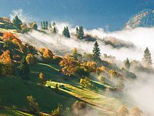
climate
Transcarpathia is relatively well protected south of the Carpathian Arc, which usually results in significantly longer periods of good weather in summer than in Germany. If, however, cold air from Russia makes its way in the winter when there is a high in Russia, the Carpathian Mountains only provide limited protection from freezing temperatures, and the winters can be cold and snowy, because the Carpathian Mountains are not a climatic divide, but merely a weather divide. During the very warm summer months, which are characterized by south-easterly winds from the Balkan region, which in turn can contain slight minus degrees with snowfall in winter. Because in the Balkans it can also get quite fresh and snowy in winter, but with a pronounced Adriatic low it can quickly go into double-digit plus areas for a few days, even in high winter.