The Ostallgäu is the eastern part of the Allgäu and lies in the administrative district of Swabia of the Free State Bavaria.

Regions
| location | ||
| ||

The Ostallgäu region is not exactly defined. The southern border is formed by the ridge of the Tannheimer Berge in Austria and the high plate in the Ammer Mountains, it extends in the west from the river Wertach to the east over the Lech out to Schwangau. To the north, the Ostallgäu extends to Central Swabia. In broad terms, this corresponds to the district of Ostallgäu with its administrative headquarters in Marktoberdorf.
The hilly landscape of the Alpine foothills formed by the last Ice Age falls from south to north towards the Danube. The northern part is predominantly characterized by agriculture, while grazing and forestry are increasing towards the south. The southern part of the region is particularly interesting for tourists, mentioning the attractive mountains of the northern Limestone Alps, and the castles and palaces of the region are at least as important. It is not for nothing that people speak of the southern part of the Ostallgäu King angle.
places

- 1 Kaufbeuren


 in the Wikidata database") - Independent city, with over 40,000 inhabitants the largest city in the region
- Independent city, with over 40,000 inhabitants the largest city in the region - 2 Marktoberdorf - Administrative seat of the Ostallgäu district
- 3 Feet - City on the Lech and the center of the Königswinkel
- 4 Buchloe - Rail transport hub


.jpg/350px-Buchloe_Luftaufnahme_(12).jpg)
Places in the southern Allgäu, in the Königswinkel and Auerbergland
- 5 Schwangau · With the royal castles Neuschwanstein and Hohenschwangau
- 6 Pfronten · With the Falkenstein ruins
- 7 Nesselwang
- 8 Eisenberg (Allgäu) · With the castle ruins Eisenberg and Hohenfreyberg
- 9 Hopferau
- 10 Vineyards on the Forggensee
- 11 Horseheads
- 12 Backwood
- 13 Seeg
- 14 Halbch
- 15 Lechbruck am See
- 16 Stötten am Auerberg


.jpg/320px-Halblech_Luftaufnahme_(2019).jpg)


Some of the places further north are also of tourist interest
- 17 Aitrang
- 18 Biessenhofen
- 19 Irsee · With the former Benedictine monastery
- 20 Obergünzburg]


Other goals
background
The landscape was shaped by the Würm Ice Age. Their glaciers formed valleys and depressions, which were then filled by the meltwater. A whole series of lakes were created in this way. Some of these lakes silted up over the centuries and formed ecologically significant moors. The largest lake is the Forggensee with an area of 15 km², but it is a man-made reservoir around 1950.
language
getting there
mobility

Tourist Attractions
Castles
- Royal castles Neuschwanstein and Hohenschwangau in the Hohenschwangau district of the village Schwangau
ruins
- Hohenfreyberg ruins and Eisenberg ruins at Eisenberg (Allgäu)
- Falkenstein
Churches and monasteries
- Irsee Monastery

Lakes
- Forggensee
- Alpsee
- Weissensee
- Hopfensee
- Elbsee
- Bachtelsee (water bird paradise)
- Schwaltenweiher between Backwood and Seeg located
- Schmuttersee
Mountains and viewpoints
- Auerberg
- Breitenberg (with mountain railway)
- Tegelberg (with mountain railway)
- Säuling
- Aggenstein
activities
- Riding and hiking with and on dromedaries from the Allgäu camel farm in Halbch.
kitchen
- White lacquer. is a semi-hard cheese (fat content 45% dry matter) made from cow's milk with a strongly piquant, salty taste. The salinity is around 5%. It is also known as beer cheese, but the name comes from the white, lacquer-like smear on the cheese surface and has been protected across Europe since 2015. It is only produced by Allgäuer Hof-Milch GmbH in Sonthofen. It can be eaten diced or dressed with beer, or as an ideal addition to cheese spaetzle.

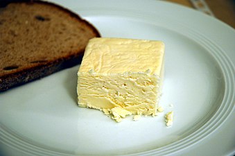
Weisslacker with bread

nightlife
security
Practical advice
Ostallgäu tourism association, Schwabenstrasse 11, 87616 Marktoberdorf. Tel.: 49 (0) 8342 911 313.
- KönigsCard: Holiday guests who book their stay with Königscard hosts receive numerous discounts with the free Königscard. The Königscard is available in the regions Ostallgäu, Ammergau Alps, Lechtal-Reutte Nature Park and Blue land.