| Portopalo of Capo Passero | ||
 | ||
| State | Italy | |
|---|---|---|
| Region | Sicily | |
| Territory | Syracusan | |
| Altitude | 20 m a.s.l. | |
| Surface | 15.09 km² | |
| Inhabitants | 3.900 (2016) | |
| Name inhabitants | Portuguese | |
| Prefix tel | 39 0931 | |
| POSTAL CODE | 96010 | |
| Time zone | UTC 1 | |
| Patron | San Gaetano of Thiene | |
Position
| ||
| [link not working]Tourism site | ||
| Institutional website | ||

Portopalo of Capo Passero is a city of Syracusan, territory of the Sicily.
To know
The municipal territory represents the southernmost point of the Sicilian island. In its territory there is the island of Capo Passero which takes its name from the territorial extremity of Capo Passero located a few meters away.
Geographical notes
The city rises at an altitude of 20 meters above sea level. in the extreme portion of the territory of south-eastern Sicily. In the Italian territory is further south there is only the scattered municipality of Lampedusa and Linosa located inisland of Lampedusa at the archipelago of Pelagie islands. A few kilometers away is the small and characteristic island of the Currents.
When to go
Tourists and vacationers populate the town at all times of the year.
Background
The territory was originally called Capo Pachino, later Terra Nobile and finally Porto Palo. Founded by Don Gaetano Deodato Moncada until 1812, following the feudal abolition, it was under the administrative control of Known. Subsequently it passed under the decurionate of Pachino, finally in 1974 it became an autonomous municipality of Sicily.
How to orient yourself
How to get
By car

From Sicily the territory can be reached via the European road E45 and the A18 motorway that connects Syracuse to Rosolini and is connected to the provincial roads 26 and 8 that connect its territory to Pachino and other neighboring municipalities.
On the train
The Syracuse railway line-Gela-Canicattì serves the nearby stations of Known and Rosolini.
How to get around
What see

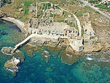
- Tafuri Castle. Historic residence located in a dominant position.
- Capo Passero Island. Southernmost point of southeastern Sicily
- Island of the Currents. Small island with a rounded shape located a few kilometers from the mainland. It is characterized by the presence of a large rectangular coastal lighthouse.
- Tonnara Vendicari. Industrial archeology monument.
- Cozzo Spadaro lighthouse. Coastal lighthouse located in Portopalo.
Events and parties
- Feast of San Gaetano.
 August 7. Patronal feast of Portopalo di Capo Passero.
What to do
Shopping
How to have fun
Where to eat
Where stay
Safety
How to keep in touch
Around
Itineraries
- European path E1, unites North Cape in Norway to the island of Capo Passero.
Other projects
 Wikipedia contains an entry concerning Portopalo of Capo Passero
 Commons contains images or other files on Portopalo of Capo Passero