| Vendicari Wildlife Reserve oriented nature reserve | |
 | |
| Area type | Oriented nature reserve |
|---|---|
| State | Italy |
| Region | Sicily |
| Territory | Syracusan |
| Surface | 1,512 ha |
| Foundation year | 1984 |
| Institutional website | |
Vendicari Wildlife Reserve oriented nature reserve is a protected area located in the province of Syracuse precisely between Known is Marzamemi.
To know
The Vendicari Wildlife Oasis oriented nature reserve is a particularly important protected natural area due to the presence of marshes that serve as a stopping place in the migration of birds.
Geographical notes
The reserve is located on the Ionian coast of eastern Sicily precisely between the territory Known is Pachino, but actually bordering the archaeological site of Eloro to the north and the hamlet of Marzamemi South. The coast is varied and alternates between sandy beaches and a rocky coast. The importance of the site is determined above all by the presence of marshes such as:
- 1 Small swamp the northernmost of the marshes.
- 2 Great swamp the one closest to the trap, used in the past as a salt pan for which regular divisions into tanks are visible.
- 3 Pantano Roveto it is located in the middle of the reserve and welcomes many birds thanks to its size.
- 4 Pantano Sichilli the southernmost. Compared to the others, it is more evidently subject to seasonal level variations. At the junction point between the beach and the Trigona path there is an often flooded passage, while in summer it is passable and allows you to see the marsh more closely.
Not far from the coast, theVendicari islet.
When to go
Vendicari can be visited in every season of the year, each of them allows different activities depending on the environmental conditions. If in summer the high temperatures allow you to come mainly for the sea, in winter and in the mid-seasons you can devote yourself to excursions, walks and even birdwatching. Temperatures are acceptable in winter, especially on sunny days, while in summer the heat and strong sun can also be excessive.
Background
Provided by a law of the Sicily Region of May 1981, it was officially established in 1984, after the then Minister of Agriculture and Forestry Filippo Maria Pandolfi declared 1450 hectares of land "wetland of international importance", according to the Convention of Ramsar from 1971. It was actually made available only in 1989. It is managed by the Regional State Forestry Company.
How to get
By plane
The airports of eastern Sicily are:
 Catania airport (Catania Fontanarossa Airport "Vincenzo Bellini". IATA: CTA), Via Fontanarossa, 20, Fontanarossa (By direct bus of the Interbus company, one every hour approximately.), ☎ 39 0957239111.
  00:00-24:00. Airport for national and international flights.

- Comiso Airport (Pio La Torre Airport) (Direct bus connections only from Catania), ☎ 39 0932 961467, @[email protected]. Airport opened in 2007. Mainly operates seasonal and charter flights.
By car
For Calamosche and main entrance:
- From the highway
 exiting at the interchange Known. Then take
  direction Known and take the roundabout heading south into the
  , after a few kilometers the entrance will be on the left.
For Eloro:
- From the highway exiting at the interchange Known. Then take direction Eloro / Noto Marina continue until the indication Eloro Beach.
For South Vendicari:
- From the highway exiting at the interchange Known. Then take direction Known and take the roundabout heading south into the , after a few kilometers (past the Vendicari entrance) turn in the direction Saint Lawrence. At the crossroads, turn left to turn right at the IX road fork.
On the train
The closest station is that of Noto.
By bus
There are no buses to get to Vendicari, except for organized excursions.
Permits / Rates

From August 2020 admission to the reserve is € 3.50.Within the reserve there are provisions. For example, it is forbidden to access dogs, to introduce or uproot plants, to bivouac, to light fires and to climb over the guards.
There are several accesses to the reserve:
- 5 Main entrance main manned access to the reserve.
- 6 South entrance of Vendicari manned access to the south area.
- 7 Calamosche entrance entrance to the Calamosche beach.
- 8 North entrance, Eloro north entrance of the Reserve near Eloro.
How to get around
All entrances are equipped with sufficient spaces to park the car with paid service:
- 9 Eloro parking although there is little space, it is also possible to park along the road.
- 10 Calamosche parking
- 11 Vendicari entrance parking
- 12 IX street parking (South Vendicari) along the road it is impossible to park, at the end there is paid parking.
Inside the reserve you move on foot following the signs. Access to bicycles is not forbidden but it is particularly difficult due to the sometimes extremely sandy or rocky terrain, therefore it is not recommended.
As in all reserves inside there are several inaccessible areas for the protection of flora and fauna. Some stretches of the beach are closed to facilitate the arrival of the turtles and the hatching of the eggs. While the marshes are the resting place for birds, observation huts have been set up along the marked paths to admire them.
Theoretically it is possible to travel the reserve from north to south and vice versa, however apart from the distances there is, especially in the winter period, an impediment linked to the forced passage next to one of the marshes which, unless you have boots, this is impossible for the presence of water.

What see

- 1 Latomie (Stone quarries) (Between the beach of Marianelli and that of Calamosche). Stone quarries of the 5th century BC linked to the city of Eloro. The cut points and some square blocks are visible.

- 2 Hellenistic tanks (A short distance from the Museum). Right by the sea, not far from the museum, there are small tanks from the Hellenistic period identified as tanks for the processing of fish and garum. The fact that this tradition has remained linked to this area for centuries is significant, as the former tonnara of Vendicari is just a few meters away. This means that the abundance of fish in the Ionian sea has always been a source of subsistence and trade.

- 3 Ecomuseum visitor center (Near the tonnara).
 free. Morning. The museum is located in what were once the fishermen's houses. Thanks to the support of the Ente Fauna association and the support of the University of Catania, a small museum of local flora and fauna has been opened. Thanks to the support of photographs and captions, it is possible to follow a naturalistic-cognitive path.


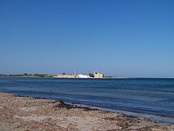
 4 Sveva Tower (next to the trap). The tower was built in the 15th century to be a point of observation and control of the pirate phenomenon. At that time the Turkish pirates infested the Sicilian coasts and their arrival terrified the population since in addition to the raids, they generally killed the population without mercy. For this reason a defensive system of coastal towers was erected that surrounds the whole of Sicily and that allowed the signaling of danger even at great distances. An episode of the Montalbano series was filmed in front of the tower.
- 5 Tuna fish (Next to the Swabian Tower). The tonnara represents one of the finest examples of industrial archeology. Until the 50s of the last century it was in use by exploiting the great fishiness of the surrounding sea. Today, in addition to being a particularly beautiful place to take photos, remains the structure of the shed where the tuna was packed as well as the ovens and the chimney. Next to it is also visible the canal that connects to the salt pans, in the past also used for slaughter.

- 6 Saline. Located between the main entrance and the large quagmire, the salt flats represent the remnant of an ancient salt extraction activity. The salt flats no longer in use are used by migratory birds as a place of rest like the nearby marshes.
.jpg/150px-Facciata_della_Trigona_(da_lato).jpg)
- 7 The trigona (Byzantine Cuba). The trigona is a building that takes its name from the three internal niches, moreover the term cuba is applied to those buildings, typically Sicilian with a cubic shape and with a hemispherical upper cap. These buildings are from the Byzantine era, it is intended around the VII-VIII century AD. The building was originally isolated, today closed by side constructions that do not highlight its architectural beauty. The trigona faces west and today inside, except for the still intact structure, there is no trace of the probable decorations.
- 8 Byzantine catacombs. The small catacombs of Vendicari consist of underground rooms with some clearly visible tombs. Here the dead were buried in the Byzantine era. There are no traces of frescoes and the tombs are simple, some single others familiar. To enter it, simply use a small flashlight and pay attention to how you move inside.
 One of the catacombs of Vendicari

What to do
Beach life
- 1 Eloro beach. Splendid beach on the north side of the reserve next to the ruins of the Greek archaeological site of Eloro.
- 2 Marianelli beach. Beach located immediately after that of Eloro. It is generally less crowded than the first and is famous for being a nudist beach.
- 3 Cala Mosche beach. Beach inside a cove. One of the most famous of the reserve but reachable after a half hour walk from the parking lot. Bring protection along the way.
- 4 Vendicari beach. The main and most accessible beach of the reserve, with the Vendicari Tower in the background. As beautiful as the beach is, it is almost always full of oceanic posidonia, a biological indicator of cleanliness of the sea, but which may not make swimming pleasant.
- 5 Cittadella beach. The last beach of the reserve, not too far from the car park and the entrance.
Birdwatching


Vendicari undoubtedly represents a safe haven for over 250 bird species. Especially during the migration period (spring and autumn) but also during the wintering period (winter) this wetland is an excellent place to observe migratory birds in particular: the pink flamingos, i waders, the gray herons, the storks, the Mallard, i seagulls, i cormorants and the knight of Italy. Migratory birds find the reserve as the southernmost point in Europe before making the crossing of the Strait of Sicily to reach Africa.
Inside the reserve there are several observation huts, equip yourself with binoculars or telescopic lenses to be able to observe or photograph them:
- 6 Pantano Piccolo workstation.
- 7 Pantano Grande station.
- 8 Pantano Roveto station.
- 9 Pantano Scichilli north station.
- 10 Pantano Scichilli south station.
Excursions
Some associations and tourist agencies organize excursions to Vendicari including:
- Hermes Sicily, ☎ 39 346 5787561, @[email protected]. Syracuse tourist agency, also offers tour packages for other destinations in the province of Syracuse and Ragusa.
Shopping
It is not possible to make purchases within the reserve. At the entrances there are often ice cream and soft drinks vendors.
Where to eat
All the places indicated are mainly open in summer.
At the south entrance there are wooden bars which only open in summer.
- 1 From the Terra Bistrot, Via Bruno Ragonesi (near the main entrance of the Vendicari Reserve), ☎ 39 0931 184 0778, 39 333 455 8132, @[email protected].
Where stay
- Agrimaccaccari (agricamping), @[email protected].
- 1 Camping da Vinci, SP 19 (at the crossroads CODALUPO SP 11 km 8.5 turn right, after 10 meters turn left or always on the SP 19 at km 9.9 on the right there are signs), ☎ 39 339 749 9991.
- 2 [link previously not working]Calamosche farmhouse, Loc. Calamosche, ☎ 39 347 858 7319.
Safety
The reserve is essentially a safe place. In the summer, the biggest problem is the sun, since there are few shadows and walking in the hottest hours can be problematic.
In the late afternoon and after sunset the presence of mosquitoes is very annoying due to the presence of marshes, it is therefore advisable to dress appropriately.
In winter, especially after heavy rains, some paths could be flooded or muddy.
It is not possible to access with the ball or beach rackets.
In some parts of the reserve the border between the paths and the protected areas is not always clearly identifiable. To avoid entering protected areas, it is always advisable to avoid secondary paths.
How to keep in touch
Telephony
Except in some areas, cellular communications are covered by the network.
Around
- Known is Avola
- Marzamemi
- Cavagrande del Cassibile nature reserve
- 13 Noto radio telescope, Contrada Monte Renna. Radio telescope for radio observation of the sky.
- 14 Villa del Tellaro (Roman Villa of Tellaro) (south of Noto, from the SP 19 towards Noto), ☎ 39 0931 573883. free. Mon-Sun 08.30-19.45. Remains of a Roman villa from the 4th century BC with some beautiful mosaics.
Other projects
 Wikipedia contains an entry concerning Vendicari Wildlife Reserve oriented nature reserve
 Commons contains images or other files on Vendicari Wildlife Reserve oriented nature reserve