

The Renchtalsteig is a long-distance hiking trail around the Renchtal in the Northern Black Forest. The 5 stages lead from Bottenau Oberkirch 98 km past popular hiking destinations Lautenbach, Oppenau and Bad Peterstal-Griesbach and finally end back in Oberkirch.
background
The path was designed jointly by the local departments of the Black Forest Association and the municipalities and tourist information centers in Renchtal. He should meet the criteria from the start Quality hiking trail of German Hiking Association and was opened as such in 2011. This means that the route has an attractive route and that it is easily accessible and signposted.
In 2016, the trail was no longer recertified as a quality hiking trail, as the course of the trail was slightly changed this year and the required proportion of 35% natural trails in the entire trail could no longer be achieved.[1]
preparation
The Renchtalsteig mainly leads on gravel forest paths. However, there are some stairs and steep sections, especially on the third stage around the Teufelskanzel, that require surefootedness and sturdy shoes.
Originally, the stages were planned in such a way that at each end of the stage there is (at least) one place to stop for refreshments and overnight stays. However, this no longer works in Allerheiligen (4th / 5th stage) and Alexanderschanze (3rd / 4th stage). If you want to hike the path continuously, you have to take this into account and plan alternative quarters. Alternatively, you can also walk on sections individually, also independently of each other, all stage destinations are served by bus lines in regular service at least during the day. However, it is advisable to study the timetables beforehand in order to avoid unpleasant surprises.
getting there
The places in the Renchtal are all connected to the Renchtalbahn, which runs from 6:00 a.m. to 10:00 p.m. between Offenburg and Bad Griesbach runs. Offenburg, on the other hand, can be reached via various regional, ICE and IC routes.
The first stage of the Renchtalsteig begins in the Oberkirch district of Bottenau, which is a little off the Renchtalbahn. You can get there via the regional bus lines RB1 or RB2, which run from 1 Oberkirch station drive off and on Bottenau town hall stop where the Renchtalsteig begins. A trip on the RB2 line takes only 5 minutes and is therefore recommended. The RB1 line goes in the opposite direction and therefore takes more than 25 minutes from the train station to Bottenau.
Alternatively, you can walk the piece from the train station to Bottenau. It is about 3 extra kilometers through the lovely Bottenau valley if you follow the Ortenau Wine Trail (and don't pluck every fruit tree).
The last stage of the Renchtalsteig officially ends at the Schauenburg. From there it is another 1.8 km to Oberkircher train station.
Stages
1st stage: Bottenau - Oppenau (22.7 km)
| Place / sight | route (km) | height (m aboveNHN) | additional Information |
|---|---|---|---|
| 1 Bottenau town hall | 0 | 192 | Bus connection |
| 1 St. Wendelin | 0,8 | 255 | Pilgrimage chapel |
| 2 Staufenberg Castle | 3,5 | 365 | Vineyard with wine bar |
| 3 Brandstetter Chapel | 1,4 | 319 | Pilgrimage chapel |
| 4 Furnace hole | 6,1 | 592 | Refuge |
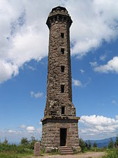
| 5 Moss head | 2,9 | 872 | Observation tower |
| 1 Calicuttons | 4,2 | 503 | Hotel Restaurant |
| 2 Huguenots | 3,8 | 291 | 0.4 km to the train station Oppenau |


Directions
This is the starting point of the Renchtalsteig Bottenau town hall on the K 5369. From there it goes uphill through vineyards first to St. Wendelin, a pilgrimage chapel that dates back to the Middle Ages, the current building dates back to the mid-18th century. It continues on promising ways to Staufenberg Castle. Staufenberg Castle is located on a mountain spur with a wide view of the Durbach vineyards as well as the Rhine Valley, with good visibility of the Vosges. The castle still belongs to the family that shares its name with the region, the Margraves of Baden, who run a winery here. The path leads almost parallel to the slope through vineyards to Brandstetter Chapel at the top of the K 5369 pass between Bottenau and Durbach. This is where the ascent to the Moss headwho, along with the Kandel-Höhenweg is achieved. The "Moos" is the heavily forested ridge that separates the Renchtal from the Kinzig valley in the south. At the highest elevation, the Mooskopf, there is a stone observation tower, which since the devastating hurricane "Lothar" Christmas 1999 has again offered a clear all-round view. From the Moosturm the path leads steadily downwards Calicuttons to the Huguenots near Oppenau.
At the stage destination Oppenau there are numerous places to stop for refreshments and overnight stays. On the way you can stop at Staufenberg Castle and the Kalikutt, the Kalikutt also offers overnight accommodation. The latter is an alternative for those who want to save the descent (and subsequent ascent) to Oppenau.
2nd stage: Oppenau - Bad Peterstal (16.4 km)
| Place / sight | route (km) | height (m above sea level) | additional Information |
|---|---|---|---|
| Huguenots | 0 | 291 | 0.4 km from the train station Oppenau |
| 6 Ibacher lumber yard | 3,5 | 745 | Lookout point |
| 2 Lochbergwasen | 3,7 | 650 | Hikers' car park with snack bar and kiosk |
| 7 Hermersberger Hut | 5,4 | 825 | Lookout point |
| 3 Kurhaus Bad Peterstal | 3,8 | 400 | 0.4 km to the train station Bad Peterstal |
Directions
Of the Huguenots the path leads steeply uphill to Ibacher lumber yardwhere paragliders start when the wind is blowing. The path then leads almost parallel to the slope Lochbergwasen, Top of the pass between Rench and Harmersbachtal. It goes through many wooded passages along with the Cross path Gengenbach – Alpirsbach continue to Hermersberger Hut. This is where the descent to begins Bad Peterstal.
Refreshments are only available on the way Lochbergwasen snack bar with a few benches in the fresh air and then at the stage destination Bad Peterstal; There are also places to stay overnight.
3rd stage: Bad Peterstal - Alexanderschanze (19.3 km)

| Place / sight | route (km) | height (m above sea level) | additional Information |
|---|---|---|---|
| Kurhaus Bad Peterstal | 0 | 400 | 0.4 km from Bad Peterstal train station |
| 8 Palm spring | 4,6 | 625 | Training home, no rest stops |
| 9 Lake level | 2,2 | 942 | Junction to Glaswaldsee, Connection to the Westweg |
| 10 Lettstädter Höhe | 1,6 | 964 | Refuge |
| 11 Sexauer hut | 2,9 | 769 | Barbecue area with shelter |
| 12 Devil's pulpit | 1,3 | 944 | rock |
| 13 Hildahütte | 2,1 | 915 | Refuge |
| 4 Alexanderschanze | 4,6 | 968 | Hikers' parking lot, bus connection |


Directions
The path leads from Kurhaus Bad Peterstal over the Holchen waterfall to the former forest hotel Palm spring. After climbing to the Lake level the Renchtalsteig meets the for the first time Westweg. With a view of the Glaswaldsee it goes on to Lettstädter Höhe. The path leads downwards past the Rappenschliff to Sexauer hut. Steep uphill through the Devil's pulpit the Westweg is reached again. After Hildahütte the promising high path leads to Alexanderschanze at the B 28.
There is no place to stop for a break on the way. At the Alexanderschanze stage destination, too, the door has been locked since 2014. The next possible overnight stay is at the Hotel Zuflucht (see below) or in the local area of Kniebis, about 3 km to the east, which means a corresponding detour or bus ride.
4th stage: Alexanderschanze - Allerheiligen waterfalls (23.2 km)

| Place / sight | route (km) | height (m above sea level) | additional Information |
|---|---|---|---|
| Alexanderschanze | 0 | 968 | Hikers' parking lot, bus connection |
| 3 Renchtalhütte | 5,8 | 752 | Serviced hut |
| 1 refuge | 4 | 954 | Hikers' car park, hotel |
| 14 Lothar path | 2,9 | 930 | Junction to the Lothar path |
| 15 Steinmäuerle | 3,5 | 1.000 | Hikers' parking lot and view |
| 2 Grinding head | 0,8 | 1.056 | High altitude hotel |
| 16 All Saints Day | 3,8 | 637 | Monastery ruins and monastery courtyard |
| 17 All Saints Waterfalls | 2,4 | 518 | Hikers' parking lot, bus connection |


Directions
Of the Alexanderschanze the path leads past the Rench spring to Renchtalhütte. This is followed by the ascent to refugewhere the Westweg is reached again. With a view of the Lierbachtal and to the Vosges it goes on to Grinding head, the highest point of the Renchtalsteig. This is where the descent to the All Saints monastery ruins. From there the path leads over lookout rocks above the water falls to the hiking car park.
There are refreshments at the Renchtalhütte, Zuflucht (here you can also stay overnight), Schliffkopf (here you can also stay overnight) and in All Saints' Day. There is no overnight accommodation at the stage destination of All Saints' Day, the most you can do is take bus 7125 (“Naturerlebnislinie”) in the direction Oppenau or Ottenhöfen to take.
5th stage: Allerheiligen waterfalls - Schauenburg castle ruins (16.4 km)
.JPG/220px-Ruine_Schauenburg_(2).JPG)
| Place / sight | route (km) | height (m above sea level) | additional Information |
|---|---|---|---|
| All Saints Waterfalls | 0 | 518 | Hikers' parking lot, bus connection |
| All Saints' Day | 1,3 | 637 | Monastery ruins and courtyard |
| 18 Sohlberg | 4,5 | 665 | Parking lot for hikers |
| 19 Simmersbacher Cross | 2,8 | 602 | |
| 20 Rappenschrofen | 0,4 | 641 | Lookout point |
| 21 Schwalbenstein | 4,9 | 410 | Hussar memorial, lookout point |
| 22 Schauenburg | 1,9 | 375 | Castle ruins |
| 5 Schauenburg car park | 0,6 | 320 | 1.8 km to the train station Oberkirch |

Directions
The path leads from the hiking car park to the Waterfalls along back to All Saints monastery ruins. About St. Ursula and Sohlberg it goes to Simmersbacher Cross. Following the rock path for a while, the path leads to Rappenschrofen and on to Schwalbenstein with a view of the Rhine plain. The Renchtalsteig ends below the Schauenburg ruins at the parking spot. From there, along the path with the blue diamond, it is another 1.8 km to the Oberkirch station.
There are refreshment stops and places to stay overnight in Oberkirch.
trips
Individual evidence
- ↑Simon Allgeier: Renchtalsteig loses the quality hiking trail certificate, bathe online, November 08, 2016, accessed on September 01, 2020.
literature
- Black Forest Middle / North Nature Park (Ed.): Hiking on the Renchtalsteig.
- Martin Kuhnle: Black Forest middle / north. Bergverlag Rother, Munich 2013, ISBN 978-3-7633-4420-8 , Pp. 122-139.
Web links
- Renchtalsteig - Website of Renchtal Tourismus GmbH
- Renchtalsteig - Website of the Schwarzwald Tourismus GmbH
- Waymarked trails - Overview map, elevation profile and GPX download of the Renchtalsteig based on OpenStreetMap data
- Black Forest hiking service - Hiking portal of the Black Forest Association with different map views and overlays (route network, signposts, accommodations, ...)