The Northern Black Forest is a largely forested low mountain range in southern Germany on the eastern side of the Upper Rhine Rift. There are deep valleys and many wooded mountains with raised bogs. The border to the central Black Forest is drawn roughly at the height of Freudenstadt.

Regions

Altitudes of the northern Black Forest. The main mountains are
- the 1 Hornisgrinde


 in the Wikidata database") , 1163 m, highest mountain in the northern Black Forest, and
, 1163 m, highest mountain in the northern Black Forest, and - the 2 Grinding head, 1055 m, both on the Schwarzwaldhochstrasse

- the 3 High ox head, 1055 m, near Forbach,
- the 4 Hohloh, 988 m, near Kaltenbronn / Gernsbach, Rastatt district


Western regions
- the Alb valley With Bad Herrenalb and Marxzell
- the Murgtal With Gaggenau, Gernsbach, Forbach and Baiersbronn
- Baden-Baden and environment
- the Renchtal With Bad Peterstal-Griesbach, Lautenbach and Oberkirch
- Buhl and Bühlertal
Eastern regions
- the Nagoldtal With Calw and Nagold
- the Enztal With Bad Wildbad
The transition from the Northern Black Forest to the Central Black Forest is roughly marked by a line that goes through the valley of the Rench Freudenstadt to Horb goes.
Neighboring regions are
- in the north the region Kraichgau-Stromberg,
- in the east that Neckar Valley and the Heckengäu,
- in the south of the Middle Black Forest,
- in the west the Baden Rhine Plain.
places

- 1 Baden-Baden. Chic health resort with an international reputation.
- 2 Bad Herrenalb. Health resort in the upper Alb valley.
- 3 Bad Teinach-Zavelstein. Health resort and half-timbered town with castle.
- 4 Baiersbronn. A place branched out across a few valleys with extensive hiking opportunities and top cuisine, the largest accumulation of Michelin stars in Germany.
- 5 Bad Wildbad. Spa, recreation, tourism and health location with a funicular on the Sommerberg; Bad Wildbad-Calmbach is also known as the "five valley town"; the south of Bad Wildbad includes the mountain towns of Aichelberg, Hünerberg, Meistern and Rehmühle. In the south-west are the high places Sprollenhaus, Nonnenmiss and Christophshof.
- 6 Buhl. At the foot of the Black Forest, known for plums.
- 7 Calw. County seat.
- 8 Ettlingen. At the transition to the Upper Rhine Plain.
- 9 Forbach. Deep in the Murg valley.
- 10 Freudenstadt. Regional center at an altitude of 700 to 800 m at the transition from the northern to the central Black Forest.
- 11 Gaggenau. In the Murg valley.
- 12 Nagold. Half-timbered town with a very beautiful cityscape.


_06_ies.jpg/350px-Bad_Wildbad_(Sommerberg-Hotel)_06_ies.jpg)


- 13 Oberkirch. Small town in the Renchtal between orchards and grapevines.
- 14 Pforzheim. Watches, jewelry and gold processing.

.jpg/350px-Panorama_Nagold,_Stadtkirche_und_Enz_(1).jpg)
.jpg/220px-Waldweihnacht_Aichelberg_(Foto_von_24.12.2017).jpg)
- 15 Sasbachwalden. Flower and wine village in the Black Forest.

Other goals
- 5 Black Forest National Park. The only national park in Baden-Württemberg. The tourist contact point is the National Park Center on the Ruhestein.

background
language
Depending on the place and region, Allemanisch, Swabian or Franconian. But always German.
getting there
The northern Black Forest has good transport links. Easily accessible airports are the Karlsruhe Baden-Baden Airport, the Stuttgart Airport, but also the airport Frankfurt. You can take the train to the ICE train stations in Baden-Baden or Karlsruhe, there are good branch lines mainly on the S-Bahn lines of the Karlsruhe Transport Association. The routes of the A5, A8 and A81 to the edge of the northern Black Forest, further federal highways are among others the B28 and especially the B500, the Black Forest High Road.
mobility
This applies to almost the entire Black Forest KONUS guest cardwhich enables holidaymakers to use local transport for free.
Tourist Attractions

The northern Black Forest is a popular holiday region with a few sights (e.g. castles, half-timbered towns) and a well-signposted network of hiking trails.
nature
Whether raised bogs, cirque lakes, meadows or dense forests - those who like peace and nature will feel at home in the northern Black Forest.
- 6 Mummelsee (directly on the Schwarzwaldhochstraße (B500).). The lake below the highest mountain in the Northern Black Forest is one of the most famous destinations in the Northern Black Forest and is accordingly very popular. The 250 m wide lake is framed by dark fir trees at 1036 m on the western slope of the Hornisgrinde. From the lake you can take a walk to the highest peak in the region with a lookout tower (great panoramic view). At the lake there is a parking lot and a hotel with excursion restaurants.

- 7 Hornisgrinde. An excursion to the highest mountain in the northern Black Forest with 1164 m can be perfectly combined with the Mummelsee. The summit with a restaurant opened in 2018 and a lookout tower can be easily reached on foot from the lake. To the south-east of the summit there is also a raised bog that can be viewed via a boardwalk.
- 8 All Saints Waterfalls. In a legendary gorge between Oppenau and Ottenhöfen, the Lierbach cascades down over 60 m in several cascades. The waterfalls are equipped with a well-developed path with many steps that can be climbed in both directions. At the top of the falls there is a ruined monastery from the 12th century.

- 9 Mercury. Baden-Baden's local mountain offers a beautiful overview of the city. The summit can be reached on foot or, more comfortably, via the Merkurbergbahn, one of the longest funiculars in Germany.

- 10 Hohloh (at Kaltenbronn). A high moor area with a small lake that invites you to go hiking in summer and cross-country skiing in winter. A little below at Kaltenbronn there is also a small lift system. At the summit is the Kaiser Wilhelm Tower with a view of the Swiss Alps (when visibility is very good). Large parking lot at the summit and gastronomy in Kaltenbronn.
- 11 Gertelbach Falls. The falls are in the upper area of the Bühlertal below the Black Forest High Road. The Gertelbach falls here at an altitude of 220 meters in numerous cascades (up to 7 m in height) to the valley. A mountain path opens up the romantic torrent in its steep valley, which is limited in places by cliffs. From the nearby Wiedenfelsen (located on the Bühlental - Schwarzwaldhochstraße near the hotel of the same name in the hairpin bend) you have a beautiful view of the Bühlertal.
.JPG/320px-Gertelbach-Wasserfälle_(1).JPG)
- 12 Karlsruhe ridge. The 400 m long rock ridge is located east of Ottenhöfen between 600 m and 750 m altitude. Over the steep ridge leads in unsecured Via ferrata (without ropes and ladders). If you want, you can also hike along a hiking trail to the side in the area of the mountain ridge.


- 13 Wildsee. Hidden in the thick forests of the national park is the Wildsee, which is one of the 9 remaining cirque lakes in the northern Black Forest. It is not far from the Ruhestein and the Darmstädter Hütte and can only be reached from there via a path full of obstacles down the slope of the Seekopf. But that also means that only a few hikers come here and the Wildsee lives up to its name.

- 14 Devil's mill. From the tower at the Teufelsmühle (906 m) you have a beautiful view of the Murg Valley. A toll road leads from Landstr. Bad Herrenalb - Loffenau on the devil's mill. Next to the tower is the Teufelsmühle restaurant and a hut belonging to the Black Forest Association that can be rented. The place is an old part of the Westweg and is located directly on the border between Baden and Württemberg. A rocky path (part of the Westweg directly on the ridge of the mountain) leads through the beautiful and untouched high moor, which is right in front of the house and is definitely worth a short hiking excursion when visiting the restaurant (good footwear recommended). The Teufelsmühle has had a public power supply since 2006, offers classic Black Forest cuisine, is comfortably furnished and has 8 beds for hikers and cross-country skiers.

Castles
There are also some beautiful castle ruins on the slopes and on the peaks of the northern Black Forest:
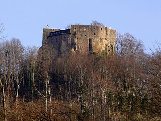
- 15 Hohenbaden Castle. The former seat of the Margraves of Baden is one of the largest castles in the region. From the old walls you have a good panoramic view of Baden-Baden below and a distant view of the Rhine plain and the Vosges. The castle courtyard of the ruin is also worth seeing. The castle and tower can be visited free of charge. There is a restaurant in the castle.

- 16 Old Eberstein. The ruin near Baden-Baden is open to visitors during the opening times of the restaurant and offers a panoramic view of the Murgtal and the dark forests of the northern Black Forest.
- 17 Yburg. The Höhenburg is located at the transition from the Upper Rhine Plain to the Black Forest on the summit of the 514.5 m high Yberg. It is the landmark of the Baden-Baden vineyards and the villages of Steinbach, Neuweier and Varnhalt. From the castle you have an excellent all-round view of the Rhine plain and the Black Forest.

- 18 Windeck Castle. From the facility near Bühl, which can be visited during the day in good weather, only the two keep, remains of buildings and parts of the curtain wall are preserved today. The hotel and restaurant "Burg Windeck" and the Vesperstube "Pferdestall" are now operated at the foot of the castle ruins.

- 19 Neu-Windeck Castle. Only a few remains of the wall remain from the castle near Lauf. The keep can be climbed as a lookout tower and offers a good panoramic view of the area.

- 20 Schauenburg. The castle, which is still in good condition between the vines of the Oberkirch winemakers, is a popular destination. There is a small museum in the cellar of the former chapel.

activities
hike
The northern Black Forest is a very popular hiking region with a well-marked and varied network of hiking trails. Several long-distance hiking trails also lead through the region, from Pforzheim three hiking trails head south: the Westweg leads to Basel, the middle ground after Waldshut-Tiengen and the east way to Schaffhausen. There is also a good network of nature and themed hiking trails. The Baiersbronn Wanderhimmel is a good example of this, or the escape route of Count Eberhardt von Bad Wildbad to Zavelstein.
To go biking
The region is popular with mountain bikers, and several cycle paths cross the northern Black Forest. The Nagoldtal cycle path is part of the Heidelberg-Black Forest-Lake Constance Cycle Route. Another highlight is the Enz Valley Cycle Path from Enzklösterle via Bad Wildbad to the mouth of the Enz in Bietigheim.
The northern Black Forest also offers mountain bikers with off-road experience in the bike park in Bad Wildbad, which can also be reached by public transport, the best conditions.
Winter sports
There are various ways to do winter sports in the northern Black Forest. There is an extensive network of trails (with trail fee) in the area of the Black Forest High Road. Alpinists, on the other hand, come e.g. B. at Mehliskopf near Herrenwies at their expense. For details on winter sports in the region, see the corresponding sections in the topic article "Winter sports in the Black Forest".
Climb
The region also offers good climbing opportunities. Here one Overview.
- 1 Batterfelsen. The reputation of the Battert near Baden-Baden as a climbing area goes back to Wilhelm Paulcke, who opened the first climbing routes on the Battert around 1885. Since then, a large number of easy to difficult routes (II to IX) have been committed. Some of the rock massifs and free-standing towers were named by the climbing pioneers after the mountains of the Dolomites and the Kaiser Mountains.

- 2 Falcon rock. There are several climbing routes of difficulty levels III to IX on this rock formation near Bühlertal. The best to reach is the rock from Plättig, where the former Schlosshotel Bühlerhöhe is located.

kitchen
Anyone who thinks of Black Forest ham or cherry cake when referring to the Northern Black Forest is certainly not wrong. However, the kitchen is much more versatile. There are excellent trout in the clear mountain streams. And in the community Baiersbronn there are three internationally renowned restaurants with a total of eight stars in the Michelin Guide.
nightlife
security
The crime rate in the Black Forest is negligibly low. The places can be safely accessed at all times of the day and night.
climate
In the heights of the Black Forest there is usually a light wind in summer, in the valleys it's cool. Therefore, even on very hot summer days, the perceived temperature is lower than the measured temperature.
trips
literature
Web links
official regional pages: