 | ||
| no picture on Wikidata: | ||
| Sandvig (Allinge-Sandvig) | ||
| region | Bornholm | |
|---|---|---|
| Residents | 1-759 (with Allinge) | |
| no value for residents on Wikidata: | ||
| Tourist info web | http://www.sandvig.ws | |
| no tourist info on Wikidata: | ||
| location | ||
| ||

Sandvig is a small place on the northern tip of Bornholm.
background

Sandvig is the northernmost town of Bornholm, right at the foot of the Hammerknuden (also called Hammeren), a large granite rock that forms the northern tip of Bornholm. Historically, Sandvig was primarily shaped by the stone quarries on Hammerknuden, as the place of residence of the workers, but it was also an attraction for travelers before the First World War, as demonstrated by numerous hotel buildings from this period. Sandvig is still a tourist center like the neighboring towns, but it has remained small and tranquil. Apart from numerous upscale hotels and a large campsite, there is hardly any tourist infrastructure in Sandvig. Many small shops that used to be around the port and in the small side streets from the port to the town have closed in the last 10 years, and there is no longer any tourist information on site. All of this is available in AllingeHowever, this makes Sandvig seem rather deserted outside of the high season.
The small town hardly offers anything spectacular, but small details worth seeing, pretty little houses in the Bornholm half-timbered houses and a small, beautiful beach. If you are looking for peace and nature around your holiday home, you are in the right place in Sandvig. A little more tourist bustle can be found in Allinge.
getting there
By plane
Bornholm's only airport is in Rønne, from the airport continue with the bus Rønne.
By bus
The following bus routes from BAT connect Sandvig to the rest of the island:
- Route 2: Klemensker - Hammershus - Allinge - Sandvig and back
- Route 7/8: Rønne - Hasle - Vang - Hammershus - Sandvig - Allinge - Gudhjem - Listed - Svaneke - Joboland - Aarsdale - Nexø - Balka - Snogebœk - Pederskirke - Aakirkeby - Arnager - Rønne Airport. This line is Bornholm's tourist bus route and operates at a reduced frequency outside of the summer season.
- * Route 10 Rønne - Nyker - Klemensker - Hasle - bus stop to Jons Kapell - Vang - Sandvig - Allinge and back on the same route.
In the street
You can reach Sandvig from Rønne Coming either via the small side street on the Hammershus Fortress, or across the main street from Allinge out.
By boat
Pleasure boats find a berth in the port of Sandvig, which is very small. The neighboring town has a larger guest harbor Allinge. Many sailors use the relatively sheltered bay in front of Sandvig to anchor there at night.
Sea kayakers can moor directly on the beach, the campsite is just 100 meters away.
By bicycle
Sandvig can be reached with a short detour from the national Bike route 10 (Bornholm Rundt), which leads from Rønne via Hasle, Helligpeder, Teglkås, Jons Kapell, Vang and Hammershus on the original route to Allinge, and then on around the entire island (approx. 110 km, mostly paved). Detailed route description with the route variant via Sandvig (with GPS track) in Bike tour wiki. For more cycle routes see Travel guide to Bornholm.
On foot
On the Kyststi, the coastal path around Bornholm, you come to Sandvig. This hiking trail is the old sea rescue route, on which the rescuers rushed to the aid of a ship in distress, in which they only approached the hair spot as far as possible by land. Only then did they launch the small boats to rush to help, which often enough remained very dangerous.
Coming from Hasle, the Kyststi leads around the Hammerknuden before Sandvig, where there was a small trading port in earlier centuries. Hikers who do not want to go around Hammerknuden, follow the signs to Opalsø / Hammersø from Hammerhavn and hike along the banks of the latter on the direct path to Sandvig.
mobility
The place is easy to explore on foot, but walkers and wheelchair users have to keep in mind some more steeply sloping streets.
Hammerodde, the northern tip of Bornholm, is also easy to get to on largely paved footpaths. Only the last 100 m before Hammerodde Fyr are gravel. All other paths around the Hammerknuden can only be used to a limited extent or not at all for people with reduced mobility.
Tourist Attractions
First of all, Sandvig is, of course, all about its "natural" sights around the granite rock Hammerknuden. But there are also small architectural, historical or prehistoric sights to be found.

- Hammerhusvej. On the road to Hammerhus there is a row of 20 low, uniform houses that were built around 1890 for the workers of the Hammeren quarry.
- Hammerodde. The northern tip of Bornholm with the lighthouse "Hammerodde Fyr" (built in 1895) can be reached after a short walk from the parking lot on the beach or the campsite. The paved path, which is closed to cyclists, leads directly along the coast and can be used as a circular hiking trail from the lighthouse, but then on nature trails. Some old cannons on the beacon remind of the former defensive function of this place. The lighthouse itself cannot be visited.
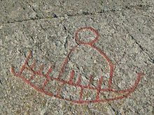
- Madsebakke. Above Sandvig, on the cycle path to Allinge, there is a collection of rock carvings or rock carvings (helleristninger), which is considered to be the largest collection of such rock carvings from the Bronze Age in Denmark. The wheels, ships, foot outlines etc. have been traced in red so that they are easily recognizable. The rock slabs are freely accessible.
activities

- Lido. With complete equipment: beach supervision, changing rooms, showers and toilets.
- hikes. You can hike short and long tours around and across the Hammerknuden as you wish, but a really worthwhile tour is the circuit of the Hammerknuden, which also offers minor challenges due to the sometimes stony, narrow paths and frequent headwinds. The route is part of the coastal footpath that goes around Bornholm.
- Around the Hammerknuden. The starting point for the hiking trail marked with yellow dots (approx. 2 hours) is the parking lot at the lido or campsite, from where you take the asphalt path to the beacon Hammerodde Fyr goes. From the lighthouse, the route continues on narrower paths, on which there are occasional heels or larger bumps to be overcome. Shortly afterwards there is an artificially created boat entrance in the rocks on the shore, but today it is no longer advisable to use it. You walk on and you come to the remains ofSolomon's Chapel, a chapel from the 14th century. Shortly afterwards you can decide to take the further path along the coast to Hammerhavn, or to climb up the slope to the left to the highest point of the Hammeren. There, at a height of 82 m, you will find the 21 m high lighthouse, which was built in 1872 and ceased to operate in 1990. The lighthouse cannot be visited. The natural rock bridge follows on the hiking trail on the coast Kælderhals and the Congestolebefore going to a parking lot Hammerhavn reached, a port that was built at the end of the 19th century for the removal of the granite quarried in the Hammeren quarries. From here you can take a boat tour. The way back to Sandvig runs around the Opal lake, which was built in a former quarry, and on Hammersø which emerged from a natural ravine that separates Hammerknuden from the rest of the island. The circular route ends at the parking lot on the beach.
 Solomon's Chapel
 Slottslyngen
 - Slottslyngen (Schlossheide). Hikes in Slottslyngen are possible from Vang harbor (bus stop), Hammershus (bus stop) or Mølledalen. There is also a yellow-marked hiking trail that leads from the fortress through Mølledal, then along the coast to Finnedalshuset (near Vang), then across Slottslyngen to Troldsbjerg and finally through Paradisdalen back to the starting point. This route is not only very attractive when the heather is in bloom, but requires a certain surefootedness.


shop
kitchen

- 1 Ella's Restaurant & Pastry Shop, Strandgate 42. Tel.: 45 56 48 03 29, Email: [email protected]. Long-established, well-kept restaurant and cafe in a typical cozy Sandviger house with museum-like furnishings and paintings, but with fine cuisine and delicious cakes, and also with the typical Danish apple pie: A bowl with cake crumbs, sweet apple compote on top and a layer of whipped cream on top.
accommodation
Cheap
- 1 Sandvig family camping, Sand lines 5, 3770 Allinge / Sandvig. Tel.: 45 56 48 04 47, Email: [email protected]. Directly below or on the slope of the Hammerknuden, with huts, washing machines, a small shop, cooking facilities and covered seating. Family-friendly with a playground, jumping pillows and family washrooms. Free WiFi in the reception.
- 2 Sandvig Vandrerhjem "Sjøljan", Hammershusvej 94, 3770 Sandvig. Tel.: 45 56 48 03 62, Fax: 45 56 48 18 62.
medium
security
fire Department 112
Ambulance 1813
The Bornholm Police Department is based in Rønne, Tel. 45 56 90 14 48.
health
The hospital from Bornholm, tel. 45 56 95 11 65, is located in Rønne.
Practical advice
There is no longer any tourist information in Sandvig. The nearest tourist information is located in Allinge.

trips
- Boat trips along the Hammerhavn coast
- Moseløkke. Granite quarry with the possibility of carving stones yourself.
- Next to the neighboring towns Allinge and Hasle At least motorists can reach all places Bornholms after mostly a short drive, so that holidaymakers can actually visit the whole island from Sandvig.
literature
Web links
- An official website is not known.