The scottish highlands lie in the northwestern part Scotland. The area described here includes the administrative districts Highland as Argyll and Bute, but without the islands (these see Inner Hebrides). It borders the to the southeast Central lowland belt and in the east North East Scotland. In the west lies the Atlantic with the islands of the Hebrides and to the north the Orkney and, further away, the Shetland Islands.

Regions
- Argyll and Bute - Landscape in the southwest with deeply cut fjords and numerous islands
- Central Highlands - sparsely populated bush and treeless wilderness with elongated ones Glens (Valleys), Lochs (Lakes) and mountains
- Northwest Highlands - Almost unpopulated bush and treeless wilderness northwest of the Great Glen, due to the distance to more densely populated areas the form of solitude
- Cairngorms - Mountain range in the east of the Highlands
places
- 1 Inverness (65,000 inhabitants), transport hub, administrative capital and economic center of the Highlands, which almost every Highland visitor visits. The local population also flocks here to, for example, choose bathroom tiles, have a new clutch installed for the Land Rover or deal with passport issues.
- 2 Fort William (10,000 inhabitants) is the largest city on the west coast of the Highlands and describes itself because of its proximity to the mountains around Ben Nevis (Great Britain's highest mountain) and Glencoe as Outdoor Capital of the UK.
- 3 Oban (9,000 inhabitants) is the main ferry port to the Hebrides.
- 4 Thurso (7,000 inhabitants) is the northernmost notable place on the Scottish mainland. From nearby Scrabster the ferry puts on the Orkney Islands from.
- 5 Invergordon - Deep sea port on a fjord with a naval base and shipyard for drilling platforms
- 6 Aviemore - (3,000 inhabitants) Gateway to the Cairngorms
- 7 Ullapool (2,000 inhabitants) in the northwest is a major fishing port and ferry port to the Outer Hebrides.
- 8 Golspie (1,500 inhabitants) - main town of Sutherland with the fairytale castle Dunrobin Castle
Other goals

- 1 Loch Ness - due to the myth, the most visited part of the Highlands, but by far not the most spectacular part of the landscape
- 9 Glencoe - The valley surrounded by rugged mountains with its tragic history of the Glencoe massacre is a magnet for domestic and foreign tourists.
- 2 Ben Nevis - At 1,345 m, the highest mountain in Great Britain and a popular hiking destination
- 3 Torridon - Sandstone Mountains with their majestic mountains
- 4 Assynt - the varied landscape and geology of Assynt with the North West Highlands Geopark
- 5 Applecross Peninsula, accessible via a spectacular mountain pass
background
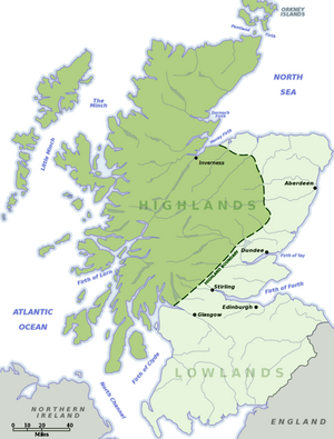
The term Highlands is ambiguous and is used in different ways. The name is common for the northern part of Scotland, which is characterized by its relatively high mountains, lack of agricultural cultivation and sparse settlement. In this context stands Highlands in contrast to the Lowlands or. Borders further south of Scotland. To subdivide Scotland, the name is used here Highlands used in this sense.
The Highland County is by far the largest and most sparsely populated district in Scotland. It covers about a third of the area of Scotland and ranges from about Glencoe in the south and the district administration in Inverness in the east to the western and northern coasts. The island Skye is also part of it.
Geologically and spatially, a fracture zone borders the Highland Boundary Fault the highlands in the northwest from the central lowlands in the southeast. The fracture zone runs in an almost straight line from the northern tip of the island Arran across the island Bute through the Firth of Clyde, Dunoon, Helensburgh, the southern Loch Lomond, Aberfoyle, Callander, Crieff, Dark and meets north of Stonehaven the North Sea. It is particularly recognizable in the area from Loch Lomond to Dunkeld by the striking mountains in the area.
The whiskey distillers have a different definition of their whiskey regions Highland, Lowland and Strathspey.
history
The Highlands were formerly ruled by a population of Celtic and Scandinavian origins. By the end of the 14th century, a patriarchal clan structure had developed. The individual clans were led by clan chiefs and lived self-sufficient in their ancestral areas. There were always armed conflicts, both between the clans and with the feudalist rulers of the Lowlands from the House of Stuart. However, the feudal system of the Lowlands gradually established itself in the Highlands, partly politically and partly militarily. At the end of the 16th century, the Stuarts could count on the loyalty of most of the clan chiefs.
After the unification of the English and Scottish kingdoms and the establishment of the English claim to leadership, there were repeated quarrels with the clans, the majority of which were on the side of the Stuarts. During the two Jacobite uprisings of 1715 under the leadership of James Francis Edward Stuart and 1745 under Bonnie Prince Charlie, the fighters of the clans from the Highlands contributed decisively to the fighting strength of the insurgents. With the suppression of the uprisings, the decline of the clan structures was sealed. Until then, the largest possible population counted as a sign of the power of the clan chiefs (and a resource for the armed forces), now it was about rental income. The clan chiefs also claimed previously communal land as private property. Even today, the entire Highlands are distributed among around 500 landowners (Estates).
The barren land did not produce much, extensive pasture farming promised higher yields. This resulted in large parts of the former clan population being evicted from their ancestral territories in the late 18th and 19th centuries, the infamous Highland Clearances. There was a wave of emigration to North America and Australia. The Gaelic language, which had been widespread in the Highlands until then, was largely extinct. Even today, large parts of the Highlands, especially in the northwest, are extremely sparsely populated. In the 19th century, red deer displaced the sheep, hunting leases brought in even more and numerous hunting castles were built in remote valleys.
Landscape picture
Large parts of the highlands were glaciated during the last ice age, the glaciers formed the wide valleys with the steep flanks (often called U valleys designated). The mountains looked out of the ice, they often form extensive plateaus from which individual peaks look out more or less prominently. The higher altitudes were never forested, the tree line is 600 to 800 m, but lower-lying areas were almost completely covered with trees with a particular distribution of white pine ("Scots Pine"). Agriculture was limited to the valley floors. Today's traveler quickly overlooks the fact that the landscape, which appears so primeval, is heavily influenced by human activity. The forests were raw material for shipbuilding and pit timber and were cut down almost everywhere, later people were driven out for pasture farming. And in the 20th century, numerous artificial lakes were created (or natural lakes enlarged by damming) to generate hydropower. Today's reforestation is mostly profit-driven, i.e. cultivated to a certain extent like perennial fields and left fallow after the "harvest" and does not contribute to the beautification of the landscape.
language
The population speaks continuously English. However, since the beginning of the Scottish Devolution Gaelic is also once again the official language spoken by some people in the far north and west of the region. In addition, most of the place names and other geographical names in this region are derived from Gaelic.
getting there
The only commercial airport with international connections (there was one to Amsterdam in 2021) is the Inverness Airport![]()
![]()
![]() (IATA: INV). From Glasgow Airport
(IATA: INV). From Glasgow Airport![]()
![]()
![]() (IATA: GLA) as well as the Edinburgh Airport
(IATA: GLA) as well as the Edinburgh Airport![]()
![]()
![]() (IATA: EDI) you need at least one hour, more likely two to three, to the more remote corners it can be a (half) day trip.
(IATA: EDI) you need at least one hour, more likely two to three, to the more remote corners it can be a (half) day trip.


Rail lines come from Glasgow on the west coast (West Highland Line) to Fort William and Mallaig, Ferry terminal to Skye and from the south (Perth via Inverness (North Highland Line) and further north to Thurso and Ferry Ports Wick or after Kyle of Lochalsh. Another railway line leads from Aberdeen from the east to Inverness.
The most important road connections to the Highlands are the four-lane roads ![]() from Edinburgh to Inverness and the
from Edinburgh to Inverness and the ![]() from Glasgow via Fort William to Inverness. Away from the main roads, the roads are often narrow, winding and last but not least (for some Scotland only begins there) single-lane, so-called. single track roads. Rapid progress is then no longer to be expected.
from Glasgow via Fort William to Inverness. Away from the main roads, the roads are often narrow, winding and last but not least (for some Scotland only begins there) single-lane, so-called. single track roads. Rapid progress is then no longer to be expected.
Invergordon and, more rarely, Fort William, are visited by cruise ships. There are ferry services to the Hebrides, Orkney and Shetland Islands.
mobility

In line with the low population density, the public transport network is also rather sparsely developed. There are only a few train connections. Buses only rarely run off the main routes, often it is the Postbus that takes a few paying passengers in the back seat - also a way to get to know the country and its people. But fast is different.
Realistically, the visitor will be traveling by car. The roads are well developed and, with a few exceptions, are able to cope with the volume of traffic. There are only a few petrol stations, especially on Sundays, when the tank is half full you should think about refilling.
Tourist Attractions
.jpg/300px-Rainy_day_(43949922082).jpg)
The first attraction is nature. Whether mountains, valleys, lakes, bays, coast, the light, it is varied. Then there is the wilderness of the uncultivated landscape, the distance from civilization. There are areas of the Highlands that, although located on the British main island, can only be reached by water, apart from the occasional day-long hike. It is all the more impressive how people struggled for their livelihood in this wilderness - evidence of settlement goes back to the Stone Age.

- Brochs - Residential and defense towers from the Iron Age are particularly widespread in the far north, Caithness and Sutherland (as well as on the Orkney and Shetland Islands). But they can also be found in various other areas of the Highlands.
- Castles - Fortified castles, especially from the times when the sword rather than the firstborn decided the inheritance of titles and power, are widespread all over the Highlands, accompanied by more or less bloodthirsty heroic sagas, ghosts and real crowns. Corresponding to its strategic importance, often in a spectacularly scenic location. Today many ruins, sometimes rebuilt or rebuilt as an aristocratic residence, museum or hotel. Examples:
- Mingary Castle on Ardnamurchan, ruin
- Castle of Mey in Caithness, rebuilt as the Queen Mum's dacha
- Eilean Donan Castle on Loch Shiel, rebuilt as a museum
- Castle Tioram on an island in Loch Moidart, ruin
- Urquhart Castle on Loch Ness, ruin, suitable foreground for Nessie sightings
- Castles - Some families of the large estates afforded themselves opulent palaces, often in extensive parks, which show what can grow in this climate if you let enough gardeners around. Some plants, such as the rhododendron, expanded enormously and now cover half the slope - a colorful sight at the time of flowering
- Dunrobin Castle of the Dukes of Sutherland at Golspie
- Inveraray Castle of the Dukes of Argyll in Inveraray
- Blair Castle of the Dukes of Atholl in Atholl
- Skibo Castle, rebuilt by the Scottish / American industrialist Andrew Carnegie near Dornoch
Only park are they Inverewe Gardens, a botanical landscape garden near Gairloch.
- Technology and infrastructure - The systematic development of the highlands with a road network for the military began especially since the suppression of the Jacobite revolt. Later came the railroad and the modern road network. The abundance of water is used with an extensive network of reservoirs and hydropower plants.
- Bonawe Furnace - iron smelting from the 18th century
- Caledonian Canal, a 97 km long waterway from the east to the west coast of Scotland, can be admired today as a technical achievement of its time (completed in 1822) with 29 locks.
- West Highland Railway, railway line near the west coast
- Loch Mullardoch - largest dam, 50 m high
activities

Hiking and mountaineering
The Highlands offer an almost inexhaustible range of short walks to challenging mountaineering ventures. Although the absolute height of the mountains with a maximum of 1345 m (Ben Nevis) does not seem too impressive at first glance, one should not make the mistake of measuring them against alpine standards. Due to the climate and the northerly location, the mountains of the Highlands can be compared with alpine regions approx. 1200 m higher. The tree line here is around 600 m above sea level. The rapid change in weather and the remoteness of many areas make day trips a serious undertaking. Weatherproof clothing, sturdy and waterproof footwear, gaiters and, if necessary, winter equipment are essential even on shorter tours. A map, GPS and a backup compass are compulsory for orientation (some mountains have magnetic rocks that can irritate the compass - make sure you know beforehand. Hikers who are on the move away from marked routes regularly get in an emergency as a result - it is best to ask locals beforehand and always leave your route plan at the start. The purple ones are usually sufficient for hikes Ranger Maps on a scale of 1: 50,000. They are available from almost all tourist information centers, and in more remote areas sometimes also from grocery stores or petrol stations.
The quality of the paths varies greatly. While in the Glens (Valleys) often still find drivable farm roads, one can sometimes only guess the path at a higher altitude. However, when visibility is good, it is not a problem to make good progress even in unpaved terrain. On the extensive wet meadows and on sometimes rather muddy slopes and when crossing streams, sturdy and waterproof footwear (or Crocs) pays off.
At higher altitudes you shouldn't let the weather out of your sight. Clouds, rain and fog can come up within a short period of time and make orientation very difficult, especially in pathless terrain. A compass can save you from the worst. The frequent cold and strong winds on mountain ridges can be more than uncomfortable.
Some, including locals, go on mountain hikes like collecting stamps. There are lists of the
- Munros, Premier class of mountains over 3000 ft (914 m). Compiled for the first time by a Sir Hugh Munro in the late 19th century, these are currently 282 peaks (the delimitation of what is an independent peak and what is secondary peaks of a higher massif is somewhat arbitrary and also changes occasionally. The number also changes vary). With one exception, all Munros, including the occasional scramble, can be reached on at least one route without mountaineering aids. A particular challenge are difficult-to-access Munros, which sometimes require an ascent of several kilometers through lonely terrain.
- Corbett's, the second division. These are mountains between 2,500 and 2,999 ft and at least 500 ft high, currently 221.
- Grahams, Third division: All mountains between 2,000 and 2,449 ft and 150 m (492 ft) high, currently also 221 in number
- Marilyns are all mountains with a notch height of 150m, regardless of their absolute height. That is (as of 2020) 2,011 mountains
In the numerous nature parks in particular, the signs posted at the hiking car parks should be followed. At certain times of the year, for example, to protect game, it is forbidden to leave the marked trails.
On days with high humidity or after dusk, the small black mosquitoes (midges) become the dominant plague in many places. Spending the night outdoors (without a tent) is strongly discouraged. The locals of Cannich According to the "Midges" avoid the smell of yeast in the air. Accordingly, the consumption of yeast in the form of yeast tablets, Marmite, Vegemite (as a spread, recommended with salted butter) help preventively. Furthermore, the mosquitoes mentioned avoid sun, wind and heavy rain.
Weblinks:
- http://www.smc.org.uk/ - Scottish Mountaineering Club (English).
- http://www.jmt.org/ - Nature conservation organization John Miur Trust (English).
kitchen
The clootie dumpling pudding is the national dish and dessert.
nightlife
security

The Highlands have negligible crime statistics. The further you get from the few cities, the greater the likelihood of finding unlocked front doors. The only appropriate safety tip concerns the well-known parking spaces from which mountain hikers start their tours: It is advisable not to leave valuables visible in the car or, even better, not to bring them with you in the first place.
Even if the Scottish mountains do not impress at the absolute height, you should always pay attention to weatherproof equipment, sturdy hiking boots, emergency supplies and a map and compass when hiking in the mountains. The exposed location to the Atlantic storms, rapid weather changes and the extremely thin settlement, lack of infrastructure and cell phone gaps harbor risks, the underestimation of which can be fatal and does so year after year. In the mountains, on the one hand, storms on the high peaks, but also fog and the loss of orientation in the trackless area are the greatest dangers.
climate
It is widely believed that it rains in the Highlands constantly. This is wrong both quantitatively and qualitatively. The amount of rain is rather average for Central to Northern Europe, and precipitation usually only lasts for a short time due to the typically strong westerly winds. But they can also appear on the horizon at short notice, so weatherproof clothing is always advisable on excursions into the mountains. The Mountain Weather Information Service offers daily updated weather information for different regions of the Highlands, the URL http://www.mwis.org.uk/mobile is specially designed for access while on the move with internet-enabled cell phones.
trips
literature
Web links
- The Highland Council (Comhairle na Gaidhealtachd)
- Walkhighlands describes numerous hikes of varying degrees of difficulty