The lower Zschopautal is the area around the river Zschopau north of the Ore Mountains. The mouth of the Flöha in the south can be used as a demarcation; in the north the Zschopau flows into the Freiberg Mulde.

places

The largest and most worth seeing places downstream:
- 1 Lichtenwalde


 in the Wikidata database") - Niederwiesa district with castle and baroque garden. A small clock museum in the castle.
- Niederwiesa district with castle and baroque garden. A small clock museum in the castle. - 2 Frankenberg
 - this is where the "Barkas" was built in the GDR. After the "turnaround" and the related cessation of production, the vehicle museum in Frankenberg was set up.
 - 3 Mittweida - Evangelical Lutheran City Church “Our dear women”.
- 4 Waldheim - Worth seeing Art Nouveau town hall directly on the Zschopau, correctional facility with church and museum.
- 5 Hartha - the city is not located directly in the Zschopau valley, but around 4 km to the west; Neo-Romanesque town church and museum for industrial history.
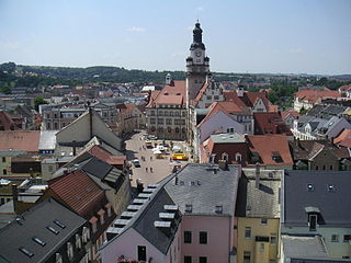
- 6 Chub - at the confluence of the Zschopau in the Freiberg Mulde; very beautiful city center: renovated because the flood in 2002 was up to 2 m in the city; very nice theater.


Upstream places are the region Zschopautal assigned.

Other goals

- Kriebstein dam
background
getting there
By train
- Hourly regional train off Chemnitz and Riesa (every two hours from Elsterwerda) runs parallel to Zschopau, with stops in Mittweida, Erlau, Schweikershain, Waldheim, Steina, Limmritz, Döbeln (travel time from Chemnitz 15–35 minutes; from Riesa 20–45 minutes). Regional trains stop every hour in Döbeln Leipzig (Travel time 1:10 hours). Transition from long-distance traffic is possible in Leipzig and Riesa.
- The City-Bahn Chemnitz (a tram-train, i.e. a mix of tram and train) line C15 stops every hour on its way to Hainichen in Niederwiesa, Braunsdorf-Lichtenwalde and Frankenberg (journey time from Chemnitz Hbf 10-20 minutes)
- City-Bahn line C14 runs every hour from Chemnitz to Oberlichtenau and Mittweida (10-20 minutes from Chemnitz main station)
By bus
- You can take bus 640 from Chemnitz every hour to Lichtenwalde, Auerswalde and Frankenberg (travel time from Chemnitz bus station is 20-30 minutes).
- Bus line 750 leaves every hour Freiberg above Nossen to Döbeln (Nossen – Döbeln 35 minutes; Freiberg – Döbeln 1:10 hours).
In the street
The A4 motorway (Dresden – Erfurt), junction, runs through the lower Zschopau valley in the south Chemnitz-East or Frankenberg. The northern end of the Zschopau valley, on the other hand, is easier to reach via the A14 (Leipzig – Dresden), junction Döbeln-North. The connection between the two is provided by the federal highway B169 (Chemnitz – Hainichen – Döbeln).
By bicycle
- On the Muldental cycle path (Freiberger Mulde section) from Freiberg and Nossen or in the opposite direction from Grimma, Colditz and Leisnig to Döbeln (and then continue on the Zschopautal cycle path upstream)
- On the Germany route D4 (Mittelland route) or Saxon city route from Dresden, Freiberg, Chemnitz or Gera to Erdmannsdorf (at Augustusburg) and then on the Zschopautal cycle path downstream
On foot
The leads through the lower Zschopau valley Luther Trail Saxony, on which pilgrims and long-distance hikers and others from Grimma, Rochlitz, Torgau or Zwickau.
mobility
The region of the Lower Zschopau Valley belongs to the network area of the Verkehrsverbund Mittelachsen (VMS). Association tickets with the corresponding tariff zones are valid on all means of transport. The Saxony (Saxony-Anhalt, Thuringia) ticket is also valid on all VMS means of transport.
- The Regional train-Line Chemnitz-Riesa runs largely parallel to Zschopau and stops every hour in Mittweida, Erlau, Schweikershain, Waldheim, Steina, Limmritz and Döbeln.
- Line C14 of the City train Chemnitz (hourly) between Oberlichtenau and Mittweida (via Ottendorf and Altmittweida)
- buses, e.g. B line 675 Frankenberg – Mittweida (at least every hour on weekdays)
- The leads along the Zschopau Zschopautal cycle path (63 km from Erdmannsdorf near Augustusburg to Döbeln).
- Hiking along the Zschopautal hiking trail (a total of almost 50 km from Niederwiesa to Döbeln)
Tourist Attractions

- Kriebstein Castle south of Waldheim is one of the best preserved and therefore most beautiful knight castles in Germany. Its location in the picturesque Zschopau valley is what gives it its unique charm. First mentioned in a document in 1384, the Gothic complex has largely retained its Gothic character. The Kriebsteinzimmer - a uniquely preserved plank room around 1425. The unique wall paintings in the castle chapel, rediscovered after the war, date from around 1410. The castle tavern "Zum Hungerturm" has been inviting people to take a snack since 2006. The recreation area Kriebsteintalsperre is only 1400m away from the castle.
- The closest train station is Waldheim (4.5 km). From there you can hike to the castle or take your bike along the Zschopautal cycle path. This leads directly past the castle. There is a bus stop 500 meters from the castle, but buses only stop there a few times a day (Mon-Fri: Bus 678 from Mittweida, 2x in the morning, 2x in the afternoon; Sat-Sun and public holidays: Bus 642 from Chemnitz via Mittweida, im Every two hours).
- Bankruptcy mile: Section Waldheim – Limmritz of the Chemnitz – Riesa railway line with six viaducts and the largest dry retaining wall on a railway line in Europe. The high construction costs led to the insolvency (and subsequent nationalization) of the Chemnitz-Riesaer Eisenbahn-Gesellschaft in 1848. Scenic route for walking (approx. 8 km).
activities
kitchen
nightlife
security
climate
literature
- Cycling and hiking map for Döbeln, Nossen, Triebischtal and the surrounding area. Publishing house Dr. Barthel, ISBN 978-3-89591-030-2 . Scale 1: 50,000, € 4.90