| Utrecht (province) | |
 | |
Location 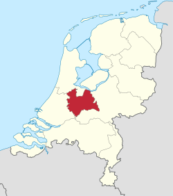 | |
Coat of arms and flag | |
| State | Netherlands |
|---|---|
| Capital | Utrecht |
| Surface | 1,449.12 km² |
| Inhabitants | 1.268.489 (2017) |
| Tourism site | |
| Institutional website | |
Utrecht province is the smallest of the provinces of the Netherlands, located in the central part western of the country.
To know
The province of Utrecht is a small, densely populated region whose western edges are partially included in the Randstad, the largest conurbation of the Netherlands which includes, among others, the cities of Rotterdam is The Hague.
Despite being a highly urbanized area, there is no shortage of green areas that are quite diversified from each other, such as the vegetable gardens and orchards of Betuwe (the good earth) and the sandy and uncultivated land of the Veluwe (the bad land) on the border with the Gelderland covered, on the other hand, by broad-leaved woods interspersed with heaths. North of capital there are the lakes of Vechtstreek and Loosdrechtse, important recreational areas where sailing is practiced in the summer.
Utrecht is by far the most visited city in the province, closely followed by Amersfoort. Also worth seeing is a series of castles and royal residences shown below.
Geographical notes
The province of Utrecht borders theNorth Holland and the Flevoland to the north, la Gelderland to the east and south and with theSouth Holland West.

The eastern part of the province is an area of woods interspersed with landscapes of small dunes formed by fluvial sediments. The area is crossed by a chain of low hills of morainic origin, the Utrechtse Heuvelrug, 50 km long. Due to these characteristics, the wealthiest families of Utrecht they preferred to move here since the nineteenth century. Zeist it is still the upmarket suburb of Utrecht, developed around a noble castle (Zeist slot) of the 17th century.

The south of the province is an area of marshes formed by numerous rivers and lazy-flowing arms of the Rhine including the Kromme Rijn (literally "crooked Rhine"). This branch of the Rhine, located further north than all the others, constituted a stretch of the Limes Roman, guarded by numerous forts of which traces have been found. Wijk bij Duurstede is the most touristic center in the south of the province. It seems that the name Wijk is derived from the Latin vicus.
The west consists mainly of flat meadows and landscapes. To the north are vast lakes formed by peat bogs after the last ice age.
The south of the province is an area of marshes formed by numerous rivers and lazy-flowing arms of the Rhine including the Kromme Rijn (literally "crooked Rhine"). This branch of the Rhine, located further north than all the others, constituted the Limes Rhenish, guarded by numerous forts of which traces have been found.
Background
In the Middle Ages, much of the area of the present province was ruled by the Bishop of Utrecht. The bishopric was founded in 722 by Willibrord. Many wars were fought between Utrecht and the neighboring counties and duchies of Holland, Gelderland is BrabantIn 1527, the bishop of Utrecht sold secular power over his territories to Emperor Charles V, who already owned the other Dutch provinces. However, the Habsburg rule did not last long, as Utrecht joined the revolt of the United Provinces against Charles's son, Philip II of Spain, in 1579.
Territories and tourist destinations
Urban centers
- Utrecht - Historic university city known for its grachten (channels).
- Amersfoort - Second center of the province by number of inhabitants, Amersfoort it boasts a pretty historic center still surrounded by moats, one of the most visited zoological gardens in the country and green surroundings to cycle around.
- Bunnik - Outskirts known mainly for a nightclub.
- Leerdam - Famous center of the dairy industry.
- Oudewater - A medieval village once known for its rope factories.
- Rhenen - Famous place for its zoological garden.
- Soest - With a thousand-year history, today a satellite city of Amersfoort.
- Veenendaal - Rather large town, mainly residential.
- Wijk bij Duurstede - Probably built on a Roman fort that guarded the northern border of the empire, Wijk bij Duurstede it is famous for an early medieval castle and a unique mill with an arched passage at its base.
- Woerden - Town with a modern cheese market.
- Zeist - High-class suburb of Utrecht surrounded by greenery and with the only attraction a castle, (Zeist slot) of the seventeenth century belonged to an (illegitimate) exponent of the house of Nassau.
Other destinations
- 1 Groene Hart - Agricultural green area between the provinces of Utrecht and that ofSouth Holland.
- 2 Utrechtse Heuvelrug National Park - A park on a series of low hills with wooded slopes rising amidst moorland landscapes.
How to get
How to get around
What see


- 1 Castle de Haar (Kasteel de Haar).


- 2 Zuylen Castle (Slot Zuylen).


- 3 Soestdijk Palace (Paleis Soestdijk). A former royal residence
- 4 Pyramid of Austerlitz (Pyramide van Austerlitz).
What to do
At the table
Safety
Other projects
 Wikipedia contains an entry concerning Utrecht (province)
 Commons contains images or other files on Utrecht (province)