| Val di Susa | |
 | |
Location 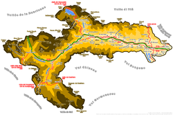 | |
| State | Italy |
|---|---|
| Region | Piedmont |
| Surface | 1,200 km² |
| Inhabitants | 95.581 |
| Tourism site | |
| Institutional website | |
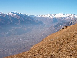
Susa Valley is an alpine valley ofPiedmontese Alps, in the province of Turin, on the border with the France and includes the basin of the Dora Riparia river.
To know
There are many tourist destinations in this area that connects Italy is France, some internationally renowned, such as Sestriere is Bardonecchia.
Always an important communication channel between the Mediterranean and north-western Europe, the Susa Valley has been crossed over the centuries by merchants, nobles, pilgrims, travelers, armies, but also by ideas and culture that have contributed to shape their civilization and have left lasting imprints on the landscape: Roman vestiges, fortifications and abbeys are the most evident signs of a rich past ...
A unique environment and a thousand-year history are the backdrop to hundreds of km of hiking, historical and cultural itineraries that allow you to grasp the true essence of the Susa Valley.
Geographical notes

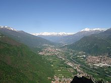

The Susa Valley is located in the Cozie and Graie Alps in Piedmont, between Turin and the French border. It is administratively divided into 37 municipalities. Many peaks in the Valley exceed the altitude of 3,000 meters: Mount Rocciamelone, with its 3,537 meters, is mistakenly considered the highest peak which, on the other hand, is the Roncia (3,612 m), in French territory. The third peak of the Susa valley is La Pierre Menue (3,507 m) followed by the Rognosa d'Etiache (3,382 m), Niblè (3,362 m), Ferrand (3,347 m), Sommeiller (3,333 m), Giusalet (3,313 m) mountains, Cresta San Michele (3,262 m), Bernauda (3,225 m), Vallonetto (3,217 m), Pic du Thabor (3,207 m), Thabor (3,178 m), Gran Vallone (3,171 m), Baldassarre (3,164 m), Cima di Bard (3,150 m), La Gardiola (3,138 m), Chaberton (3,136 m), Punta Bagnà (3,129 m), Punta Nera (3,047 m) and Grand Argentier (3,042 m). Also of interest is the Ambin massif, which while insisting in France, southwest of the Mont Cenis hill (orographic right), is easily reachable from the Valsusine side, the massif is composed of the Rocca d'Ambin (3,378 m), three Denti d'Amin (3,372m, 3,353m and 3,365m), Rochers Penibles (3,352m), Mont Ambin (3,264m), Gros Muttet (3,243m), Punta dell'Agnello (3,187m) and Rochers Clery (3,145m ), There are also three regional natural parks in the area: the Avigliana Lakes Natural Park, the Orsiera-Rocciavrè Natural Park and the Gran Bosco di Salbertrand Natural ParkThe Susa Valley is connected with the Savoy through the Mont Cenis pass and other minor passes and through the Frejus tunnel, while the connections with the ancient Dauphiné are guaranteed by the Montgenèvre and Scala passes. this area is crossed every year by about four million vehicles, mostly directed towards France and towards the tourist reception areas located in the upper valley. made sure that the Susa Valley has acquired a large hotel accommodation capacity over time, and has recorded, in the last three years, a consistent presence of both Italian and foreign tourists. orographic characteristics, over the centuries it has played an important role in the events that led to the birth of Europe as a continental and cultural entity.
When to go
The Susa Valley can be visited in all seasons. In winter for skiing, alpine or Nordic. In spring on weekends thanks to the events of GustoValsusa and to those organized by local authorities, which then continue in the autumn with a rich calendar. In summer, there is no shortage of possibilities for hiking or mountain parties. Furthermore, in any season it is possible to visit the rich cultural heritage of the valley.
Background
The appearance of man in the territory of the Susa Valley and the formation of the first settlements of a certain importance take place between the middle and the end of the fifth millennium BC, as evidenced by the Neolithic sites of Maddalena and S. Valeriano. In the third millennium BC we witnessed the gradual transition towards the Bronze Age, at the end of which the first sporadic use of the Mont Cenis and Montgenèvre passes probably had to begin.
Starting from the sixth century a. C. onwards there were the first invasions of the Gallic populations. A few centuries later, the Valsusina area and the Turin plain near the entrance to the Alpine valleys was inhabited by the Taurini, a people of Ligurian origin, but with cultural elements of Celtic influence, settled in mountain or subalpine settlements already founded before Gallic population of the plain.
In the 2nd century BC the Roman occupation of Piedmont began, operated in different ways depending on the populations with which via Roma came into contact. The Cozian populations, settled in the Susa Valley, chose the path of friendship with the new power, stipulating a "foedus" that allowed them a gradual integration into Roman times. As evidence of the stipulated pact, the arch of Augustus was erected in Susa in 13 BC. The Romans also imposed on Cozio the arrangement of the Alpine transit routes, through the construction of the Roman road of the Gauls on the site of the previous Celtic track. After the Cozian settlement, the Valsusina road that led through Montgenèvre became a mainstay of communications between Italy, Gaul and the Rhine area.
Starting from the 3rd century AD. also the Susa Valley and the Turin area were affected by the generalized crisis that hit the Empire. At the beginning of the fifth century, then, the western subalpine region was affected by important military events: between 400 and 410 we witnessed the invasions of the Visigoths, the Ostrogoths and the fighting imperial armies. Precisely in this period, the control of the Valsusine passes was taken over by the Bagaude population, mostly made up of gangs of peasants and dispossessed who made raids from Gaul in the area of Provence and Turin.
At the end of the sixth century, the entire area of Turin fell under the domination of the Lombards, who conquered Turin in 570, while the Franks settled on the border of the Alps. The convergent region on Lombard Turin was marked by this proximity. Twice in the eighth century, before the definitive invasion, the Frankish armies had defeated the Lombard ones, but above all for some time the Franks had settled in the Susa Valley: the foundation of the Novalesa abbey by Abo, a Merovingian nobleman, an official of the Frankish kingdom; it is in the lower Susa Valley, probably in the area between Caprie and Chiusa San Michele, that the defensive system of the locks was built, a series of complex fortifications that yielded in 773, leaving the way to Charlemagne.
Between 921 and 972 the Saracens were a constant presence on the passes and on the alpine routes and at the beginning of this phase there are the devastations of Novalesa and the plain of Oulx, which saw the escape of the novaliciensi monks and a strong contraction of the settlements , especially in the upper valley.
Between 940 and 945 the military actions of Arduino il Glabro, Marquis of Turin intensified, leading to the liberation of the Susa Valley and its passes from raids and banditry. Arduino was succeeded by his eldest son Manfredo and the latter's son, Olderico Manfredi, founder of the abbey of San Giusto di Susa (1029) and father of Countess Adelaide. It became the de facto heir to the Marca di Torino, which became a domination to whose owner the emperor delegated control of the main Alpine pass, the Mont Cenis. Adelaide had three marriages, the last of which, with Odo of Moriana, allowed the House of Savoy the fundamental crossing of the Alps.
Although not personally retaining the marquis title, Adelaide kept the de facto power in her hands until her death in 1091. The arduinici kept in Turin, the episcopal seat and official capital of the district, the center of their power, focusing elsewhere on roots stately. The Susa valley was one of these places, which later served to the Savoy to present themselves as the most accredited pretenders to the succession of Adelaide. They made the valley the only base of dominion on this side of the Alps for the entire course of the twelfth century and beyond.
At the same time, the Counts of Albon - future Dolphins - a family originally from Burgundy like the Savoy and also interested in the control of the alpine passes. In this area they already found a certain organization: the different communities had in fact used to meet for some time, essentially to discuss the distribution of taxes and defense costs of the territory (old French escartonner).
In the Briançonese area there were five escartons: Oulx, Casteldelfino, Pragelato, Château Queyras and Briançon, who decided to group together, forming the assembly of the great Brianzonese escarton.
In 1349 the Dauphin Umberto II, found himself without heirs and in a disastrous financial situation, decided to donate his possessions to the heir of the king of France and to retire to a convent.
On the Savoy front, the situation was no less complex. After an initial phase of dynastic struggles, Adelaide's successors strengthened their noble power over the lands from Mont Cenis to the lower Susa valley and on Valle d'Aosta, overcoming the resistance of some secular and religious powers. With Umberto III the Blessed (1148-1189) they consolidated their presence and obtained imperial favor.
The Savoy expansionist policy achieved new and notable successes with Thomas I (1189-1233), who also managed to obtain the title of vicarius totius Italiae from Emperor Frederick II. During the thirteenth century there were violent conflicts between the main branch of the family and the Savoy Acaja, resolved with a division between the Piedmontese territories that remained under the direct jurisdiction of the county of Savoy (the Susa valley), and those that entered to make part of a first nucleus of autonomous piedmont domain, which lasted until 1418.
The temporary end of the dynastic struggles led to a period of prosperity, in which the reforms carried out by Amedeo V were also placed. On the death of Amedeo V there were some decades of political stasis, while from the second half of the fourteenth century there was a period of new, strong expansion, experienced thanks to the shrewd governments of Amedeo VI, called the Green Count (1343-1383), Amedeo VII (1383-1391), the Red Count and Amedeo VIII (1391-1451).
The domain was restructured and centered on two capitals, Turin and Chambéry. In this period the Counts of Savoy obtained the recognition of the ducal title, granted by the Emperor Sigismund in 1416. The first signs of crisis appeared starting from 1434, when Amedeo VIII - who was elected antipope with the name of Felix V - he retired to his castle of Ripaille on Lake Geneva, leaving the government to his son Ludovico (1434-1465). The slow decline stopped only with Emanuele Filiberto in the second half of the sixteenth century.
From 1536 the French occupation began, which lasted until 1559. For the Susa Valley, subject to the continuous transit of the fighting armies, it was a period of extreme difficulty. In the same period, in fact, we witnessed the emergence of religious struggles. Already from the thirteenth century the Waldensian presence was significantly attested in the Pragelato valley and, to a lesser extent, in the upper Val di Susa. In 1532 the Waldensians adhered to the reform and, gradually, the itinerant preachers were replaced by married shepherds and settled permanently in a specific place. From this moment on, thanks also to the preaching of some of Calvin's collaborators who came from Geneva, the populations of the upper Chisone Valley and part of those of the upper Susa Valley joined the Calvinist reform en masse. The reaction of the French government was not long in coming: in the years 1555-1560 in the Parliament of Grenoble the first heretics were judged, condemned to the stake.
The late sixteenth century saw the succession of eight wars of religion (1562-1590), which had as undisputed protagonists François de Bonne, Duke of Lesdiguières and head of the Huguenot party, and Jean Arlaud called La Cazette, head of the Catholic party, up to that the latter was killed in 1591 by the assassins of Lesdiguiéres.
The Edict of Nantes, signed in 1598, put an end to religious struggles, granting freedom of worship for the reformed. However, its revocation by King Louis XIV in 1685 brought chaos back to the valleys: ministers of worship were expelled, public meetings banned and temples razed to the ground. The reformers of the Dauphiné and those coming from the territories of the Duke of Savoy were forced into exile from their lands in Geneva and Prangins, on Lake Geneva, but in 1688 they decided to try to return: led by Henri Arnaud they retraced the journey backwards, returning armed at home.
The ups and downs linked to the War of the Spanish Succession led to the Piedmontese victory and the signing of the Treaty of Utrecht of 1713, with which the upper Susa Valley was reunited with the lower one, thus becoming part of the Duchy of Savoy and then of the kingdom of Sardinia.
However, the annexation of the upper Susa Valley was not painless: most of the local populations more or less openly opposed the transition from France to the Savoy kingdom, prompting the French to attempt to reconquer the lost territories several times.
The most significant clash occurred during the war of the Austrian succession (1742-1748) when in 1747, in the memorable battle of Assietta, 7,400 Piedmontese soldiers, after an epic resistance, managed to get the better of 20,000 men of the army French with a historic victory.
During the French Revolution and the Napoleonic period the Valsusian territory was again involved in war events. The reorganization of the Montgenèvre road and the construction of the current Mont Cenis road date back to this period.
The mid-nineteenth century saw the intensification of tourist and commercial transit through the valley, primarily thanks to the construction of the railway. The first section, which connected Turin to Susa, was inaugurated in 1854; three years later the works for the Bussoleno-Bardonecchia section and for the Fréjus tunnel were started, which was inaugurated in 1871. Precisely due to the slowness of the works for the Fréjus tunnel it was decided to temporarily provide a rapid connection between the Susa valley and the Maurienne: between 1866 and 1868 the Fell railway was built that connected Susa and Saint Michel de Maurienne through the Mont Cenis pass, which however remained in operation for only three years, being dismantled when the tunnel.
The military presence also intensified in the second half of the nineteenth century, when the high military commands began to take particular interest in the areas of Claviere and Mont Cenis following the tightening of relations with France. After 1860, with the cession of Savoy to France, the construction of the new defensive system began on the Mont Cenis hill, which became a border place. At the end of the 19th century, Mount Chaberton, which overlooks the towns of Cesana and Claviere, was considered the most suitable place to build a fortified system, whose construction was started in 1898. Immediately after the proclamation of Italy's intervention in the World War II (11 June 1940) one of the nerve centers of the conflict turned out to be the area of the Italian-French border. On 21 June the French, having gone on the counterattack, destroyed six of the eight turrets with which the fort was equipped with their artillery, on which the guns were positioned, compromising their use forever. With the signing of the peace treaty of 1947 the borders between Italy and France were revised: the Chaberton and the Monginevro plain were included in the French territory, while the town of Claviere should have remained entirely in Italy: in reality, until 1973 the dividing line cut the municipality in two. Finally, the Mont Cenis territory was also ceded to France by setting the border at the entrance to the plain of San Nicolao.
Spoken languages
In addition to Italian, the use of Piedmontese is widespread in the Susa Valley. Furthermore, in the villages the elderly speak dialects belonging to the linguistic area of Occitan on the right side, to the Franco-Provençal one on the left.
Culture and traditions
There are many traditions still alive in this Alpine area. For example, on the occasion of the patronal feasts, the central part of the Susa Valley and the Valcenischia come alive with ancient rites - perhaps of pre-Christian origin and then absorbed into the Catholic tradition - very interesting to see. In Chiomonte, on the occasion of S. Sebastiano is made to dance a high ovoid-shaped structure, called Puento. In Giaglione, San Giorio and Venaus, on the occasion of the two patronal feasts (respectively S. Vincenzo, S. Giorio and S. Biagio-S. Agata), you can watch the symbolic dance of swords performed by warriors with flowered headdresses, called Spadonari. They are accompanied by the priests dressed in the traditional costume of a "Savoyard" and to Giaglione by the "branc", a high pole adorned with bows and symbols that is worn on the head by a young woman. Venaus repeats the dance of the swords on the occasion of the feast of Our Lady of the snows in the first week of August, in the mountain hamlet of Bar Cenisio. In Mompantero at the end of January the Urbiano village sees the representation of the hunt for a man dressed as a bear, on the occasion of S. Orso. In Novalesa on March 13, the Procession of S. Eldrado is held, in which the community prays for the saint abbot of the famous Benedictine abbey carrying in procession the silver case of the saint, a reliquary-urn of the thirteenth century.
Territories and tourist destinations

It is administratively divided into 37 municipalities.
The Susa Valley is geographically divided into:
- Upper Susa Valley - From Oulx it branches in two, into the Cesana Valley and the Bardonecchia Valley
- Lower Susa Valley -
Urban centers


Upper Susa Valley
- 1 Bardonecchia - Lying in a vast and green basin in the homonymous valley, surrounded by mountains, from which several side valleys branch off, including the valuable Valle Stretta. It has seen skiing practiced on its slopes since the dawn and around the historic center of ancient origin the construction of villas of the Turin bourgeoisie and of a Palazzo delle Feste developed in the early 1900s. The houses were then partly replaced in the 1960s by condominiums for the development of Bardonecchia in one of the largest towns in the Upper Valley.
- 2 Cesana Torinese - Downstream center of Sestriere on one side and Colle del Monginevro on the other. Of significant skiing interest for the resorts it hosts (San Sicario and Monti della Luna), it developed along the road that led across the border through the Colle. It retains a beautiful parish church with a fine wooden ceiling and has many hamlets, once autonomous municipalities, which have retained the charm of ancient Alpine villages.
- 3 Exilles - Small town upstream of Susa, famous for its Fort (which can be visited) which housed the mysterious character of the "Iron Mask". Defending for centuries the border that divided the Lower and Upper Susa Valley (respectively the Piedmontese Duchy of Savoy and the French Dauphiné), the town has preserved a characteristic alpine architecture, with alleys, arcaded passages and the main paved road.
- 4 Oulx - Located on the plain at the confluence of the two valleys of Bardonecchia and Cesana, it has an ancient historic center that has preserved the large houses of the old families of the Upper Valley. Today it is a service town for the Upper Susa Valley. The church of San Lorenzo, a former Augustinian canonicate, was the leader of the churches throughout the Valley for centuries.
- 5 Sauze d'Oulx - A ski center that grew a lot in the 1960s, mainly thanks to English tourism, located along a panoramic slope above Oulx, which allows the view of many peaks of the Alta Valsusa. Its long ski slopes are also popular in summer for walks and summer sports. From Sauze d'Oulx you reach the Gran Bosco di Salbertrand Park.
- 6 Sestriere - Founded in the 1930s at 2,000 meters above sea level to give life to the ski resort of the same name wanted by the Agnelli family, owner of Fiat. It is famous for winter sports and for the characteristic round hotel towers, built at the dawn of the ski resort. The hill on which it is built, crossed by the SS23, connects the Cesana della Valle di Susa branch with the Val Chisone.
Lower Susa Valley
- 7 Per month - Located on the Messa stream, near the town it preserves the archaeological remains of a Roman villa.
- 8 Avigliana - Ancient important center for trade and connections with the Turin plain. It preserves a valuable medieval village with ancient churches and a ruined castle on the hill. The city has grown by expanding to the shores of Lake Grande, which with the Marsh of the Mareschi and the small Lake, naturalistically intact, is part of the Avigliana Lakes Natural Park.
- 9 Bussoleno - Center grown from the Middle Ages straddling a ford of the Dora then replaced by a bridge useful for the Via Francigena, preserves some ancient houses, also reproduced in the medieval village of Turin.
- 10 Novalesa - The municipality of Novalesa hosts the Novalesa Abbey, it is the oldest monastic complex in the Susa Valley.
- 11 Sant'Ambrogio of Turin - Ancient medieval village located where Mount Caprasio and the suggestive slope of Mount Pirchiriano meet in the valley, on which the Sacra di San Michele stands out. You can admire the Abbey Castle where the abbots administered the village both from a commercial and legal point of view, the ancient walls and the 4 towers that surrounded the village, the Romanesque bell tower and the Victorian church of the eighteenth century.
- 12 Susa - Main center of the valley, it retains a large historic center with medieval buildings still surrounded by the Roman walls, in which the "Porta Savoia" opens, a Roman gate of the 4th century. Its history is intertwined with that of the Valley as a place of connection to and from France. A village inhabited even before the arrival of the Romans, the ancient Segusio saw the signing of the agreement between his King Cozio and the emissaries of Julius Caesar, who, in order to establish the alliance useful for the passage of the Alpine passes, had an arch built still today preserved. Not far away you can visit the Roman arena and the Convent of San Francesco, the oldest in Piedmont and dating back to the end of the 13th century. The possession of Susa and the Colle del Moncenisio was strategic for the entry of the Savoy into Italy, through a marriage alliance with Adelaide of Susa.
Other destinations
Some side valleys branch off from both the Upper and Lower Susa Valleys.
Some areas of the Susa Valley are protected and their management is united under theCozie Alps Parks Authority.
Naturally valuable areas protected by France but insistent on the Italian hydrographic area are located at the Colle del Moncenisio.


Side valleys of the Upper Susa Valley
- Val Thures - In the Municipality of Cesana.
- Argentera Valley - In the Municipality of Sauze di Cesana.
- Narrow Valley - Administratively in French territory, but geographically belonging to the area of Bardonecchia.
Side valleys of the Lower Susa Valley
- Val Messa - In the direction of the Lys pass.
- Cenischia Valley - Towards the Mont Cenis hill, with the municipalities of Venaus, Novalesa, Moncenisio.
- Clarea Valley - In the Municipality of Giaglione.
- Gravio Valley - In the Municipality of Condove.
- Valley of the Sessi - In the Municipality of Condove.
Natural parks and protected areas
How to get
By plane
Turin Caselle Airport, then SFMA Turin-Airport-Ceres, then GTT bus to the Porta Nuova railway station and finally SFM3. The "snow" charter flights connect the Susa Valley directly to the airport with private transport.
By car
The Susa Valley is well connected to the rest of the Italian territory and also to neighboring France. It can be reached by motorway via the A32 Turin-Bardonecchia, which runs through it entirely and through the Frejus road tunnel joins the French motorway network.Two state roads cross the Susa Valley connecting it to the Montgenèvre passes (SS24 open all year round ) and Moncenisio (SS25 - pass open from May to October). The SS23 also reaches the Alta Valle di Susa, after having crossed the Colle del Sestriere (open all year).
On the train
From Turin, you can take the train of the SFM3 Turin-Susa / Bardonecchia line. The line branches off in Bussoleno on one side towards Susa (terminus), on the other going up into the Upper Valley up to Bardonecchia. From here, long-distance trains pass the Frejus railway tunnel connecting from the Modane border to the French national network.
By bus
The bus lines of the Torinese Trasporti Group (GTT) connect Turin and the Lower Susa Valley. The Upper Susa Valley is crossed by a Sadem bus service. For more details see the institutional site of the sadem.
How to get around
What see


Connection area between the territories of France and Italy, the Susa Valley preserves many historical, artistic and cultural testimonies. The contribution made by those who passed has often inserted itself alongside the indigenous traditions, determining the wealth of the local historical-artistic heritage, which ranges from art of international significance (such as A. Antonio di Ranverso, to the Sacra di S. Michele) to evidence strongly rooted in the territory, such as the wooden school of Melezet in Bardonecchia. For further information on cultural tourism, see the relative institutional site.
Abbeys, churches and sanctuaries


 Sacra of San Michele della Chiusa (in the municipality of Sant'Ambrogio of Turin). A symbolic monument and one of the most visited in Piedmont, it stands as a guardian of the valley, overlooking the entrance from the cliffs overlooking Mount Pirchiriano.
- Novalesa Abbey (at the municipality of Novalesa). The very old abbey complex is located at the foot of the Mont Cenis alpine pass, once one of the most popular passes between Italy and France. The foundation of the complex by Abo is documented in 726 AD.
- Abbey of S. Antonio di Ranverso (in the municipality of Buttigliera Alta). Belonging to the Mauritian Order. It has valuable frescoes by Jacquerio.
- Church of San Pietro in Avigliana. with splendid frescoes from the 11th to the 14th century
- Sanctuary of the Madonna dei Laghi (to Avigliana).
- Charterhouse of the Mortera of Avigliana. now entrusted to the Abele Group and seat of its initiatives
- Charterhouse of Montebenedetto (on the mountain of the municipality of Villar Focchiardo).
- Charterhouse of Banda (on the mountain of the municipality of Villar Focchiardo).
- Cathedral of San Giusto (to Susa). in the complex born as a Benedictine Abbey for the canonical foundation of S. Maria Maggiore in the city of Susa, abandoned in the eighteenth century and now residential
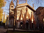
- Convent of S. Francesco in Susa. The oldest Franciscan convent in Piedmont, it preserves valuable frescoes and two beautiful cloisters (which can be visited from the annexed pilgrim's house)
- Sanctuary of the Madonna del Rocciamelone (located on the summit of Mount Rocciamelone, in the municipal area of Mompantero). It is located at 3538 meters above sea level. (it is one of the highest sanctuaries in Europe). The history of the sanctuary is linked to an ex voto commissioned in the Flanders by the merchant of Asti Bonifacio Rotario and brought to the summit in 1358. Currently on the top there is a bronze statue of the Virgin Mary, donated by the Children of Italy at the invitation of Bishop Mons. Edoardo Giuseppe Rosaz (now Blessed), and brought to the summit by Alpini in 1899. The summit can be reached on foot with an excursion of mountaineering difficulty, with equipment suitable for a high mountain environment. In the terminal part there are rather dangerous passages on the cliff, not suitable for everyone.
- Church of San Giovanni Battista (in Salbertrand). Rebuilt in the 16th century and decorated with splendid frescoes
Castles and fortifications


- Fort of Exilles.
- Medieval village of Avigliana.
- Castle of San Giorio di Susa.
- Bruzolo Castle.
- Chianocco Castle (Chianocco). It can be visited in case of exhibitions of the Museum of ancient crafts,
- Fortress of Chianocco. it can be visited on a few days set by the Municipality of Chianocco
- Countess Adelaide Castle (in Susa).
- Walls and medieval village of Susa.
- Savoy Gate of Susa.
- Tower of the Saracens of Oulx.
Museums
- Nobel dynamite ecomuseum (to Avigliana).
- Museum of ancient crafts (at the Castle of Chianocco, Chianocco).
- Museum of railway transport through the Alps (to Bussoleno).
- civic Museum (at the Castle of the City of Susa). It can be visited on the occasion of temporary exhibitions
- Diocesan Museum of Sacred Art (in Susa). Center of the Diocesan Museum System of the Diocese of Susa. Rich in initiatives for the cultural enhancement of the territory, it preserves sculptural works of the Alpine area, paintings, the most ancient local Christian testimonies and a unique work of its kind, the Triptych of Rotario, which by a vote was transported in 1358 to the summit of the Mount Rocciamelone (3,538 meters), which overlooks the city of Susa.
- Ecomuseum of the Terre al Confine (to Moncenisio).
- Ecomuseo Colombano Romean (to Salbertrand).
- civic Museum (to Bardonecchia).
- Forte di Bramafam (a Bardonecchia).
Itineraries

On foot
Da sempre luogo di passaggio da e per la Francia, la Valle di Susa negli ultimi anni ha visto riscoprire il tratto della Via Francigena che la percorreva, per iniziativa della Chiesa Cattolica Italiana con il pellegrinaggio Ad limina Petri e degli enti locali con progetti e iniziative appositi. Si tratta delle due varianti valsusine che si riunivano a Susa per poi proseguire verso Torino: una che attraverso il Colle del Monginevro la congiungeva al Cammino di Santiago di Compostela, l'altra che tramite il Colle del Moncenisio collegava Italia con Francia del Nord, Belgio, Olanda e Inghilterra. Gli enti locali hanno attrezzato le vie per il percorso dei pellegrini moderni che vogliono camminare lungo la via Francigena. Per la Via Francigena, si può consultare il sito Turismotorino.
By bike
Le vie secondarie della Bassa Valle Susa costituiscono la Ciclostrada della Valle di Susa, che da Avigliana giunge a Susa e poi a Moncenisio.Molto apprezzate dagli appassionati di bicicletta sono la salita Novalesa-Moncenisio e la salita Meana-Colle delle Finestre, entrambe percorse in passato dal Giro d'Italia.Una classica per gli appassionati di ciclismo è il "giro del Sestriere", un itinerario di lunga percorrenza che da Torino prevede la salita al Colle del Sestriere dalla Valle Chisone e la successiva discesa lungo la Valle di Susa, o viceversa.Il territorio è inoltre inserito da anni nell'itinerario dell'Iron Bike e ogni anno si tengono manifestazioni come la Via dei Saraceni, da Sauze d'Oulx.
In moto

La Valle di Susa è uno degli itinerari prediletti per i motociclisti nel Nord-Ovest italiano. Infatti, attraverso la Valle di Susa essi possono valicare il Colle del Moncenisio e una volta in Francia, percorrere i Colli del Telegraphe, del Galibier, del Lautaret e del Monginevro, rientrando in Valle di Susa. Da Cesana, la scelta è tra discendere la Valle o valicare il Colle del Sestriere per percorrere la Val Chisone. Identico itinerario si può percorrere in auto.
By car

In Bassa Valle Susa, un itinerario molto frequentato in estate è quello del Moncenisio, alcuni chilometri oltreconfine lungo la SS25. In molti salgono al Colle per godere il panorama alpino che si specchia nel grande lago artificiale del Moncenisio e per estendere la visita alla vicina valle della Maurienne, scendendo a Lanslebourg o spongendosi sino a Bonnevalle, ai piedi del Col de l'Iseran, dal quale si può scendere a Bourg St. Maurice e quindi tramite il Piccolo S. Bernardo in Valle d'Aosta, per fare ritorno a Torino.Un itinerario più breve in Alta Valle di Susa è lo scollinamento del Colle della Scala da Bardonecchia, con passaggio da Nevache, discesa della Valle de la Claree, tappa a Briancon e rientro in Valle dal Colle del Monginevro.
What to do


- Sci. L'Alta Valle Susa presenta numerose stazioni sciistiche (Sestriere, Cesana San Sicario, Cesana Monti della Luna, Claviere, Sauze d'Oulx) raggruppate nel comprensorio detto "Via Lattea" che dà la possibilità di estensione anche alle piste della stazione francese di Monginevro. Sempre in Alta Valle, numerosi impianti sono presenti a Bardonecchia (stazioni di Melezet, Campo Smith e Jafferau), raggiungibili anche col treno SFM3. Più vicino alla Bassa Valle, impianti sciistici anche a Chiomonte (Pian del Frais), collegati alla linea SFM3 dalla stazione FS di Chiomonte.
- Visite Culturali. La lettura del passato permette di identificare quattro tessere del suo mosaico culturale, vero deposito di testimonianze storiche e artistiche: le fortificazioni, l’arte sacra, la cultura materiale e l’archeologia si intersecano con molteplici percorsi culturali, naturalistici e sportivi nella nostra Valle. Sono le aree archeologiche di Susa, dal Museo Diocesano di arte sacra e il Sistema Museale Diocesano, dal Dinamitificio Nobel di Avigliana, dalle abbazie di Novalesa o della Sacra di San Michele, dal forte di Exilles o dal Bramafam.
- Escursioni in montagna. Tutta la Valle Susa è percorsa da sentieri in quota o di risalita dal fondovalle. Sia in bassa, sia in alta Valle, esistono itinerari segnalati che possono essere percorsi per trekking a piedi. In Alta Valle Susa, pregevoli sono le mete della Valle Argentera, dei Monti della Luna, della Valle Stretta, dello Jafferau e del Vallone di Rochemolles di Bardonecchia,di Sauze d'Oulx e del Gran Bosco di Salbertrand. A monte di Susa, è possibile compiere il Tour del Giusalet con partenza dal Rifugio Mariannina Levi di Grange della Valle (Exilles), dal Rifugio Avanzà di Venaus o dal Rifugio Petit Mont-Cenis al Colle del Moncenisio. Una delle classiche del trekking alpinistico della Valle è la salita al santuario in cima al monte più alto, il Rocciamelone, che tuttavia presenta rischi anche elevati in caso di disattenzione o maltempo, a causa dei profondi precipizi (letali in caso di caduta) su cui si inerpica il sentiero a monte del Rifugio.
In bassa Valle Susa, molto apprezzati sono gli itinerari del Parco Orsiera (Giro dell'Orsiera, oppure le mete di Rifugio Toesca, Rifugio Amprimo, Rifugio Geat, Certosa di Montebenedetto), le due salite alla Sacra di S. Michele da Chiusa di S. Michele o da S. Ambrogio, la salita alla Rocca Sella di Caprie.
- Sport estremi. La Valle di Susa ospita anche praticanti di sport estremi con un alto grado di pericolo individuale, come la risalita delle cascate di ghiaccio ad esempio nella zona di Novalesa. In estate vi viene praticato il torrentismo.
.jpg/220px-Rio_Claretto_(Val_di_Susa_-_Italia).jpg)
At the table
La Valle di Susa, per il particolare microclima che la contraddistingue dalle altre vallate alpine per la presenza di importanti vie di comunicazione verso la Francia e verso la pianura che hanno reso possibile sin dall'antichità il continuo scambio di prodotti e di saperi, offre oggi molte varietà di prodotti della terra e numerose produzioni tipiche declinati poi con una sapiente e ricca tradizione culinaria.
I Formaggi
La produzione dei formaggi con metodi naturali e genuini, dove si ritrova la tradizione dell'alpeggio in quota, garantisce di ottenere latte e formaggi dal sapore particolare ed dall'intensità di profumi dovuti alla presenza di erbe aromatiche nei pascoli di altura. Il colore e gli aromi dipendono anche dai metodi di produzione e trasformazione, oltreché i diversi tempi di stagionatura: la toma del Moncenisio, nota già in epoca medioevale, il formaggio a crosta rossa per il trattamento di acqua e sale della superficie, le grandi forme di murianeng, la toma del lait brusc dalla pasta friabile, il burro profumato e il morbido seirass sono tra le produzioni più note diffuse.Questi formaggi non vanno conservati in frigorifero, ma in un ambiente fresco e ben aerato. Il formaggio è un prodotto vivo e al suo interno i processi fermentativi continuano dando luogo a sostanze che migliorano la qualità del prodotto.
Pane e Biscotti
Profumo di burro, limoni, cacao, latte fresco noce moscata, nocciole, uova e zucchero caramellato inondano ancora le panetterie e le pasticcerie della Valle di Susa ma anche le case dei valsusini che per le feste patronali ancora mantengono la tradizione di sfornare i dolci della tradizione. Forse legati ad una tradizione conventuale, ma certamente imparentati tra di loro con varianti locali o addirittura segrete ricette di famiglia i tipici Canestrelli di Vaie e i canestrelli di San Giorio vengono cotti a fuoco vivo sui “ferri” piastre dai decori particolari diventando gustosi biscotti friabili, e ancora dalla cottura più lenta i gofri dell'alta valle sono fragranti e golose cialde nelle varianti dolci e salate.Nelle piccole frazioni di montagna dove era più difficile raggiungere il forno del pane, i gofri venivano preparati una volta la settimana per essere alternati al pane che in Valle di Susa risente molto della tradizione piemontese con la forma delle biove e delle miche affiancando la tipica chianocchina dalla crosta croccante e dalla mollica morbida che conserva la sua freschezza per diversi giorni. Dalle eroiche coltivazioni di montagna la segale per secoli è stata la farina più utilizzata per il pane, che una volta indurito era impiegato in cucina per le zuppe grasse a base di formaggio e brodo o per addensare le salse. L'arrivo del mais tra le coltivazioni del fondovalle ha reso celebri le fragranti paste di meliga di Sant'Ambrogio e riscoperto il pan'ed meliga di Chiusa, piccoli panini salati morbidi e saporiti.Inconfondibile e la celebre Focaccia di Susa, pane dolce zuccherato di antica origine “che conquistò i Romani”.
Miele
In Valle di Susa le condizioni climatiche influiscono positivamente sulla varietà di flora mellifera ed la produzione del miele valsusino ha la caratteristica di essere veramente naturale perché non sono previsti altri trattamenti, se non le semplici filtrazione e decantazione.I piccoli produttori della Valle di Susa puntano soprattutto sulla qualità del miele prodotto in zone montane: il miele di millefiori, il più diffuso ed il più apprezzato dai consumatori dai profumi variabili in base alla flora visitata dalle api. Il miele di castagno è più indicato per chi non ama i sapori molto dolci per la presenza di tannini che lo rendono più amaro rispetto ad altri mieli, ma è certamente il castiglio (castagno e tiglio) il più diffuso in Valle di Susa.Molto raro, e dal sapore delicato e particolare, il miele di rododendro si produce in un periodo limitato di tempo spostando le api in montagna a quote tra i 1500 ed i 2000 m. nel periodo di fioritura della pianta, tra fine giugno e inizio di luglio. Per le grandi dimensioni dei cristalli, il miele di rododendro non si presenta mai liquido ma sempre cristallizzato.
Castagne
I castagneti in Valle di Susa affondano le radici in tempi antichi e il primo documento ufficiale a menzionare tale coltura risale al 1200 in riferimento alle dipendenze della certosa di Montebendetto.La castanicoltura è sempre stata molto importante per la comunità valsusina, sia come fonte di reddito, sia come elemento di integrazione alimentare prima della diffusione della patata o della farina di mais. Oggi la castanicoltura è diffusa a una quota che oscilla tra i 300 e gli 800-1000 metri sui versanti più soleggiati e presente tre ecotipi autoctoni per la produzione di castagne da frutto: Bruzolo, San Giorio e tardiva di Meana.In particolare le prime due varietà sono importanti per la produzione di marroni: i frutti sono infatti costituiti da castagne di pezzatura più grossa, tendenzialmente rotondeggianti e con poca pelosità, adatte ad essere trasformate in Marrons Glacés.Forte di questa tradizione la produzione è diffusa in tutto il territorio valsusino e la qualità è molto elevata: il Marrone Valsusa può infatti fregiarsi dal 2007 della etichetta I.G.P.
Patate
Arrivata in Italia dopo la scoperta dell'America, la patata è entrata a far parte della base alimentare delle popolazioni alpine e valsusine assicurandone il mantenimento e diventando oggi una produzione tradizionale.La Valle di Susa era famosa ben oltre i suoi confini per la squisitezza delle sue patate, fama che le compete ancora oggi. Infatti la pianta in montagna accumula nei tuberi degli zuccheri particolari che la rendono molto più saporita rispetto a quelle di pianura.La pasta varia dal giallo al bianco a seconda delle varietà coltivate, è di buona consistenza e resiste alla cottura senza sfaldarsi.
A questi pregi però, corrisponde una bassa produzione, di quattro volte inferiore rispetto a quella delle patate di pianura. In più la difficoltà di meccanizzazione obbliga gli agricoltori a seminare e raccogliere a mano, senza l'ausilio delle macchine. Le patate trovano produzione in tutta la valle, ma particolarmente pregiate risultano essere quelle di San Colombano di Exilles, Sauze d'Oulx, di Mocchie con le rarissime patate viola, di Cesana Torinese, e della Ramat di Chiomonte.
Mele e piccoli frutti
La coltivazione del melo ha radici antiche in Valle di Susa e in particolare nei paesi del fondovalle dove per il particolare microclima nella fascia tra i 400 e i 900 metri, sono state selezionate delle particolari varietà autoctone come la Susina, la Giachetta e la Carpendù, già citata in antichi manuali di pasticceria sabauda.Le coltivazioni di mele, ma anche pere, caratterizzano in maniera peculiare il paesaggio agricolo di Gravere, Mattie e Caprie, dove nel mese di novembre la sagra "La mela e Dintorni" promuove le produzioni locali.
Oggi le mele della Valle di Susa sono vendute direttamente in azienda ad amatori dei prodotti di nicchia e turisti, ma si trovano anche ai mercati settimanali o nelle fiere enogastronomiche.
Drinks
Vino liquori e distillati
La rigorosa cura posta nella produzione, nella conservazione e nell'estrazione delle essenze, l'amore del proprio lavoro insieme a quello per la propria terra, le tradizioni coniugate con la tecnologia ed il progresso, fanno sì che questi liquori abbiano il sapore deciso e pulito della montagna e il profumo delle erbe alpine. Tra le bevande più rinomate troviamo il rarissimo vino del ghiaccio o l'Eigovitto, l'acquavite di altissima qualità, e tutti prodotti con i vitigni autoctoni unici al mondo, l'Avanà.
Tourist infrastructure
Sia l'Alta che la Bassa Valle di Susa presentano un cospicuo numero di Hotel, strutture alberghiere e Bed and Breakfast che offrono ottimi servizi tutto l'anno.
Safety
How to keep in touch
Rimanere in contatto sugli eventi e le proposte della valle è molto semplice, attraverso i siti e le newsletter.
Around
Other projects
 Wikipedia contains an entry concerning Val di Susa
 Commons contains images or other files on Val di Susa
 Wikiquote contains quotes from or on Val di Susa
 Wikinews contains current news on Val di Susa