| Gazzaniga | ||
 | ||
| State | Italy | |
|---|---|---|
| Region | Lombardy | |
| Altitude | 386 m a.s.l. | |
| Surface | 14.41 km² | |
| Inhabitants | 5.161 (2010 census) | |
| Name inhabitants | Gazzanighesi | |
| Prefix tel | 39 035 | |
| POSTAL CODE | 24025 | |
| Time zone | UTC 1 | |
| Patron | Saint Hippolytus | |
Position
| ||
| Tourism site | ||
| Institutional website | ||

Gazzaniga is a city of Lombardy, inAlto Bergamasco.
To know
Geographical notes
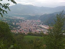
The municipal territory of Gazzaniga is entirely located on the orographic right of the Seriana valley, at a height of about 380 m s.l.m. Most of the population resides in the residential areas located in the valley floor along the river Serio. Coming from Bergamo, the fraction of Rova is first encountered, territorially delimited by the Rovaro and Roncliscione streams, but now merged into a single urban agglomeration with the capital Gazzaniga, located a little further north, which in turn is united with neighbors Fiorano al Serio, Vertova is Colzate.
Inside, the small Plaz valley develops, which, crossed by the Roncliscione stream, rises from the inhabited center of the capital, touches the hamlets of Masserini and Orezzo, and ends in Ganda, a hamlet of Aviatico. Squeezed between the Cedrina and Ganda mountains and closed at the head of the Mount Poieto, is parallel to another valley, more hidden and uncontaminated, called Val del Gru, which develops in the pelvis of the Val Vertova of which it is tributary from the right near the border with Vertova.
When to go
The average temperature of the coldest month, January, is 1.0 ° C; that of the hottest month, July, is 21.8 ° C.
Rainfall is concentrated in October, while the driest month is February.
Background
The first remains attesting to the human presence on the territory of Gazans can be traced back to the Bronze Age. The first settlements, on the other hand, date back to the 6th century BC. when populations of Ligurian origin settled in the area, dedicated to sheep farming, including the Orobi. To them were added and integrated, starting from the fifth century BC, the populations of Celtic stock, including the Cenomani Gauls.
However, the first real urbanization work was the work of the Romans, who conquered the area and subjected it to centuriation, or a subdivision of the land to several owners, starting from the 1st century AD. In any case, during this period, the center was very small with the inhabitants who relied on agriculture, mainly in the plain of the valley floor, and pastoralism in the hilly area.
The Roman domination overlapped and replaced that of the Lombards, who founded their nucleus (or Fara) in what is now via Briolini, creating a courtyard around which the inhabited center developed in the following centuries. With the arrival of the Franks, which took place towards the end of the 8th century, the territory was subjected to the feudal system, with the town which, like most of the valley, was given a fief to the Bishop of Bergamo.
The next step was to definitively emancipate himself from the feudal yoke, drawing up the first statutes in 1240 that gave way to the municipal experience.
However, friction soon began to occur between the inhabitants, divided between Guelphs and Ghibellines, who reached unprecedented levels of resurgence. The municipal institution, siding with the Guelph faction, had to suffer numerous attacks perpetrated by the opposing faction, culminating in the very hard battle that occurred in the year 1397, during which much of the town was destroyed and burned by the Ghibellines. On the other hand, the following year, on 10 June, it was the Guelphs themselves who significantly damaged the Ghibelline outposts located throughout the territory, simultaneously setting fire to much of the town.
The definitive pacification came a few years later thanks to the advent of the Republic of Venice, which took place formally in 1428, which gave way to a period of tranquility in which the entire area resumed prosperity, also thanks to the decrease in taxation and to greater autonomy.
Starting from 1435, the municipal boundaries had also included the territories of Rova and Fiorano, with the latter returning autonomous as early as 1476.
A violent shock to the tranquility of the population came from the violent epidemic of plague of Manzoni's memory, which between 1629 and 1631 halved the number of inhabitants.
During the eighteenth century there was first the erection of Orezzo as an autonomous municipality (1756) then, following the treaty of Campoformio, the end of the power of the Serenissima, replaced in 1797 by the Napoleonic Cispadana Republic. The change of domination involved a revision of the borders, which saw the union of Gazzaniga with Fiorano. Union did not last long, since already in 1805 the two municipalities were again split.
After four years the territorial limits were redesigned again through an imposing work of merging the small towns with the larger ones: in this juncture Gazzaniga absorbed the nearby realities of Cene, Fiorano and Orezzo, which managed to regain their autonomy in 1816, on the occasion of the new change of government that saw the Austrian Kingdom of Lombardy-Venetia take over from the French institutions.
In 1827 the Confederation de Honio was definitively dissolved, with Gazzaniga who formally acquired all the hilly and mountainous lands covered by woods to the north of the town.
Of great importance for the local economy was the settlement of an important industrial reality linked to the weaving of silk and cotton, which had the Briolini family as its main referent, which led to a significant increase in both commercial traffic linked to the induced and of the population, which in the few decades tripled, passing from 1,500 to 4,500 units.
A further impulse came from the opening of the Seriana Valley Railway, which since 1884 allowed the connection of goods and passengers from Bergamo to Clusone.
In 1927 the Fascist regime, as part of an administrative reorganization aimed at favoring the large centers to the detriment of the smaller ones, once again united Fiorano with Gazzaniga. The union lasted until the end of the Second World War, when in December 1947 Fiorano al Serio regained its definitive autonomy.
In the second part of the twentieth century the municipality saw a tumultuous social, economic and urban development, which led to the incorporation of the various districts into a single nucleus, with a solution of housing continuity that also involved the neighboring villages of the valley floor.
How to orient yourself
Gazzaniga is bordered to the south-east by the river Serio, which divides it from the municipality of Dinners; to the south it borders, in the most upstream part, with Aviatico through the slopes of mount Ganda, while in the lower part with Albino, through the course of the Rovaro stream that flows into the small valley of the same name. To the north the territorial limit is with Fiorano al Serio, while to the north-east with Vertova, through the Vertova stream, located in the homonymous valley. Finally to the west and north-west the orographic watershed with the Val Serina, tributary of the Brembana valley, which goes from the locality Forca to mount Suchello, marks the border with the municipalities of Costa Serina is Cornalba.
How to get
By plane
The nearest airport to Gazzaniga is:
- 1 Bergamo-Orio al Serio airport (the Caravaggio), Via Aeroporto 13, Orio al Serio, ☎ 39 035 326323. From this airport there are many low cost flights operated by the Irish airline ryanair.
By car
Gazzaniga can be reached from the south from the![]() of Bergamo following the SP35 or di Serious following the SS671 towards Seriana Valley-Clusone, while it can be reached from the north by following the signs for Bergamo along the SS671.
of Bergamo following the SP35 or di Serious following the SS671 towards Seriana Valley-Clusone, while it can be reached from the north by following the signs for Bergamo along the SS671.
On the train
From 2 Albino station, Gian Battista Moroni Square. you can reach the station of Bergamo with the TEB tramway from which it can then be reached Milan, Lecco is Brescia on the train.
By bus
- 3 Gazzaniga bus station, Station square.
For information on the lines passing by Gazzaniga consult the website move in Lombardy.
How to get around
 The town of Gazzaniga passes the 4 cycle route of the Seriana Valley[link not working] which extends from Bergamo to Clusone for a total length of 47 km.
What see


- 1 Provostal church of S. Maria Assunta and S. Ippolito, piazza XXV aprile.
- 2 Geological garden of the Seriana Valley, via Salici.
- 3 Gazzaniga black marble, via Guglielmo Marconi 18. The small exhibition is outdoors in a small garden adjacent to the Town Hall and the Library, with the recovery of large semi-finished monoliths positioned in this public space.
- 4 Briolini Mausoleum, via Roma.
- 5 Maestro Luigi Pezzera Museum, via Dante Alighieri 32 (Gazzaniga Elementary Schools), ☎ 39 035 710679.
Events and parties
- 5 Patronal Feast of Sant'Ippolito, piazza XXV aprile. This takes place every year on August 13th.
What to do
Shopping
How to have fun
Shows
- 1 Continental Cinema, via Battisti 75, ☎ 39 035 711362. During the summer, the screenings are suspended.
Where to eat
Average prices
- 1 Leone wine shop, piazza XXV aprile 10, ☎ 39 035 711225, @[email protected].
 Tue-Sat 8: 00-12: 00 and 17: 30-24: 00.
 - 2 The Skyscraper Pizzeria Restaurant, via Daniele Maffeis 5, ☎ 39 035 712171, @[email protected].
- 3 La Penzana, away to the Church 4, ☎ 39 035 712021.
Where stay
Average prices
- 1 Hotel Serenella, via Cesare Battisti 129, ☎ 39 035 738475, fax: 39 035 738469, @[email protected].
Safety
 6 Fire fighters (Gazzaniga Volunteers Detachment), via Salici 38, ☎ 39 035 711222.
 7 "Briolini" Hospital, via Alessandro Manzoni 130, ☎ 39 035 3065111.
How to keep in touch
Post office
- 8 Post Office, via Guglielmo Marconi 33, ☎ 39 035 711669, fax: 39 035 720526.
For more information and the opening hours of the Gazzaniga post office, visit the website poste.it.
Keep informed
- 9 Pro Loco Gazzaniga - Orezzo, via Sottochiesa 20, @[email protected].
Around
- There are numerous opportunities for those wishing to spend some time immersed in nature, with many paths that wind along the slopes of the surrounding offshoots. Among the main ones there are those marked with CAI trail number 521 and 522 that branch off from Ganda. The first reaches the hamlet of Rova, while the second reaches and runs through the "Val di Plaz" ending in the inhabited center. There is also the 523 which branches off from Coldrè (located upstream of Orezzo in the direction of Mount Poieto), reaches the localities of Osciöl and Dossello and then descends into the valley floor between Gazzaniga and Fiorano al Serio. This is where track number 524 intersects, which originates in the locality of Osciöl and develops on the northern side of the Mount Cedrina, first crossing the characteristic and hidden Val del Gru, then intersecting the Val Gromalt and finally reaching the slopes of mount Suchello.
- Val Vertova - It is considered one of the most evocative and naturalistically relevant places in the whole Province of Bergamo.