 | |
| Limpopo Province | |
| Capital | Polokwane |
|---|---|
| Residents | 5.404.868 (2011) |
| surface | 125,754 km² |
| website | www.limpopo.gov.za/ |
| Tourist info web | Go limpopo |
| no tourist info on Wikidata: | |
| location | |
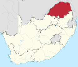 | |
Limpopo is a province in the northeast South Africa, it was named after the river of the same name that the northern border to Botswana, to Zimbabwe and to Mozambique forms. Neighboring South African provinces are North West, Gauteng and Mpumalanga.
Regions
- Mopani - The district in the east of the region is dated Olifant River flowed through.
- The Kruger National Park is mostly in the Mopani district, its southern part is part of the province Mpumalanga.
- Vhembe - Lies in the north of the province and is crossed by the ridge of the Soutpansberg.
- Waterberg - The Bushveld district in the west is crossed by the Waterberg Mountain Range,
- Capricorn - Is named after the Tropic of Capricorn, which runs through this district.
- Sekhukhune - Located in the south of the province. Copper, platinum, gold and chrome are mined in the mining region.
places

Map of Limpopo


Other goals
- 1 Kruger National Park


 in the Wikidata database")

- Valley of the Elephants
.jpg/350px-Impalas_and_Zebras_at_Duke's_Waterhole_(16589771331).jpg)
background
language
getting there
mobility
Tourist Attractions
activities
kitchen
nightlife
security
climate
literature
Web links
- http://www.limpopo.gov.za/ - Official website of Limpopo
- Go limpopo official tourism website of the province
