The extensive Lüneburg Heath Nature Reserve shows the much-visited natural and cultural landscape of the heath in Lower Saxony.
In particular for Heather blossom, which lasts from early August to late September, the park is a worthwhile destination. However, the nature reserve has long since ceased to be an insider tip - there is a lot going on in the main season, especially around Wilsede.
The "main program" (Wilsede, Wilseder Berg, Totengrund) can easily be completed in one day. One day is of course not enough to get to know the entire "Lüneburg Heath" region.
But you can also spend several days alone in the area of the nature reserve. The large protected area is also under the title Lüneburg Heath Nature Reserve known.

places
Places on the edge of the protected area:
- Bispingen with the Heidedorf Wilsede, in the southeast
- Egestorf in the Northeast
- Handeloh in the north-west
- Hanstedt in the North
- Schneverdingen in the southwest
- Soltau in the south with the amusement park "Heidepark"
- Undeloh - The small hamlet is centrally located in the north of the protected area
background
history

The 22,000 hectare "Lüneburg Heath Nature Reserve" is one of the oldest German protected areas that protect a cultural landscape.
As early as 1921, 200 square kilometers were placed under protection. Today, many people looking for relaxation visit the most famous heathland of the "Lüneburg Heath" every year. On beautiful Sundays when the heather is in bloom, up to 10,000 travelers visit the well-known hamlet of Wilsede every day. On weekdays and away from the area between Undeloh and Nieder- or Oberhaverbeck with Wilsede, Wilseder Berg and Totengrund, there are even less overcrowded areas in the protected area when the heather is in bloom.
landscape

The reserve is located in a sandy hill country with a lot of pine forest and wide heather areas. The famous Heidschnucken are used as "natural lawnmowers" to keep the heather open. The cultural landscape was created through overexploitation. As a landscape conservation measure, the top, nutrient-rich humus layer is partly removed by machine today. This creates an optimal growth space for the undemanding heather. This process is also called Plagues designated.
Incidentally, the heather blooms from the beginning of August to the end of September.
Flora and fauna
As of 2007 there are around 80 Black grouse at home in the NSG.
climate

The temperate north German climate prevails in the protected area. The precipitation falls fairly evenly over the year. On the open ridge, the "Hohen Heide" (Wilseder Berg and Wilsede area), there is usually a pleasant "breeze" that cools you down on hot summer days.
getting there
By plane
By bus and train
The core area of the protected area has no rail connection.
The free leisure bus "Heide-Shuttle" binds in the season among other things. the train stations Schneverdingen, Wintermoor, Bispingen and Toestedt (route Bremen - Hamburg with metro connection) to the central parking area. There are a total of four ring lines on the Heide Shuttle. The buses run daily between July 15th and October 15th. For information with an overview map and timetables, see page of the Side of the natural park.
Rail connections exist nationwide Hanover, Buchholz and Uelzen to Soltau.
In the street
The nature reserve can be reached via the A7 Hanover - Hamburg motorway.
Directions from the A7 motorway: If you arrive via the A 7, it is best to leave the motorway at the "Bispingen" junction (No. 43). After 7 km you will reach the hamlet of Oberhaverbeck behind Behringen. There is a large car park to the left of the street. 2 km further there is another large parking lot in the hamlet of Niederhaverbeck on the right of the country road (for location and further information, see section "Park".
By bicycle
The Leine-Heide-Radweg long-distance cycle path connects the protected area to the major cities of Hamburg and Hanover.
On foot
A special way of approaching the Heidepark is by pilgrimage. The pilgrimage route "Jakobus-Weg Lüneburg Heath" from Hittfeld to Mariensee leads through the park (Side of the pilgrimage route)
fees
The cultural landscape of the area is freely accessible.
mobility

Park
If you want to reach the car-free Heidedorf Wilsede, park in one of the following places:
- 1 Oberhaverbeck car park. Parking for cars, coaches and RV parking (fresh water, electricity, waste water disposal). On the eastern edge there is a public toilet (for a fee) and a snack bar. Carriages start at the parking lot for trips to the Heidedorf Wilsede, 4 km away. Those who like to hike can also start on foot from Oberhaverbeck. A full-day circular hike from Oberhaverbeck over the Wilseder Berg, the Heidedorf Wilsede and the Toten or Steingrund is about 11 to 13 km long, depending on the route chosen.Price: Car: € 1.50 for 4 hours, day ticket € 4, motorhome parking space: € 9 per night including 2 people.
- 2 Niederhaverbeck car park. Otherwise no further infrastructure is available for mobile homes. Snack bar and carriage rides on site. Full-day circular hike Wilseder Berg, Wilsede and Totengrund, depending on the route, 12 to 14 km. Alternatively, carriage rides from the parking lot in the direction of Wilsede.Price: Car: € 1.50 for 4 hours, day ticket € 4, overnight rate for mobile homes: € 6.
- 3 Parking lot Undeloh. Otherwise no further infrastructure is available for mobile homes. The Heide Adventure Center is directly opposite the parking lot. Full-day circular hike to Wilsede: It is best to first walk along the beautiful Herrman-Röhrig-Weg to Wilseder Berg and then on to nearby Wilsede (round about 10 km, with a detour to Totengrund about 14 km). Alternatively, carriage rides from the parking lot in the direction of Wilsede.Price: Car: € 1.50 for 4 hours, day ticket € 4, overnight rate for mobile homes: € 6.
- 4 Döhle car park. Parking in the local area. It is about 5 km to Wilsede. During the high season of the heather bloom, carriage rides are offered from Döhle.Price: unclear.
bicycle
The bicycle is a popular means of transport in the protected area. There is a dense, signposted network of cycle routes. The network of paths in the nature reserve is, however, partly accessible only at reduced speed and with a somewhat practiced driving technique. Sand pavement, carriage tracks and coarse cobblestones create problems for getting around by bike, depending on the route. After rainfall there are sometimes larger puddles.
On foot
The protected area can easily be explored on foot. It is best to choose the smaller paths here, some of which are not used by horse-drawn carriages or horses. Here you usually have a solid sand cover on which you can walk satisfactorily. In addition to the coarsely paved driveways or rutted sand paths, there are also some narrow additional paths with fine gravel or solid sand cover for pedestrians or cyclists.
Information centers and museums
- Museum "Dat ole Huus" in Wilsede (information in corresponding subsection here)
- 1 Heide adventure center in Undeloh. The information center shows an interactive "hands-on exhibition" on the subject of "heather". There is also a small museum shop with regional products from around the heath. The center also has a cafe.Open: free of charge.Price: probably changing opening times, can be found on the centre's website.
- 2 Haverbeck nature information center. You can see the exhibition "Bienenwelten" about the life of honey bees. Products related to bees can be purchased in a small museum shop.Open: in the summer season until around mid-October, exact times not known.Price: not known.
- 3 Ehrhorn Forest Experience Center. The Lower Saxony State Forests are the sponsors. In the freely accessible area there is a 3.5 km long forest adventure trail (among other things, if the hint "Trojaburg" is on Openstreetmap, there is also a parking lot on the country road).Open: unknown.Price: unknown.
Tourist Attractions
Wilsede

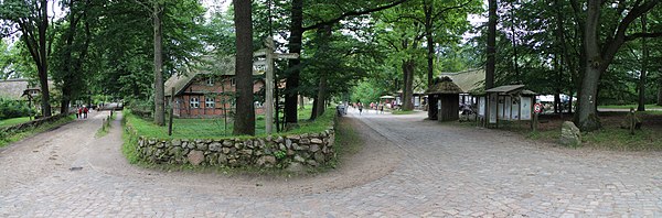
The small heath village of Wilsede with 40 inhabitants is the tourist center of the park. It can only be reached by horse-drawn carriage, bicycle and on foot. The next car parking spaces with a horse-drawn carriage connection are in Nieder- and Oberhaverbeck, as well as in Wilsede (for information see section mobility).
The cozy heather houses from the 18th century with their thatched roofs are worth seeing. The village can also be seen as a kind of "inhabited, rural museum village" representative of the history of the Lüneburg Heath region. The entire village area can often still be found in the appearance of more than 100 years ago. There are no asphalt roads here, only historic cobblestone roads as well as sand and gravel paths.
- 4 Museum "Dat ole Huus".


 Heidehaus from the 18th century; Exhibition on heather farming. The building was erected in 1724 and is a typical residential building in the north heath. The teacher Bernhard Dageförde had the building dismantled in 1907 at its previous location in Hanstedt. On his initiative, the building was then rebuilt at its current location in Wilsede as a museum building. For more information about the building, see also corresponding Wikipedia article.Open: between May and the beginning of October daily from 10 a.m. to 4 p.m.Price: 3 euros, children up to 16 years are free.

- Museum shop Wilsede: Here you can buy regional products and gifts. The shop is located opposite the museum in the "Milchhalle".
- gastronomy
- public toilets at the milk hall (according to Openstreetmap with fee).
Wilseder Berg
5 Wilseder Berg. ![]()
![]()
![]() At 169.2 m, the hill is the highest point on the Lüneburg Heath. The much-visited elevation is about 1.5 km west of Wilsede. pastor Wilhelm Bode acquired the heath area on Wilseder Berg in 1910 to protect it from planned reforestation. So you can still admire the beautiful view today. From the summit you have a beautiful south-west to north-west view over the vast forests and heathland. The panorama from Wilseder Berg is often used nationally and internationally as a symbol of the romanticism of the entire Lüneburg Heath region.Price: freely accessible.
At 169.2 m, the hill is the highest point on the Lüneburg Heath. The much-visited elevation is about 1.5 km west of Wilsede. pastor Wilhelm Bode acquired the heath area on Wilseder Berg in 1910 to protect it from planned reforestation. So you can still admire the beautiful view today. From the summit you have a beautiful south-west to north-west view over the vast forests and heathland. The panorama from Wilseder Berg is often used nationally and internationally as a symbol of the romanticism of the entire Lüneburg Heath region.Price: freely accessible.

Dead ground and stone ground

6 Dead ground. ![]()
![]()
![]() The Totengrund is about 1.5 km southeast of Wilsede. The romantic dry valley is overgrown with heather and juniper. Incidentally, the depression was created by meltwater in the Saale Ice Age. pastor Wilhelm Bode acquired the Totengrund in 1906 with the help of donations and thus laid the foundation stone for today's large protected area. Around the Totengrund you will find various viewpoints with a view of the dry valley. The main viewing point with the most famous view of the valley basin can be found at the Andreas Thomsendenkmal (at the location of the number). The name "Totengrund" goes back to the poor soil in the dry valley. For the farmers, this land was largely worthless and therefore "dead".Price: freely accessible.
The Totengrund is about 1.5 km southeast of Wilsede. The romantic dry valley is overgrown with heather and juniper. Incidentally, the depression was created by meltwater in the Saale Ice Age. pastor Wilhelm Bode acquired the Totengrund in 1906 with the help of donations and thus laid the foundation stone for today's large protected area. Around the Totengrund you will find various viewpoints with a view of the dry valley. The main viewing point with the most famous view of the valley basin can be found at the Andreas Thomsendenkmal (at the location of the number). The name "Totengrund" goes back to the poor soil in the dry valley. For the farmers, this land was largely worthless and therefore "dead".Price: freely accessible.


7 Stone ground. The delightful stone ground can be found directly west of the well-known Totengrund. Anyone who walks from Wilsede to Totengrund can stop by here.

"Töps" heathland
- 8 "Töps" heathland. The "picture book landscape" surrounded by forest is about 3 km west of Hanstedt or 6 km north of Undeloh. On a clear day, the view extends from here to Hamburg. There are two historical sheep stables with heather sheep in the area. Some beehives can also be found in the heather area.
Getting there:
- 5 Hikers' car park near the "Töps" heathland. Accessible from the district road K 55 Dierkshausen - Hanstedt.
Refreshment possibility:
- 1 Café Augustenhöh. also Pension (Bed & Breakfast).
Wesel Heath
- 9 Wesel Heath. The Weseler Heide is a bit away from the main streams of tourists. The elongated heather area is named after the heather hamlet of the same name, "Wesel", which belongs to the municipality of Undeloh. The pastor ponds can be found near Wesel on the heath area. A 6.2 km long nature trail leads through the area (see route with map here on the Undeloh website).Price: freely accessible.
Getting there:
- 6 Hikers' car park on the K 73 north of Wesel. Price: unclear.
- 7 Hikers' car park on the K 27 between Wesel and Undeloh. Price: unclear.
Pietzmoor
_IMG_1559.jpg/250px-Am_Rundwanderweg_Pietzmoor_(Schneverdingen)_IMG_1559.jpg)
- 10 Pietzmoor. The Pietzmoor can be found southeast of Schneverdingen. A circular hiking trail by footbridge opens up the area. From parking lot I on Heberer Strasse, the route is 4 to 5 km long.
_IMG_1559.jpg/350px-Am_Rundwanderweg_Pietzmoor_(Schneverdingen)_IMG_1559.jpg)
- 8 Directions to Pietzmoor: Parking lot I / "Feriendorf" bus stop. The "Feriendorf" bus stop is also located at the parking lot on Heberer Strasse. The Pietzmoor itself is located south of the holiday village.
activities
hike
- Walk from Wilsede to Wilseder Berg (approx. 1.5 km easy; slightly uphill with 30-40 meters of altitude)
- Small circular hike from Wilsede to Totengrund and Steingrund (almost 4 km long circuit on slightly undulating, mostly smaller paths; beautiful views over the heathland in the Totengrund and Steingrund)
- Circular hikes starting from Tütsberg at 53 ° 6 ′ 50 ″ N.9 ° 54 '47 "E. Easy paths with a view over the heathland to the Wilseder Berg. Tanzeichen (53 ° 6 '49 "N.9 ° 55 ′ 0 ″ E) on the site of the Landscape care center Tütsberg. Gastronomy.
- 1 Naturist Trail Undeloh. For Nudists there is a b-shaped nudist trail, it has a length of 7 to almost 10 km. It takes about 1 to 2 hours to walk. The route can also be hiked from the surrounding places. The beginning and end of the circular route is the small parking lot between Wesel and Wehlen. The path is marked with a large, yellow N throughout. It mainly leads over hiking and forest trails through wooded area. The naturist path is after Harzer Naturistenstieg the second institution of its kind in the Germany, but first and only in the old federal states. Due to the quiet and solitude of the Lüneburg Heath, it is no coincidence that he is in the vicinity of the Lichtheideheim Glüsingen[1] and former plants like that Sunny land in Egestorf[2] or that Light school home of the educator Dr. Martin Fränzel in Glüsingen (Betzendorf).[3] It is advisable to bring light clothing with you if you visit places outside the hiking trail. The location determination by means of a GPSSystem can be just as helpful as appropriate food, sun protection creams and repellants.
To go biking
The nature reserve, like the entire Lüneburg Heath, is suitable for cycling, as there are well-signposted and car-free routes. However, a loss of comfort in the protected area (carriage tracks, sandy paths and sometimes cobblestone streets, e.g. on the way to Wilsede) is to be expected. It is therefore advisable to use a bike with slightly wider tires. Anyone who owns a full or partial suspension bike should use it. Problems are to be expected especially with longer periods of rain.
Horse-drawn carriage rides
Provider of carriage rides in the area of the nature reserve. The list does not claim to be complete.
From Oberhaverbeck:
From Niederhaverbeck:
From Behringen:
From Döhle:
From Undeloh:
- Carriage rides with the Undeloher Hof - The provider has two handicapped-accessible carriages (one carriage even with a lifting platform for wheelchairs).
- Carriage rides with the Hotel Heiderose
- Carriage rides with the Ferienhof Heins
- Carriage rides with Hof Schröder
- Carriage rides at the Garbershof
shop
kitchen
Regional specialties are products from the Heidschnucke such as Heidschnuck ham, roast or saddle.
accommodation
Hotels and hostels
Wilsede
- 1 Gasthaus zum Heidemuseum. Tel.: 49 (0)4175 217. Quiet at night is guaranteed in "Heidedorf Wilsede".
- 2 Hotel Wilseder Hof. Tel.: 49 (0)4175 311.
Niederhaverbeck
- 3 Gasthof Menke. (also excursion gastronomy).
- 4 Haverbeckhof country house. (also excursion gastronomy).
Oberhaverbeck
Undeloh and Wesel
Accommodation can be found in the local article Undeloh (Accommodation directory of the Undeloh tourist office).
In isolation
- 6 Hotel Hof Tutsberg. The hotel with gastronomy and holiday apartments can be found in the southern area of the protected area. The facility is part of the landscape care center of the Naturschutzpark e. V. affiliated. It is about 8 km to Wilsede via Oberhaverbeck by bike or on foot.
- 7 Hotel Sudermühlen. The mill with hotel and catering can be found in the valley basin of the "Schmale Aue" on the northeastern edge of the protected area (approach by car via Sahrendorf or Egesdorf). From here you walk on the Pastor-Bode-Weg for about 6 km to Wilsede.
camping
As of January 2019, there is no campground in the protected area. Bivouacking in open space is, as is the case in Germany alone, not permitted here either.
Parking spaces for mobile homes can be found in the parking lots in Ober- and Niederhaverbeck and Undeloh (for the location of these parking spaces, see section "Park").
Probably the closest campsites to the reserve are:
- 8 Camping park Lüneburg Heath. Tel.: 49 (0)5199 275. Location near Heber (district of Schneverdingen).
- 9 Campsite rainbow. Tel.: 49 4175 661. Location near Egesdorf.
security

Hikes and bike rides at Do not tackle the threat of thunderstorms.
Attention: Simple, wooden shelters Without an iron air-termination rod on the roof, lightning rods and ring anchors in the foundation, they do not provide adequate protection against storms. On the contrary: huts standing in the open landscape can develop into a deadly trap during a thunderstorm. Unfortunately, tragic accidents in this regard have already occurred in other regions.[4][5][6]
During a bike tour through the protected area in September 2015, a lack of lightning protection systems was noticed at the relatively free-standing shelters.
Safety instructions for travelers who, in the event of a surprising storm with severe thunderstorms, have to hide in such an exposed, unsafe refuge without lightning protection:
- Yourself never lean your back against the wooden outer wall or support beam of the hut or set (especially not with wet clothing). Wood has a significantly higher specific resistance than the human body. If the transition contact is low, there is almost inevitably a larger voltage drop parallel to the wooden guardian wall with a dangerous current flow through the body to earth (e.g. due to wet or sweaty clothing in the shoulder area when leaning against the wooden wall).
- The "safest" thing is to crouch down in the middle of the hut away from the walls or wooden benches with your legs drawn up on the floor. If you have a metal base with you (e.g. an aluminum-coated seat cushion), it is best to clamp the cushion under both feet. This largely eliminates the dangerous step voltage. Due to the large air gap between the body and the wooden parts of the hut that are to be carried, one is already a lot safer. Complete, effective protection naturally only exists in shelters with standardized lightning protection.
- But you don't have to go to every refuge without a lightning rod during a thunderstorm to fall into panic and then always "curl up" on the floor as small as possible. Huts in valleys and in the high forest are relatively safe despite thunderstorms. A direct lightning strike cannot of course be ruled out here either, but it is rather unlikely as there are various higher targets in the vicinity of the hut. But even here there is only real security with a lightning rod.
trips
- 11 Lüneburg Heath Wildlife Park near Hanstedt-Nindorf with birds of prey flight demonstrations. In addition to a wolf pack, a total of over 100 animal species can be viewed.
literature
Cycling maps
The following cycle touring maps show the nature reserve and cover the region around it well:
- ADFC regional map "Lüneburg Heath" Scale 1: 75000, ISBN 978-3-87073-392-6 , 2nd edition 2009, 6.80 € - see sheet cut Bielefelder Verlag
- Bikeline cycle map Lüneburg Heath Scale 1: 75000, ISBN 3-85000-155-5 , 1st edition 2006, € 5.90 - see sheet cut Esterbauer publishing house
Web links
Local:
- Association for Nature Conservation V. - Sponsoring association of the protected area (responsible, inter alia, for landscape maintenance and the information centers).
Regional:
- Lüneburg Heath Nature Park - Official site of the nature park, which in addition to the area of the nature reserve also includes other areas of the surrounding communities.
- Lüneburg Heath Tourist Association - official page
- Lüneburg Heath Tourism - official site
- ↑Lichtheideheim. Retrieved May 12, 2017.
- ↑Sonnenland Egestorf. Retrieved May 12, 2017.
- ↑Lichtschulheim Lüneburg Land (LLL). Retrieved May 12, 2017, PDF.
- ↑HNA of June 26, 2012: "Waldeck tragedy: the shock is still deep" - accessed on February 7, 2013
- ↑HNA from July 1, 2012: "Lack of lightning protection on golf courses:" Problem has been known for a long time " - accessed on February 7, 2013
- ↑HNA of July 1, 2012: "Mourning and sympathy after the thunderstorm accident in Waldeck" - accessed on February 7, 2013