 | ||
| Uelzen | ||
| federal state | Lower Saxony | |
|---|---|---|
| Residents | 33.614 (2019) | |
| height | 43 m | |
| Tourist info | 49 581 8006172 http://www.uelzen-tourismus.de | |
| no tourist info on Wikidata: | ||
| location | ||
| ||

Uelzen is a city in Lower Saxony and lies in the Lueneburg Heath.
background
Neighboring municipalities:Emmendorf, Bad Bevensen, vest, Oetzen, Rätzlingen, Suhlendorf, Wieren, Wrestedt, Stadensen, Suderburg, Gerdau, Schwienau, Ebstorf, Barum
getting there
By plane
The nearest airports are the Hamburg Airport, the Hanover Airport and the Bremen Airport.
By train


The north-south connections from Hanover to Hamburg and the east-west connection of Magdeburg to Soltau. As a traditionally important transfer station, the train station in Uelzen serves as a station for InterCity / EuroCity. ICE's only stop here in the morning and in the evening.
Through the depot and the headquarters of the railway company metronome the local trains run on the Uelzen-Unterlüß-Eschede-Celle-Großburgwedel-Isernhagen-Langenhagen-Hanover and Uelzen-Bad Bevensen-Bienbüttel-Luneburg-Winsen (Luhe)- Hamburg (Harburg) -Hamburg Central station with double-decker car of the metronome. Smoking and alcohol are prohibited on the trains.
The east-west direction is served by Deutsche Bahn. The Uelzen-Soltau-Achim-Bremen Central Station. The Uelzen-Salzwedel-Stendal-Berlin/-Magdeburg and to the southwest the Uelzen-Wittingen-Gifhorn-My-Braunschweig. These routes are served by the regional express. An IRE that runs several times a day between Berlin and Hamburg also stops in Uelzen.
By bus
The central bus station Uelzen (ZOB) is also located directly at the train station. From here, the regional bus Braunschweig (RBB) serves all important places in the Uelzen area. In the city itself, buses run by Stadtwerke Uelzen. You can buy tickets that are valid for both bus routes.
In the street
Uelzen is located on the B4, which is meanwhile led around Uelzen by means of a bypass. The B4 leads to the north Luneburg, to the south it goes to Braunschweig. In east-west direction Uelzen is on the B71 from Soltau to Magdeburg. Another important connection is the B191, which merges from Uelzen with the B4 to the south, but then to Celle branches off. The B191 leads to the north-east Dannenberg. The B493 leads to the east Wittenberg.
mobility

The city center of Uelzen can easily be explored on foot.
Tourist Attractions
Churches
- 1 St. Mary.


 in the Wikidata database") St. Mary's Church was built around 1270. In the centuries that followed, the brick hall was rebuilt several times. The church contains, inter alia. the "Golden Ship". This is considered the landmark of Uelzen. The church windows from 1900 are also worth seeing.
St. Mary's Church was built around 1270. In the centuries that followed, the brick hall was rebuilt several times. The church contains, inter alia. the "Golden Ship". This is considered the landmark of Uelzen. The church windows from 1900 are also worth seeing. - 2 Holy Spirit Chapel

Castles, chateaux and palaces
Buildings

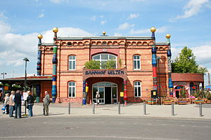
- The 1 railway station was built in 1847. It was just a stopping point. The current building was developed in the Wilhelmine style in 1888 and is an island train station between the line to the west and the lines to the north, south and east. That probably explains the unusual numbering of the platforms, which are all three-digit. To the Expo 2000 in Hanover the station was selected as an expo project. The Viennese artist Friedensreich Hundertwasser was won over to design the station. It was the artist's last project. The station was completely rebuilt and therefore bears the name today Hundertwasser train station. You can visit the Hundertwasser train station in a one-hour tour. This takes place daily at 11:00 a.m., but prior registration is required between December and February. But you can also book separate tours through the organizer. The tour costs 5 euros (as of 2016). (Side of the Hundertwasser train station)

- 3 town hall at Herzogenplatz
- 4 Old Town Hall - built 1789 - 1790
- 1 Imperial Post Office in the Bahnhofstrasse

- buildings worth seeing in the old town in the pedestrian zone, Lüneburger Str./ Gudesstrasse area
Monuments
- Ulenköper monument
Museums
Streets and squares
Parks
- 5 Game reserve in the Uelzen city forest
various


- Way of the stones: about 20 stone sculptures weighing tons, colorfully painted by the artist Dagmar Glemme, point the way from the train station to the city center
activities
- 1 BADUE, Veerßer Str. 77, 29525 Uelzen, Germany. Tel.: 49(0)581 960311. spacious indoor and outdoor swimming pool.
- Bike tours around Uelzen - Around the city, 600 km of well-marked paths invite you to go on bike tours. Uelzen is also on the Weser-Harz-Heide long-distance cycle path.
shop
kitchen
nightlife
accommodation
Learn
Work
security
health
Practical advice
trips
- Museum village Hösseringen (about 18 km southwest) - open-air museum on the subject of "heath culture", the Lüneburg Heath region. In a small heathland you can find historical buildings from the region (Museum side).
Excursions to the heathland around Uelzen
The heather usually blooms in August and September. Around Uelzen you will find some heathland, the visit of which can be optimally integrated into a bike tour:
- Ellerndorfer Juniper Heath (about 17 km to the west). The Ellerndorfer Wacholderheide is a very attractive heather area due to its juniper population. With a size of 60 hectares, it is the largest heathland in the Uelzen region. Circular hiking trails open up the area. By the way, there is a snack in the sheepfold at the parking lot. Location parking lot: 52 ° 59 ′ 9 ″ N.10 ° 18 '23 "E
- Little London Heath (about 12 km south) - The elongated, 15-hectare piece of heather is embedded in the hilly pine forest area of the Wieren mountains. A sandy path about 1 km long opens up the area. Location: 52 ° 52 ′ 15 ″ N.10 ° 36 '15 "E.
- Bad Bodenteicher Heide (about 15 km south). In the southern area of the Wieren Mountains near Bad bodenteich, there are two heathlands of around 40 hectares in total. The smaller, eastern heather area is made accessible by the "Bodenteicher Heide" nature trail. There is also a sheepfold and an apiary in the area. Location: 52 ° 50 ′ 55 ″ N.10 ° 39 ′ 21 ″ E. Those who visit the Bodenteicher Heide can also pay a visit to Bad Bodenteich with Seepark and the castle (Site of the castle museum).
- Bokeler Heide (about 20 km south) - 18 hectares of heathland with juniper stands. Location of the parking lot right next to the area: 52 ° 47 ′ 31 ″ N.10 ° 33 '47 "E.
Note: The distances are approximate as the crow flies from Uelzen city center.
literature
Web links
- http://www.uelzen.de - Official website of Uelzen