 | |
| Ratanakiri Province | |
| Capital | Banlung |
|---|---|
| Residents | 149.997 () |
| surface | 10,782 km² |
| prefix | 075 |
| no tourist info on Wikidata: | |
| location | |
 | |
Ratanakiri(Khmer: ខេត្ត រតនៈ គិ រ) is the northeasternmost province Cambodia at the borders too Vietnam and Laos
Regions
Administratively, the province is divided into 9 districts Andoung Meas(អ ណ្តូ ង មាស), Ban Lung(បានលុង), Bar Kaev(បរកែវ), Koun mom(កូនមុំ), Lumphat(លំផាត់), Ou Chum(អូរជុំ), Ou Ya Dav(អូរយ៉ាដាវ), Ta Veaeng(តាវែង) and Veun Sai(វើ ន សៃ)
places

- 1 Banlung


 in the Wikidata database") - Capital and center of the province
- Capital and center of the province - 2 Lumphat - The 1.5 hour and 35 km long journey from Banlung is only possible with a moped or four-wheel drive vehicle. It goes a bit on RN 19 towards Stung Treng. After 7 kilometers you turn left.
- Wunsei (old name: Virachey) - 35 km from Banlung

Other goals
- Yaklom lake - Crater lake in the middle of the jungle
- water falls Ka Choung and Cha Ong - 7 kilometers south of Banlung, and Ka Tieng 3 kilometers west of Banlung.
- Bay Srok - Gem mines 35 km east of Banlung
- 1 Virachey National Park

 - The national park can be explored with guided trekking tours.

background
The name of the province translates to place of Gemstones and mountains. The name is a combination of the two Sanskrit words ratna (Gemstone) and giri (Mountain). Surrounded by the Accountum and Chhlong plateau and traversed by the Tonle Kong, Tonle San and Tonle Srebok rivers, large parts of the province are covered by dense jungle. Many rare animals, many of them already threatened with extinction, still roam the wilderness undisturbed here.
21 minorities from Cambodia still live here - the self-sufficient mountain peoples of the Khmer Loeu. Ethnic groups like the Tampuan, Kreung, Charai, Kaco, and Brau / Kavet live here secluded and with little influence from the rest of the world - still. Business people and missionaries have already discovered this region for themselves.
language
In addition to the ubiquitous Khmer, you can also find the native languages of the 21 ethnic minorities living here. The people who come into contact with tourists also speak English. In Stung Treng speak about 50% Lao. Lao is predominantly spoken in Siem Pang and Lumphat.
getting there
By plane
There is currently no regular air traffic to the region. But there are plans to revitalize the airfield in Banlung.
In the street
Of Pleiku You can get out at the border crossing recently Lệ Thanh/ O Yadao enter via the Vietnamese border. The travel time between the two cities on a road that was newly built in 2009 is around three hours, plus border clearance, which can take an additional hour. Lệ Thanh is about 70 kilometers from Banlung.
mobility
There are hardly any paved roads in the province. The only exception is the route from Banlung to the Vietnamese border. The condition of the slopes is sometimes poor, especially after heavy rainfall. You either go by motorcycle, pickup or truck.
Tourist Attractions
Ratanakkiri is like the southern province Mondulkiri 80% inhabited by 21 minorities with different languages and cultures. The best known are the Charai, Kaco, Tampuan, Kreung and Brau. There are also numerous Laotians, Vietnamese and Chinese. The province is attractive for tourists. A few kilometers outside the provincial capital Banlong you can already find thick forests. Rubber plantations, which were planted by the French in the 1960s, are also cultivated here.
- Yaklaom. A legendary lake of volcanic origin about 3 km northeast of the city, approaching Vietnam.
- water falls. They are one of the main attractions in the province. Chha Ong is an 18 meter high waterfall in the middle of the jungle, just like the 10 meter high one Ka Tieng. Also Kan Chang and Bai S'rok are popular waterfalls.
- Visitors can use the Minority villages seek it out yourself. However, special attractions, such as traditional cemeteries (such as in the village of Ka Choan), can only be entered in the company of a local guide who has obtained permission from the village elder.
- Be in several places Semi-precious stones reduced. The Zircon mines are the most famous and accessible mining area, too Three-Districts mining area called. It resembles a cheese with holes in it. Hundreds of 60 cm wide and 12 meter deep holes have been driven into the earth here.
- Elephant Trekking: These animals are found in the wild in Ratanakkiri, but are also used by the minorities for slash and burn. Some of these elephants from the Airavata Foundation can go on trekking tours at Ka Tieng Waterfalls.}}
Temple ruin:
- 2 Prasat Yak Nang (ប្រាសាទ យ៉ា ក់ ណាំង)..Small Hindu temple ruins from the 7th and 8th centuries, secluded in the jungle. She is also influenced by the Champa. The Jalai minority live in the area. You can get there by moped from Banlung, but you still have to cross the river.

Wunsei
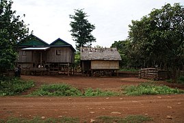
Village in Ratanakiri

Golden Buddha in Banlung

Cha Ong waterfall


activities
Trekking: The remote province offers very good trekking opportunities. The offer ranges from day trips near the provincial capital to multi-day tours. Even a week tour of the Virachey National Park is possible. But this is quite exhausting - and not very comfortable.
- Virachey Ecotourism, Banlung. Tel.: 855 (0)77-965196, Email: [email protected]. Mr Thon Soukhon organizes tours to Virachey National Park.
