- For other places of the same name, see Route of Legends (disambiguation).
| Route of Legends | |
 | |
| The "Bouillon de la Chaudière" | |
| Information | |
| Departure | Remouchamps |
|---|---|
| Arrival | Remouchamps |
| Length | 120 km |
| Altitude | Between 99 and540 m |
| Duration | one to two days |
| Country | |
| Regions | Province of Liège Ourthe-Vesdre-Amblève |
| Tourist information office | |
| Location | |
 50 ° 29 ′ 13 ″ N 5 ° 42 ′ 54 ″ E (Modified GPX file) | |
| Official site | |
| Touristic site | |
The "Route of Legends "Is a double loop in the tourist region of"Ourthe-Vesdre-Amblève »For motorists and motorcyclists with Remouchamps as a point of departure and arrival.
Understand

Created and managed by the Tourism Federation of the Province of Liège, this route takes you from Remouchamps, but can be started at any place where there is a beacon, from castles, in farms, in small villages having kept their character of yesteryear, in natural curiosities and enchanting landscapes before bring you back to your starting point after a motorized journey of 120 km. This distance can be increased by approximately 13 km motorized and approximately 10 km in a pedestrian way depending on the places of interest which you would like to explore further.
If, in principle, 120 km can be easily covered in a day, it would be preferable to plan at least one stopover where to sleep if you decide to explore all the possibilities of sight and activity. The center of Aywaille and Remouchamps, being in relation to the entire route positioned centrally, will be ideal places to stay. There you will find hotels, rural lodges and campsites.
The circuit can also be accomplished by seasoned cyclo-tourists, but it will then be necessary to plan one or two additional stages.
Steps
- 1 Departure Ourthe-Vesdre-Amblève Tourist Office (rue de Louveigné 3)
First loop
- 1 Remouchamps caves rue de Louveigné,
 32 4 3609070
  open all year except the 1D fortnight of December Mon.- Sun. : 10 h - 17 h 30.
  (2015) adult: 14 €, senior (60 years old): 12 €, child (3 to 11 years old): 9 €. –
 Magnificent limestone caves that were formed over a million years ago thanks to the action of an underground river, the Rubicon. Long 1,500 meters, the circuit of the visit which lasts approximately 1 h 30 starts, on foot, over a distance of 800 meters dotted with no less than 400 steps and allows you to admire, among other things, the hall of ruins and its suspended block of around forty tons, the large drapery from a height of 7 meters and formed by rainwater turning into crystalline deposits, the room of the virgin and its stalagmite evoking the Virgin Mary carrying the baby Jesus, the large gallery and its calcite dams and finally the cathedral, high of 40 meters and deep of 100 meters. The route continues with a long underground navigation 700 meters during which you may be able to spot blind niphargus shrimp (Niphargus fontanus) and whose main attraction is the palm, a column formed by the junction of a stalactite and a stalagmite and whose curious position, in the middle of the Rubicon, is a unique phenomenon. The visit ends optionally with a small museum, the entrance to which is included in the price of the ticket, dedicated to the caves and the Vallon des chantoirs. Please note that animals are not allowed in the caves.


 NOT633
- Aywaille
 NOT30
NOT30- NOT86
- Awan (Aywaille)
- Awan-Goza
 Rue des Pansires
- Route de Cwimont
 Rue des Bruyères
- Rue des Genets
- Aubépines Street
- Rue des Sorbiers
- Rue des Prunelliers, La Mohinette, AY7 (and yes! It's the name of a street)
- NOT633 (avenue Fernand Cornesse)

- 1 Elven Brewery Raborive 2 (left after the railway bridge), 32 4 2630717 sea.- sat. : 10 h - 16 h 30. 10 € (tasting visit) (duration: approximately 1 h. –
 The visit includes a detailed explanation of the stages of the manufacturing process of their beers as well as a tasting of a selection of their products.
 - 2 Ruins of Amblève castle (Ruins of Emblève castle) (on the cliff above the Elvish brewery) – Built in one of the seven “seigneuries beyond the woods” dependent on the Duchy of Limbourg, the oldest parts date from the IXe century. It was mined in 1578 by Spanish troops during the Eighty Years' War. Two legends are attached to this castle. The first is that of the 4 sons Aymon and their horse Bayard who found refuge there during their flight from the troops of Emperor Charlemagne. The second tells that every two days before All Saints' Day, a ghost roams the ruins, dragging two corpses attached to the skirts of his dress; it is Blanche de Monfort, condemned to return to the theater of her crime of passion with the bodies of those whom she has united in death.
- Aywaille
- Rue de l'Yser
- Avenue of the Centenary
- Rivage Street
- Two large free parking areas with no time limit to stop at Aywaille, have a drink or have a bite to eat.
- NOT30 (Grand Route)
- Chera old street
- NOT30 (Grand Route)
- Sprimont
- (before the Saint-Martin church) Rue Chapuis
- Damré Street
- NOT678 (rue Joseph Potier) or alternative route of 1.1 kilometers via the NOT678 (rue Joseph Potier). Course highlighted in sea green on the map :

- Wolf Street
- Vaçale Street
- 2 CFS (Sprimont railway) rue du Mierdy 2b, 32 4 3822029, e-mail : [email protected] open all year round by reservation or on days advertised on the website. (2015) adult: between 6 € and 7 €, children (3 to 12 years old): 5 € and 3,5 € according to the thematic day. – Railway industrial archeology museum underway 60 cm, the material is presented in motion. Railway equipment rides along part of the old narrow gauge Poulseur-Sprimont-Trooz local line or in the old Parisian bus Renault TN6A.
- Rue de la Chapelle
- 3 Strong house rue de la Chapelle 4 private house. – Built in XVe century in sandstone rubble and limestone, this imposing square building with hipped roof was owned by the abbey principality of Stavelot. If only two remain, originally each angle had its own watchtower on crows.
- 4 Chapel of Our Lady of the Sacred Heart rue du Loup
- Wolf Street
- NOT678 (rue Joseph Potier)
- 5 Stone museum rue Joseph Potier 54 (entrance on the left of the road), 32 4 3822195, e-mail : [email protected] Mon.- Fri. : 9 h - 12 h and14 h - 17 h, Sun. : 14 h - 17 h. (2015) adult: 4 €, child: 1,5 €. – Located in the old power station of the neighboring quarry, this museum has a large collection of fossils discovered in local quarries. Also, presentation of all the Belgian construction stones currently in use and the tools used in the different stages of stone processing, from the rock to the finished product. At the end of the course, video projection relating to stonework as it is done today.
- NOT678 (rue Joseph Potier)
 NOT30 (Fond Leval street)
- Rue des Fosses
- Rue du Brouckay
- Lileutige Street
- NOT678 (rue Mathieu Van Roggen)
- Rue du Roi Pahaut
- Fair Street
- Liberty Street
- Rue de Focroulle
- Rue Sart le Coq
- Rabohaye Street
- Rue du Houmier
- Hollu Street
- bridge over the railway
- Castle Street
- NOT633 (Halleux street)
- Pont de Sçay (Comblain-au-Pont)
- Rue de l'Aunaie
- Oneux (Comblain-au-Pont)
- Rue du Thier
- Hoyemont (Comblain-au-Pont)
- Route de Hoyemont
- NOT86 (route de Marche)
- Route de Harzé (or Pironbœuf)
- Xhoris Street
- Harzé (Aywaille)
- NOT30 (rue de Bastogne)
- Château de Harzé parking lot: pass under the porch and turn directly left following the sign P

- 6 Harzé Castle rue de Bastogne 1 open all year. access to the lower courtyard and the upper courtyard are free, access to the castle is, in principle, reserved for clients and seminarians. – Erected from a fortified house dating from IXe Where Xe century (the right part on two levels), the castle and its outbuildings, as they stand today, were built in several phases between 1632 and 1753. It is a magnificent example of style. Renaissance mosane in ruled blue stone rubble. Starting from the lower courtyard (the front courtyard), the passage between the old fortified house and the museum gives access to the upper courtyard with a view of the old castle cemetery. The premises are currently the property of the province of Liège and serve as a setting for seminars as well as a restaurant with Liège and international cuisine and a hotel with 24 rooms, The p'tite Auberge
 (8 steps to access the terrace). For the record, the castle was requisitioned by the American army during the Second World War to install the headquarters of the 18th Airborne Corps and saw pass, on December 24, 1944, the Field MarshallBernard Montgomery and, on December 28, 1944, General Dwight Eisenhower.
- Museum of flour milling and bakery (in the outbuildings of the castle), 32 86 212033 from 1er May to October 31: Sun. and public holiday 14 h - 18 h, from 1er July to August 31: sat.- Sun. : 13 h - 18 h (also public holiday). (2015) adult: 4 €, child 3 €. – (1 step at the entrance and no elevator for the first floor). This museum tells the story of bread and its journey from grain to bread. The route begins with the reconstruction of an authentic water mill. Hundreds of rare and unusual objects, an old workshop, kneaders and beaters that turn before your eyes, evoke the hard work of bakers. They reveal their little secrets to you and let you taste their production.
- Museum of flour milling and bakery (in the outbuildings of the castle),


- NOT30 (rue de Bastogne)
- Pavillonchamps
- alternative route of 1.1 kilometers, about 270 meters after the 2e lace on the left. The route is underlined in crimson on the map :
 Rue des Trixhes and follow the signs Animal cemetery
- 7 Animal cemetery rue des Trixhes, 32 4 3845170 sea., sat. and Sun. : 9 h - 16 h 30. free. – Inaugurated in 1984, it is the first of five of its kind in Belgium (one in the Flemish Region and four in the Walloon Region). The land of about 5 000 m2 is a landscaped park with lots of trees, breathing calm and serenity. Unlike the animal cemetery of Cork which also accepts horses, here only pets are buried (dogs, cats, birds, rabbits).
- Trixhes Street
- Pavillonchamps
- Pavillonchamps
- Pré au Fourneau Street
- Wayai Street
- Pré de Lhoneux Street
- path
- Rue du Rixhon
- Rue des Tilleuls
- Houssolonge (Aywaille)
- NOT30 (Houssolonge)
- Pouhon (Aywaille)
- Alternative route of 1.3 kilometers round trip underlined in Brown on the map :

- When entering the bend, take the street on the right and park your vehicle directly
- Take the forest path indicated by the sign
 Chapel of Ste Anne
- 8 Sainte-Anne des Pouhons Chapel – Built in 1524 in a place where many furnaces and forges were active in this region rich in iron, it is dedicated to Sainte-Anne and Saint-Remacle. It is the only vestige of the seigneury of Pouhons. The chapel, of which the nave is a single nave, is rectangular in shape with gables at an acute angle, built of sandstone rubble and covered, like the walls of the steeple, with slates from Lienne. Next to the chapel, a relaxation area including a barbecue allows you to picnic in peace. Every Sunday closest to November 11, a blessing of horses, teams and dogs takes place under the music of horn sounders.

- NOT30 (Grand'Route)
- Pouhon
- Faweux
- Faweux (on the right, the road is called "La Levée")
- Ernonheid-Village
- Ernonheid (Aywaille)
- Rue du Doyard
- NOT66 (The Grand Trixhe)
- September 7 Street
- Heather Fagnette
- NOT30 (Aywaille road)
- Werbomont (Ferrières)
- Rivage Street
- NOT66 (Route de Stavelot)
- Ufny
- Oufny (Stoumont)
- NOT645 (Forges)
- Les Forges (Stoumont)
- NOT645 (Forges)
- NOT645 (The Lienne)
- Chession
- Chession (Stoumont)
- Chession (on the left, the road is also called "Chession")
- NOT645 (The Lienne)
- NOT633 (Route de l'Amblève)
- Quarreux (Aywaille)
- Quarreux
- Quarreux (on the right, the road is also called "Quarreux")
- Quarreux (on the right, the road is still called "Quarreux")
- NOT633 (Sedoz) or alternative route via the NOT633 (Sedoz). The route is underlined in olive on the map :

- leave the vehicle in the car park after the hotel-restaurant At the Devil's Mill
- take the path "Excepté Camping" indicated by the sign Quarreux background
 . Round trip distance, on foot or by bike, between 1 and 2 kilometers as you wish.
 - 9 Quarreux Fund (Tag
 (GR 571) or
  (AY 18b)) – A tumultuous part of the Amblève strewn with enormous quartzite blocks. The resistance of this type of rock explains that at the place of the Fonds de Quarreux the valley is deeply steeped. The erosion of the slopes during the Quaternary era caused landslides towards the bed of the river, causing boulders of all sizes. These materials were washed away by successive floods except, precisely, the blocks of quartzite because of their large size. Located in the municipalities of Stoumont and D'Aywaille, the most spectacular part is on the latter. Like all somewhat mysterious places, the place has its legend: in exchange for its soul, Hubert Chefneux, miller from the Fond de Quarreux, obtained from the devil the beautiful windmill he dreamed of. But, anxious to save this soul, the miller's wife was on the watch. She hid in the mill, clutching a medal of Our Lady of Dieupart in her hands and prayed all night. At sunrise, the wheels of the mill refused to turn and, mad with anger, Satan brought down the mill, the colossal blocks of which tumbled down the slope to the bed of the Amblève.
 - return to the parking lot
- NOT633 (Sedoz)
- NOT633 (Sedoz) or alternative route via the restaurant parking lot Ninglinspo (sign Ninglinspo Valley). Round-trip distance, on foot, approximately 1.32 kilometers for the "Bath of Venus". The total length of the Ninglisnpo to its source at Vert-Buisson is 3 kilometers. The beginning of the course is underlined by light sea green on the map :
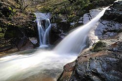
- 10 Ninglinspo Valley (Chaudières valley) (Tag (GR 15) or
 (AY 21)) – Valley of the Ninglinspo stream, a tributary of the Amblève, classified as an exceptional real estate heritage of the Wallonia. With a drop of 250 meters and an average slope of 7.5%, it is one of the fastest rivers in Belgium. It is also characterized by the presence of ten natural vats formed by the continuous action of torrential waters from the heights on the soft rocks and bearing the evocative names of “bath” or “broth”. In some of these tanks the water is deep enough to swim and the rock of the waterfall forming the tank smooth enough to be able to slide through the water without hurting yourself. There are two trails to follow the stream; the first follows it as closely as possible and is not recommended when accompanied by young children, the second follows it at a greater distance but is much easier to cover. Along this second path, we can also see a 11 pedunculate oak (Quercus robur) whose dimensions in October 2013 were 3,75 m circumference at 1,50 m soil and 26,80 m from above.
- 10 Ninglinspo Valley (Chaudières valley) (Tag
- The main tanks are, in the order of appearance along the route,:


- 12 Boiler broth
- 13 Bath of the naiads
- 14 Hermes bath
- 15 Otter bath
- 16 Deer bath
- 17 Diane's bath
- 18 Venus bath
- return to the parking lot
- NOT633 (Sedoz)
- Remouchamps (Aywaille)
Second loop
 NOT697 (Rue de Spa)
- NOT697 (Route de Remouchamps). 660 meters after the sign "Ardenne bleue", 1 rest area on the left with tables and benches for picnicking. Please note that the entrance is at the end of the rest area.
- Hautregard (Theux)
- NOT606 (Route du Ménobu) or alternative route via the NOT606 (Jehoster Street) (4.8 kilometers return trip by car plus maximum 1,146 meters on foot to the arbor). The course (including the arbor) is underlined in dark purple on the map :
- Jehoster (Theux)
- NOT606 (Jehoster Street)
- Rue des Hauts Marais
- Autumn Fog Alley
- First path on the right
- The Veque

- 19 Charmille du Haut-Marais open 7 days a week, 24 h /24. free. – Planted for the most part in 1885 and long 573 meters in a straight line, it is one of the longest walks of this type in Europe. This real plant tunnel is made up of 4,700 plants common charms (Carpinus betulus).
- do the reverse route to Hautregard
- NOT606 (Route du Ménobu)
- 19 Charmille du Haut-Marais
- NOT606 (Route du Ménobu)
- NOT606 (Rue Croix Colette)
- Fond Marie Street
- 3 Forestia Rue Fond Marie 563, Becco, 32 87 541075, e-mail : [email protected] open all year round except Mondays and Tuesdays from mid-November to mid-March from 9 h 30 - 18 h 30. (2015) depending on the activities chosen (animals, adventure, climbing) adults, seniors and children over 12 years old: from 13 € To 30 €, children between 8 and 11 years old: from 11 € To 21 €, children from 3 to 7 years old: from 9 € To 14 €, under 3 years old: free. – (only the animal park). Animal park centered on animals, in semi-freedom, living or having lived in the Ardennes and adventure park with nine courses including 1 from the age of 2 years as well as a climbing wall of 12 m. Restaurant (The Forest Bar).
- Fond Marie Street
- Fagne Saint-Remacle
- NOT606 (Route du Grand Pierreux)
- NOT62 (Rue de Theux)
- Chaityfontaine
- NOT666 (Avenue Paola)
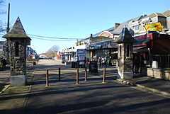
- 20 Banneux (Sprimont) (Banneux Notre-Dame) – Banneux is a place of Marian pilgrimage with a so-called miraculous water source. The Virgin would have appeared there eight times at the place of the current 21 Chapel of the Apparitions (inaugurated on Assumption Day 1933) at Mariette Becco, then aged 12, between January 15 and March 2, 1933 as she looked out of her window. 22 House . During the apparition of January 18, the "beautiful radiant lady" leads Mariette to a place by the side of the road, and invites her to dig the ground with her hands, which has the effect of making the 23 miraculous source . The "reality of the facts" was officially recognized by the Catholic Church in 1952 and the monumental complex of the "Source" was inaugurated in 1958. Currently, the sanctuary also has a hospice for sick pilgrims (Hospitality Banneux Notre-Dame) with 300 beds and a 1 emergency . During the pilgrimage season between May and October, there are daily blessings from the sick and several masses for pilgrims as well as organized activities for children and young people. The site is visited annually by around 700,000 visitors or pilgrims, some 10,000 of whom are sick. Every August 15 is also the occasion of a great pilgrimage for the Roma. Rue de l'Esplanade, which is a pedestrianized street, you will find many food places and shops selling religious objects and souvenirs. In the car park, at the edge of the street, you will also find a fenced playground with wooden furniture.


- NOT666 (Avenue Paola)
- Mihet Street
- Village square
- 24 Saint-Léonard Church village square – (4 steps at the entrance). The building built at the end of XIXe century in limestone rubble and in neo-Romanesque style is composed of three naves extended by a choir. Inside, the marble baptismal font dates from the XVIIIe century. This is where Mariette Beco went to the office all her life.
- Rue des Fusillé
- NOT666 (Avenue Paola)
- NOT62 (Rue du Perréon)
- Louveigné (Sprimont)
- Gendarmerie Street
- Rue de la Gendarmerie or alternative route via rue du Gravier (500 meters to return to the starting point of the alternative route). The route to the tithe tower is underlined in cyan on the map :
- 25 Tithe Tower rue du Gravier 7 (at the end of the courtyard of the old fortified farm.) – Old fortified tower surrounded on two sides by a moat, but formerly completely surrounded, whose presence is already attested in 1540. Built of sandstone and limestone rubble, it once marked the border between the principality of Stavelot, of which Louveigné was part. , and the Duchy of Limbourg. It cannot be visited but is visible from the courtyard of the old farm.
- Rue du Gravier (do not turn around, it's a one-way street)
- NOT62 (Rue du Perréon)
- Gendarmerie Street
- 25 Tithe Tower rue du Gravier 7 (at the end of the courtyard of the old fortified farm.) –


- Rue de la Gendarmerie or alternative route via rue Trôleu (320 meters round trip by car). Course highlighted in denim blue on the map :
- 26 Chapel of Notre-Dame de Bon Secours du Trôleu rue Trôleu – Built in 1708 in whitewashed rubble with original lighting of the wooden openings, the chapel, the neighboring land and the two lime trees, planted during the construction of the sanctuary, which shade it are classified as part of the real estate heritage of the Wallonia. Note the tree on the right, completely hollowed out and yet in good health. Four adults can easily stand in the cavity.
- Rue Trôleu
- Gendarmerie Street
- 26 Chapel of Notre-Dame de Bon Secours du Trôleu rue Trôleu –
- Rue de la China
- Blindef (Sprimont)
- Blindef
- 27 Sint-Hubert and Holy Virgin Chapel Blindef every Friday at 18 h for the office. free. – (3 steps at the entrance). Built in 1762, it is in limestone and was restored in 2007. The interior is sober with the exposed rubble walls while the choir has two stained glass windows of modern inspiration placed after the Second World War at the expense of the parish priest. era. The chapel is classified as part of the real estate heritage of the Wallonia.
- Sendrogne Street
- Sendrogne (Sprimont)
- Sendrogne Street
- Homay-Ogné (Sprimont)
- Rue Cléchêne
- Rue de Histreux
- Stapelette Street
- unnamed path
- Rue des Spinettes
- NOT678 (Rue de la Gendarmerie)
- NOT666 (Rue de Remouchamps). This portion of the NOT666 to the Amblève valley, take the Vallon des chantoirs because of the 70 listed singers whose waters form the Rubicon River which flows in the Remouchamps caves.
- Deigné (Aywaille)
- NOT666 (Deigné Fund) or alternative route via Fange de Deigné to the huge advertising panel "Wild World" (1.5 kilometers by car to the parking lot). The route is underlined in spring green on the map :
- 4 Wild World Mire of Deigné, 32 4 3609070 from mid-March to mid-October Mon.- Sun. : 10 h - 18 h (later during school holidays). (2015) adult: 19 €, senior (60 years old): 17 €, child (3 to 11 years old): 15 €, supplement for a visit with the little train: 3 €, car park : 4 €. –
 Animal park presenting fauna from all over the world in a natural setting. Part of the park is traveled by car (neither by motorbike nor by bicycle) or with the small road train and part is traveled on foot. Shows of sea lions, parrots and raptor flight (included in the price of the entrance ticket). Self-service restaurant with African and brasserie cuisine, bar with terrace, playground.
 - reverse route via Fange de Deigné
- NOT666 (Deigné background)
- 4 Wild World Mire of Deigné,
- NOT666 (Sècheval)
- NOT666 (Rue de Louveigné)
- Arrival Ourthe-Amblève Tourist Office (rue de Louveigné 3)
To go
Although the route can be started at any point where there is a directional sign ![]() specific to this one, the ideal is despite everything to start it at the Ourthe-Amblève Tourist Office. If only to get tourist brochures or to follow this article from the beginning.
specific to this one, the ideal is despite everything to start it at the Ourthe-Amblève Tourist Office. If only to get tourist brochures or to follow this article from the beginning.
Coming from the west
Follow the national road NOT633 which crosses this part of the Amblève valley as far as the Sougné-Remouchamps bridge which spans this river, continue straight on the NOT666 in the direction of Louveigné. The Tourist house is on the left, 100 meters after crossing the bridge.
Coming from any other direction
Join the European route E25, exit 46![]() Remouchamps. Take the national road NOT633d Then NOT633 following the signs
Remouchamps. Take the national road NOT633d Then NOT633 following the signs ![]() Remouchamps Arrived at the Sougné-Remouchamps bridge which spans the Amblève, continue straight on the NOT666 in the direction of Louveigné. The Tourist house is on the left, 100 meters after crossing the bridge.
Remouchamps Arrived at the Sougné-Remouchamps bridge which spans the Amblève, continue straight on the NOT666 in the direction of Louveigné. The Tourist house is on the left, 100 meters after crossing the bridge.
Circulate
Whether by car or bicycle, you should have no difficulty in getting around or finding a parking space, even in large tourist centers. Be careful, however, that some small roads are quite narrow and winding and that you should be extra careful if you are traveling in an imposing motorhome. The sections of the route between Pré de Lhoneux street and rue du Rixhon in Harzé as well as between the exit of the village of Chession and the national road NOT645 have no floor covering but are easily walkable.
To buy

- Craft beers from the Elvish micro-brewery To Elven Brewery.
- Bread or pastries produced at flour mill and bakery museum.
- Organic cheeses from the Fromagerie des Ardennes To Werbomont.
- For lovers, religious objects and souvenirs at Banneux Notre-Dame including bottles of holy water from the miraculous source.
Eat
You will have no difficulty finding a place to eat along your route. The highest concentrations of this type of place are in the center of Aywaille, in Remouchamps and in Banneux. Leisure parks Forestia and Wild World are also equipped with one or more places to eat. For those who prefer a picnic, the sections on the small roads along the woods or forests should allow you to find a place that suits you without forgetting the general safety instructions. However, the Sainte-Anne des Pouhons chapel is a calm and bucolic place that should delight you, especially as the place is equipped with a barbecue.
Have a drink / Go out
As for dining, you will have no difficulty finding a place, especially in the center ofAywaille, To Remouchamps and to Banneux, where to quench your thirst (and, perhaps, taste, in moderation, one of the local beers).
Security
In forest areas, it is best not to drive on temporarily closed paths, during the hunting season for example (be careful that hunting when approaching and on the lookout for wild boar (Sus scrofa scrofa) is authorized all year round), and informed by a reasoned opinion and provided with a pictogram on a red background. Camping and the production of fire is prohibited everywhere in the forest and traffic outside the paths is strongly discouraged. Always obey the instructions and orders of the agents of the DNF. Also note that they are empowered to draw up an offense report in the areas of air, water and soil pollution, noise damage and waste abandonment. Therefore, if you are picnicking, take great care not to light a fire outside clearly authorized areas, to take your trash and to make the place look like it did before you arrived.
Regarding flora, there is no ban on collecting mushrooms that you are sure to recognize as non-toxic. The same goes for wild fruits or apples and pears in old unfenced orchards. The only defense is the use of a blueberry comb.
- 2 Department of Nature and Forests (Aywaille DNF cantonment) rue du Halage 47, 4920 Sougné-Remouchamps (after and behind the no 45), 32 4 2479991, 32 477 781206 (cellphone)
- 3 Liège zone 5 Playe 50, 4920 Aywaille, 32 4 3846835 – Firefighters and ambulances. Emergencies: free phone 112.
Around
- Vieuxville (Ferrières)
- 1 Vieuxville Chapel – (1 very high step at the entrance) (murals). Romanesque chapel of XIe Where XIIe century.
- 2 Logne Castle – Ruins of a medieval castle IXe century.
- 1 Vieuxville Chapel –
- 3 Museum December 44 (Stoumont) – Museum dedicated to the Battle of the Bulge.
- 4 Coo (Stavelot) – Known for its waterfalls, the most important in the country, and its leisure park.
- 5 Franchimont Castle (Theux) – (in part only) Medieval castle IXe century.
(center to center)
| Destination | Distance | Time | ||
|---|---|---|---|---|
| by the road | great circle | by car (about) | ||
| Brussels | 122 km | 104,3 km | 1 h 20 | |
| Durbuy | 27,3 km | 23 km | 30 min | |
| Cork | 25,7 km | 19,4 km | 20 min | |
| Spa | 14,1 km | 10,9 km | 15 min | |
| Verviers | 21,7 km | 16,5 km | 25 min | |