 Hold the Carnatic | ||
| Shaāb Abū en-Nuḥās شعاب أبو النحاس | ||
| no tourist info on Wikidata: | ||
| ||

The Sha'ab Abu en-Nuhas or short Abu en-Nuhas (also (Sha'ab / Shaab) Abu Nuhas, Arabic:شعاب أبو النحاس, Shaāb / Shiʿāb Abū an-Nuḥās, „Reef of the father of copper") is a egyptian Coral reef and Wreck and reef diving area in the Strait of Gūbāl in the south of the Gulf of Suez, about 3 nautical miles (5 kilometers) north of Schadwān Island (also Shadwan Island or Shaker Island). Due to the proximity to the ship routes, the reef, which was not marked with a beacon for a long time, became the undoing of several ships. The steamboat is one of the most important wrecks Carnatic and the cargo ship Giannis D.
background
Location of the reef and the ship graveyard
The reef of Scha'b Abū en-Nuhās is located in the Strait of Gūbāl (Arabic:مضيق جوبال, Maḍīq Ǧūbāl, „Strait of Ǧūbāl“), The southern gate of the Gulf of Suez, about three nautical miles (5 kilometers) north of the 1 Schadwān or Shaker Island(27 ° 30 ′ 5 ″ N.33 ° 58 ′ 52 ″ E). Together with Shadwān Island, it forms the western edge of the main shipping route Sue.
The reef roof is only a few centimeters below the water surface and can therefore only be discovered late in poor visibility. Due to the location of the reef, there were always accidents here. The Shadwān Island, located to the south, clearly protrudes from the sea. Only in the 1990s was this reef equipped with a lighthouse in the northeast tip.
The reef is roughly triangular and has almost equally long sides. The north side with a length of about 1,200 meters runs approximately from southwest to northeast and is about in the middle by a protruding 2 Coral block(27 ° 34 '48 "N.33 ° 55 ′ 41 ″ E) divided. The east side runs very precisely from south to north. There is one in the southwest of the reef 3 lagoon(27 ° 34 '24 "N.33 ° 55 ′ 38 ″ E), whose 4 Access(27 ° 34 '22 "N.33 ° 55 ′ 30 ″ E) is also located on the southwest side. In the area of the north west side there is a smaller one, about 250 meters long 5 Satellite reef(27 ° 34 '23 "N.33 ° 55 '23 "E). There is only one 40 meter wide channel between the two reefs. A short distance from the southern tip of the reef are three other small reefs, the Yellowfish Reefs.
The reef rises from the sandy bottom. The reef foot is about 18 to 27 meters deep.
Coming from Suez, about six ships ran aground and sank on the north side of the reef between the years 1869 and 1987. There are four wrecks on the edge of the reef. One of the wrecks is the one that sank in 1869 Carnaticwho sank in 1978 Marcus and Kimon M.who sank in 1981 Chrisoula K., which sank in 1983 Giannis D. (Ghiannis D.) and the one that sank in 1987 Olden. The main part of the wreckage of the Chrisoula K. is located about 400 meters north of the reef. The location of the wreckage of the Olden is unknown. Lenses, tiles and wood belonged to the cargo of the ships. Just the charge of the Carnatic, it consisted of cotton, silver, copper, gold coins and mail, was significantly more valuable. In addition to the sunken ships, other ships ran aground, but were able to be rescued from their predicament.
Naming
The name Schaʿāb Abū an-Nuḥās, Reef of the Father of Copper, comes from local fishermen and probably derived from the cargo of the Carnatic from. Local fishermen and divers played a key role in the recovery of the copper bars.
An alternative name, "Reef of the Seven Deaths", refers to seven ships that are said to have sunk here.
Sinking of the Carnatic and salvage of the cargo


The steam sailor Carnatic was at the Samuda Brothers in London for the British Peninsular & Oriental Steam Navigation Co. (P&O) and was launched on December 8, 1862. The shipping company used the ship for combined freight, mail and passenger transport between the Egyptian Sue and India, occasionally until after China. This line was necessary because it was the Suez Canal not yet existed in its time. The ship was named after the Karnatik landscape in southern India. The outdated name described an area in what is today Tamil Nadu, in the southeast of Karnataka and in the south of Andhra Pradesh.
Two sails and a steam engine were intended to drive the ship.
As the Illustrated London News (ILN) reported, were on their last trip from Suez to Bombay 230 people on board, including the 27 crew members. The ship was led by Captain Jones. The ship had loaded cotton, copper bars, 40,000 English pounds in gold coins, silver, mail and food for the passengers. On the night of Sunday, September 12, 1869, to Monday, September 13, 1869, one hour after midnight, the ship ran onto the Abū en-Nuḥās reef shown on the nautical charts in fine weather, weak winds and almost calm seas. Initially it was possible to bring the ship back into deeper water. The master completely underestimated the extent of the damage. However, the engines had to be shut down the following night because the ship was full of water. The following evening the captain gave the order to take the passengers to the lifeboats. On Wednesday morning around 10 o'clock, passengers and crew members were rescued from the steamboat "Sumatra" of the same shipping company. According to this newspaper report, 15 Europeans, including five 1st class passengers, and numerous local, i.e. Asian crew members, died in the accident. In an official letter from the Peninsular & Oriental Steam Navigation Co. from May 3, 1870, the number of fatalities was given as 30, including 15 local crew members.[1]
The Illustrated London News also reported the salvage of the ship about two weeks later. The ship was now partially sunk, but still visible how it was resting on the reef. The fore and main mast were still there. The insurance company Lloyd’s of London sent a rescue expedition with two divers on September 25, 1869 in Suez, who arrived at the wreck on September 30. The ship had meanwhile been looted by locals who were after the cotton in particular. The investigation of the ship began on October 20 and the post was secured on October 24. The recovery of 22 boxes with the gold coins over 32,000 pounds was completed on November 2nd by the two divers. Nothing is known about the whereabouts of the remaining 8,000 pounds in today's value of 250,000 euros.
The copper bars that were intended for the minting of coins were salvaged by locals on behalf of Lloyd’s. The Bedouins employed for this purpose recovered 700 bars weighing 40–70 pounds (about 18–32 kilograms). The recovery of the bars was also described in the ILN:
- “The skill with which the Arabs dive is quite surprising. With a rope around their left arm they go upside down from the boats, swimming steadily down until they reach a bar. Sometimes [they have] between their legs or in their hands when they are pulled to the surface. "
The individual dives lasted an average of 75 seconds and a maximum of 90 seconds.
The Carnatic is also mentioned a little later in a novel. Phileas Fogg, main character in Jules Vernes novel Travel around the earth in 80 days, missed the early departure of the Carnatic steamer, which was supposed to bring him from Hong Kong to Yokohama. However, his valet Passepartout got on the ship in time.
getting there

A visit to the ship cemetery is usually part of a liveaboard safari to the south of the Gulf of Suez, which takes place in Sharm esch-Sheikh or Hurghada begins. The location of the reef can be identified from the lighthouse on the northeast tip. The safari ships can only moor in two places on the southwest side.
Due to the heavy surf, it is very difficult to jump off the safari ship on the north side of the reef. Therefore you should get into a rubber dinghy at the anchorages in the west (Zodiac) with which you can continue to the wrecks.
A dive is only possible when the sea is calm and of medium difficulty. The view is usually quite good. For the interior of the ships, it is advisable to take a diving lamp with you. Since the jump into the water is some distance from the reef, the tour of the wrecks begins at their stern.
Tourist Attractions
Coral reef


The local wrecks are the reason that the coral reef is mostly ignored. It also offers attractive soft, hard and table corals. Animals include perch, batfish, parrotfish, lionfish, moray eels, and tube eels.
The east side of the reef is ideal for a dive, especially as an alternative program in rough seas. The reef edge is covered with soft corals and has caves and canyons.
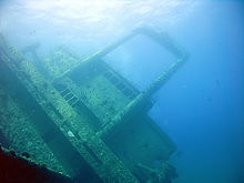
Wreck of the Giannis D.
The Greek general cargo ship Giannis D. (sometimes too Ghiannis D.) was built in 1969 in Japan by Kuryshima Dock Co. and named after Shoyo Maru baptized. The ship changed hands to an unknown owner in 1975 and has been sailing under the name ever since Markos. In 1980 the Greek Dumarc Shipping & Trading Corp. acquired in Piraeus the ship and had it renamed Giannis D. The D. is a reference to the owner. The ship was 99.5 meters long, 16 meters wide, had a draft of 6.35 meters and had a tonnage of 2,932 gross registered tons (GRT). The six-cylinder engine gave the ship a top speed of 12 knots. With a cargo of teak and mahogany, the ship sank on April 19, 1983 due to a navigation error and is now at 6 27 ° 34 '38 "N.33 ° 55 ′ 25 ″ E at a depth of about 27 meters. The deck superstructures reach a height of 7 meters below the water surface. The Giannis D. is the best preserved wreck on Scha'b Abū en-Nuhās and is located on the western north side of the reef.

The wreck broke apart and is now divided into three parts in the sandy bottom. Immediately on the reef is the bow with its bow mast and anchor winch. He is on the port side. Parts of the collapsed cargo hold follow. The third and largest part is the stern, which is inclined to port, with the navigating bridge, the crane boom and the chimney. In the area of the chimney one has access to the spacious engine room, in which the six-cylinder engine with its cam arms and the pipes, valves and measuring devices can be made out.
The ship is now taken over by some soft corals, sponges and anemones. Other inhabitants are perch, glass, bat and parrot fish.
Wreck of the Carnatic, the wine bottle or copper wreck
About 300 meters east of the Giannis D. is the wreck of the steam passenger ship 7 Carnatic(27 ° 34 '45 "N.33 ° 55 '35 "E). That of the Samuda Brothers The ship, built in London in 1862, was 89.8 meters long, 11.6 meters wide, had a draft of 7.6 meters and had a tonnage of 1,776 GRT. In addition to the engine, the ship also had two sailing masts for propulsion. The ship was for the British Peninsular & Oriental Steam Navigation Co. (P&O) between Sue and Bombay, occasionally on the way to China. In good weather, the ship ran aground shortly after midnight on the night of September 12th to 13th, 1869.

The wreck, which was only rediscovered in 1984, is now at a depth of 22 to 27 meters. The bow faces the reef, the ship is on port. Today almost only the rusted iron frames are left of the ship. The wooden blanks are rotten. The iron struts are now completely covered with hard and soft corals. Perch, glass fish and mackerel swim in the area of the ship.
Parts of the bridge, the chimney as well as the stern and bow masts are still preserved from the superstructure. Inside the ship, the holds and the engine room with the engine and the boiler are accessible. At the stern are the three-bladed propeller and the rudder.
Be careful not to injure yourself on the sometimes sharp iron edges.
The two wrecks to the east are viewed much less frequently.
Wreck of the Marcus, the tile wreck


Further east, east of the coral block, is the wreck of the cargo ship 8 Marcus(27 ° 34 '48 "N.33 ° 55 '42 "E). The Marcus was built in Bremen in 1956 and had a tonnage of 2,700 GRT. Until 1971 it ran under the names "Naguilan", "Nordhaff" and "Atlas". After a fire, the damaged ship was sold to Greece and had been sailing again since 1978 under the name "Marcus". Coming from Italy and loaded with Italian granite floor tiles and metal pipes, it ran aground here in May 1978 on the way to Saudi Arabia. The wreck was mistaken for the Greek "Chrisoula K." for a long time.
The bow of the ship is still on the reef at a depth of about 4 meters, the stern further north at 27 meters. Along the ship there are three holds with the tiles and the ship's bridge. At the stern is the four-bladed ship's propeller. The engine room is difficult to access and the visit is only recommended for experienced wreck divers.
The ship is already covered with soft corals, which form the habitat for glass, bat and anemonefish.
400 meters north of the reef, at a depth of 60 meters, are the remains of the cargo ship "Chrisoula K.", built in Lübeck in 1954, which sank on August 31, 1981, also loaded with tiles. Fragments of the bow of the Chrisoula K. also lie on the reef roof. When trying to pull the ship off the reef, it broke apart.[2]
Wreck of the Kimon M., the lens wreck
Almost at the extreme northeastern tip, about 250 meters east of the Marcus is the wreck of the Greek-Panamanian cargo ship 9 Kimon M.(27 ° 34 '53 "N.33 ° 55 '49 "E), which is also known as lens wreck because of the cargo. That in 1952 H. C. Stülcken & Son in Hamburg The ship built had a length of 104.6 meters, a width of 6.8 meters and a tonnage of 3,714 GRT. On its last voyage, it was supposed to transport a cargo of lentils from Iskanderun in Turkey to Bombay. It hit the reef on December 12, 1978. In the process, the bow was torn off, of which only remains are today on the reef roof.
The rest of the hull is now on its starboard side directly at the foot of the reef at a depth of 27 meters. The port side protrudes to a depth of 16 meters. Some remains are also still on the reef edge from 4 meters depth.
The wreck should only be viewed from the outside, as it is now unstable and threatens to collapse. The four-bladed propeller and the rudder, the mast, the open-top cargo holds, the winches, the remains of the chimney and the bridge can be viewed.
The underwater world includes soft corals, perch and bat fish.
Yellowfish Reefs
About 600 meters from the southern tip of the Scha ca.āb Abū en-Nuḥās, south of the reef, are the three smaller yellow fish reefs (English 10 Yellowfish Reefs(27 ° 33 '57 "N.33 ° 55 ′ 47 "E)which are named simply after the color of many of the fish found here. The fish native to this area include red mullets of the genus Parupeneus, Butterfly fish (Chaetodonidae) and sweetlips (Plectorhinchus). The reefs rise from the sand at a depth of 15 meters.
taking photos
Due to the sometimes short distances to the objects, a wide-angle lens should be taken with you. The use of flashlights is required in the holds.
You should experiment a little for recordings. It is quite possible that the use of the flashlight is forbidden due to the sediment and the plankton being blown up. You need a steady hand to take pictures without the flash.
Kitchen and accommodation
Accommodation and meals are provided on the safari ships.
trips
Visiting the reef can be combined with other dive sites in the Strait of Gūbāl Connect as part of a liveaboard.
There are four other coral reefs west of Abū en-Nuḥās. There are no wrecks, but the marine fauna and flora are worth a visit. When planning a dive, it should be taken into account that the current always runs from north to south.
This is located 3.5 kilometers northwest of Abū en-Nuḥās 11 Shaʿāb Umm ʿUsh(27 ° 35 ′ 18 ″ N.33 ° 52 '34 "E.), also Shab / Shaab Umm Usk, Shaab Umm Onghosh, which has a diameter of about 3 kilometers. In the middle of the reef there is a lagoon where the ships can also anchor. Usually on the west side in the northern access area to the lagoon 1 27 ° 35 ′ 2 ″ N.33 ° 52 ′ 5 ″ E submerged.
South of the aforementioned reef and 3.5 kilometers west of Abū en-Nuḥās is the reef and island 12 (Ǧuzūr) Siyūl Kabīra(27 ° 33 '37 "N.33 ° 52 '24 "E), on which there is also a lighthouse. Only a small part of the reef is visible as an island. While the reef measures around 1.8 kilometers from west to east, the island is only 650 meters long. The south side of the reef is interesting for divers. Because of the current, you start the dive in the extreme east or west.
About 1 kilometer west of Siyul Kabīra is the reef and the island 13 Siyūl Saghīra(27 ° 33 ′ 13 ″ N.33 ° 50 ′ 50 ″ E). It is the largest reef in this area and a good four kilometers long. Only an extremely small part in the north juts out of the water as an island. The approximately one kilometer long reef tongue in the east is suitable as a diving area 2 27 ° 32 '55 "N.33 ° 51 '47 "E.. Ships can anchor in the south of the reef tongue. You usually start the dive in the north and circle the reef tongue. The south side of the tongue is also suitable for snorkeling.
South of Siyūl Kabīra is the little interesting one 14 Blind Reef(27 ° 33 ′ 0 ″ N.33 ° 53 '52 "E).
literature
- The Wreck of the Carnatic. In: The Illustrated London News, Vol. 55 (1869), no. 1562 of Saturday, October 16, 1869, p. 390, col. 1 f., P. 381 (fig.), ISSN 0019-2422.
- Recovering the Cargo of the Carnatic. In: The Illustrated London News, Vol. 55 (1869), No. 1568 of Saturday, November 27, 1869, p. 542, Col. 1 f., P. 528 (fig. Above), ISSN 0019-2422.
- : Sinai Diving Guide: Part 1; German edition. Verona: Geodia, 2005, ISBN 978-88-87177-66-4 . Dive sites 37–40.
Individual evidence
- ↑Harrison, Janelle: The S.S. Carnatic: A Historical and Archaeological Analysis of the Underwater Cultural Heritage of a 19th Century Steam Powered Screw Propelled Ship, Bristol: University of Bristol, 2007, dissertation, p. 57, fig. 40.
- ↑Siliotti, Alberto, Sinai Diving Guide, loc. cit., P. 195.
Web links
- Shoyo Maru, Carnatic, Marcus, Chrisoula K., Kimon M. and Olden on wrecksite.eu (free registration required).